
|
RADAR CHECK: Most of the showers and thunderstorms have pushed out of the North-Central Texas region this morning, leaving only a cluster of thunderstorms just south of the Red River. We do note that those storms have triggered a Flash Flood Warning to be posted for a portion of Cooke and Grayson counties until 11:00 AM this morning. For the coverage area this afternoon, I expect mostly dry conditions with a mix of sun and clouds with highs in the middle 70s. However, I can not rule out the potential for a stray thunderstorm or two. Most of our potential third round of heavy rain and strong to severe storms will come during the overnight hours, however. SEVERE RISK FOR MOST OF NORTH AND WEST TEXAS THIS EVENING AND TONIGHT: Current surface analysis reveals a surface low over southwestern Kansas with a quasi-stationary front stretching down to the south across west Texas, extending further to the east across North-Central Texas. The warm sector is characterized by dewpoints in the middle to upper 60s with temperatures reaching the mid to upper 70s in most spots this afternoon. The rich boundary layer in the Big Country combined with daytime heating instability (especially with the sun being out) will cause a risk of severe weather this afternoon and evening for northwest and north-central Texas. The SPC (Storm Prediction Center) has an "enhanced risk" (level 3/5) of severe storms for most of the Big Country and for areas generally north and west of I-35W. The standard "slight risk" (level 2/5) runs through the DFW Metroplex, generally surrounding the Enhanced Risk for about 100 miles apart. Lastly, a "marginal risk" (level 1 of 5) runs through the rest of the North Texas area, extending down towards Central Texas. 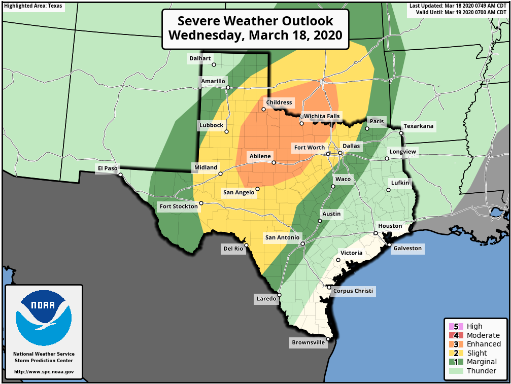 TIMING: Most of the development will take place along the dryline in West Texas at around 5-6PM. The any discrete storm will consolidate into an MCS (mesoscale convective system) later overnight. The severe risk in the North Texas region will run from about 9PM-12AM, with the risk of heavy rain running from midnight to the pre-dawn hours.
THREATS: All modes of severe weather will be possible, just like yesterday night. Large hail and damaging winds will be the primary risk. However, a couple of tornadoes will be possible, like what we saw in Throckmorton yesterday afternoon. There is still a little bit of uncertainty regarding the extent of the spread of heavy during the early morning hours. One of the mesoscale models keeps most of the activity confined to North Texas, while one of them keeps the rain widespread through North and Central Texas. Nonetheless, please keep in mind that North Texas has the best chance of severe with heavy rain chances, which may lead to localized flooding. TOMORROW: The threat of strong to severe thunderstorms will continue tomorrow for our northeastern counties as activity develops from a remnant outflow boundary. Associated lift should support the threat for large hail and damaging winds for those zones. Flooding will be a continued issue in already saturated areas. FRIDAY: Things cool off considerably Friday with a cold front pushing southward late Thursday night into Friday with highs in the 50s and 60s. An upstream shortwave will approach from the south, which will add another chance of showers and thunderstorms which should affect our southernmost counties. Flooding should not be much of concern by that point. We should get a break from the rain Saturday and for most of Sunday with highs in the mid 50s. We will see mostly sunny skies Saturday followed by cloudiness on Sunday. Please keep tabs on our twitter and Facebook page, as we will be updating frequently. Donovan Neal The cold front has stalled to our south and east, and temperatures in DFW have fallen into the 50s. A couple thunderstorms have developed east of DFW along the boundary. A few storms will likely develop in DFW later this evening into the overnight, and a few could be strong with frequent lightning and heavy rain. Coverage will only be 40% or so. Tomorrow will be a cool day with highs in the 60s. Scattered showers and a few t-storms will be possible through the day, but no severe storms are anticipated. As the warm front lifts northward Sunday night, widespread showers and thunderstorms will develop with near an 80% chance of rain. Some of these could turn strong with hail or some gusty winds, but the severe risk remains very low. Below is the European model for late tomorrow evening/early overnight.  Monday morning will have storms around, but we should see some dry weather around midday before redeveloping thunderstorms are likely during peak heating. Highs will be in the low to mid 70s. No severe weather is expected. Dry weather is anticipated Monday night with temperatures in the 60s. However, a few showers or sprinkles aren't ruled out. By Tuesday, the first wave of energy will approach West Texas during the afternoon. Strong to possibly severe storms could develop, and these will be watched as they march eastward. These storms will turn into a squall line, and will make a run at DFW & North Texas late Tuesday night. If it can make the trip, a strong or severe storm with damaging winds and heavy rain will be possible. The level of certainty is very low regarding this timeframe, and we should have a better idea by Monday. The best chance will be in our western counties.  After a few potential morning t-storms on Wednesday, a couple afternoon storms could develop during the afternoon. This will be a timeframe to watch for some severe storms once again, with hail or wind likely being the main threat. Another squall line could develop in West Texas and will make a run at North Texas once again Wednesday evening and night. If it makes it, some strong or severe storms will be possible. These may last into Thursday morning, and this will have a large affect on Thursday afternoon.
Dependent on the speed of the dryline on Thursday and how much destabilization we can have, severe thunderstorms may fire up during the afternoon along the dryline. The best chance will be east of I/35. This potential will be watched the next few days. Stay tuned as we refine the details to this weeks forecast the next few days. Friday will be drier and cooler with highs in the 60s. A strong cold front may move in late in the day and highs could be in the 50s and 60s on Saturday with a chance of scattered rain showers. Severe weather would be very unlikely during this time due to a chillier pattern in place. Logan Shipley Widespread storms rolled in this morning with some severe in DFW, producing damaging winds and hail around 10-11am this morning. However, all of that has moved out and most have been left with a cloudy and mild afternoon. The exception is our northwestern zones where some storms have redeveloped but are currently below severe limits. An enhanced risk of severe storms is in place in far West Texas, where supercellular development is expected within the next few hours. All modes of severe weather will be possible, and this is actually a key to the forecast tonight. These storms will tend to cluster up and will make a run for North Texas. These should stay just N/W of DFW, where a few isolated strong or severe storms will be possible embedded in the clusters. Hail or wind will be the main threat.
This is all associated with a cold front that is stalled across the area now that will lift northward overnight. It will re-approach the region tomorrow afternoon, and showers & thunderstorms will quickly fire up by afternoon with near a 40-50% coverage. A couple of these may turn strong or maybe severe with 1000-2000 instability and some shear in place. Main risk will be large hail. Severe risk right now overall appears low. Best chances are east of I/35. Sunday looks like the calmest of the next seven, with only isolated showers and storms expected. Nothing severe or widespread. Highs will be in the 60s and 70s. Monday will have widespread storms, mainly in the morning hours. Some of these could be strong with hail or gusty winds. Severe threat looks quite low. Scattered storms will likely redevelop in the afternoon. Highs will be in the 60s and 70s once again. Tuesday will have numerous thunderstorms, mainly during the afternoon hours. Ingredients may be in place for some severe storms, but this part of the forecast is uncertain. We should get some refinement on that the next few days. Highs will be in the upper 70s. A very similar forecast is in place on Wednesday, and there may be some severe weather once again. We will see how this first wave evolves the next few days. Highs will be in the upper 70s as well on Wednesday. Thursday looks to be the main show storm wise and severe weather wise. A dynamic system will aid in the development of afternoon and evening storms, and a rather significant severe weather event may evolve somewhere in the plains in the warm sector, with snow/wintry precip in the cold sector. (central and northern plains) This is six days out and will change. Highs Thursday will be near 80° or so. We should dry out by Friday with dry weather next weekend. Logan Shipley Skies this morning are partly to mostly cloudy, and this will remain the same through the day. We may see a brief stint of more adequate sunshine around midday before some clouds build this afternoon. Some showers & thunderstorms are likely to develop, but coverage will not be great. More details below.
After 2-3pm, isolated-scattered t-storms will develop along an eastward moving dryline. Strong surface based instability and buoyancy will combine with strong vertical shear and steep lapse rates in excess of 7.5 C°/KM. Near straight hodographs and SHR beyond 200 m2/s2 will likely mean splitting supercell potential in a few storms this afternoon. All these ingredients will lead to a risk of strong to possibly severe t-storms this afternoon. Main risk will be large hail greater than 1.5" in diameter, but mixing of the boundary layer may allow for damaging downburst winds in the stronger cells up to 70mph. However, a strong southwest flow ahead of the boundary with weaker shear towards the surface and winds on each layer/level being more unidirectional will greatly hamper the tornado risk this afternoon. But, if stronger low level shear is present with the first wave of energy approaching from the west of this afternoon, then an slightly increased tornado risk will exist mainly east of I/35. Therefore, an isolated tornado isn't ruled out, but it is rather unlikely. The frontal boundary itself will hang around tonight and tomorrow, and waves of showers and storms are likely. A few "squall lines" of storms are likely tomorrow, and a couple storms may turn severe with mainly some hail. The severe risk tomorrow is low but not zero. Rain coverage will be near 70-80% tomorrow. Highs will be pretty tough, 50s/60s north of the boundary and 70s south. DFW will likely be in the mid/upper 60s but this aspect of the forecast can bust very easily. Either way, the boundary will lift north on Saturday with mainly dry weather the first half of the day with scattered showers & storms likely during the afternoon. Greater instability and shear combined with dews in excess of 65°+ will allow for a severe risk. Main risks will be large hail and/or damaging wind gusts. Coverage will be near 60%. Highs will be in the upper 70s. Sunday will be a bit cooler with highs in the 60s and scattered showers and storms will be likely once again, but no severe storms are expected. Coverage will be near 40%. A large scale storm system will approach Monday and Tuesday, and another front will be hanging around with the dryline stationed out west. T-Storms are likely both days, and a few could be severe with ingredients in place. Several more pieces of energy will continue to ride the jet stream with a strong flow. This will allow for continued storm chances mid to late next week with severe storms and heavy rain being a possibility. Logan Shipley I'm sure if you've been outside today, you can tell it's warm and rather humid out. This is all in advance of our next storm system, first of many rather. Storm chances rise tomorrow, but I do want to mention a very low 10% chance of a storm developing this evening. A rather unstable atmosphere is in place, but little to no lift is present. But it's not impossible for a storm to develop, and if it does so it could become severe with large hail. Most, if not all will be dry tonight.
The first wave of energy will move in later tomorrow afternoon, and a couple storms will likely develop after 2-3pm. This will accompany a dryline and cold front, and additional storms will develop through the evening. These storms will have a potential to turn severe quickly with large hail and damaging winds as the main threats, but an isolated tornado or two is possible. Storm chances tomorrow are 40-50%, with highs in the middle 80s. By Friday morning, an area of showers and storms will be moving in and this will last through most of the afternoon. Some of these will also have a threat to turn severe, mainly with damaging winds or hail. Highs will be in the low 70s, with 60s north and upper 70s south of DFW. All of that clears out Friday evening and mainly dry weather is expected Friday night despite a few isolated showers or thunderstorms hanging around. A warm front will lift north though the area, and temperatures will stay in the mid to upper 60s overnight. On Saturday, a few storms will be possible in the morning mainly north and west of DFW. These will send a boundary to the I/35 corridor during the afternoon, and scattered thunderstorms are likely during the afternoon. With increasing surface instability in excess of 1500-2000 J/kg combining with strong vertical shear, some strong to severe thunderstorms will be possible once again Saturday afternoon. Main threats appears to be large hail and damaging wind gusts. Highs will be in the upper 70s. These will move east of the area Saturday night with cloudy skies. On Sunday, the forecast is a bit complicated. Dependent on the placement of the boundary, highs will likely be in the 70s with ANOTHER chance of afternoon showers & thunderstorms. Instability and shear looks to be weaker than previous days, however a strong or severe storm with hail still appears within the realm of possibility. The forecast really remains the same on Monday, with a chance of scattered strong storms in the afternoon with the severe potential being rather low, but not zero. Highs will be in the mid 70s. On Tuesday & Wednesday, a more dynamic set up with a boundary along with a dryline and surface low will set up across the Plains each afternoon. This will allow for scattered to widespread thunderstorms both afternoons, and severe weather appears possible with strong shear and sufficient instability. With all the rain that is likely the next several days, flooding will be a concern especially next week with periods of heavy rain and strong storms possible. Stay tuned for updates. But yes, all in all a very active pattern is in place and I do see a sign of cooler and drier weather towards mid month. (later next week) Logan Shipley A nice weekend is coming to an end unfortunately. The workweek looks wet, and your Monday morning commute will likely have some frustrations for many. A weak upper level low will transverse the area late tonight into tomorrow, and scattered to widespread showers will develop. Some pockets of moderate to heavy rain will be possible, the best chance will be north of I/20. Only a 20-30% chance of rain exists south of DFW, with 40-60% locally with near 80% rain chances along the Red River. No severe weather is expected. In fact, no storms are really expected. We will see some sunshine in the afternoon with highs reaching the middle 70s. A weak cold front may try to slip in Monday night, but will have to battle strong southerly winds. The cold front at this time isn't expected to make it into the area, and no rain is foreseen Monday night. The boundary will float around S Oklahoma Tuesday afternoon, where some forcing and lift will be. This will be the time to watch for a few isolated storms to attempt to develop Tuesday evening into the early overnight. IF storms can manage to develop, the main threat would be large hail. Increasing instability near 1500-2000 J/kg combining with increasingly strong mid level winds and deep layer shear will aid in that severe potential. It's uncertain if any storms can develop. The best chance is in the highlighted area, where a 20-30% chance of storms exists.  By Wednesday, a very weak disturbance (known as a ripple in the upper levels) will push the dryline into our western counties. A little lift combined with warm air advection will aid in a few storms to develop in the afternoon, and once again the combination of 2000 J/kg of instability at the surface and strong deep layer shear will allow for a couple stronger storms. The main threat will be strong winds and large hail. Coverage will be 20-30% once again. So main takeaway from Tuesday and Wednesday is any storm development is conditional, but if they do develop they could be severe. Stay tuned for more info. Highs both days will b in the low 80s.
Thursday will have a similar forecast, except perhaps a slightly greater chance of storms. A few storms, once again, could approach severe limits with sufficient instability and shear. None of these severe risks are overwhelming, but there will be that daily storm and low severe risk. Highs will be in the upper 70s and low 80s. Storm chances will be near 30-40%. Friday by far is the most interesting day. A few early morning showers and thunderstorms will lift north of the area by mid morning, and destabilization will take place for much of the morning and afternoon hours. A strongly defined warm sector with dewpoints exceeding 65°+ for much of the area. Instability will be over 1500 J/kg for much of the area, and shear looks quite impressive. Models have continued to signal winds backed to the south and east and becoming directional at several levels. These ingredients typically can lead to a more significant severe weather threat as the dryline approaches during the afternoon. Remember, it is Sunday and we are talking about Friday. Several things can and will change, but stay tuned as an active week is in store for us. A cold front should overtake everything by Saturday, and a few storms may accompany it mainly in Central Texas. The main system will have rotated mainly east of the area, so shear will be limited. Therefore, despite decent projected instability, the severe weather threat would appear to be very low. The forecast beyond Saturday is uncertain, as the GFS suggests the front becomes stalled and lifts north as a warm front Sunday and more storm chances will last into next week, while the ECMWF takes a long time for southerly flow to return to North Texas. We will see how this aspect of the forecast evolves over the next few days. Logan Shipley After a nice but humid second half of the weekend, rain chances rapidly pick up this week with a front and a strong upper level low.
TO START OFF - A warm night is in store for North Texas, with lows in the low to mid 60s for much of the area. A few 50s will be likely as well with mostly cloudy skies. The subtropical jet is noticeable across North TX right now, as it is bisecting the area. When you look to the south, do you see the strong cut off in clouds? It is because that is where the subtropical jet is located, which our storm system will ride the next few days. TOMORROW (Monday) - A cold front will be moving into the northern half of the area during the late afternoon (likely northern Denton/Collin Co. by 3-5pm or so. We will watch as this front moves into the DFW metroplex for a few isolated strong to severe storms to develop. Latest guidance has suggested a greater amount of instability and shear will be present, so we will watch for any development to turn severe. Highs will be in the mid to upper 70s, with upper 60s north of DFW and a few areas could push 80° south of I/20. I've raised storm chances to 40% for areas near Interstate 20 during the afternoon hours. Main threat (if storms develop) would be large hail and damaging wind gusts. Remember, this threat is conditional and depends on an EML inversion along with the extent of the lift/placement of the boundary. Monday Night - Overall, I think besides a few evening strong storms we should be dry overnight. It's certainly possible for a shower or two, but most will remain dry. Lows will be in the middle 50s. Tuesday/Tuesday Night - This is the more complicated of them all. Tuesday should be fairly dry until 5pm at least. A few isolated showers and storms could be around during the afternoon, but most should be dry with highs pushing 70° for the metroplex, with areas north in the upper 50s to mid 60s. Low 70s common in our southern zones. It's also possible for a bit of sunshine for areas near and south of I/20 and east of I/35 Tuesday afternoon. After Tuesday PM, everything becomes really complicated. The cold front that pushes through will likely get stalled in our southern and southeastern zones. This is a possibility - It lifts back to the north and pushes 60°+ dewpoints back into North Texas, especially south of I/20. Severe weather would then be a threat for the metroplex and areas to the south. Large hail and damaging winds would be the main risks as storms move in late Tuesday evening into the early overnight. Another, more likely scenario would be the warm front stays south of the area, therefore the severe risk does as well, but widespread showers and storms (a few could still be strong) would be likely Tuesday night through Wednesday. Stay updated with us as a very uncertain forecast is in play Tuesday night. Wednesday will feature widespread showers and even a few thunderstorms with temperatures falling as a second push of cooler air comes in. Highs will be in the 50s. Rain will continue into Wednesday night, tapering off by daybreak Thursday. ONE THING WE ARE CERTAIN OF - Very heavy rain will be possible in many storms, and widespread 2-3" of rain is likely with a corridor of 3-4" possible especially along I/20. Things will dry out by Thursday with highs in the upper 60s. Dry weather is expected Friday and Saturday, but our next storm system arrives by Sunday with showers and storms possible for Sunday into early next week. Logan Shipley Good morning, North Texas!
Another great day is in store for us; highs will be in the middle 60s for the area with abundant sunshine. Our official forecast for DFW today is 66°. Tomorrow will feature much of the same, but highs may reach the low to mid 70s with sunshine once again being dominant. By Sunday, gusty southerly winds will bring moisture and warmth to the area with highs projected to be in the upper 70s, with even some low 80s in our western counties. Moisture will be increasing, so a few more clouds will be a likely outcome for us. By Monday, all eyes turn to a strong cold front to our north. With compressional warming, I think areas south of the Red River make a push for 80° Monday afternoon, despite mostly cloudy skies. Humid conditions will be with us, so it will feel like a typical spring storm day. The front should approach late evening, and isolated to scattered showers and thunderstorms will develop. With more meager instability near 700 J/kg at the surface, it will be hard for storms to come surface based given the mixed boundary layer. Buoyancy will be greatest for storm develop east of I/35, and very strong shear will be in place. Right now, I think most storms will remain more elevated. Certainly with steep lapse rates near 7.5° C/KM, large hail will be a possibility in a few storms overnight. If greater surface instability materializes, surface based severe storms will be a possibility along the front. At this time, that potential appears low. The front may become stalled just to the south and east of the metroplex. This would mean a severe weather threat would establish to the southeast of the metroplex, especially towards the Brazos Valley into Louisiana Tuesday afternoon. The ECWMF has suggested the front lifts back north and west as a warm front, and areas near I/20 and south would have a severe weather risk Tuesday afternoon. We will see which solution pans out, so stay tuned just in case this ends up including parts of the metroplex. Once again, surface instability will not be overwhelming, but a bit more sufficient than Monday with values near 1500 J/kg. Strong directional shear will favor all modes of severe weather, however the extent of the risk is unknown given potential for messy storm mode which may tame the severe risk. One thing we are confident in is widespread thunderstorms, leading to potential of heavy rain and flooding. We will see how models trend the next few days. The actual upper level low itself will transverse the region Tuesday night, and another round of heavy rain will be possible. The northern stream will have to be watched, as any colder air that gets deeper in our far north western zones could favor a chance of wintry precipitation in a few spots especially towards the TX Panhandle. Cooler temperatures will filter in Wednesday, with highs only in the 40s and 50s. We should see a quick warm up to the 60s late next week, with 70s likely over the weekend as our next storm system may approach and given thermodynamics models indicate, severe weather would be a possibility. However, that is 8-10 days away and isn't of any concern at this time. Logan Shipley After a gorgeous weekend, things change quickly. I'm going to very quickly run through tomorrow and Tuesday. Scattered showers and storms possible both days especially east of I/35. A few severe storms possible EAST of DFW on Tuesday as the front moves in. Falling temperatures in the afternoon are expected.
Ok... now Tuesday night and Wednesday.... Widespread precipitation will develop overnight Tuesday. Cold air will spread in, and sub freezing temperatures (28-31°) will arrive by late Tuesday night. Rain will change to freezing rain, then to sleet for much of the morning Wednesday. As even colder air moves in during the afternoon Wednesday, we may see a transition to all snow during late morning into the afternoon. Snow showers will likely continue into the overnight. First off: Winter Storm Watches will likely being issued in the next 24-36 hours for North Texas. (possible DFW) ROAD IMPACTS: We are still 2-3 days out, so this forecast WILL change and evolve. Light icing on roadways will be possible from DFW and off to the N/W, and sleet and snow accumulations will likely suffice for tricky travel and slick roadways. The burning question is obviously: Will school and work be cancelled? It's a sure possibility. But it's still unknown. These events can throw surprises. ACCUMULATION POTENTIAL: NW OF DFW - Light icing possible, but mainly snow is expected. 2-3" of snow is possible with locally higher amounts possible. DFW - The icing potential (freezing rain) is a bit higher. Sleet and snow accumulations of 1" possible, with locally higher amounts. SE OF DFW - Mainly a cold rain is expected, but a few flakes of snow and some sleet may mix in at times on Wednesday. Little to no accumulation is expected. ALL OF THESE DETAILS ARE PRELIMINARY AND ARE UNCERTAIN. NOTHING IS A LOCK AND CHANGES TO THIS ARE EXPECTED, THIS IS JUST A GENERAL IDEA. Please stay up to date regarding newest information and if any watches, advisories, or warnings are issued for North Texas. Logan Shipley Before I get into next week, let's talk about how GREAT this weekend will be. After a cold start today in the 20s and 30s, we will reach the low 60s across much of North Texas, with upper 60s in our western zones with the sloping affect. Sunshine will be in abundance today, be sure to get out and enjoy it! Tomorrow won't start quite as cold, with lows in the mid 40s. We will shoot up to the mid to upper 70s tomorrow, but some scattered stratus to start off will lead to some cumuli clouds during the afternoon. No rain is expected.
By Monday, a weak shortwave from Mexico will pull in a little moisture, and a few showers and storms may develop. Rain coverage will only be 10-20%. Best chances will be east and south of the DFW area. On Tuesday, scattered showers and thunderstorms will develop by late morning/early afternoon along an arctic cold front. Some of these may reach severe limits, especially east of the Metroplex. Gusty winds and hail will be the primary risks, but an isolated tornado isn't ruled out. Temperatures will fall into the 40s by late afternoon, with upper 30s by late evening. This is when a wintry threat comes into play. Read more details below... FIRST AND FOREMOST - This forecast is VERY subject to change and is highly uncertain. Please take all information as caution,and don't panic to the grocery store... By midnight Tuesday, some of our computer models suggest freezing temperatures will arrive in North Texas. (north of I/20, west of I/35) A mixture of rain, freezing rain, and sleet is possible in these areas starting around midnight, WEST of DFW. As we head towards daybreak Wednesday, the freezing line is VERY uncertain. Some models have the freezing line staying north and west of the metroplex. This scenario would favor mainly cold rain mixed with perhaps a little sleet. Some models have the freezing line reaching areas south and east of DFW, leading to a mixture of freezing rain, sleet, and snow across much of North and even northern central Texas. Ultimately, the extend of the cold air will be the deciding factor on if DFW sees wintry weather. The models are fairly split on this idea, and we should have a better idea of what will happen by tomorrow or Monday. Please bear with us as we try to figure out this very complicating scenario. Accumulations and impacts would certainly be possible in areas that see wintry precipitation, but it is uncertain of the extent and how much accumulation would be possible. We are closely going to monitor this over the next few days. Right now, our current forecast calls for mostly cloudy skies and a chance of rain, freezing rain, sleet, and snow for areas north of I/20 and east of I/75. (DFW points back to the west) Highs will likely remain in the 30s all day Wednesday, and some models have portions of North Texas struggling to get above freezing. As the cutoff low finally ejects northeast, models have been consistently indicating a round of snow late Wednesday night for areas generally east of a Bowie to Jacksboro to Stephenville line. (includes DFW) Thursday should have clearing skies late in the day, with highs in the low 40s. These could be higher or lower dependent on wintry precipitation on Wednesday. A big warm up will take place especially over the latter half of next weekend, with highs in the 60s and possibly the 70s across NTX. Logan Shipley After widespread showers have finally shifted east of DFW, cloudy and cool weather remain across North Texas. More isolated to widely scattered thunderstorms will develop this afternoon, mainly east of I/35 into East Texas. No severe weather is expected. Highs today will top the upper 50s to near 60° locally, but colder temperatures (i.e. 40s) in our far western zones behind the cold front are expected.
The front will move through this evening, causing falling temperatures and a few more showers. Clouds will stay tonight, but temperatures will fall into the 30s. Tomorrow will be a gloomy, cold day across North Texas. Widespread cloud cover will stick around all day, with highs in the 40s across North Texas. A few morning sprinkles or a very light shower isn't ruled out. By Thursday, a weak shortwave will approach from the west. Clouds will be widespread throughout the day, and isolated showers will be possible through the day with highs in the mid 40s. A few sleet showers are possible west of DFW where temperatures may stay in the 30s. As we head into the overnight, showers will increase in coverage (about half of North Texas will recieve measurable rainfall) and lows will be in the 30s. Cold air aloft may allow for light sleet and snow at times especially west of I/35, but no accumulations or impacts are expected. Best precipitation coverage will be in Central Texas, however all liquid precipitation is forecast for our southern zones. As the final system departes, chilly but clearing weather is expected for Friday. Highs will be in the upper 40s and lower 50s. The weekend will be sunny and rather warm for this time of year, with highs in the mid 60s on Saturday and low 70s on Sunday with mostly sunny skies. Looking in into next week, a rather warm start with highs in the 70s is expected for Monday before a strongly indicated arctic front is likely on Tuesday. This will bring highs possibly in the 30s and 40s. Some wintry precipitation may be a possibility during this timeframe, however it is too far out for any details or certainty on the potential. Logan Shipley After a chilly but nice long weekend, things will begin to shake up weather wise the next 24-36 hours across the south. Tonight will be quite cold, with temperatures in the upper 20s for many. Clouds will quickly increase by sunrise. Tomorrow’s forecast is highly dependent on cloud cover and movement of warm air advection/warm sector. Areas north of I/20 and east of I/35 will likely stay in the low 40s for high temperatures, and our southwestern zones (i.e. Stephenville, Comanche etc) will likely reach the 50s. Some light drizzle or virga isn’t ruled out.
Widespread precipitation will develop out in West Texas tomorrow afternoon and slowly march eastward into North Texas during the overnight hours. This is where everything becomes more interesting EAST or I/35 and north of I/20. As dynamic cooling takes place overnight, temperatures will fall into the low to mid 30s for some. Cold upper levels will follow the first wave of energy, and this is where wet bulbing can take place and allow for those colder temperatures. IF EVERYTHING ALIGNS RIGHT, rain may mix with or change over to sleet or snow at times late tomorrow night into Wednesday morning before changing over to rain by 8am. The track and speed of this system will be important as well. All of these factors will be watched closely. Right now, accumulations look to be light and favored northeast of DFW towards McKinney into northeast TX. Road impacts look to be minimal to none with marginal surface temperatures. So to answer the burning question NO, school and work will NOT be affected. However, do exercise caution on roadways just in case as well as rain can make for slippery roads. Rain will continue into much of the day Wednesday with temperatures only reaching the upper 30s and lower 40s across North Texas. A few flakes may continue to mix across far northeast Texas into the early afternoon. Temperatures will rise overnight Wednesday night into the mid 40s and rain will continue. Thursday will be cool and rainy with a few storms especially in the morning. Best rain chances shift into east Texas by afternoon. Highs will be in the 50s. A very nice weekend will follow, however a few sleet pellets are possible early Friday in our far northern zones especially towards the Arklatex with any left over moisture. DFW will be dry but cool on Friday with highs in the 50s, and the story remains the same over the weekend. Next week looks dry and mild with highs in the 60s, however an approaching storm system will increase rain chances by mid to late week and temperatures will likely become colder. It remains to be seen whether or not any wintry precipitation will be a threat, but it appears unlikely at this time. LIKE A LATE SPRING MORNING: It feels very comfortable outside this morning as temperatures sit in the mid 60s across much of North Texas. If you didn't know any better, you would think that we are in April. However, we all know that when it is this warm for a period of time with a severe weather threat on the horizon, not so good things tend to happen, but let's hope that doesn't happen today. SEVERE STORMS IN TEXAS TODAY: New data coming in this morning maintains the idea of a potent severe weather setup for much of North and Northeast Texas today. The storm system will feature developing strong wind field with the low level jet (5,000 feet off the ground) being in the 50-80 knot range, making for a windy day in East Texas and relatively high storm relative helicity indices (veering of the wind with altitude in relation to storm motion). The SPC has areas to the east of Dallas (including Garland and Rowlett) in a "moderate risk" (level 4/5) of severe storms, while the rest of the metroplex and much of Central Texas falls under the "enhanced risk" (level 3/5) of severe storms, while the standard "slight risk" (level 2/5) extends right through San Antonio through Wichita Falls.  As I always say with any threat of severe storms, please don't get caught within the risk categories or colors. Just be advised that all of North Texas has a risk of severe thunderstorms today. With all of the hype that social media tends to bring, I know that some people that look at that stuff suffer from storm anxiety already, which only makes matters worse. Just understand that even with a significant severe weather day looming over our heads, the chance of one particular spot being affected by hail or even a tornado is still quite low. Just like any severe weather threat, be prepared and you will get through the evening just fine. TIMING: The main window for severe storms over the metroplex will come from around 2 PM to 9PM when/if the cap erodes on time, and 7PM till Saturday morning for most of the moderate risk area. This will generally be a evening/nighttime event. THREATS: Discrete thunderstorms will develop during the late afternoon with potential for very large hail (especially in the Metroplex) and a few tornadoes. Based on specific forecast soundings, I wouldn't be too surprised if we see a strong tornado or two (EF2 or higher) across North and Northeast Texas. However, the main event will come from damaging straight-line winds for much of East Texas and beyond. Some hurricane-force winds is possible for interests in East Texas. Away from the severe weather threat, the pressure gradient will already be fairly high during the day, with winds averaging 15-30 mph with gusts to 40 mph. A wind advisory has been issued for much of East Texas today. RAIN: Rain amounts today should be around 2-3 inches for much of the region with some flooding issues possible. We note that a flash flood watch is in effect for much of the DFW Metroplex and points northeast. CALL TO ACTION: Everyone will need a great way of getting severe weather warnings throughout the afternoon and evening today if needed. Make sure WEA ("emergency alerts") are enabled on your phone. Make sure to have a NOAA Weather Radio in your home and business. NEVER RELY ON AN OUTDOOR SIREN. Just be sure to double check the safe place in your home; a small room on the lowest floor near the center of your house, away from windows. Make sure every person in your home knows where that safe place is, and you have helmets for everyone that lives there. Make sure to have a portable air horn, as well as heavy duty shoes. YOU CAN NOT STAY IN A MOBILE HOME IF YOU ARE IN A TORNADO WARNING. In this situation, know the nearest shelter that is available. ARE TORNADOES UNCOMMON IN JANUARY? Not really. We have seen 43 tornadoes in January since 1880, which goes to show that these events can happen any time of the year. We may experience a light wintery mix tomorrow morning with no travel impacts. Other than that, we clear for the weekend with highs in the low 40s tomorrow and upper 50s on Sunday. NEXT WEEK: Most of next week remains dry with a mix of sun and clouds, featuring highs in the upper 60s for at least the beginning of the week. See the Texas Weather Discussion Video for more details.  SHARP TEMPERATURE CONTRAST: A stalled front is providing a big contrast in temperatures this morning; 40s and even 30s can be found for areas behind the front with warmer conditions ahead of the front. The day ahead will be dry with a mix of sun and clouds. Temperatures will be in the mid 60s for daytime highs. MORE RAIN AHEAD: Clouds will increase tonight, and showers and light rain returns overnight for the northern part of the state. The best chance of rain will lie in North-Central Texas. We will mention showers at times through Tuesday morning, but coverage of precipitation will begin to increase during the afternoon, and all of North Texas will have rain at times Tuesday evening through Wednesday afternoon. There could be some thunder involved, but for now, the risk for severe weather is very low. It will be another beneficial rain event for the state, with rain amounts of 1-3 inches possible. 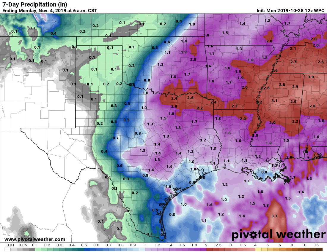 The latest guidance suggests an end to the rain from west to east Wednesday evening, meaning a dry day for the trick-or-treaters on Thursday with the sun returning. However, we will experience the coldest air so far this season as we drop to the 32-36° range early Thursday morning, with potential for a freeze in some spots over North Texas. There could be a possibility of ice on some bridges and roadways during the morning commute for any leftover rain, which will be more of a hazard if rain continues Wednesday evening. We will continue to fine tune this forecast as we get closer to Halloween. FRIDAY AND THE WEEKEND: Very cold air will hang around for the weekend, meaning each day will start in the low to mid 30s. Saturday and Sunday will be dry with sunny, cool days and clear, cold nights. Highs over the weekend will be in the 56-63° range, with lows in the upper 30s. Frost is likely in some isolated spots. NEXT WEEK: Most of next week is looking dry right now with our next chance of rain coming Tuesday, but it is a small chance. See the Texas Weather Discussion Video for more details. 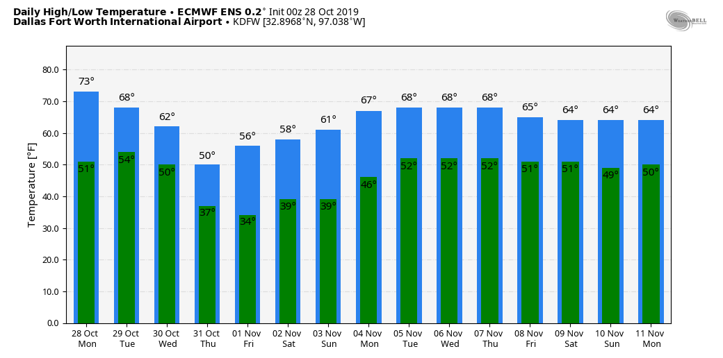 TROPICS: Pablo, a tropical storm in the North Atlantic, will continue to dissipate today. Otherwise, the Atlantic Basin remains quiet. The hurricane season will continue through November 30.
TIME CHANGE: Daylight Saving Time ends this weekend, which means, we will set the clocks back an hour later Saturday night. The sunset time on Sunday, November 3, will be 5:35 PM CST. MORE SUMMER WEATHER: A deep layer of moisture remains over North Texas today, which will result in higher temperatures and higher humidity values, resulting in Heat Advisory conditions. Afternoon highs will be in the triple digits again today with heat indices in the 105-110° range. This will likely be the last day of heat advisory conditions for a long time, if not, the year. TOMORROW AND WEDNESDAY: Our weather turns unsettled with a surface front moving through our area tomorrow, which will spark chances of scattered showers and thunderstorms across the region. Keep in mind that it won't be an all day type rain, just rain at times. There are possibilities for a few stronger storms in the mix with moist air and adequate dynamic support. The SPC has all of North Texas in a "marginal" (level 1 of 5) risk of severe storms tomorrow afternoon to address the potential for gusty winds associated with storms or a few wet microbursts. 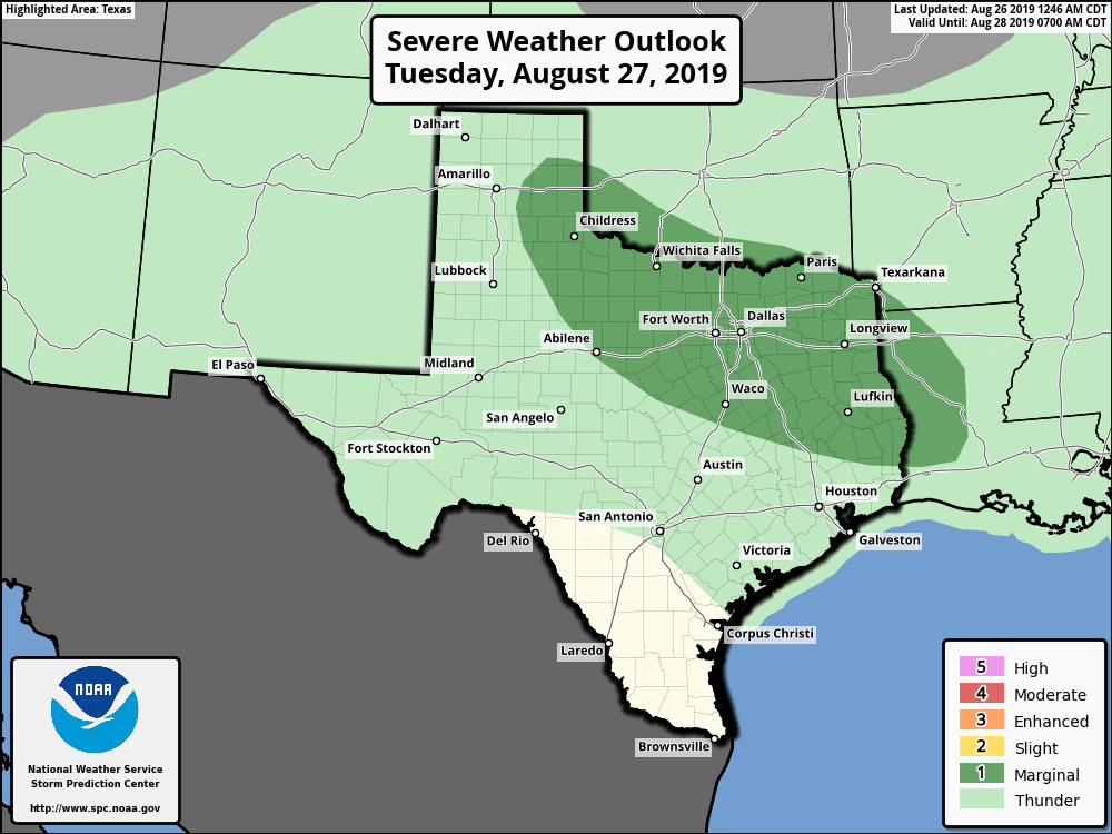 We do not expect any major flooding issues, as rain amounts will range from 1-3 inches in most spots. Some street flooding is possible with the most intense cells, however. There is a good chance that many communities hold in the upper 80s tomorrow because of clouds and rain, although some may reach the low 90s by the afternoon. The weather remains unsettled on Wednesday with showers and storms in the morning. Look for mostly cloudy skies with highs holding in the upper 80s due to clouds and rain once again. THURSDAY THROUGH LABOR DAY WEEKEND: A few storms are still possible through Thursday. Otherwise, we stay dry for most of the region this weekend with mostly sunny skies. Highs will range from 90-96°. The average high for DFW around this time of the year is 95°; we do not expect any excessively hot weather for the weekend. NEXT WEEK: Our first week of Meteorological Fall looks very pleasant with partly sunny days and temperatures just a few degrees below average. Fairly routine weather for early September begins with highs around 90-93°. See the Texas Weather Discussion Video for more details. 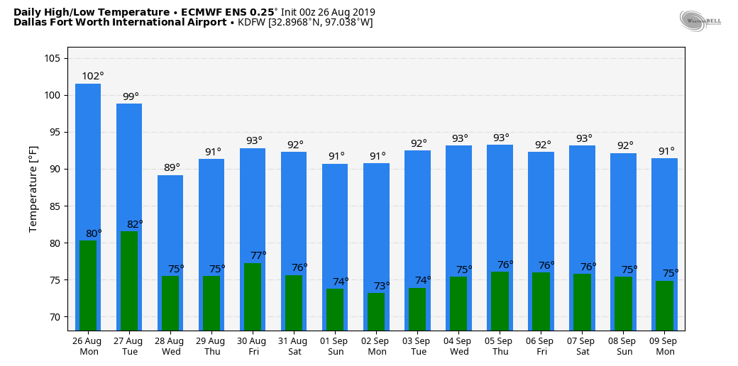 TROPICS: Invest 98L, which is located hundreds of miles to the east of the South Carolina coast, still maintains a high chance of becoming a tropical/sub-tropical storm within the next 24 hours. It will move to the northeast, away from the US. Further south, Tropical Storm Dorian in the Atlantic now has max. sustained winds of 60 mph, and will pass through the Leeward Islands early tomorrow morning. Any intensification will be delayed because of dry air around the system, but the NHC does have Dorian on track to becoming a category one hurricane as it nears the Dominican on Thursday. There is a chance that the mountainous islands and dry air destroys the system before it can move any further northwest, but the NHC moves Dorian through the Bahamas as a tropical depression Friday and the weekend. 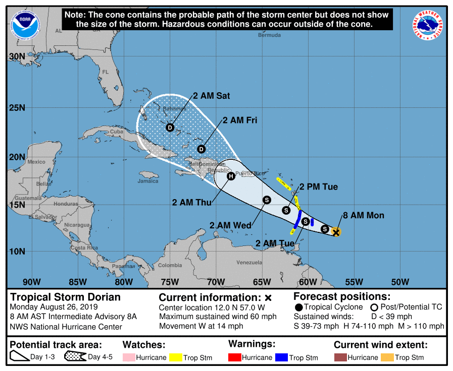 The truth is, it is still too early to determine what impacts the system might have on the US. However, the upper air pattern favors curving the system into the westerlies around the South Atlantic Coast. It will remain far away from the Gulf of Mexico if this happens, but still way too early to determine that. The rest of the Atlantic Basin stays quiet.
RAIN POSSIBILITIES TODAY THROUGH THE WEEKEND: An increasingly moist, unstable airmass will be in place today, setting the stage for occasional showers and thunderstorms this late afternoon through Saturday. It certainly won't rain all day today or tomorrow, or over the weekend, but there is a good chance of some beneficial rains for a good part of North Texas. Most of the rain will come from 7PM this evening through 7AM tomorrow morning, but showers during the day tomorrow cannot be ruled out. Heat levels will come down due to cloud cover and limited amounts of sun. Highs will be in the 94-98° range. NEXT WEEK: We go back to heat advisory conditions for a brief period Monday afternoon, then a surface front bringing another chance of showers and storms moves through here late Tuesday afternoon. The latter half of the week will trend drier and cooler as a long wave upper trough evolves over the eastern third of the US. There is a chance we see drier, continental air during the latter half of the week with lower humidity and cooler nights. See the Texas Weather Discussion Video for more details. 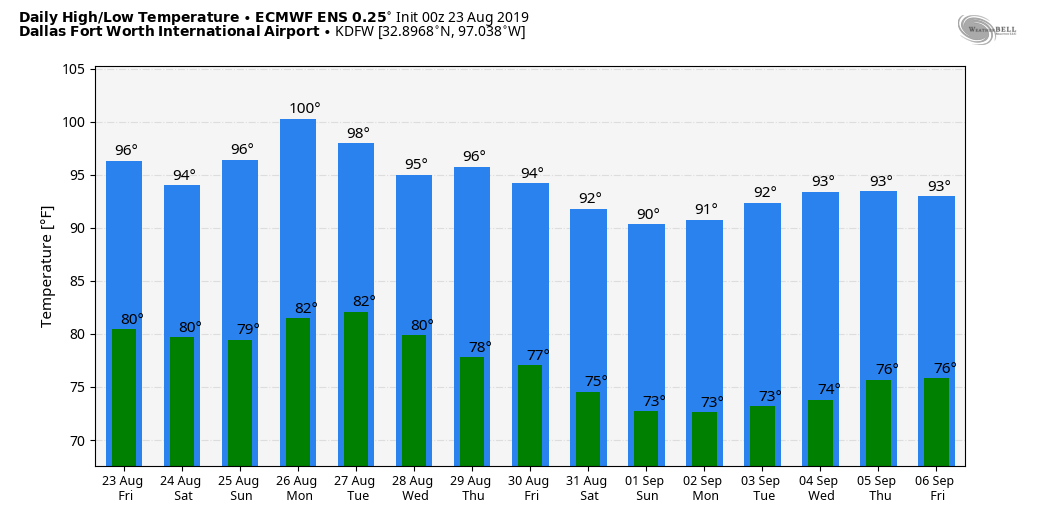 DROUGHT MONITOR: The new drought monitor released yesterday morning shows most of the state in some kind of drought conditions, concentrated over parts of South Texas, expanding rapidly into west Texas. Places like Abilene have gone a full month without receiving measurable rainfall. 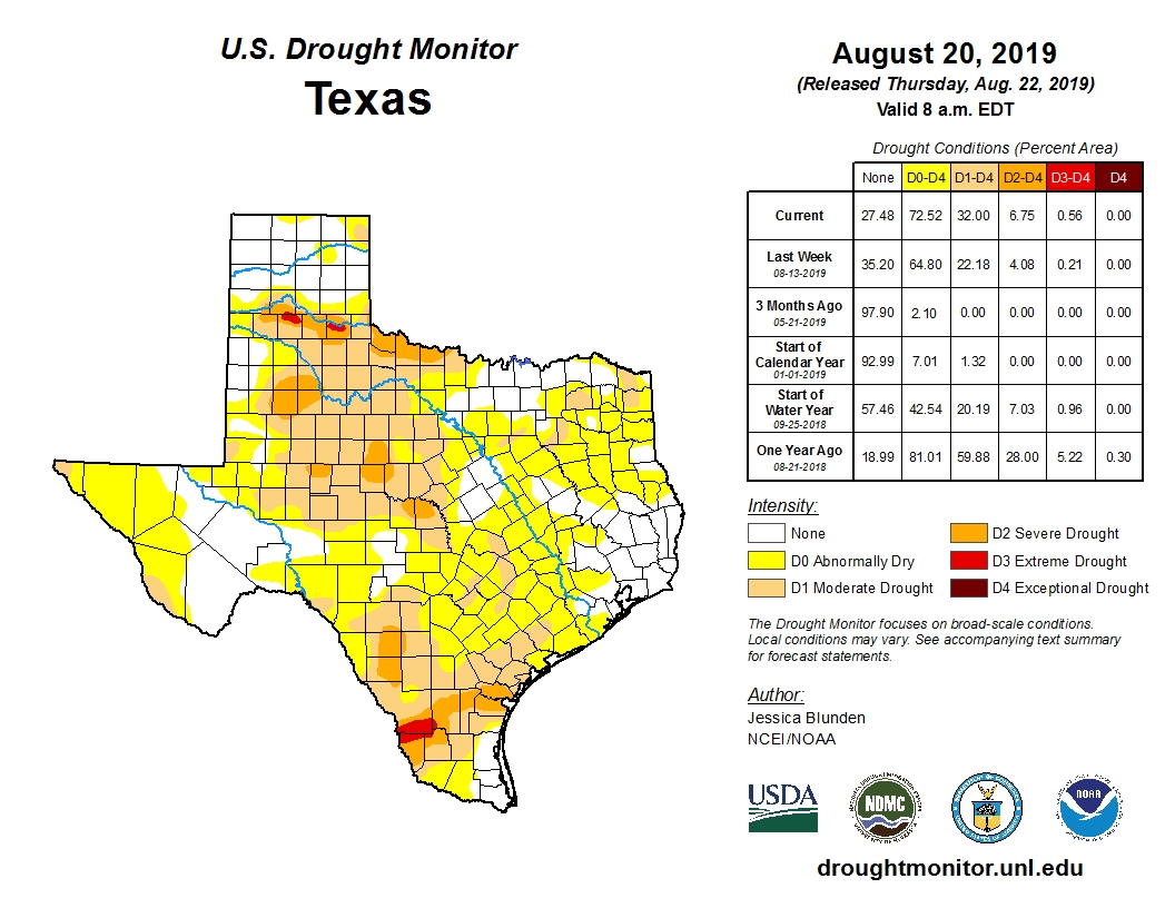 TROPICS: Tropical Depression Chantal is expected to dissipate over the Northern Atlantic within the next 24 hours. A tropical wave over the Bahamas now has a 50% chance of becoming a tropical depression or storm over the next five days; it will move north, then northeast just off the Southeast US coast. No threat to the Gulf of Mexico. 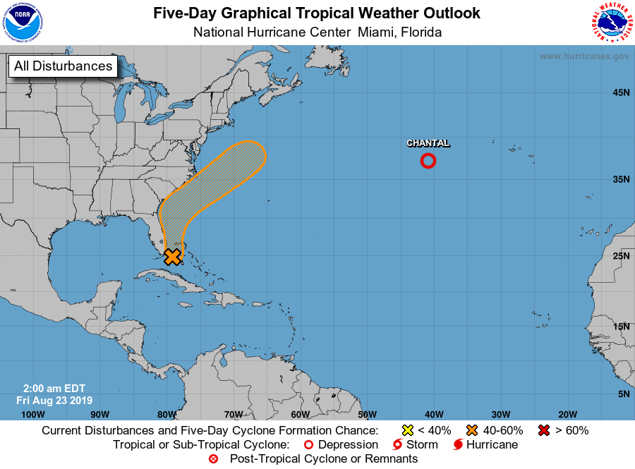 After a drizzly, foggy, and mild day across much of North Texas, heavy rains will follow suite tomorrow afternoon through Thursday. Some spots of NTX could receive 1-2” of rain with isolated higher totals up to 4” possible, mainly north of DFW.
Temperatures will be mild tomorrow in the 70s, but Thursday will be much colder. Morning temperatures will start in the 60s before falling through the 40s in the afternoon with rain coming to an end from west to east. Lows Thursday night will be in the 30s, with highs Friday only in the 40s and 50s. Some patchy frost is possible. The weekend will be warmer will highs rebounding into the 60s and possibly the 70s by Sunday. Dry weather is expected. A strong front will roll into NTX sometime on Monday. The timing of this front is uncertain, but it appears likely for rather widespread precipitation. As the cold air settles in Monday into early Tuesday, we will watch for a threat of wintry precipitation. Right now, the forecast is uncertain on what happens during this timeframe. It does bear watching since some ensembles and models do hint at a more significant wintry weather event. Highs will be much colder Monday, likely falling through the day. Temperatures will likely be in the 20s Monday night, struggling to reach 40° by Tuesday with sunshine returning. Again, the overall pattern is uncertain. The set up does favor some sort of wintry precipitation, but exactly how cold it can get is very uncertain as of now. Therefore, opted to keep a very low chance of a wintry mix during this timeframe. Stay tuned for updates the next few days as we get a better handle on this system. A gradual warm up will take place later in the week, finally reaching the 50s by mid to late week. Dry weather is expected beyond Tuesday. Logan Shipley ANOTHER CLASSIC SUMMER DAY: This is honestly what we expect in summer in Texas. Another day of classic summer weather with lots of heat and humidity is expected with highs basically at the century mark. I know this is basically the same forecast over and over and over again, but I promise subtle change will come over time. But for now, another Heat Advisory remains in effect for this afternoon, so you can expect another afternoon with heat indices in the 105-110° range. Not much change tomorrow. Although we might not quite hit the century mark tomorrow, the humidity levels will increase, so it will still feel just as hot as the past few days. Mostly sunny skies are still forecast. FRIDAY AND THE WEEKEND: A weakness in the ridge will allow for a surface front to attempt to push through the region Friday night, when we will introduce a chance of isolated to scattered showers and storms beginning Friday evening, lasting through Saturday during the day. Not everyone will receive rainfall. Look for a mix of sun and clouds each day. Heat levels will be slightly lower due to increased cloud cover. Highs will be in the 95-99° range. NEXT WEEK: We will briefly continue to maintain our hot pattern for the beginning part of next week as the upper high continues to dominate our region. There is evidence of a pattern shift for much of the Central Plains by the latter half of next week, which would allow a surface front to move through the region by Wednesday or Thursday, allowing for greater chances of rain and a cooling trend. But expect routine summer weather conditions before any of that. See the Texas Weather Discussion Video for more details. 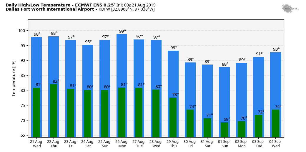 TROPICAL STORM CHANTAL FORMS IN THE NORTHERN ATLANTIC: Rapidly developed, Chantal is a tropical storm in the Northern Atlantic, away from land. It is expected to stay far away from any land, continuing to meander in the North Atlantic until it becomes post-tropical this weekend. The rest of the Atlantic Basin remains quiet.
SUMMER WEATHER CONTINUES: Look for hot and humid weather again today across North Texas with a partly sunny sky and afternoon temperatures in the 100° range. Like yesterday, the heat indices will be in the 105-110° range this afternoon with a nice, upper-level high parked right on top of us. A Heat Advisory remains in effect for most counties in North Texas. Some counties to the west have been trimmed away from the advisory, but just realize that everyone will remain very hot for the time being. The weather won't change much tomorrow as the classic summer pattern continues. THURSDAY THROUGH THE WEEKEND: The upper high pattern will still persist. However, weak impulses from the High Plains and parts of the Central Gulf Coast will keep much of the region dry for the rest of the work week. However, the abundance of the impulses will work to slowly weaken the ridge parked over us, and temperatures should fall in tandem to the weakness of the ridge. Highs will be in the upper 90s for Thursday and Friday, followed by mid 90s for the weekend. The weakness will allow for a surface front to drop into the region by Friday, allowing low chances of spotty showers and storms mainly Friday night through Saturday morning, but also during the day on Saturday. We stay mostly dry on Sunday, and each day should be filled with mostly sunny skies and subtle increasing cloud cover. NEXT WEEK: The last week of August features seasonal temperatures with the main upper level ridge well to the west of us by Friday. Highs will be in the mid 90s all week, but we end up at around 90-93° by Friday with lows in the mid 70s. See the Texas Weather Discussion Video for more details. 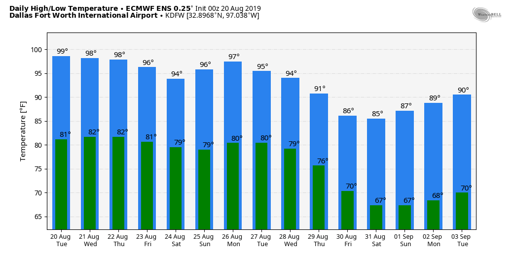 After a beautiful Friday across North Texas, your Saturday will remain much of the same. Highs in the upper 50s to mid 60s with partly cloudy skies. We warm up a bit by Sunday, into the upper 60s and lower 70s. Dry weather is expected for the weekend.
Things begin to change by Monday. A strong cold front will be located in the Midwest and northern/central plains, and will be progressing southward towards Texas throughout the day. We will see somewhat of a setup for compressions warming, into the low to possibly mid 70s during the afternoon. A few isolated to scattered showers and thunderstorms may develop. No severe weather is expected, but small hail and gusty winds will be possible in a storm or two. The front will be on top of DFW likely during the evening, and a strong upper level low will be moving out of the Baja of California/far southern four corners region. As it does so, temperatures will be falling into the middle 30s with widespread showers. At this point, some snow may begin to mix in as well as sleet. There may be a chance of a complete changeover to snow showers through the morning hours on Tuesday. The European is the most aggressive on this solution, keeping snow around into the early afternoon with temperatures struggling to get out of the 30s. The GFS is a bit more progressive, and has some wintry weather around 4am till around 10am before moving out, allowing us to reach the low to mid 40s during the afternoon. The European solution would favor a low chance of some accumulation as well on grassy surfaces of up to 1/2” of an inch. The GFS has no accumulation. For now, will side with the GFS and have a chance of a rain/snow mix Tuesday morning with no accumulation threat. The key takeaway from all of this is: WE WILL BE ABOVE FREEZING THE ENTIRE TIME! This should keep road impacts to a minimal. Also, keep in mind we are still 3-4 days out and a lot can change. This is NOT set and stone, but just be mindful that there may be a chance for some snow on Tuesday. We will gradually reach the 50s by later next week, with another weak front arriving for the weekend, keeping cool temperatures with highs in the 50s and lows in the 30s. NOT AS HOT: As advertised, heat levels are slightly down over parts of the state this morning. Temperatures are only in the mid to upper 70s this morning, which is a big contrast from yesterday morning. We will mention temperatures right at seasonal averages for this time of the year with highs in the upper 90s with a mostly sunny sky. TOMORROW THROUGH THE WEEKEND: Winds will turn south today and tomorrow, drawing in rich moisture from the Gulf of Mexico. Combine that with the already high temperatures and humidity levels and we will likely bring back hotter days with oppressive heat indices for the weekend and beyond to serve as a friendly reminder that we are still in the middle of the dog days of summer. Highs will mostly be in the upper 90s for all three days with overnight lows in the low 80s. NEXT WEEK: The overall pattern favors several days of Heat Advisory conditions for much of the region. The same hot, humid, and dry weather conditions continue for much of next week with little to no change in the forecast. See the Texas Weather Discussion Video for more details. 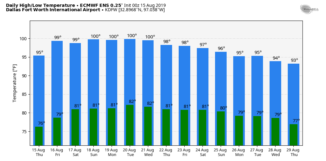 TROPICS: Although tropical cyclone development is not expected through next week, we are watching a potential system that may try to make a run in the Gulf and try to stir some trouble next week. However, confidence is too low to warrant any chances of development. The rest of the Atlantic Basin remains quiet.
RADAR CHECK: As advertised, a surface front bringing the chance of scattered showers and storms is moving through parts of North Texas, mainly moving to the northeast. The most you will get out of these is lightning and heavy rain, and no severe weather is expected. Most of these storms will likely dissipate by the afternoon hours today.  The front will continue to push slowly south through the rest of Texas today and tomorrow, and drier air moves into the state later today, and the day should feature a mix of mostly clouds and sun with highs in the mid 90s with just a tad lower humidity levels. We dry out tomorrow, it will be a mostly sunny day with lower humidity and slightly lower temperatures. Highs will be in the mid 90s with a very calm southeasterly wind. FRIDAY AND THE WEEKEND: The weather is looking dry with mostly sunny days and fair nights. Highs will be mostly in the upper 90s, with nighttime temperatures somewhat cooler with early morning lows in the mid to upper 70s. NEXT WEEK: Dry weather will continue throughout most of the week, but highs will hold right at seasonal averages for this time of the year as moisture levels rise. See the Texas Weather Discussion Video for more details.  TROPICS: Atlantic Basin stays very quiet this week, and no new tropical cyclones are expected.
WARM MORNING: Temperatures are generally in the 82-85° across most places in the region this morning with mostly fair skies. We have some good, soaking rain in Oklahoma and around Wichita Falls this morning. It is moving slowly; and will dissipate during the late afternoon/evening. ONE MORE VERY HOT DAY: A "Heat Advisory" remains in effect for all of North Texas today. Temperatures won't be much different from the past couple of days; highs should be in the 100 degree range, but humidity values past 50% could push heat indices to around 110° again this afternoon. The record high for DFW today is 105° set in 1951, which should be safe. The average high for August 13 is 97°. TONIGHT/WEDNESDAY: A surface front will approach tonight, and isolated to scattered showers and storms could invade our northern counties as early as this late afternoon/evening. Then, tomorrow morning, we will have a good chance of scattered showers and storms for a good portion of the region. Understand that we can not promise rain for everyone, but any one spot stands a 40/50 percent chance of getting wet, especially during the pre-dawn hours. We also note that the SPC has a "marginal risk" of severe storms (level 1 of 5) defined for the DFW Metroplex and points to the north; some of the storms could produce wet microbursts and strong, gusty winds. 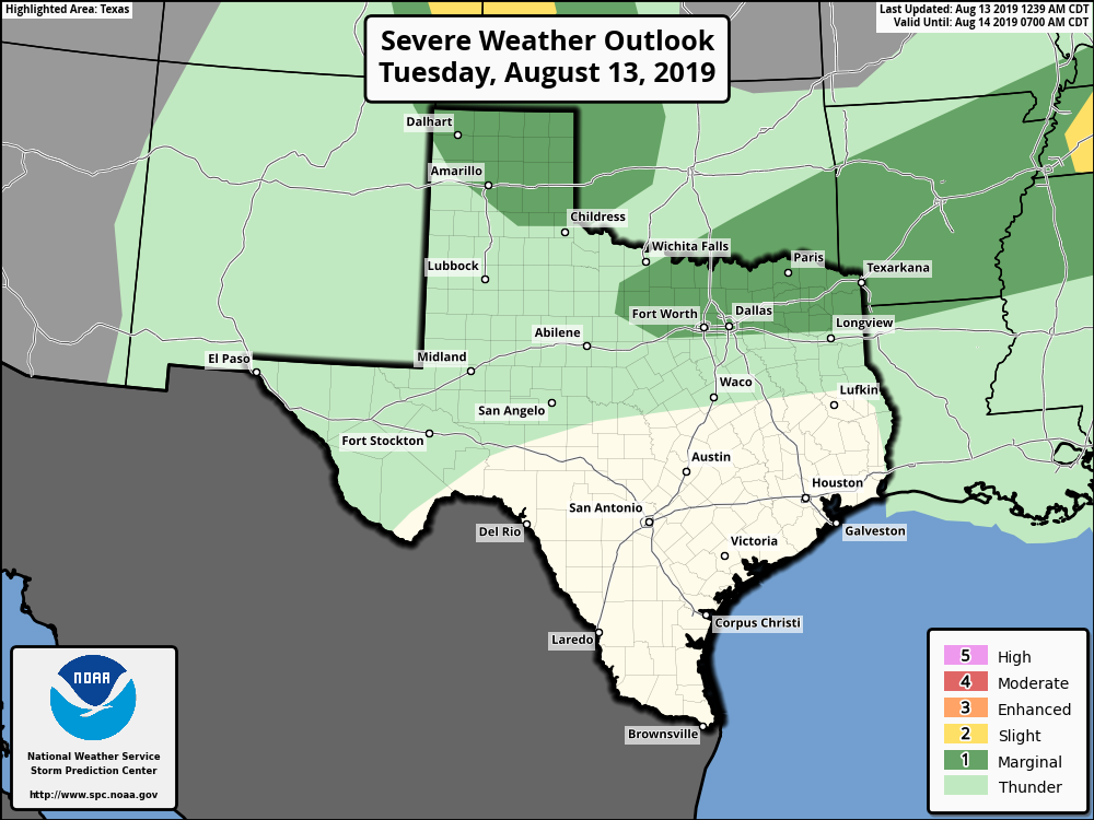 THURSDAY THROUGH THE WEEKEND: The surface front is expected to make it all the way to South Texas tomorrow night, and it looks like much of the stay will be dry for Thursday through the weekend. This means mostly sunny skies, lower humidity levels, and cooler nights. Highs will be in the mid to upper 90s, and lows in the upper 70s. NEXT WEEK: The upper high pattern rebuilds over North Texas next week, but will not be as strong as it is now. Highs will be in the upper 90s with lows in the upper 70s/low 80s. 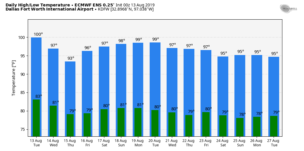 TROPICS: The Atlantic Basin remains quiet once again, and tropical storm formation is not expected through the week. There are only two occasions that the Atlantic has had zero named storms between July 15 and August 15: 1999 and 2015. 1999 was still an above-average season while 2015 was below average.
ALREADY FEELS LIKE A SPRING AFTERNOON: Temperatures are mostly in the middle 80s this morning across North Texas, which would probably be our high temperature if we were in April. We project highs to be above 100° again for the region with heat indices around the 110° area. A Heat Advisory remains in effect for all of North Texas, but an Excessive Heat Watch is in effect for the DFW Metroplex and for areas to the east of US 281. How today goes will determine if we stick with a Heat Advisory or issue an Excessive Heat Warning for some areas. Not much change is expected tomorrow. We will be a few degrees hotter with highs around mid triple digit range. MIDWEEK: A mid-August cold front sweeps through here by late Tuesday night, which will bring the chance of scattered showers and storms through Wednesday morning. Not everyone will see rain, as the best chance of a spot getting wet is only one in three. But the good news is we will not be baking as much. Highs will be in the mid 90s for a couple of days, which is near our seasonal averages. FRIDAY AND THE WEEKEND: Unfortunately, we will go back to our same prolonged hot and dry pattern as before, except the upper-level high will not be as strong as it is now. It will still be very oppressive with highs in the upper 90s, but dewpoints will make it feel like 100-105°. Another Heat Advisory will likely be needed to address this potential. NEXT WEEK: Another week of prolonged hot and dry weather is expected with highs in the upper 90s for most of the week with overnight lows in the upper 70s. We begin to cool down towards the end of the month with temperatures regularly in the mid to low 90s. See the Texas Weather Discussion Video for more details. 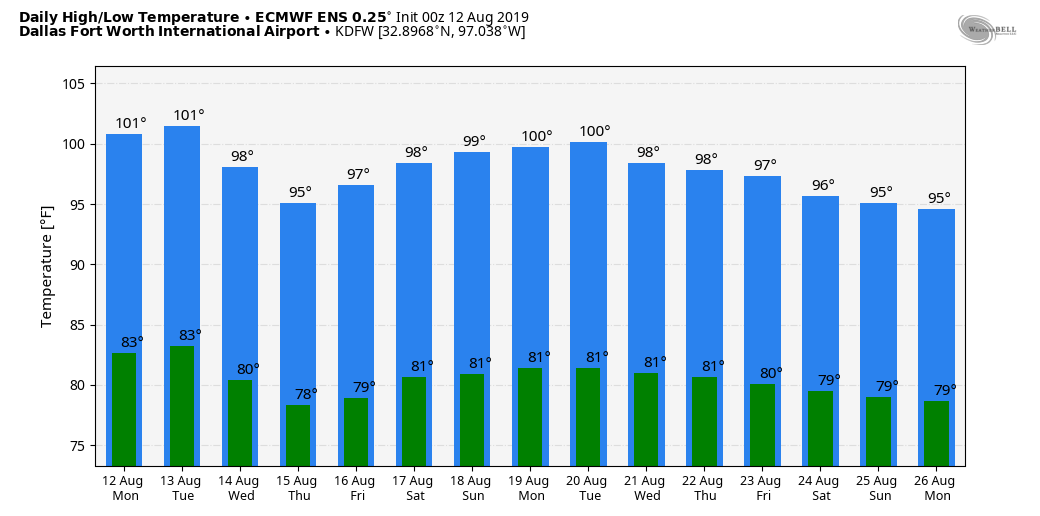 |
Archives
April 2024
Categories |
 RSS Feed