
|
MILD START - Temperatures are in the mid 50 to low 60 degree range for much of the region this morning. Don’t expect much sun this week, our current upper air pattern shows a trough pushing down to the south near California, advecting moisture to the north, which will spark our rain and storm chances. We will reach the low 80s today with mostly cloudy sky and breezy conditions. We will mention the chance of a few showers during the day, but nothing widespread. Tonight will be generally overcast with lows in the mid 60s. THE REST OF THE WEEK - A trough in the southwestern states and a deep surface low in Colorado will spark our first major severe weather chances of the season. For now, we will mention cloudy days and mostly overcast nights with highs in the low to mid 80s each day. We will mention the risk of a few showers and thunderstorms each day, but our main event won’t come until Thursday, despite a major severe weather threat in place for the nation’s heartland on Wednesday. 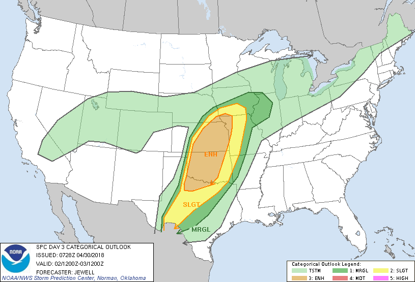 We will mention the chance for scattered showers and storms during the day on Wednesday, but I don’t anticipate any major severe weather issues for North Texas. Our main threat of rain starts Thursday during the pre-dawn hours and lasts through most of the day, according to the GFS. Once that activity moves off to the east on Friday, we should be dry with clouds still in place. Again, we will still continue to mention rain at times. THE WEEKEND - We will continue to mention the risk for occasional showers with a few clouds in place. The weekend looks generally dry with highs in the mid 80s. NEXT WEEK - Next week looks mostly sunny and dry with highs in the mid 80s.... see the Texas Weather Discussion Video for more details. 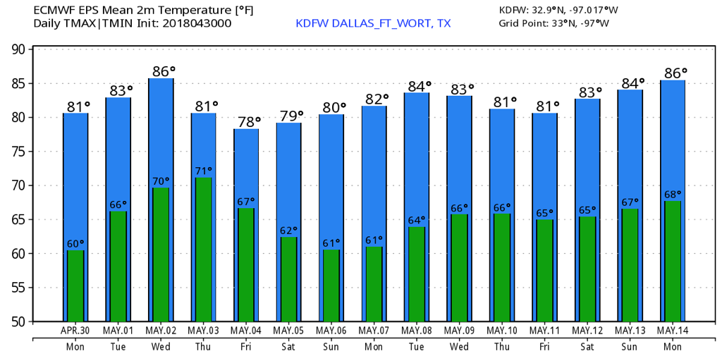 COMFORTABLE START - Temperatures are mostly in the mid to upper 50s across the great region of North Texas this morning, which is about average for this time of the year. That upper low and front that produced rain on Wednesday is well off to the east, and we should continue to feature pleasant days with abundant sunshine with highs in the upper 70s. Some places might reach 80 today. THE WEEKEND - The weekend outlook looks absolutely perfect for any outdoor activities. The sky will feature abundant sunshine with a few clouds at times. Highs will be in the low to mid 80s though, so it will be quite mild, but dry. Be sure to get any outdoor acitivties in this weekend, because rain and storm potential will increase next week. NEXT WEEK AND BEYOND - The first two days of next week look mostly dry, though clouds will most likely overspread the region as the flow of low-level moisture starts to increase. Our real chances of scattered showers and thunderstorms begin Tuesday and Wednesday with a classic triple--point setup in Oklahoma and Kansas. Those rain chances for us will continue through Friday morning. Highs will mostly be in the mid 80s during the week. Next week will also be more active in terms of our severe weather season (or lack thereof). The SPC has parts of the plains in a risk of severe weather everyday until Thursday. 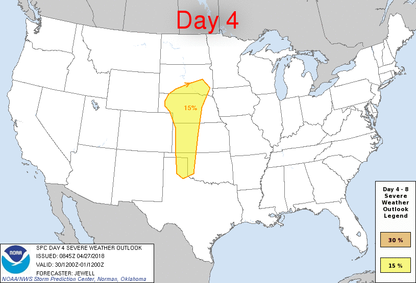 Each day will feature at least some risk for severe thunderstorms, including the potential for supercells, especially on Wednesday over parts of Central Oklahoma and Kansas. I'm already starting to see the 'o' word being thrown around social media. At this time, it is too early to specifically forecast any severe weather hazards. Just know that all modes of severe weather will be possible, including the potential for large hail and a few tornadoes. Also recognize that it is also too early to describe exact placement, and timing, and all of those details will be refined over the weekend. But the good news is that we can expect to see more precipitation over the next two weeks. The Climate Prediction Center calls for above average precipitation values for parts of Texas extending into the lower Ohio Valley. See the Texas Weather Discussion Video for more details. 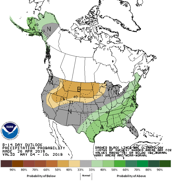 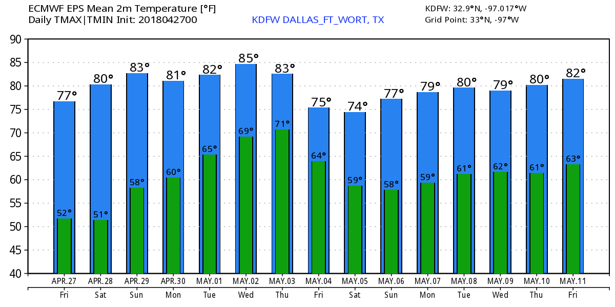 ON THIS DAY IN 2011 - Today marks the 7th anniversary of the generational tornado outbreak of April 27, 2011. This was the deadliest High Risk Day on record; the event set record for the most tornadoes recorded in a 24-hour period. Also included a 45% tornado area which is above the minimum threshold for a high risk. Also produced the only known watch (Particularly Dangerous Situation (PDS) Tornado Watch 235) with a >95% of all severe and significant hazards. 218 tornadoes touched down; Four were rated EF5. In addition to 317 deaths, over 2000 were injured.
*No Texas Weather Discussion Video this morning* CHILLY START - As expected, temperatures are in the low to mid 40s this morning with some of the naturally colder spots in the 30 degree range. Thankfully we won't stay like this all day. Temperatures will rise to the mid 70s under a mostly sunny sky. This will be the case for the rest of the week through the weekend. Each day will feature cool nights and pleasant days. We start off in the low to mid 50s, ending up in the mid 70s Friday afternoon. A warming trend will begin to take place, and we should be in the low 80s during the weekend. NEXT WEEK - Next week's weather gets a little interesting to deal with. The early part of next week looks mostly dry with a mix of sun and clouds and a southerly wind. Moisture starts to feed in from the south which will set up for multiple rain and storm chances during the week. It looks like we will also having a shot of seeing our first severe weather threat of the actual season, but nothing to indicate an outbreak. We will warm to the mid to upper 80s during the week. 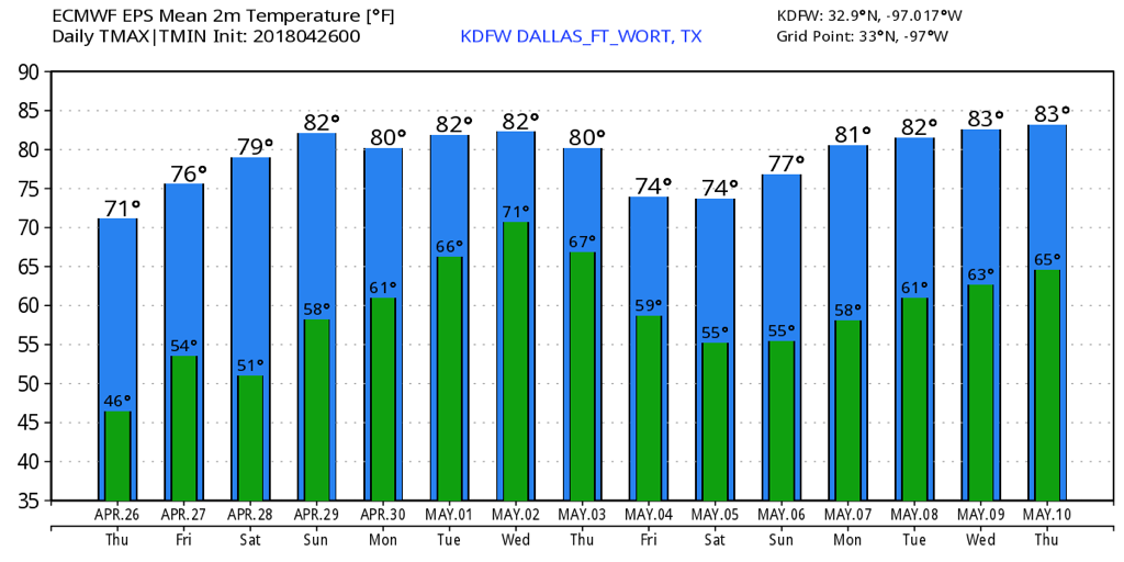 RADAR CHECK - Showers and thunderstorms are off to the west of the North Texas region this morning... 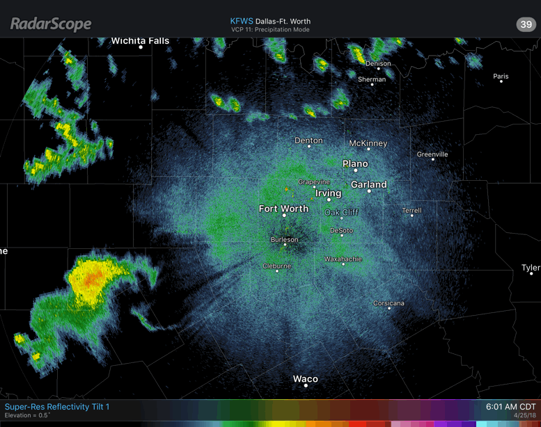 We will start to see these rain showers progress to the east with time, and rain will still be possible during the morning hours. Our best chance of widespread rain will come during the afternoon hours after 3PM. Luckily, no severe weather is expected today, and rain amounts should stay under 1/2 inch, which is not enough for any flooding concerns. We are mostly in the mid 60s right now, and that will be our high temperature for today. Once the cold front comes through, most places will stay where they are at or fall a couple of degrees during the afternoon. The rain clears to mostly sunny skies tomorrow with afternoon highs in the mid 70s. We start the day in the mid to upper 40s, though. FRIDAY AND THE WEEKEND - Dry air rolls in here by Thursday, which will set up for a pleasant weekend ahead. Highs will be in the mid 70s on Friday and Saturday, warming up to around 80 on Sunday. NEXT WEEK - A trough sets up to the west, which will allow moisture to advance northward, making for a cloudy and rainy week. Thunderstorms are possible during the latter half of the week, but it remains unknown whether or not we see any significant severe weather. See the Texas Weather Discussion Video for more details. 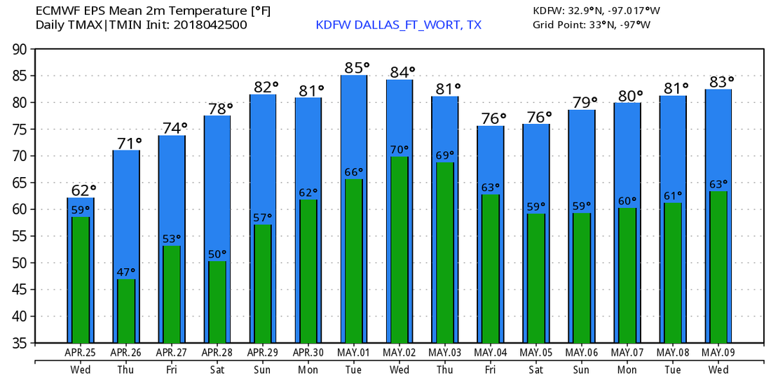 ON THIS DATE SEVEN YEARS AGO: The four day “superoutbreak” of tornadoes, which lasted from April 25-28, 2011, would begin. By the evening hours of April 25, 2011, multiple tornadoes had been reported across a few states west of Alabama, some of which caused significant damage in Arkansas. An intense supercell thunderstorm tracked near the Little Rock area and a tornado emergency was declared for the city of Vilonia. A large EF2 wedge tornado struck the town, subsequently causing severe damage and killing four people. A strong EF3 tornado had also struck the Hot Springs Village area earlier that evening; that tornado caused severe damage and resulted in one death. Later that evening, Another EF2 tornado caused extensive damage to both a school building and Little Rock Air Force Base as well. A total of 42 tornadoes and four tornado-related deaths were confirmed on the 25th.
LOOKING UP - The deep upper surface low that brought heavy rain and severe storms to parts of North Texas this weekend is over Tennessee this morning. The heavy rain and thunderstorms is well off to the east of us and is affecting parts of the Carolinas and the east today. Today will feature a sunny sky with a afternoon high around 82 degrees. MIDWEEK - Scattered showers will remain possible tomorrow as a cold front comes through during the afternoon. The good news is, this will be mainly in the form of rain showers, so no severe weather is expected and not much thunder is expected, either. Just a classic rainy afternoon across the region. We turn breezy and cooler during the day with highs only in the mid 60s during the afternoon. We should go back to mostly sunny skies on Thursday with highs in the mid 70s. FRIDAY OUT - Looks like the magic day plus the weekend will turn out pleasant and dry with lots of sunshine and pleasant nights. The high on Friday will be in the low to mid 70s, warming up to around 80 during the weekend. NEXT WEEK - For the first week of May, most of the week looks mostly cloudy and dreary with a chance of occasional showers and thunderstorms, especially during the latter half of the week with highs in the low 80s. We will need to monitor the potential for severe weather in the southern and central Plains, especially during the latter half of the week going forward. See the Texas Weather Discussion Video for more details.  The rest of the day will feature partly sunny skies with temperatures in the 70s, and tomorrow will be the same but highs will reach the 80s.
By Wednesday, a disturbance and cold front will bring a chance of showers to the region. This doesn't appear to be widespread rain or any severe weather. Only 30-40% of North Texas will pick up measurable rainfall, with the better chances along the Red River counties. Highs will be in the 60s across the area. Rainfall totals will generally be less than 1/4" of an inch, but it's not ruled out for a higher amount or two in an area that receives a thunderstorm. Instability will be so limited that I don't expect much storm activity, but spotty to possibly scattered showers are in the forecast. We will be cool on Thursday with highs in the 70s with partly sunny skies. Friday and Saturday will be the same. We with reach the 80s by Sunday with a low 20% chance of an isolated thunderstorm or two west of I/35. Most if not all areas will remain dry. Monday will be warm with highs in the 80s under partly cloudy skies. Again, a low 10% chance of a storm is possible. By Tuesday and Wednesday, some decent storm chances look to possibly return. Medium range data continues to support a severe thunderstorm potential during this timeframe. Jonathan Williams Meteorologist Storm Specialist NWS/NOAA Ambassador *No Texas Weather Discussion Video this morning* CHILLY START - Temperatures are in the mid 40 to low 50 degree range across the great region of North Texas this morning. Expect a nice warm up this afternoon with a few clouds. Highs will be in the mid 70s. Clouds exit the area on Tuesday, and we warm up during the afternoon with highs in the low 80s with abundant sunshine. MIDWEEK - A cold front is due in here during the pre-dawn hours on Wednesday, and scattered showers and storms will accompany that front. It certainly won't be raining all day, but rain is possible at times during the afternoon and evening. Fortunately, severe weather is not expected, just a classic rainy afternoon and evening here in North Texas. Rain amounts should stay under a half an inch in North Texas. Highs will only reach the mid 60s in the warmest spots. Rain clears to mostly sunny skies for the rest of the work week, and highs should be in the low 70s. THE WEEKEND - Not much change. We turn milder for the weekend, and highs will be in the upper 70s. Some places might hit 80, but that's more likely on Sunday. NEXT WEEK - The first few days of May looks reasonably dry, though we may deal with a few isolated storms at times. We project highs in the low to mid 80s under a mix of sun and clouds. No sign of any significant severe weather event anytime soon.  DID YOU KNOW? - So far, Oklahoma has survived this April without any tornadoes being recorded anywhere in the state. If we keep this up for the next week, this will be the first time Oklahoma hasn't had a tornado in April since records have been kept. We are clearly below average in terms of the number of tornadoes nationwide.
Today has started off with some sun, but some storms are off to the west and are moving northeast. Some have produced some hail. Basically, if these storms impact the DFW area, it *may* lower the overall severe potential along the cold front this evening. I am growing uncertain that these storms will affect the DFW area, which may increase the severe potential. Why will morning rain affect severe potential? Because it may or may not stabilize our atmosphere a bit. Either way, it won't be zero even if we see some rain this morning. If we see rain, the threats will be:
Penny to Quarter Size Hail 50-60mph Winds Lightning Very Heavy Rain IF we don't see rain, the severe threats are: Quarter to Golf Ball Size Hail 60-70mph winds A tornado or two Torrential Rain Lightning I'll keep you updated through the day! ANOTHER DRY, PLEASANT DAY AHEAD - Temperatures are in the mid 40 to mid 50 degree range across the region, and today will be a few degrees cooler than yesterday with a high around 70 degrees with a southeast wind of around 10-15mph. Clouds will increase throughout the day with an approaching cold front and rain out in West Texas. Then tonight will become overcast as clouds roll through with overnight lows in the low 50s. RAIN/THUNDERSTORMS SATURDAY - Saturday looks like a very wet day as a low pressure area will move into the west Texas, passing to the southeast during the day. Rain should begin during the morning hours at around 7 to 8am in the North Texas area. We could see a break in the rain during the afternoon, but then a few thunderstorms are possible during the evening as a second band of rain is likely. It must be noted that the SPC has outlined a "marginal" risk for severe storms for all of North Texas and areas to the north of the Red River.  Storms should remain very isolated in coverage, and this will not be a widespread severe weather event. But with the few storms that do end up turning severe, we could see some produce some large hail at times. Also, I wouldn't completely rule out the possibility of a brief tornado with the strongest cell. Thunderstorms should develop pass 6P, tapering off to the east during the overnight hours. The high will be at around 67. Once the activity pushes off to the east, that will give off to a dry day on Sunday with afternoon highs in the upper 60s. It will still be cloudy though. NEXT WEEK - The early part of next week looks dry. A cold front will move through on Wednesday, and that could set off the possibility of scattered showers and storms. We then warm substantially to the low 80s during the latter half of the week. See the Texas Weather Discussion Video for more details.  ANOTHER WARM DAY - With a clear sky, we project a high around 75 degrees for much of region, just a couple of degrees below average for mid April. Then tonight, we fall to the mid to upper 40s before we reach the low 70s again by Friday. Cloud will increase Friday due to a cold front coming through during the weekend. THE WEEKEND - Prepare for a wet and muggy day on Saturday with rain likely during much of the afternoon and evening. Luckily, severe weather is not expected and rain amounts will stay in the one to two inch range, so flooding will not be a concern either. The air will also be pretty stable with highs around 64 with the surface low passing to the southeast. Just a good ol' classic rainy day. That activity pushes to the east Saturday night, and Sunday should be filled with lingering clouds with afternoon highs around 70 degrees. NEXT WEEK - Most of next week looks dry with highs in the mid 70s. Our next cold front is due by Wednesday and Thursday, and that could set off our next chance of showers and thunderstorms. See the Texas Weather Discussion Video for more details. 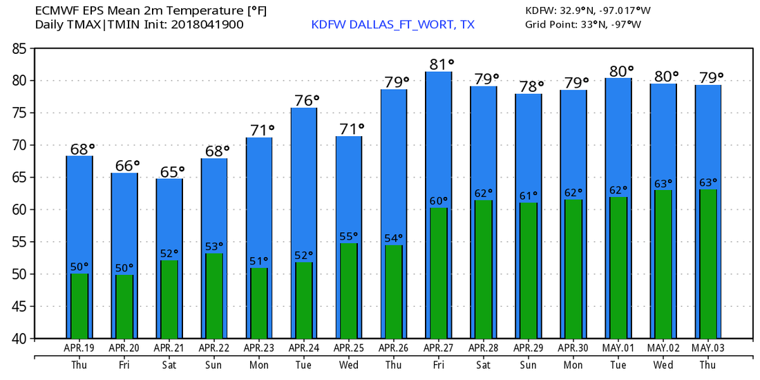 COMFORTABLE MID-APRIL DAY - Temperatures are in the mid 70s range across north Texas this afternoon with sunshine in full force without a cloud in the sky. A cold front came through earlier this morning, all of the state was dry due to little to no moisture, and most places will continue to stay dry for the rest of the day. THURSDAY AND FRIDAY - Thursday will be a sunny, pleasant day with highs in the mid 70s once again. We fall to the low 50s during the overnight hours, and we should be around 70 degrees by Friday afternoon. THE WEEKEND - Once we get through Friday, we turn wet and muggy on Saturday. The GFS continues to indicate rain moving through North Texas all throughout the day, with the best chance of rain during the afternoon and evening. Thunderstorms could try to develop here, but some of the stronger storms could turn severe in Central Texas, especially where the SPC has defined a risk of severe weather for areas near and south of Waco, Temple, and Killeen.  We will most likely have a classic rainy day in North Texas because of the positioning the surface low with some thunderstorms possible. Rain amounts of 1-2 inches are likely during the day. Highs will be in the low 70s/upper 60s during both days. NEXT WEEK - Another cold front passes through during the middle of the week, but most likely in dry fashion. We stay dry and quiet with highs in the 70s. See the Texas Weather Discussion Video for more details. 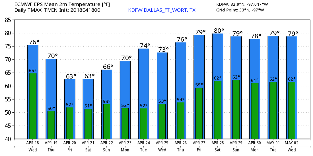 I had a nice time during my four days in Corpus Christi with my band, a vacation I needed for a long time! We will be back on normal schedule tomorrow. Therefore, expect the next video and blog update around 7:00AM!
Today will be a pleasant day across the area, with highs near 80°F. Sunshine is expected to prevail throughout the day. A few clouds are possible late this afternoon and into the evening hours. Overnight, we are only expected to fall into the upper 50s &a lower 60s.
By tomorrow, a weak boundary will be approaching the metroplex. Moisture will be around, but other features to produce storms will be lacking. I have a dry forecast, but some cumulus fields may develop along and south of the boundary. Behind the front, gusty northerly winds will pick up and winds may gust as high as 40mph across the region. This front won't have much affect on temperatures, and we will soar to the mid to upper 80s across the area. Our western counties will have an elevated fire danger, but with recent storms on Friday, this should migitate the overall potential of widespread fire danger. On Wednesday, sunshine and mice temperatures will be in play with highs in the mid-upper 70s with a few 80°F readings possible. Thursday will be the exact same, but some more cloud cover will be in place. A cold front, dryline, and a strong shortwave will move towards Texas on Friday. Showers and thunderstorms are expected to break out in West Texas, and some of those storms map produce large hail and damaging winds. By fridya evening, scattered showers and possibly a few storms will be around in the DFW area. Cloud to ground lightning and brief heavy rain will be the primary threat in DFW. Early Saturday, the dryline and cold front will still be west of the DFW area. Showers and a few storms will be around in DFW, with more numerous activity west of us. By noon, scattered storms will be in DFW, but again, more numerous activity will be along and west of I/35. Some storms may be severe with large hail and damaging winds. By late afternoon into early evening, a squall line of strong to possibly severe storms will be in the DFW area. Damaging winds and large hail will be the primary risks with steep lapse rates and decent shear, and the directional shear may be just enough to produce a low-end tornado risk. The guidance yesterday suggested that CAPE will be near 500-1500 J/kg, and today's guidance suggests CAPE values near 1500-2500 J/kg across the area. A more "significant" severe potential has developed due to a rapid increase in instability. We will watch this closely. A few showers are possible Sunday, but we dry out by Monday. After a cool day today, tomorrow through Thursday will be warm with highs in the 80s, with mainly sunny skies but some clouds return into the middle part of the week.
By Friday, a strong cold front and dryline will be heading eastward into Texas. A few strong to marginally severe storms are possible in West Texas Friday, and this doesn't appear to be a major severe weather outbreak. A few storms may produce up to half dollar size hail and 60+mph wind gusts. By Friday evening, scattered showers and storms will be around in DFW with a few storms capable of heavy rain, lightning, pea size hail, and 40-50mph wind gusts. The severe risk will still be west of our area, but limited instability will migitate the overall risk of severe weather across the area. I can't completely rule out a storm with quarter size hail or 60mph wind gusts in DFW, but it seems quite unlikely. The cold fromg/dryline combination will still be west of the DFW Saturday morning. Showers and thunderstorms will be ongoing, especially west of the DFW at least through 10am. Scattered showers and thunderstorms are possible in DFW during the morning hours. By afternoon, a complex of strong storms seen plausible in North Texas. A few of these storms may produce a severe risk, mainly with a damaging wind risk and a threat of quarter size hail or slightly larger with steep lapse rates. It appears likely that a good chunk of the area will end up in either a marginal (level 1) or slight (level 2) risk of strong to severe storms on Saturday. Another threat will be very heavy riangall. Amounts of 2-4" may fall across the area, especially areas along and north of I/20. A wrap-around band of showers & storms that's produce small hail and gusty winds will move into the northern sections of the area (north of I/20) Saturday Night into Sunday Morning. Today will be a nice sunny day in DFW with highs in the 60s! Enjoy!
Tomorrow through Thursday will be warm with highs in the 80s, with mainly sunny skies but some clouds return into the middle part of the week. By Friday, a strong system will move into the area. The best risk of storms will be WEST of DFW, and storms in West TX may produce large hail and damaging winds, and possibly a tornado or two. A few showers or a storm is possible around here Friday. By Saturday, a dryline and system will move towards us. Some morning rain will end mid morning Saturday, and will allow us to destabilize a bit. CAPE values will be near 1500-2000 J/kg and will support at least a risk of a few strong to severe storms Saturday afternoon. SCP will be near 5-8, so the atmosphere will be supportive of some severe weather. Some lapse rates will support a risk of large hail. Some low-level shear may allow for a low-end tornado risk Saturday along with a risk of 50-65mph damaging wind gusts. This doesn't appear to be a severe weather outbreak at this time, but isolated to scattered severe storms are possible. Along with a severe risk, PWATS will also produce a risk of very heavy rainfall in these storms, so flash flooding may be a risk across the area. We will dry out Sunday with highs remaining in the 70s. Jonathan Williams Meteorologist Storm Specialist NOAA Ambassador Tonight, we will fall into the upper 30s with clear skies.
Sunny with highs in the low/mid 60s tomorrow. Warmer Monday and Tuesday with sunshine, with highs reaching 80s by Tuesday. A weak front will slip in and produce a small chance of a shower or storm Tuesday night. Severe weather is not expected. Most if any storm activity should be south of I/20 and east of I/35. We will be cooler Wednesday with highs in the 70s and we will repeat that Thursday with sunshine. By Friday, a very strong storm system will approach from the west. A few showers and storms are likely through the day, mainly during the afternoon. Very limited amounts of instability will be in place, so we don't anticipate severe weather at this time. But, limited instability may be just enough for a few thunder claps and some lightning. As a boundary approaches Friday night and Saturday, a line of showers and possibly some thunderstorms are expected. Some instability will build in ahead of the boundary. With a more linear structure of these storms, it appears at least possible that a damaging wind risk may take place. Some small hail is also possible. We may see some re-development Saturday afternoon ahead of the boundary especially along and east of I/35 with at least a low end potential of a few stronger storms. We will be dry and cool next Sunday. Jonathan Williams Meteorologist Storm Spotter Severe Weather Specialist NWS/NOAA Ambassador RADAR CHECK - Storms are along the Red River this morning, moving generally northeast... 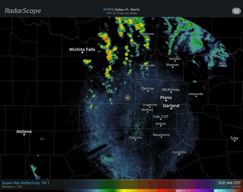 We could see more development later this morning, but I don't expect anything too severe. If a storm or two do turn severe this morning, they would most likely produce heavy rain and hail. Gusty winds may not be completely be out of the question. Today will be a very mild day in North Texas; temperatures are already in the low to mid 70s this morning, we expect to see a high in the upper 80s for most of the region. Some places might reach 90 degrees, especially for our areas to the west. FRIDAY THE 13TH NTX WEATHER SITUATION - After some crying and model data analysis, not much has changed since yesterday. A band of showers and potential storms will push to the east later this morning. Then, by the afternoon hours, redevelopment is possible for areas to the east of Dallas. These storms will develop and intensify as they move east towards East Texas where a more volatile atmosphere is in place. Severe storms are the most likely where the SPC has defined an "enhanced" risk and the standard "slight" risk for severe storms. 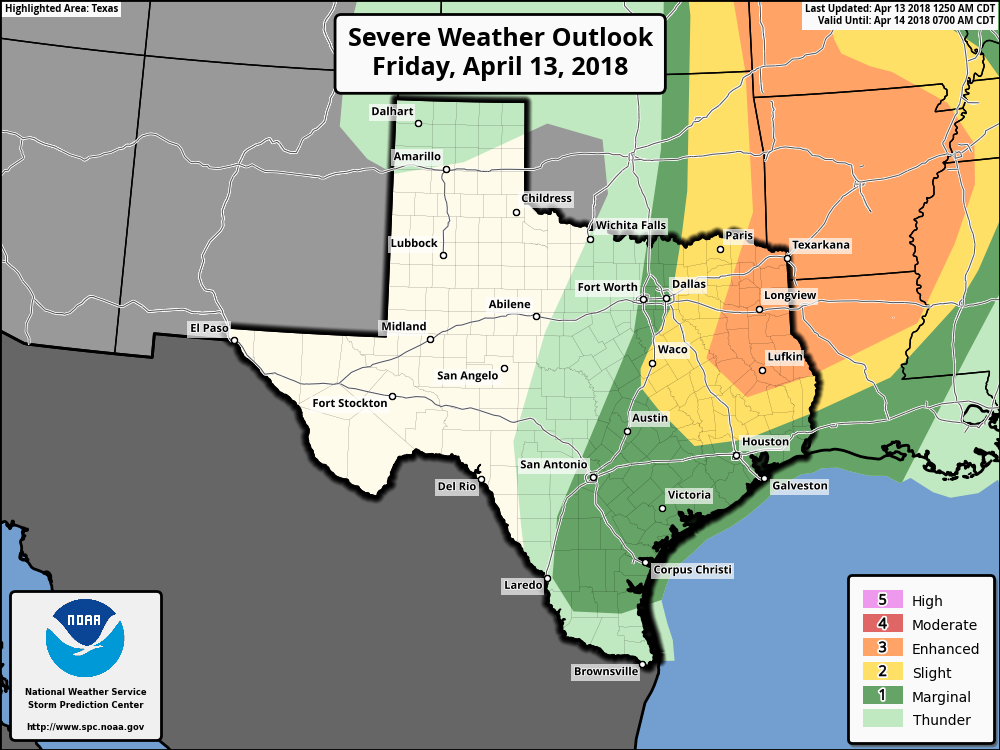 PLACEMENT - Most of the instability will be in east Texas, along and east of the dryline. However, a few severe storms is not out of the question for North Texas, though. THREATS - For those that see some severe in East Texas, the main issue may come from very large hail in some spots, but a few bouts of damaging winds and an isolated tornado or two is also possible. The tornado potential will be maximized in Louisiana and Arkansas, where they have the best combination of helicity and shear. Again, this is typical stuff that we see in April, nothing unusual. Just be prepared in case something does happen. THE WEEKEND - We will remain warm and windy through most of the weekend with sunny skies. Highs will be in the mid to upper 70s. NEXT WEEK - Most of next week for now looks mild and dry with highs in the upper 70s and low 80s. There is evidence that rain returns during the latter half of the week, which could help our Panhandle’s drought situation a little bit. See the Texas Weather Discussion Video for more details. 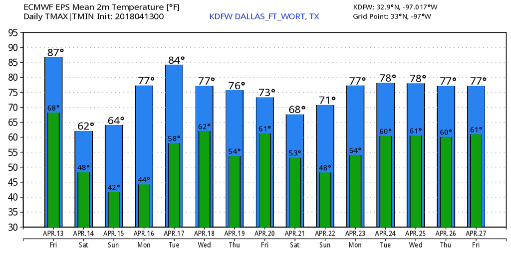 I will be down in Corpus Christi for four days starting tomorrow... Jonathan Williams should have the blog updates covered this weekend, and I’ll try my best to push blogs Monday and Tuesday!
*Texas Weather Discussion Video will come this afternoon, I promise ):* WARM MORNING - It is a warm morning across North Texas; DFW Airport reports 63 degrees; Graham and Possum Kingdom Lake are at 64. The day will be sunny with highs in the mid 80s. STRONG STORMS POSSIBLE FRIDAY - Confidence has been pretty good that rain and thunderstorms will impact the North Texas area tomorrow, but it has been difficult to resolve the details because of model discrepancies. The SPC has taken DFW out of any severe weather risk for Friday, while they maintain the 'marginal' risk for areas immediately to the east of Dallas. The standard 'slight' risk includes areas to the north of Houston and through Paris while the 'enhanced' risk of severe storms extends from Lufkin through western Kansas. 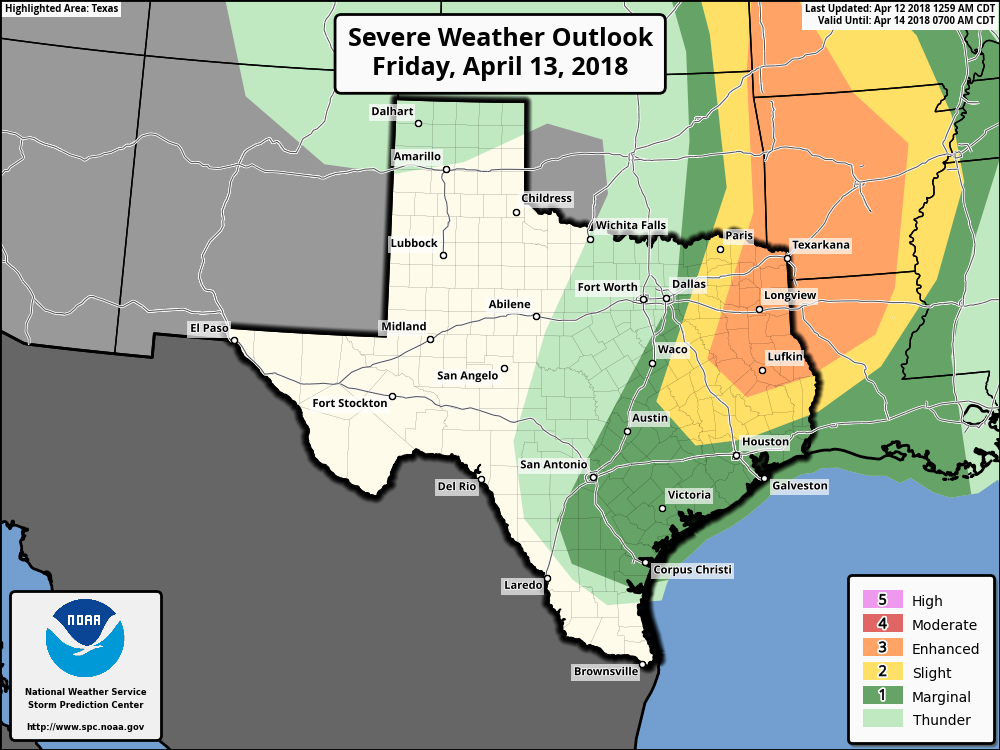 For the most populated part of North Texas, looks like we will see the potential for a few thunderstorms in some spots tomorrow morning, but organized severe thunderstorms do not appear to be an issue at this time. TIMING - Some scattered thunderstorms will start to affect North Texas during the morning commute, mostly in the form of rain and lightning. As we get closer towards the afternoon, storms will progress to the east, posing a threat for severe weather in the slight and enhanced risk areas. THREATS - Mainly in the slight and enhanced risk areas, given the high instability but sparse storm coverage, all modes of severe weather will be possible. Very large hail events appear likely, along with the risk for damaging winds and a few tornadoes, a couple of which could be strong in the enhanced risk area. That zone is being monitored for a potential upgrade to Moderate risk in later outlooks. Be sure to stay in touch with the blog for the latest details. THE WEEKEND - After the cold front comes through on Friday, cold air advection will follow the next day, and we fall back to the low 40s for lows during the weekend. Highs will be in the low to mid 60s with a sunny sky. NEXT WEEK - For now, most of next week looks dry and pleasant with afternoon highs in the upper 70s/low 80s. We will need to monitor the potential for more rain during the latter half of the week. 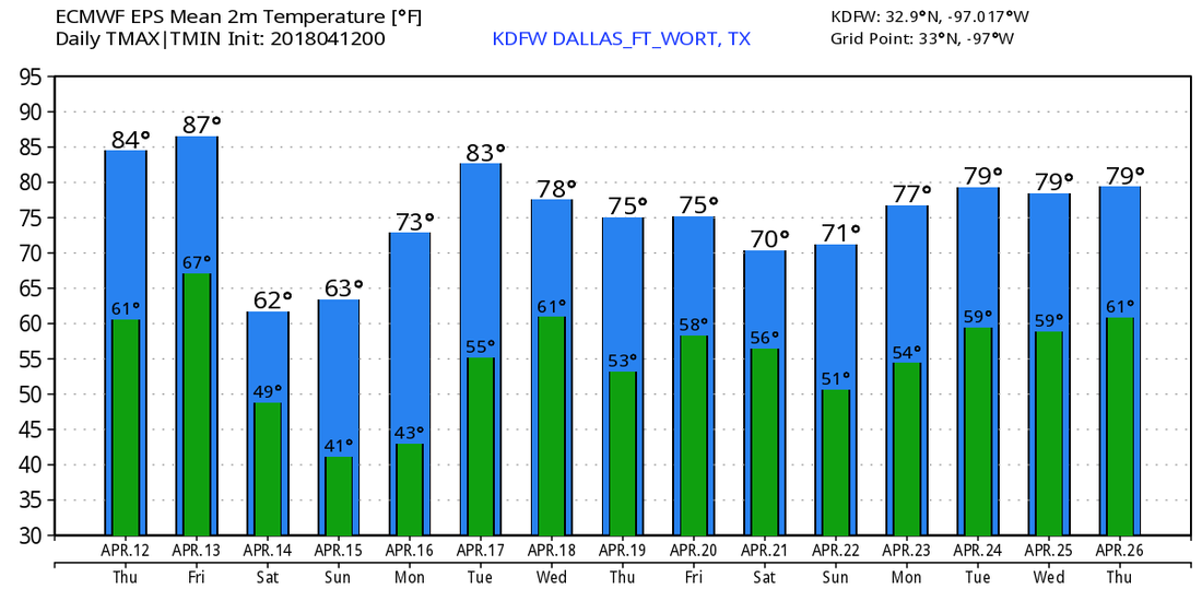 *No Texas Weather Discussion Video today* COOL START - Temperatures are currently in the upper 40s to the low to mid 50s across the region this morning. That's about 5 degrees below the average low for mid April. Today will be a very pleasant day but very mild with highs in the low 80s this afternoon. Winds may turn a little gusty this afternoon with a south wind of 20-30 mp/h. Tonight will feature mostly fair skies with overnight lows in the low 60s. We continue a warming trend through Friday, and Thursday should be mostly sunny with highs in the mid 80s this time. FRIDAY - This should be the warmest day of the warming series this week. We start the day in the upper 60s, ending up in the mid to upper 80s by the afternoon. A cold front and a dryline pushes east during the day, and we might see storm initiation along the dryline. You know what that means. Another severe weather risk is in place for Friday the 13th... 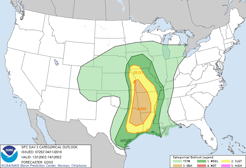 The Enhanced risk extends from Lufkin, Texas to the south of Kansas City. The standard "slight" risk of severe storms extends all the way from Houston to the east of Lincoln, Nebraska. The marginal risk clips areas along and east of the I-35 corridor. TIMING - A morning round of showers and storms is likely during the commute to work and school on Friday. Some of those storms could turn strong and produce at least some gusty winds. As they progressively move to the east, they will start to intensify over time in parts of extreme East Texas through parts of Missouri and Arkansas. As the cold front moves to the east during the afternoon, more development is possible. Once you start feeling cooler air and the front is to the east of you, the risk for thunderstorms for your area is over. THREATS - Storms will start out in a discrete mode at first, posing a risk for mainly large hail and a few tornadoes along the warm sector. The risk for damaging winds comes when the storms begin to transition to more of a linear mode. But keep in mind that most places in North Texas are under a marginal risk or no categorical risk of severe storms, so a few strong cells can pop out, but nothing too widespread. RAIN - Rain amounts will likely stay under 1/2 inch in most places, so flooding will not be an issue. THE WEEKEND - Looks like this weekend will turn cool and pleasant with sunshine in full force. High will only reach the low 60s due to cold air advection from the cold front. We start both days in the 40 degree range. NEXT WEEK - The early part of next week looks dry with cool night and pleasant days ahead featuring mostly sunny skies. Some rain can creep back in during the latter half of the week, but its too early for specifics.  PLEASANT DAY AHEAD - A good supply of sunshine is expected across North Texas today with a high in the lower 70s, which is about 5 or 6 degrees below the average high of 76 for April 10. Tonight will also be very cool and chilly for some spots; We will have a low mostly in the low 50s, though some of the naturally cooler spots could drop to the upper 40s. TOMORROW AND THURSDAY - We start a warming trend in advance of a storm system with warm days and fair, comfortable nights. Afternoon highs will be in the low 80s on Wednesday, and mid 80s by Thursday. Southerly winds will increase by Thursday in advance of a storm system, which could make the day quite breezy. STORMS RETURN FRIDAY - Showers and thunderstorms will develop along a dryline Friday afternoon and evening, and will advance to the east and northeast. Some of these storms could turn severe, with all modes of severe weather appearing possible. The area of greatest coverage will be in the in the severe weather risk the SPC has outlined for parts of North Texas extending into the lower Midwest. 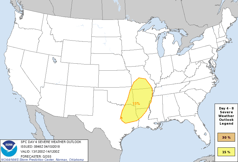 This risk does include areas strictly along and east of the I-35 corridor, but does not include Lewisville, Arlington, or Fort Worth yet. The bottom line is, whether you are in the risk or not, Friday looks to be a very stormy afternoon and evening for the region. We will be able to give more specifics once we get closer to Friday. The Weekend - After the cold front moves through, cold air advection will follow, which will make the weekend cool but very comfortable. Highs will be in the mid to upper 60s for both days. NEXT WEEK - The early part of next week looks dry with warm afternoons and cool nights. Highs will average in the upper 70s with lots of sunshine each day. See the Texas Weather Discussion Video for more details.  CHILLY START - Temperatures are in the mid 40s across North Texas this morning, that's about ten degrees below the average temperature for early April. Not as cold as this weekend, but definitely weather to warrant wearing a jacket for. Luckily, we won't stay cold all day, and temperatures will reach the low 70s during the afternoon. The average high for DFW on April 9th is 75 degrees. Tomorrow will be very similar to today; cool nights, pleasant days, highs in the low 70s, lows in the mid 40s with lots of sunshine during the day. WEDNESDAY THROUGH FRIDAY - We start a warming trend through Friday. We will still stay pleasant with afternoon highs in the low 80s by Wednesday. We turn very mild by Thursday with highs reaching the mid 80s, and mid to upper 80s by Friday. Storm chances also return by Friday afternoon with a cold front and a dryline for storms to initiate. Some could turn severe with the possibility of all hazards. The Storm Prediction Center has parts of East Texas and the lower Mississippi Valley under a risk of severe weather for day five (Friday). 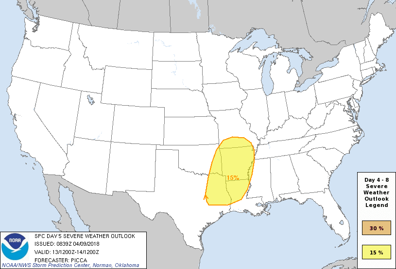 At this time, it is too early to specifically tell the placement of the dryline, and the possible hazard types. We will likely see the outlook chance within the coming days. THE WEEKEND - After the cold front moves through the area, cold air advection will follow, which means more cold air for the weekend. We won't see freezing temperatures like last weekend, but highs will struggle to get out of the 60s and 70s. Both days will feature a sunny sky with pleasant conditions. NEXT WEEK - The early part of next week looks pleasant and very dry. Most days will continue to feature sunny skies with afternoon highs in the low to mid 80s, just a little above average for mid April. See the Texas Weather Discussion Video for more details. 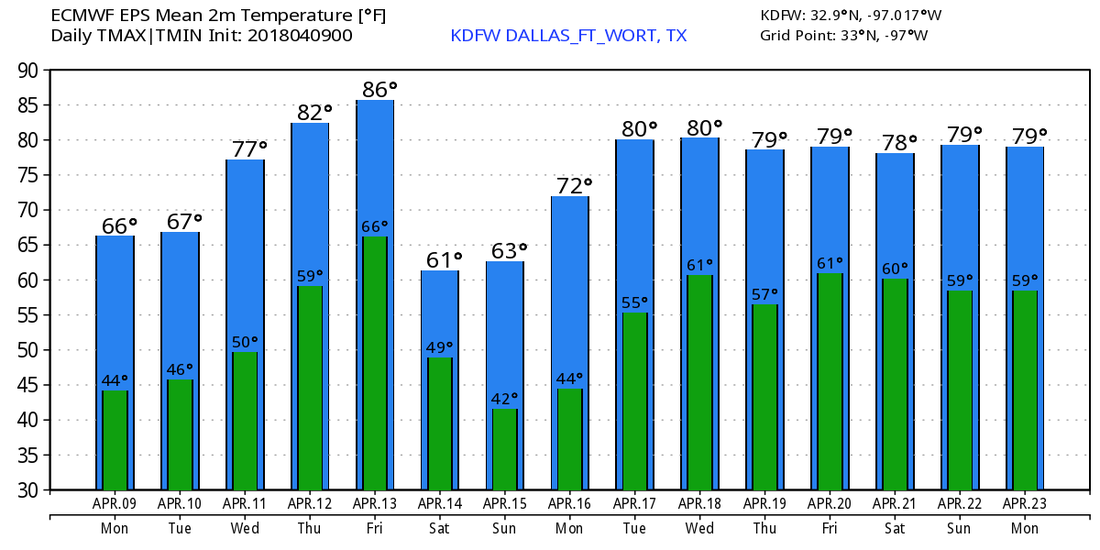 After a relatively chilly day, we will clear out overnight. We will fall to the mid 40s overnight, but our far northern counties may fall to the upper 30s.
We will warm up to the upper 60s tomorrow afternoon with partly cloudy skies in play. On Tuesday, we will warm up even more to the lower 70s. Abundant sunshine is expected to be in place. On Wednesday, we do the same thing all over again with highs in the upper 70s. Some moisture will return, likely with afternoon cumulus clouds with fairly humid conditions in place. On Thursday, we will do the same thing AGAIN, but highs will be in the mid 80s. On Friday, a cold front and a dryline will approach the area during the afternoon. The newest guidance has trended farther to the west with the dryline, increasing our storm chances. Most of the ensembles/models have surface based convective available potential energy approaching 3000 J/kg with higher amounts likely. The feature during the day Friday will be a deep/amplified mid-level trough that will approach the Plains during the afternoon hours on Friday. It will increase west/southwesterly flow aloft will bring in steep lapse rates over the southern plains. Also, strong low-level mass response will feature a corridor of enhanced theta-e transport, mainly from Texas to the lower Missouri Valley. As a dry line and cold front move into this area of interest, (including the Dallas/Fort Worth area) it will weaken the cap and allow for severe storms to develop along and east of this feature. At this time, this feature (dryline) remains the most uncertain at this time. I expect to get these details refined and more precise heading into the upcoming week. The most favored area for severe weather looks to be along and east of a line from Bowie to Mineral Wells to Hamilton. While it's too early to become too specific, steep low-level lapse rates will support a risk of very large hail, and the bulk shear from the surface to 500mb will support a risk of rotating supercells leading to a risk of tornadoes and damaging winds. Because of these severe weather parameters being in place, I think it's safe to say at this point that all modes of severe weather may be possible during this time. As the cold front will bring strong cold air advection into the region, highs will struggle to get out of the 50s & 60s heading into Saturday, but a warming trend looks to take place on Sunday into next week. Jonathan Williams Weather Forecaster/Meteorologist Severe Weather Specialist NWS/NOAA Ambassador After possibly one of the coldest days in April history, we warm up!
We are currently in the lower 50s, but are expected to warm to the upper 50s and 60s. We are expected to remain mainly cloudy through the rest of the day, but a few peeks of sunshine are possible late this afternoon. We will only fall to the mid 40s overnight, but our far northern counties may fall to the upper 30s with clearing skies overnight. We will warm up to the upper 60s tomorrow afternoon with partly cloudy skies in place. On Tuesday, we will warm up even more to the lower 70s. Abundant sunshine is expected to be in place. On Wednesday, we do the same thing all over again with highs in the upper 70s. Some moisture will return, likely with afternoon cumulus clouds with fairly humid conditions in place. On Thursday, we will do the same thing AGAIN, but highs will be in the mid 80s. By Friday, a dynamic storm system and dryline/cold front combination will cause for very warm temperatures and a chance of showers and thunderstorms in the region. A fairly large severe weather threat will be in place along and east of the dryline. Right now, where exactly the dryline sets up is still in question. We will closely monitor where it sets up, because it could be our second significant severe weather event. (Friday was our first significant severe event) At this time, I think the highest severe risk will be along nad east of a line from Bowie to Graham to Stephenville. We will cool off to the 60s next weekend with sunshine in place. Jonathan Williams Meteorologist Storm Specialist NOAA/NWS Ambassador After a very crazy afternoon, things will change. But first, let's talk about today.
As expected, numerous severe storms, some very intense, occurred in DFW today. We even had a tornado warning for the Plano area, and the McKinney/Allen area. The NWS will be surveying for damage. Very large hail also occurred today. Some areas had hail larger than baseball size. These storms were very intense making for a very scary day for some. And unfortunately, this is the first of many significant severe risks. We are in our prime tornado season now through June 1st. We will have plenty more days like today in the next 2 months, so be prepared. The strong cold front is now through the DFW area, and is pushing the severe storms southeast of our area. We have turned colder into the 50s/60s. We will fall into the mid 30s overnight. We will monitor a disturbance in Oklahoma that may bring a chance of light sleet or freezing rain to parts of the region tomorrow morning. If the DFW area falls a degree or two colder than expected, some light wintry precipitation is possible. The main area of winter weather will be north of DFW. While we dont expect a big storm, a few areas northwest of the metroplex may see light accumulations leading to a slick spot or two mainly on bridges and overpasses. I don't see any travel impacts for the DFW area. Its not completely ruled out to see a few flakes of snow or pellets of sleet tomorrow morning. Again, NO ACCUMULATIONS OR IMPACTS for the DFW area. We will likely see all light rain, but again if we fall a degree or two colder, I can't rule out a very light wintry mix. We will only warm to the lower 40s according to the NAM. I will have a forecast high of 44°F. We will fall to near freezing Sunday morning, but will quickly reach the upper 50s and 60s. We may have a brief chance of a shower early Monday morning. (Less than 20%) We will warm up and be mainly dry mid week. Storm chances return next Friday, and yet again, some of those may be severe. Looking towards mid/late April, we may turn very active and stormy, leading to more severe weather. Jonathan Williams Meteorologist Storm Specialist NWS/NOAA Ambassador RADAR CHECK - A couple of showers has formed in north Texas and parts of southern Oklahoma, as expected. We will see them move to the east at daybreak this morning. Today will be overall cloudy & warm this afternoon. Most places will reach the mid 80s this afternoon. We will maintain the risk for scattered showers during the afternoon, but severe storms will arrive this evening. The Storm Prediction Center maintains a "enhanced risk" of severe storms from Longview extending into Mississippi. The "slight" risk extends into the DFW metro, the I-35 corridor and points to the east.  While the CAPE values will be the highest its been all season, other factors come into play, such as the placement of the main convection, and other parameters that really determine the severe risk. By the afternoon hours, the cap will already have weakened, which will allow severe thunderstorms along the cold front to freely move through the region. The good news is, most of the severe parameters remain to the southeast of the metro (southeast Texas), but, we could see some severe storms that could pack a punch in a highly unstable airmass. TIMING - The window for strong to severe storms in North and central Texas will be from 6PM this evening to 12AM overnight. THREATS - The main issue with storms in the metroplex will be large hail. Some of the strongest storms could produce hail more than 2” in diameter. An isolated tornado or two can’t be ruled out with some weak shear in the region. The damaging wind threat will be maximized in east Texas extending to the Mississippi Valley. RAIN - Rain amounts will likely be in the 1/2 - 1” range for much of the region, not sufficient enough to cause flooding concerns. tl;dr - The overall severe weather risk remains very conditional for north Texas. We will keep our eyes on the radar this evening. The main threat is not in North Texas, but you always need to expect the unexpected when it comes to these risks. VERY COLD DAY TOMORROW - After the storms clear the area Friday night, cold air advection will follow, which will keep us cloudy and very cold for most of the day on Saturday. The NAM also has us in the mid 30s for most of the afternoon as well...  The same model also brings a chance of very light freezing rain for some places in the region. With freezing temperatures in some spots, we will likely see that happen for our northern counties. It will not feel like spring at all in the Deep South. In fact, these temperatures will be about 30 degrees below average for early April. It be a raw, cold day across the state. The sky will clear to sunny skies on Sunday with highs in the mid to upper 70s. NEXT WEEK - We could see some widely scattered showers and thunderstorms during the day on Monday, and next week looks overall dry with highs in the 70 degree range. See the Texas Weather Discussion Video for more details. 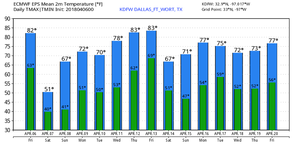 We have a strong system bringing a chance of severe weather heading into tomorrow. Let's talk about it!
First of all, I expect the morning hours to be mainly dry, but a few isolated showers or a storm isn't ruled out northeast of the metroplex, especially into SE Oklahoma. By the noon hour, we will be in the mid 70s. This is when things become more interesting. We will have abundant instability tomorrow, and we will monitor the risk of isolated supercellular storm development. The cap looks to erode, but models haven't really picked up on much storm development during the afternoon hours. I still think a storm or two may develop. Should they develop, any storm will likely turn severe quickly with very large hail and damaging winds. These storms will be more discrete in nature, so they will have the potential to rotate and produce a tornado IF they develop. Again, this is between 12PM through about 5PM. A strong cold front will be approaching the Red River by late afternoon. Temperatures ahead of the front will be in the mid 80s in the DFW area. In our western/northwestern counties, thunderstorms will develop by late afternoon. These storms are expected to push southeast and affect the DFW metroplex early to mid evening. The storms will have supercellular structures, so they will pose a severe risk. The risks are highly dependent on the overall coverage and linear potential. If the storms remain more separated from each other (a broken line) of supercell storms, they will produce very large hail and damaging winds, and possibly a tornado or two. The other possible outcome is that they congeal into a linear structure (squall line) and produce mainly a straight-line wind risk and a chance of an embedded tornado or two. If the storms are in the squall line, it will limit the overall large hail risk. But, it still will produce a hail risk of up to ping pong ball, but it won't be as significant as the broken supercellular line. There are plenty of factors in play that make this a tricky forecast. A few models (not all, and in fact not many) have the storms more post-frontal rather than pre-frontal, migitating the overall severe risk. Many other models have it more as a pre-frontal solution, increasing the overall severe risk. Another factor is does the DFW area see any supercells during the afternoon hours. If that happens, our atmosphere will be stabilized and will only allow for general (non-severe) thunderstorms along the cold front. Since the coverage of supercells during the afternoon hours will only be 20%, it's more likely that the line will be severe than the DFW area seeing a supercell during the afternoon. Another factor is very significant instability. We will have some of the highest values we have seen since last spring. The storms that develop (especially with the pre-frontal solution) along the cold front with significant instability will aid in a more significant severe event compared to the more isolated ones we've had earlier this spring. And another factor is the morning storms in Oklahoma. Do they send out an outflow boundary? An outflow boundary basically works like a mini cold front. It could kick off some intense supercells IF one penetrates south and if one even develops. This would occur more in the afternoon if we see an outflow boundary. Another factor is the cap. (CINH) How strong or how weak is it will greatly increase or decrease the overall risk of severe weather is still unknown. Most models have it eroding, but model or two keep it mainly in place. As you can tell, there are plenty of factors and uncertainties with tomorrow. We will be here tomorrow and will Update you throughout the day. The TEXAS WEATHER DISCUSSION VIDEO will be released by 7AM tomorrow. Have a blessed night, Jonathan Williams Meteorologist Storm Specialist NWS/NOAA Ambassador |
Archives
April 2024
Categories |
 RSS Feed