
|
RECORD COLD MORNING - For many communities outside of the metroplex, temperatures are a touch below freezing, leading to a rare mid-spring freeze across parts of the NTX region and much of the midwest. Here are some of the observed temperatures early this morning... DENTON 33 DFW AIRPORT 40 ARLINGTON 36 GAINSVILLE 32 SHERMAN 32 JACKSBORO 29 MINERAL WELLS 31 GREENWILLE 33 ROCKWALL 36 HILLSBORO 34 To put things in perspective, our average last freeze date is March 12, and our latest last freeze on record is April 13, 1957. We didn't break that record in the metroplex, but we did get really close. We did break our old record low of 39° in the metroplex this morning for April 21. The good news is that we should warm up very nicely this afternoon with a mostly sunny sky with high clouds increasing late in the day. Highs will maintain in the low to mid 60s, just like yesterday. Clouds will stick around for the day tomorrow with some sprinkles at times. Highs will stay in the mid 60s due to cloud cover. SEVERE WEATHER POSSIBLE FRIDAY - A dynamic weather system will bring the possibility of severe storms for much of the south-central Plains and much of the North-Central Texas region Friday afternoon and evening. The Storm Prediction Center continues a large standard "slight" (2/5) risk of severe storms for all of North and Central Texas throughout much of Central Oklahoma. 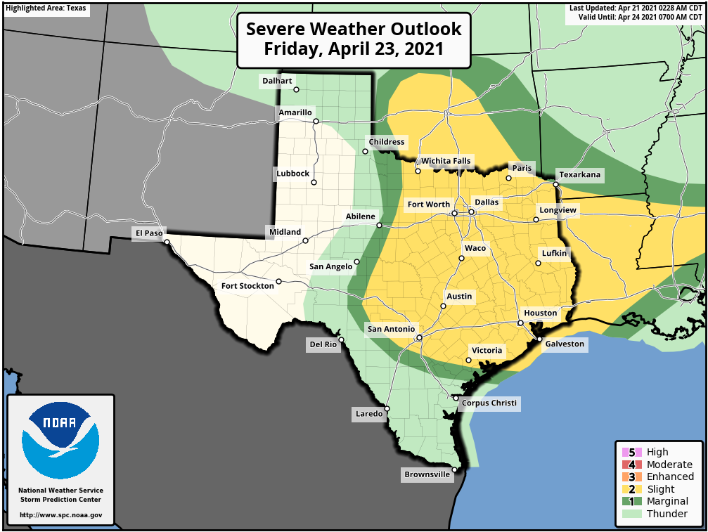 All modes of severe weather appear possible, including the threat for very large hail up to the size of baseballs, in addition to isolated tornadoes. Once we get within 60 hours of the event (that will be later this afternoon and evening) we will get within range of the convection allowing models, and will have a much better idea of the timing and magnitude of the threat. Just know that Friday will be a day where it is imperative that you are weather aware. Dry air returns Saturday morning, and the weekend should be quiet and dry with highs in the upper 70s on Saturday, followed by the low 80s on Friday. NEXT WEEK - Our weather will be very warm and dry on Tuesday... the high Monday will be in the low to mid 80s by the afternoon. A dynamic weather system will spark another chance of severe weather on Tuesday for North-Central Texas through Central Oklahoma. At this time, it appears that all modes of severe weather are possible once again. The SPC has introduced a standard "slight risk" zone for the aforementioned areas, but greater probabilities may be needed if trends continue. See the Texas Weather Discussion Video for more details. 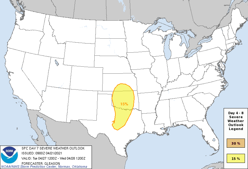 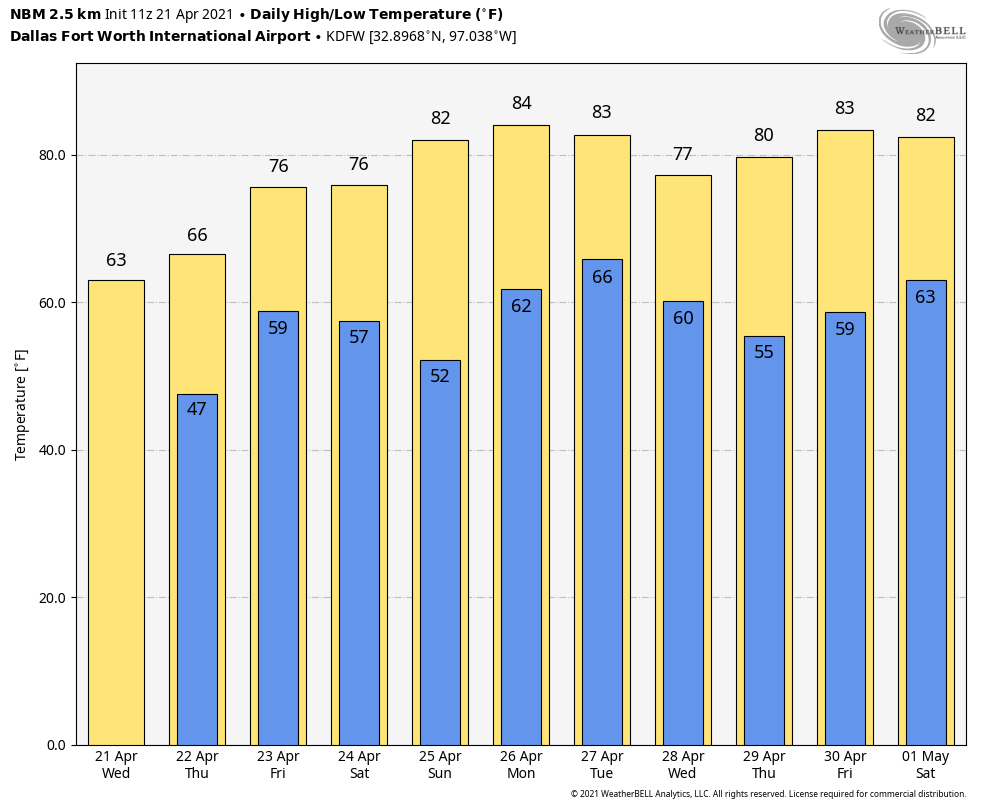 ON THIS DATE IN 1967 - Severe thunderstorms spawned 48 tornadoes in the Upper Midwest. Hardest hit was northern Illinois where sixteen tornadoes touched down during the afternoon and evening hours causing fifty million dollars damage. On that Friday afternoon, tornadoes struck Belvidere IL and the Chicago suburb of Oak Lawn, killing 58 persons.
RADAR CHECK - Another disturbance is currently bringing beneficial rain for a good chunk of the region this mid-morning.  You may hear a few claps of thunder with some of the heavier storms, but all of the storms this morning have remained below severe limits. The SPC is maintaining a low-end "marginal risk" (1/5) of severe thunderstorms for much of the region due to a chance of some of the stronger cells producing hail up to the size of quarters. 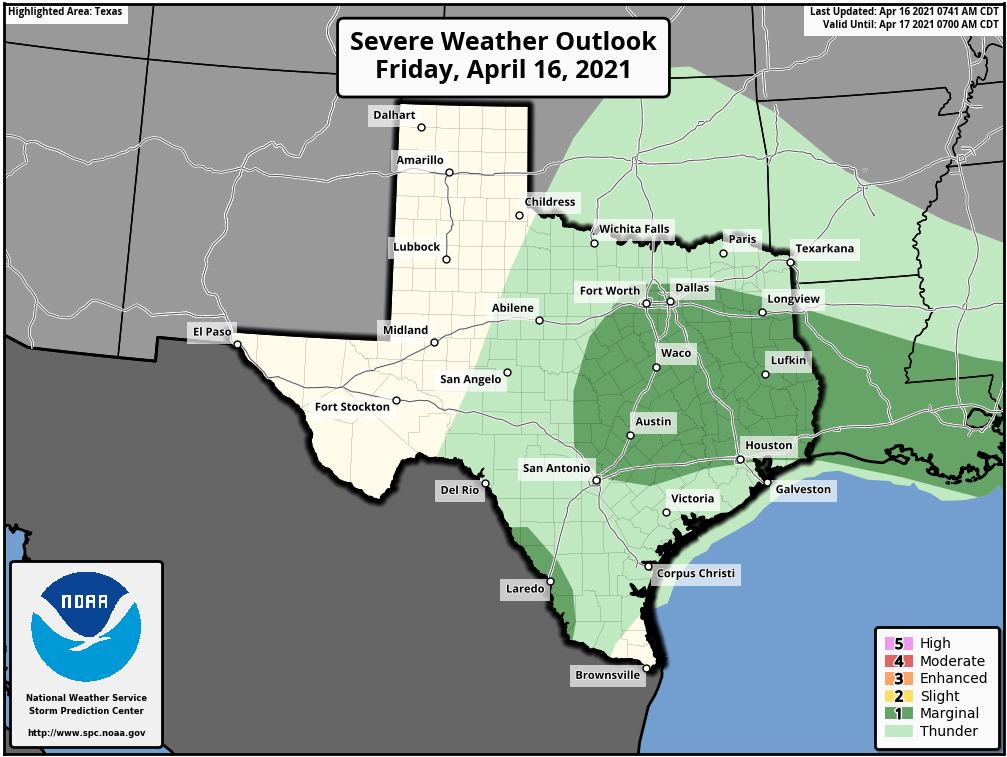 Expect some breaks in the rain by the late morning, and most of the rain should be out of the region by late afternoon with only a few leftovers. I expect a cloudy sky across the state today with temperatures remaining in the low to mid 60s this afternoon, that's about ten degrees below average from our normal high in mid April. THE WEEKEND - I expect a dry weekend ahead as dry air behind the cold front moves through the region. The sky will be mostly cloudy on Saturday (with some periodic breaks) with a chilly breezy northerly wind. Therefore, we are keeping afternoon highs in the low 60s across NTX. Then the sun will appear in sudden fashion with highs warming up to the mid 60s. NEXT WEEK - The weather looks quiet for much of the week. We will begin a gradual warming trend on Monday with highs starting out at around 70° by the afternoon. Monday and Wednesday will feature a sky filled with sunshine, followed by Tuesday and Thursday featuring a mix of sun and clouds. Temperatures will remain seasonably average next week. We will welcome our next chance of rain by Friday afternoon with a shortwave trough positioned near the Arizona/Mexico border. See the Texas Weather Discussion Video for more details. 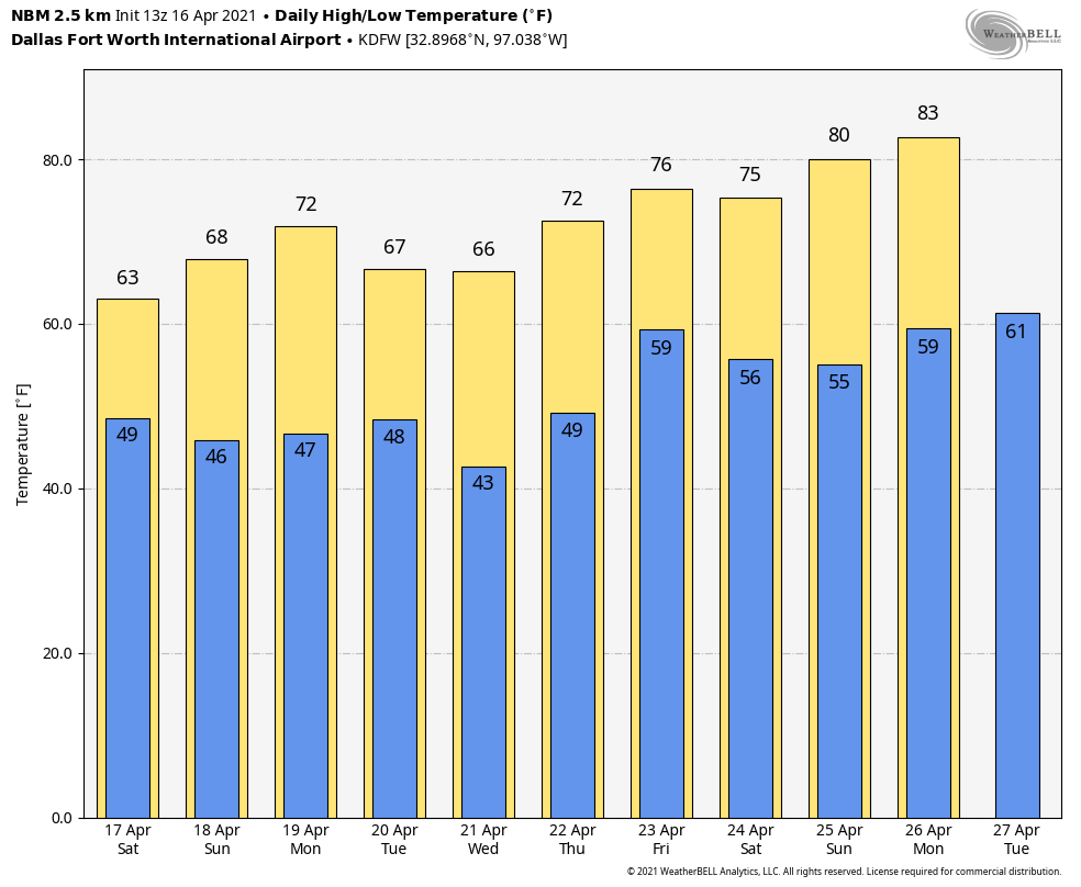 ON THIS DATE IN 2011 - The same system that produced 45 tornadoes in Alabama on April 15, 2011 moved eastward; North Carolina was the hardest hit state. Thirty confirmed tornadoes occurred in North Carolina, the greatest one-day total for North Carolina on record. A total of 24 individuals lost their lives in North Carolina with thirteen tornadoes classified as strong (EF-3 or higher).
RADAR CHECK - Rain continues to fall this afternoon over much of Northwest Texas into West-Central Oklahoma... the rest of the region is dry with a field of clouds. Temperatures are in the upper 70s where some breaks in the clouds have been observed; the northern counties are still in the 60s because of clouds. Scattered rain will increase over North Texas during the midnight hours, and there will be periods of rain through Friday as multiple disturbances past through the region. A few heavier storms with hail up to the size of quarters are likely tomorrow during the day over areas to the south and west of the metroplex, where the SPC has a low end, "marginal risk" (1/5) of severe storms. However, I do not foresee any severe weather issues for most of the region.  Expect mostly cloudy skies tomorrow through Friday evening with highs staying in the 60s for much of the metroplex. THE WEEKEND - Most communities will be mostly cloudy on Saturday, though lingering showers and thunderstorms during the afternoon is not out of the question. Then, a punch of dry air pushes into the region on Sunday, where we should see most communities enjoying a good supply of sunshine by the afternoon with highs in the mid 60s... about ten degrees below average for mid-April in North Texas. NEXT WEEK - A quiet weather pattern ensues. The weather looks dry Monday through Thursday... some rain could return toward the end of the week on Friday. Temperatures will be near, or, a little below average. See the Texas Weather Discussion Video for more details.  ON THIS DAY IN 1935 - Black Sunday refers to a particularly severe dust storm that occurred on April 14, 1935, as part of the Dust Bowl. During the afternoon, the residents of the Plains States were forced to take cover as a dust storm, or "black blizzard," blew through the region. The storm hit the Oklahoma Panhandle and Northwestern Oklahoma first and moved south for the remainder of the day. It hit Beaver around 4:00 p.m., Boise City around 5:15 p.m., and Amarillo, Texas, at 7:20 p.m. The conditions were the most severe in the Oklahoma and Texas panhandles, but the storm's effects were felt in other surrounding areas.
RADAR CHECK - Isolated thunderstorms are occurring over West Texas, just to the north of Abilene... The rest of the NTX region is dry with a partly sunny sky. Temperatures are in the low 80s to the southeast where the sun is out; DFW remains in the mid 70s due to clouds. Rain and thunderstorms will increase over Oklahoma this evening, and there will be a chance of showers overnight. A few heavier thunderstorms are likely outside of the metroplex, where the SPC continues a low end, "marginal risk" (level 1 of 5) of severe storms. However, there will not be any severe weather issues tonight for most of the region. 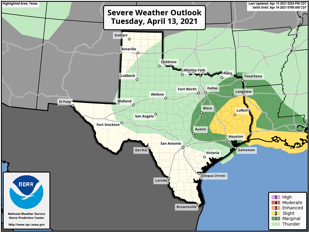 The best chance of rain over the eastern half of the state will come during the pre-dawn hours tomorrow. The day will be noticeably cooler tomorrow with highs in the upper 60s in the metroplex. THURSDAY THROUGH THE WEEKEND - Most of Thursday afternoon remains dry with highs in the upper 60s and a partly sunny sky. Then, multiple waves of isolated to scattered showers and thunderstorms are possible Thursday evening through Friday afternoon. As a result, we will forecast a mostly cloudy Friday sky with highs only reaching the mid 60s. We will mention another 1 in 5 chance of showers Saturday morning as another weak disturbance moves through. Most of the metroplex will be dry over the weekend... The sky will feature more clouds than sun on both days with highs between 60 and 65 degrees. NEXT WEEK - The weather remains quiet; generally dry with temperatures around seasonal averages. See the Texas Weather Discussion Video for more details.  ON THIS DAY IN 1987 - Wind gusts up to 98 mph in northern Texas were caused by thunderstorms. At the Killeen Airport, storms caused $1 million in damage. Two planes were destroyed and ten others damaged.
The Texas Weather Discussion Video is a detailed weather discussion that goes far beyond what is normally shown in a traditional TV setting! From Donovan Neal and ApexStorm - Dallas/Fort-Worth. ACTIVE WEATHER AHEAD - A dynamic storm system will bring multiple chances of severe weather from the southern Plains through much of the Deep South this afternoon, evening, and through parts of Saturday morning. The SPC has defined a moderate risk of severe storms (4/5) for the lower Mississippi River Valley, with an Enhanced Risk (3/5) surrounding it.  Closer to home, we have the standard "slight" risk (2/5) of severe weather for most of the metroplex, with the enhanced risk in the northeastern corner of the state for this afternoon and evening...  TIMING - Keep in mind that the threat for severe storms today remains very conditional. The cap, which is the warm layer just above the surface, is known for keeping North Texas safe from major severe weather events when they are forecast. If storms had the best chance to break the cap, they would do it from around the 3:00-9:00p hours. THREATS - Any storm that develops will remain isolated. That being said, most places will stay dry this evening. However, said storms would be capable of producing hailstones greater than two inches, and maybe an isolated tornado or two, especially to the east of US 75. RAIN - Rain amounts are expected to stay fairly light, with many locations getting nothing at all, while some places will receive downpours from the isolated storms Just make sure you have a way of getting warnings this afternoon and evening as very large hail will be a concern with any severe thunderstorm that develops in the metroplex during the PM hours. The sky becomes mostly sunny tomorrow as a dry slot moves into the state... the high will be in the mid 70s. SUNDAY AND NEXT WEEK - Sunday and Monday will feature a mix of sun and clouds with dry weather on both days. Highs will stay pretty close to the low 80s with fair nights. A few showers and storms are likely Tuesday through Thursday, with severe weather possible on Friday. See the Texas Weather Discussion Video for maps, graphics, and more details. 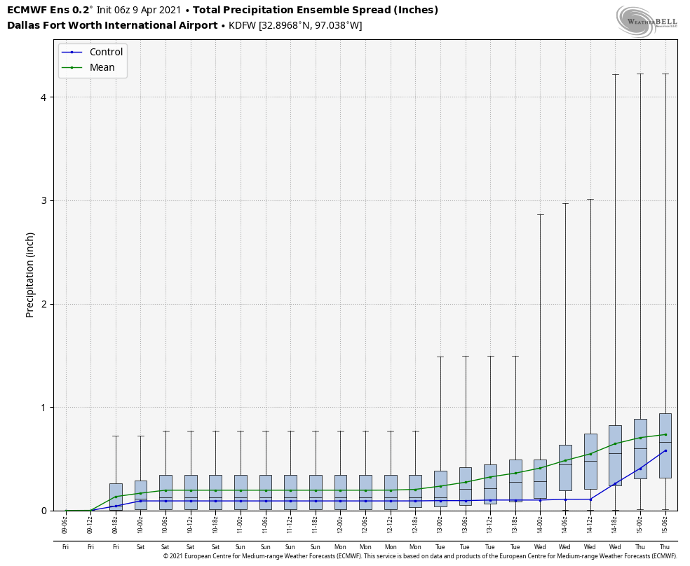 ON THIS DATE IN 1947 - An estimated F5 tornado struck Woodward, Oklahoma during the late evening killing 95 persons and causing six million dollars damage. The tornado, one to two miles in width, and traveling at a speed of 50 mph, killed a total of 167 persons along its 221-mile path from Texas into Kansas, injured 980 others, and caused nearly ten million dollars damage.
CONNECT - You can find me on most of the major social networks.... ApexStorm Weather Text Messaging System Be sure to join the text message remind and follow my twitter for weather updates throughout the day... enjoy the weekend! |
Archives
April 2024
Categories |
 RSS Feed