
|
FOGGY MORNING: Temperatures are in the 50s across the board in the North Texas region. With a combination of moist, warm air, places are experiencing dense fog this morning, and a Dense Fog Advisory remains in effect for all of North and Central Texas this morning. The sky will feature mostly cloudy skies, but the day will be mostly dry with only isolated showers about. A cold front will arrive this evening, which will set off showers, which will arrive this evening and persist into early Thursday morning. The best chance of rain will come during the early morning hours tomorrow, and highs will stay in the low 50s. Then, on Friday, clouds should eventually dwindle down as we become mostly sunny with a few clouds in place... we currently project a high in the low 70s. THE WEEKEND: The overall forecast confidence in this weekend's forecast remains relatively low with a very sophisticated pattern across the South. Saturday will turn mostly cloudy and windy with a cold front coming through during the early morning hours. We will only reach the mid 50s by the afternoon with showers possible at times. The greatest threat of anything will come Sunday morning through the afternoon with the cold airmass in place. There is significant spread in the global model output, as the Global Forecast System (GFS) shows nothing but a cold rain with falling temperatures, while the European model (ECMWF) shows a cold rain after a brief period of light snow/mix. We will again trend towards the Euro's scenario and adjust the forecast to a colder, more precipitation prone day. Rain amounts over the weekend will be very light and will stay under a quarter of an inch for most communities. NEXT WEEK: Very cold arctic air will stay in place across the region. Highs will be in the 40s for the early part of next week with lows well into the 20s. Colder pocket around the DFW Metroplex could see upper teens by Wednesday morning. Temperatures moderate by the latter half of the week. See the Texas Weather Discussion Video for more details. 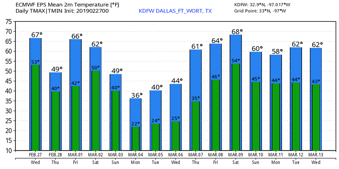 VERY PLEASANT AFTERNOON: Despite mostly cloudy skies, temperatures are mostly in the 60 degree range across North-Central Texas this late afternoon. We do note the severe thunderstorm warning polygon in Cherokee counties in East Texas. Clouds will continue to hang out overnight.  TOMORROW THROUGH FRIDAY - Although a cold front will come through early morning Thursday, the weather shouldn't change too much over the next few days; we expect mostly cloudy skies with showers still very few and far between. The high will warm to the low 70s as the streak of mild temperatures continues. Our best chances of scattered showers come Wednesday evening overnight through early Thursday morning. Then, chances dwindle down Thursday afternoon. The sun will come out Friday, but we will still be partly cloudy with highs in the low 70s. THE WEEKEND: Global models are currently split on the potential on a weekend forecast solution, so there is still lots of uncertainty. The one thing we are very certain about is the cold front surging through late Friday evening through early Saturday morning. This will bring another fresh batch of clouds to the region with colder temperatures. Highs will be in the mid 40s on Saturday. Sunday is where models begin to crash. Some are more aggressive in terms of winter weather, and others only indicate light rain or even dry conditions. To keep things really simple with these blogs (as we always try to do), we simply don't know what's going to happen yet. However, if we see any ice, sleet, or snow, there is a high chance the precipitation would stick, given the arctic front coming through. To see the best of both worlds, we will stick with scattered showers with some chance of a wintery mix during afternoon/evening. Once again, this is five days out, and a lot of things can and will change. Highs will only reach the low 40s, but we could be colder... NEXT WEEK: We have been trending towards dry conditions as we start the week. However, there is a great possibility that we will stay below freezing on Monday, then we warm slowly through the rest of the week, eventually ending up in the low 50s by Friday. Cold air stays in place for next week with temperatures below average for early March. See the Texas Weather Discussion Video for more details. 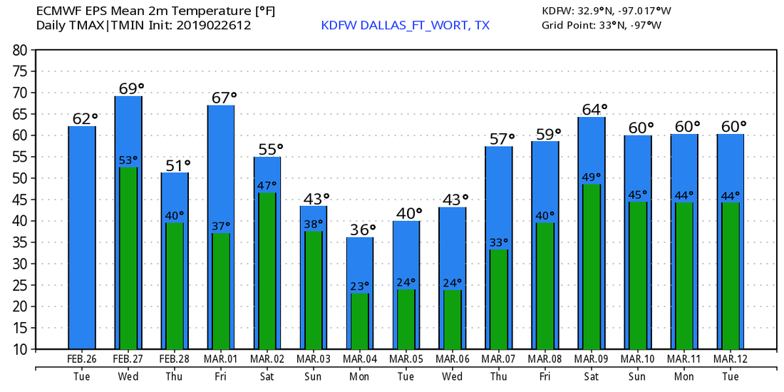 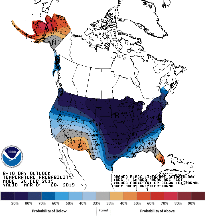 Good afternoon all, Jonathan Williams here... As you likely have heard by now, there is a threat of winter weather as we move into the late part of the weekend. However, there is extreme uncertainty regarding if this even happens, amounts, impacts, and how widespread it would be. IF winter weather occurred, it will likely be able to stick and cause problems with a very cold airmass in place if there was enough precipitation. And that is a significant IF. And the models are split regarding how much precipitation there is. The ECMWF is more aggressive and shows widespread precipitation. Meanwhile, the GFS keeps it more isolated. Here is a detailed explanation from the NWS Office in Fort Worth, TX... NWS - Things start to get interesting (and perplexing) on Sunday. Another shortwave trough will move out of the Rocky Mountains, but this time, at a lower latitude than the one on Saturday. This shortwave trough will act to amplify a longwave trough that will be in place over much of the CONUS. The result at the surface will be a deep intrusion of arctic air across the interior CONUS, including here in North/Central Texas. This synoptic pattern is shown by both the GFS and ECMWF, but with significant timing differences. The ECMWF is faster, and perhaps a bit stronger than the GFS. The ECMWF also shows more widespread precipitation developing within the cold air, whereas the GFS is on the drier side. A closer look at the GFS however shows that parcels are near saturation with condensation pressure deficits generally less than 25 hPa. This means that it would not take much more synoptic-scale ascent than is being advertised by the GFS to result in the development of precipitation (it is no surprise that the ECMWF shows larger height falls, and has the more widespread precipitation). Given the "qualitative" assessment of the synoptic environment, we are inclined to lean a little bit towards the ECMWF. Some of the features within the synoptic setup include the aforementioned height falls, large PV anomalies around the 500 mb level, a 120+ knot jet streak, and conditionally unstable lapse rates. All of this is to say that there should be lift, and there should be cold air. The only question is will we have enough parcel saturation to get precipitation processes started. As you can tell, there is a lot of questions we will have to get answered before we can truly have a good handle on this situation. Similar to the NWS, we will lean towards the ECWMF solution. However, we are keeping winter weather chances on the low side until we have a better handle on this situation. Here is a look at our 10 Day Forecast... 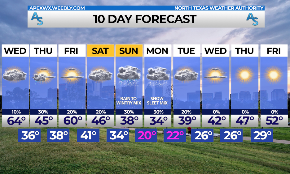 For now, we urge you to stay up to date on the forecast, as IF some of our models verify, we could see some impacts from this system.
Rain, freezing rain, sleet, and snow all seem like plausible scenarios, creating a difficult forecast for us. Stay tuned... Jonathan Williams Main Graphic Creator for ApexStorm NWS Weather Ready Nation Ambassador COOL START - Temperatures are currently in the upper 40s to low 50s across the great region of Texas this morning; the air remains mostly dry and we expect thick clouds to hold in place with a high in the low 60s this afternoon; very similar to yesterday, just without the sun. Any showers that develop will trend more to the east and should stay "few and far between" today. Clouds will hold in place overnight, with overnight lows only reaching the low 50s. WEDNESDAY THROUGH FRIDAY: The weather should be relatively dry (for the most part) for the rest of the workweek. We turn sharply mild on Wednesday with highs in the low 70s during the afternoon with mostly cloudy skies. A cold front moves through overnight, and we could see morning lows well into the 30s an 40s. In fact, places to the northwest of the metroplex could see some light freezing rain during the early morning hours if they can get below freezing. That's a big IF, and not everyone will see freezing rain. For those that do, I don't expect any accumulations or impacts. The day Thursday will be mostly cloudy again with highs in the low 60s. Then we turn partly cloudy on Friday with afternoon highs in the low to mid 70s with morning lows in the mid 40s. THE WEEKEND - This will be another one of those cold weekends where we will seriously have to watch the *potential* for winter weather of some sort on Sunday. An arctic front blasts through the region Friday overnight, which will put us below freezing for lows for most of the weekend. We only reach the mid 40s on both days. Global models have been indicating the potential for winter weather of some form. Most recently, it has latched onto the idea of some ice/freezing rain for parts of North Texas, but don't get too caught up with precipitation types. The exact precip. types and/or impacts are currently unknown at this time, as it is too early to establish an accurate forecast for this event. We will continue to mention a cold, cloudy day on Sunday with rain possible at times. NEXT WEEK: We stay dry for much of next week, but we will retain very hilly temperatures with lows below freezing for much of the week. The sun start to show during the latter half of the week. Temperatures overall look to be way below average for all of the week. 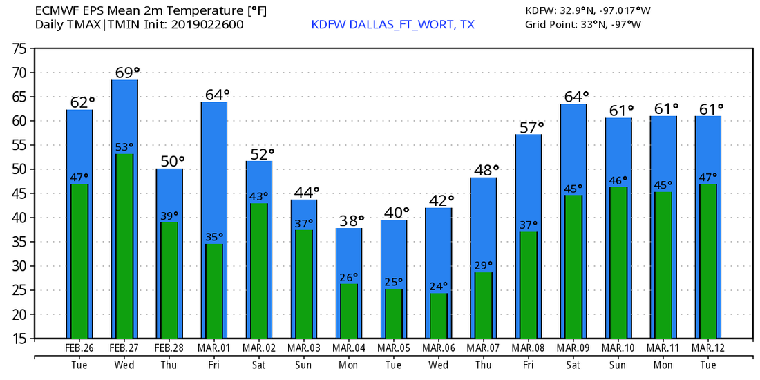 *no Texas Weather Discussion Video this morning* COMFORTABLE DAY AHEAD - Temperatures this morning are in the upper 30s/lower 40s across North Texas... Sunshine will be in full force afternoon, so expect highs in the lower 60s later, which is where we should be for late February. Moisture increases tomorrow, and there could be showers at times during the day as moisture increases again. We turn mostly cloudy on Tuesday, but highs will still hold in the mid 60s with overnight lows in the low 50s which is actually above our average low of 42° for February 25th. MID-WEEK - Not much change. Clouds still hold on Wednesday with the potential for a couple of showers throughout the day, but we turn sharply warm with highs reaching the low 70s by the afternoon A cold front comes through overnight between Wednesday and Thursday, which will result in scattered showers during the morning hours before drying out (maybe becoming sunny) during as the afternoon begins. Highs will only reach the low 60s on Thursday. We kick off the first day of Meteorological Spring (the first day of March) with a mix of sun and clouds with mild, breezy conditions. Afternoon highs will reach the mid 70s once again with a southwest wind of 10-20 mph. Overnight lows will stay in the mid 40s. THE WEEKEND - Another cold front comes through Friday evening which has the potential to keep us in the upper 20s to lower 40 degree range for a while. We expect partly cloudy conditions on Saturday with afternoon highs in the low 40s. There is a good chance that we continue to stay dry on Sunday with afternoon highs in the low 30s with a mix of sun and clouds. The lack of moisture across North Texas precludes the risk of wintery weather for the weekend, so expect a cold, dry two days for now. NEXT WEEK - Monday will be mostly dry with highs in the low 40s, then lots of questions arise Tuesday. Lots of talk regarding the potential for some type of wintery weather has been surfacing over this past weekend. Still way too early, but if anything were to happen, accumulations would remain light for now. Regardless, temperatures look to be below average for at least the early part of this week. 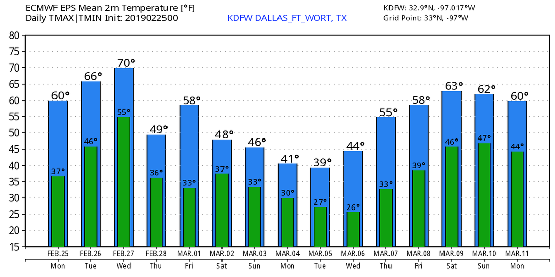 TORNADO SURVEY: The tornado that hit Columbus, Mississippi directly was a strong EF3, according to the National Weather Service in Jackson. One person was killed there, and 11 injuries were reported. This is the first intense tornado of the year. It has been 667 days since a violent (EF4+) tornado has touched down in the U.S.
RADAR CHECK - A few showers were moving Northeast generally forming a line. This will probably persist throughout the day with showers at at times throughout the afternoon and evening. No flooding or severe weather issues are expected. We will maintain mostly cloudy skies with afternoon highs in the mid 50s. Some areas of fog is possible this morning. THE WEEKEND - A line of showers and thunderstorms is possible early Saturday morning before the warm front passes through. Rain should persist until the afternoon, where it should dry. We will warm nicely with mostly sunny skies and afternoon highs in the low 70s. The sun will be in full force Sunday with highs in the low 60s. NEXT WEEK - Much of next week will be dry with a mix of sun and clouds. Highs will be seasonably average for late February, and no significant cold snaps is expected for the next two weeks... See the Texas Weather Discussion Video for more details. 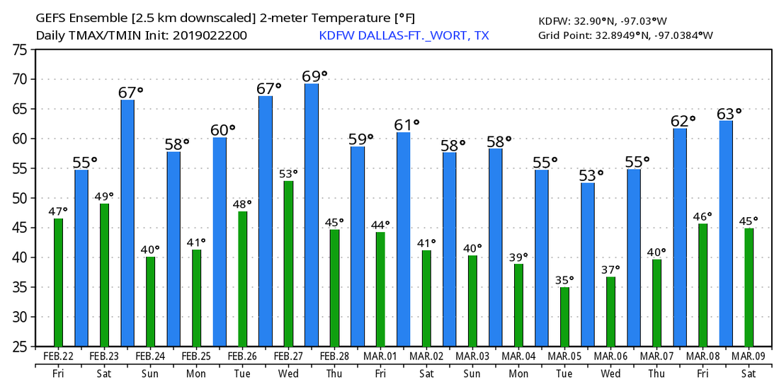 CLOUDY WEATHER RETURNS - Today will be yet another cloudy day for North Texas, but at least the temperatures will be significantly warmer than the last times as a warm front moves to the north of us again. A few showers will be possible throughout the day, and afternoon highs will be in the mid 50s. Showers and storms will develop over North and Central Texas Friday afternoon and continue through Saturday morning. Rain could be heavy at times with a few strong storms possible. The SPC has defined a "marginal risk" (1/5 risk) of severe thunderstorms for parts of North Texas, generally along and to the east of I-35. 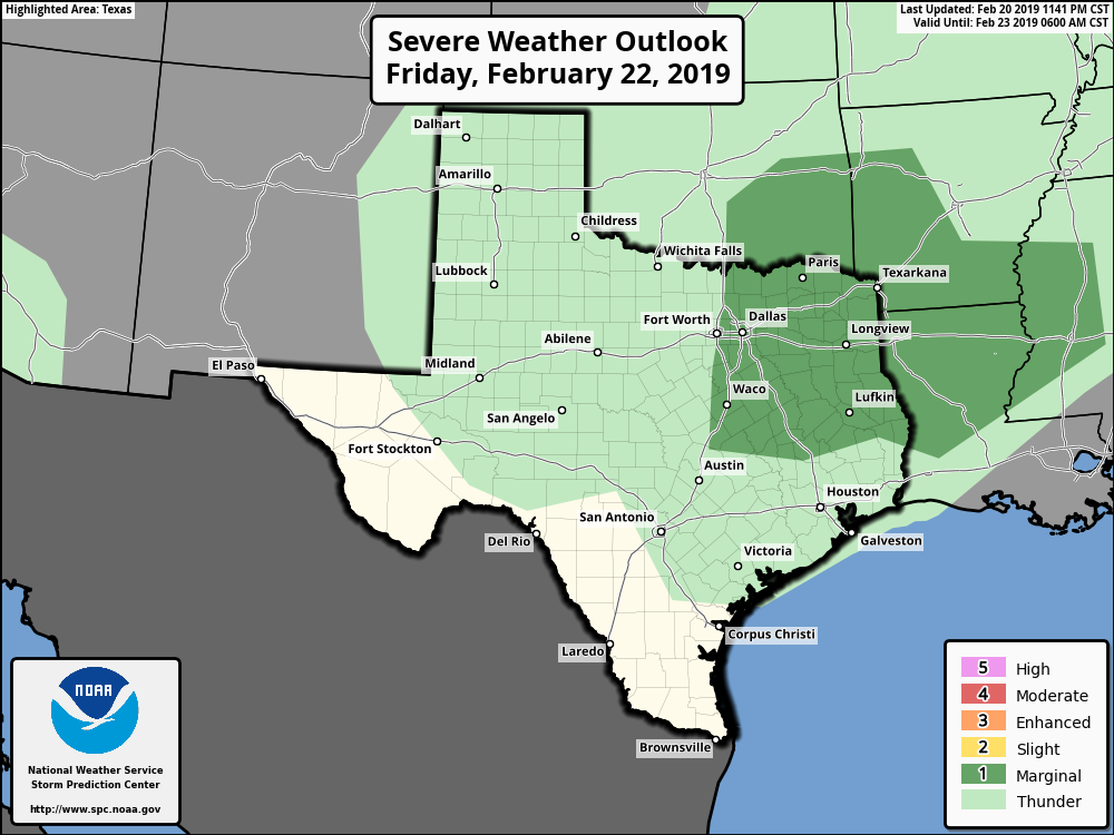 Some of the storms in the risk area could produce some hail and gusty winds at times. Might even watch for a very low-end chance of a brief tornado; we will remain vigilant and watch the radar throughout the evening. The high tomorrow will be in the upper 50s; a few degrees warmer than today. THE WEEKEND - Rain clears the area Saturday afternoon, and we will mention partly cloudy, breezy conditions for the rest of the day with afternoon highs in the mid to upper 60s. That storm system will lift to the northeast, posing a risk of severe storms for parts of the Mississippi River Valley. The SPC has defined an "Enhanced Risk" (level 3/5) of severe storms for parts of this area. 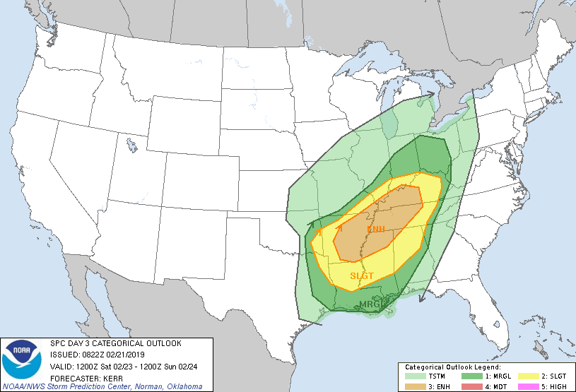 The main timeframe for severe thunderstorm development will come from about 3:00-12:00 midnight. The main threat will come from damaging winds and a few tornadoes from the discrete supercells, some of which could be strong. A high pressure builds over the state on Sunday... We will call it mostly sunny with highs in the low 60s. NEXT WEEK - Next week is shaping up to be a very pleasant week with highs mostly hovering in the 50s... See the Texas Weather Discussion Video for more details. 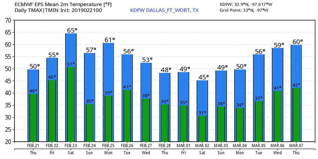 CHILLY AND DRY: As this day begins we have temperatures mostly in the upper 30s across North Texas in a cold airmass. In wake of a warm front, today will feature a mix of sun and clouds with highs in the upper 50s this afternoon. Another warm front will move to the north tomorrow, which will pull some moisture along with it. As a result, we will introduce mostly cloudy skies tomorrow with highs in the mid 50s. I wouldn't be totally surprised if we squeeze out a few showers from the moisture. FRIDAY AND THE WEEKEND - The warm front moving through the region by Friday will cause another chance of scattered showers and thunderstorms from the afternoon during the overnight hours on Saturday. There will be at least some instability in place, which is why the SPC has defined a "marginal" risk of severe storms for areas along and east of interstate 35. 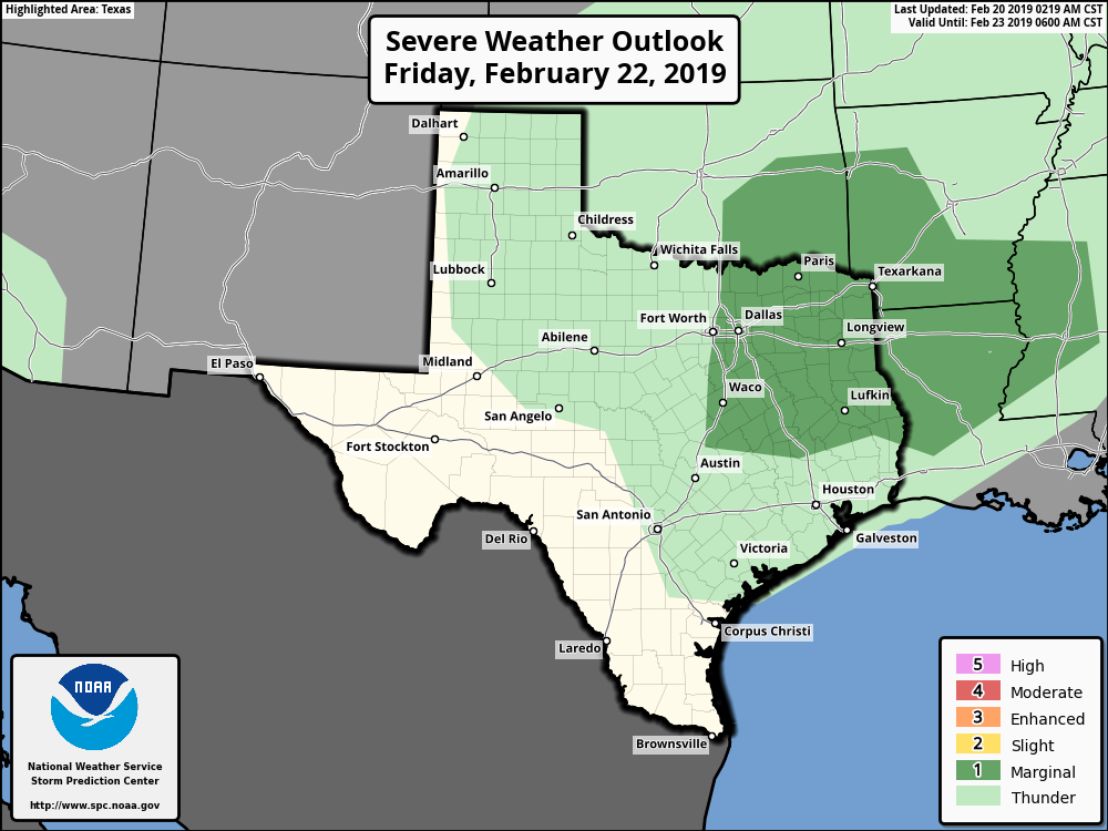 Only a few strong to severe storms are possible out of the mix, which may pose a risk for isolated hail and damaging wind gusts, nothing to bad. That storm system, along with the risk of severe weather, will shift to the east Saturday afternoon. We will remain mostly dry on Sunday with sunshine in full force with afternoon highs in the mid 60s. NEXT WEEK - Much of next week will be dry, but some showers could return on Saturday. Thankfully, it looks like that should be the only wet day of the week. See the Texas Weather Discussion Video for more details. 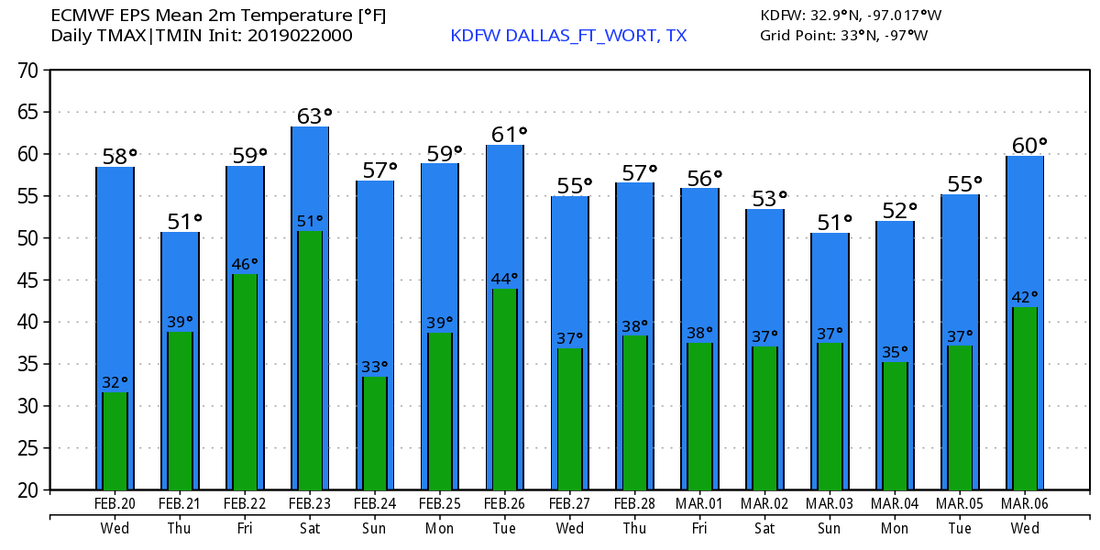 ANOTHER COLD, RAW MORNING - Temperatures are currently in the upper 30s closer to the metroplex with low to mid 30s to the north and northwest. We won't warm much today as we will probably hover around the same temperature category with the rain-cooled air in place. As advertised, the front will creep northward later today, and rain will become widespread across the region during the late morning hours. It will be a very cold rain for North Texas with temperatures sitting in the 30s for most. Some places along the Red River may fall below 32°, and that's when the chance of mainly freezing rain comes into play. At this point, I don't anticipate any freezing rain concerns for DFW, as we will be just a few degrees too warm, like always. We will see some clearing Wednesday with some sun coming out, and we will be much warmer with afternoon highs in the upper 50s. We quickly turn back to mostly cloudy skies on Thursday with highs still hovering in the 50s. Then the warm front moves to the north again and brings back scattered showers and thunderstorms to the state again beginning Friday. At this point, I am not anticipating a complete washout, and afternoon highs will be in the upper 50s. THE WEEKEND - Rain will continue into Saturday with some thunderstorms mixed in. Despite the risk of severe weather defined for the lower Mississippi River Valley, no severe weather for North Texas is expected. Just some beneficial rains with some thunder at times. 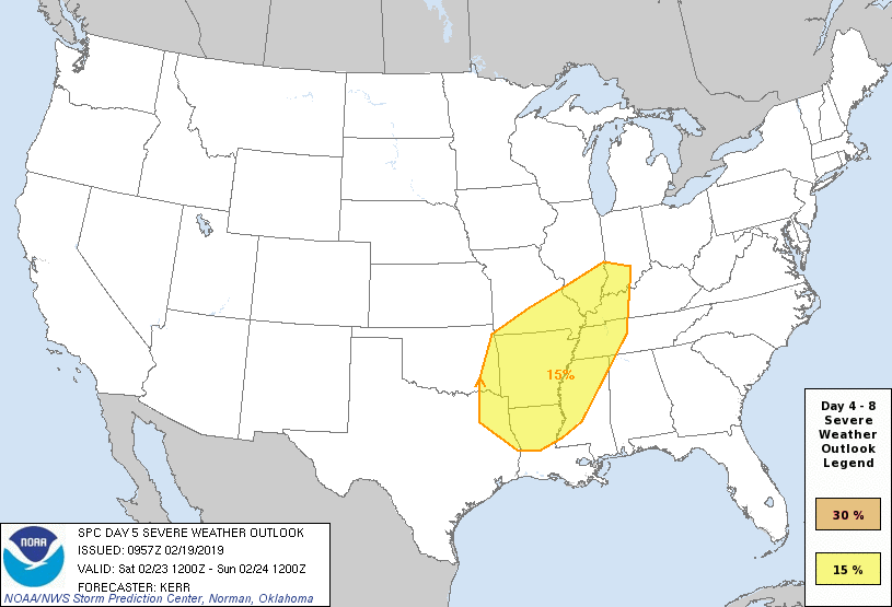 We turn surprisingly pleasant Sunday with sunshine in full force. Afternoon highs will be in the low 60s.
NEXT WEEK - For now, a good chunk of next week looks dry with seasonal temperatures. See the Texas Weather Discussion Video for more details. RADAR CHECK - Showers continue to move to the north from the metroplex. This should be something we should be accustomed to allday; cloudy with showers at times. A Dense Fog Advisory is in effect for most counties across North Texas. Visibilities are down to one quarter of a mile to even less at times. We will remain mostly cloudy throughout the afternoon with highs in the lower 60s. TUESDAY THROUGH THURSDAY - Expect a gradual warm up in temperatures up to Thursday. We turn mostly sunny Tuesday and Wednesday, followed by a few clouds by Thursday. Highs will be in the upper 50s tomorrow, followed by the mid 60s on Wednesday. We will reach the mid 70s by Thursday. FRIDAY AND THE WEEKEND - A cold front comes through early Friday morning, which will cause a wind shift from the northeast to the southwest, which will make for a very windy day. We turn sunnier by the afternoon with highs only in the mid 50s, which is actually a couple degrees below our average for mid February. Winds die down by the weekend, and Saturday will stay mostly sunny with highs in the mid 50s. Another cold front moves through during the overnight hours, and temperatures will be in the upper 40s by Sunday with a mix of sun and clouds. NEXT WEEK - Overall colder week. Showers at times will be possible at times during select afternoon. Mostly a mix of sun and clouds for the week. See the Texas Weather Discussion Video for more details. 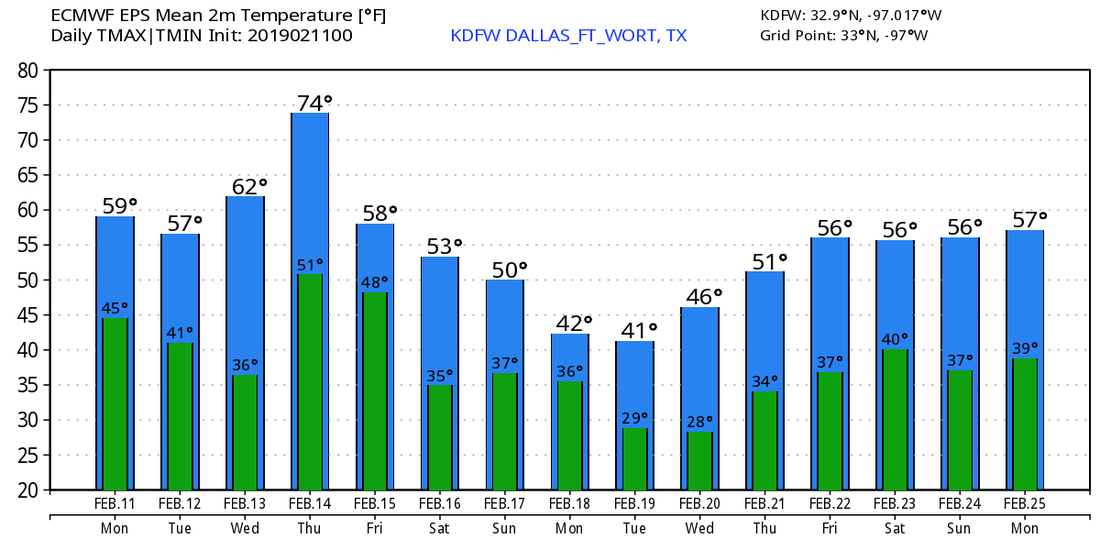 BITTERLY COLD MORNING - With temperatures in the low to mid 20° range, this is the coldest morning of the season for North-Central Texas. And we won't recover much during the day. We will only warm to the around 40° by the afternoon, with temperatures quickly falling by the evening. Some sleet/snow is possible for our extreme southern counties this morning. Some rain at times is possible during the early evening hours, with a very light wintery mix moving from the south. For North Texas, confidence is moderately high concerning the potential for sleet and/or a light wintery mix early this evening. Some of the mesoscale models shows accumulations of up to 1-2 inches for some spots in DFW. Let me stress that we do NOT expect any major accumulations, maybe 1/2" or a tad greater at best. I expect only a coating for most that get a mix. Additionally, some travel impacts will be likely, as this will most likely some through during the rush hour time period, which means traffic conditions will quickly deteriorate. Keep in mind that not everyone will see winter weather this afternoon, in fact, the best chance of a spot seeing sleet/snow this late afternoon/evening is basically 50/50. THE WEEKEND - Moisture may continue to advect from the north during the afternoon hours on Saturday, which would lead to rain at times during the afternoon. It will be very similar to today with afternoon highs in the low 40s with mostly cloudy skies. Some of the mesoscale models hint the another chance of freezing rain Saturday evening. We will mention a small chance of freezing rain, but nothing like this evening. We turn even wetter Sunday with afternoon highs in the mid 40s. NEXT WEEK - We begin to slowly moderate as we progress towards the latter half of the week. We will keep next week with partly cloudy skies with afternoon highs reaching towards the mid 60s by Friday. See the Texas Weather Discussion Video for more details.  RADAR CHECK - The line of heavy showers and thunderstorms is currently exiting North Texas, mainly moving more to the northeast. There are currently no severe weather warnings in effect for the state. Only a few reports of pea-quarter sized hail were observed this morning, but the roads on wet, so allow a few more minutes for the commute. The cold front has basically moved through north Texas at this point, so temperatures are already starting to go the wrong way. DFW recorded a temperature of 69° as of 4:42, but that has already fallen to 63° at the time I am writing this update. Sun will return later today, but we will already be well into the low 40s by the time it comes out. We fall even more, eventually ending up in the mid 20s by tomorrow morning. FRIDAY AND THE WEEKEND - We turn mostly cloudy and dry with another surge of cold air. Highs will mostly be in the low 40s by the afternoon hours. With some leftover moisture in the south, I wouldn't be too surprised if we see a few sleet pellets for areas to the south of DFW. Also, with a brisk 12 northeast wind, it will feel more like the upper 20s with any wind gusts we experience. Saturday will be very similar in nature; mostly cloudy and cold with highs in the low 40s. We warm a few degrees on Sunday, but moisture starts to increase again, and we will mention rain at times throughout the afternoon and evening. Afternoon highs will be in the low 50s. NEXT WEEK - Rain will continue to linger through Monday, before eventually tapering off in the evening. Expect a very slow increase in temperatures next week with mostly a mix of sun and clouds. See the Texas Weather Discussion Video for more details.  RADAR CHECK - Light to moderate rain is moving northeast through our northeastern counties. The heaviest of the rain will move towards the Red River vicinity later this morning. If you missed having some rain this morning, don't worry, we will have another chance of rain this afternoon and evening with potential for a few strong to severe storms. Temperatures are currently in the upper 60s/lower 70s this morning. We expect highs to be in the upper 70s later today with more or less of a sun and clouds mix. A FEW SEVERE STORMS POSSIBLE THIS EVENING - In advance of another strong cold front, severe storms will be possible from around San Angelo through the Ohio Valley. A marginal risk (level 1/5) of severe storms runs through that area above. The standard "slight" risk (level 2/5) of severe storms runs through the DFW Metroplex northwards towards the lower Ohio Valley. 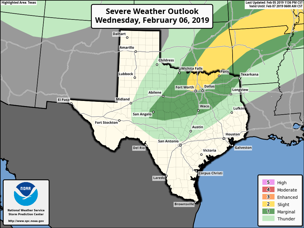 THREATS - More specifically, all modes of severe weather will be possible, including the potential for large hail, and a few tornadoes at times during the afternoon and evening hours. Thunderstorms will be more discrete in nature, so the tornado and hail risk will be a little bit higher in this scenario. However, we are NOT expecting an outbreak of severe thunderstorms. TIMING - Most of the severe storms will develop between 5-10PM over parts of North Texas, gradually tapering off overnight. Don't be alarmed if you experience rain during the day. This is just like any other risk of severe thunderstorms. No need to be alarmed or panicked about this. As long as you have a good safety plan in place and a reliable way to receive warnings quickly, there is nothing to worry about. THURSDAY THROUGH THE WEEKEND - After the cold front moves through, temperatures go the wrong way Thursday, with temperatures falling through the mid 40s by the evening hours. We turn sharply cold Friday morning with overnight lows in the mid 20s, and we only end up in the mid 40s with a mix of sun and clouds by the afternoon. We stay dry with afternoon highs in the mid 50s on Saturday, followed by another chance of showers and thunderstorms on Sunday once again, but we do warm to the low 50s. THE WEEKEND - At this point, much of next week (with the exception of Monday) looks partly cloudy and dry with highs mostly around seasonal averages. See the Texas Weather Discussion Video for more details. 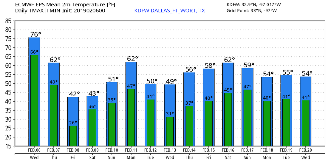 VERY MILD MORNING - Temperatures are currently in the 60° range across North Texas this morning, which surpasses our average low of 37° for early February. With a mostly sunny sky, temperatures will soar into the low 80s later today, which is above our average high of 58° for February 4. Tomorrow will be very similar to today; we will be down only a few degrees, and we will see more cloud cover. Tomorrow's low will be in the 60s; pretty similar to this morning. WEDNESDAY THROUGH FRIDAY - In advance of a cold front, showers and thunderstorms will become possible Wednesday afternoon through Thursday morning for North Texas. With anonymously high temperatures for early February, concerns for a few strong/severe storms are increasing, hence why the SPC has included some of the North Texas region in a "marginal" risk (level 1 of 5) of severe storms Wednesday afternoon and evening. 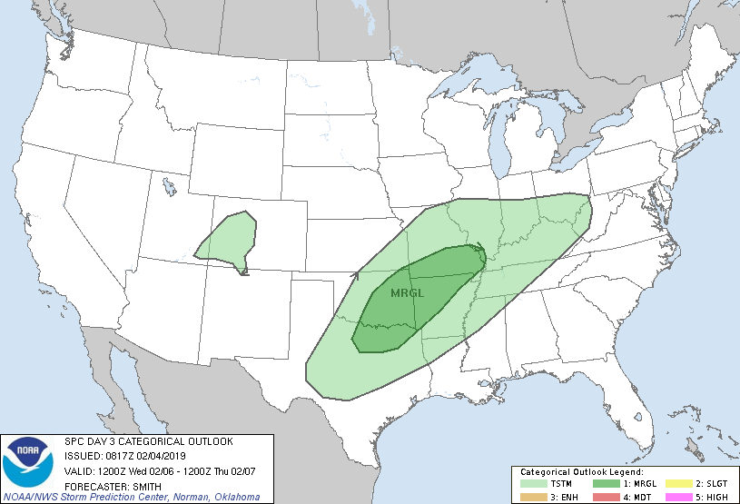 Other severe storms will be possible across the south-central US into parts of the Mississippi River Valley, but some of the strongest storms will be capable of producing some hail at times, and maybe one or two storms could have a couple of rotating updrafts by the evening hours. We are still more than sixty hours away from this severe storm threat, so continue to stay tuned for the latest details. For those that aren't in the severe weather risk, expect thunderstorms and rain at times Wednesday evening through Thursday morning. Amounts of only 1" - 1.5" is expected across North Texas, so I don't expect many flooding issues. Once the rain clears Thursday, temperatures will go the wrong way once we hit a certain point in the morning. We will peak mid-morning with temperatures in the mid 60s, then we will fall to the mid to low 40s by the evening hours with more clouds than sun. We start to catch a break from the rain on Friday, which should be a day featuring a mix of sun and clouds with highs in the mid 40s. Overnight lows may reach the upper 20s. THE WEEKEND - The first half of the weekend will be very chilly with cold air still locked in. We remain mostly cloudy for the weekend with highs in the mid 40s on Saturday. We warm to seasonal averages on Sunday, but may experience a few lingering showers. Highs will be in the mid 50s. NEXT WEEK - Some moisture may continue to linger Monday morning, but then we clear to mostly sunny skies for at least the early part of next week with highs in the 50s. At this time, we do not expect any significant winter weather issues for at least the next ten days.... See the Texas Weather Discussion Video for more details.  SOME FOG THIS MORNING - With temperatures in the mid 50s across much of the North Texas region this morning, and with some moisture in place, some places are experiencing some drizzle at times with fog in some communities. We will stay cloudy for most of the day with afternoon highs reaching the mid 60s for the first time in a while. A few showers at times are possible during the afternoon and evening. THE WEEKEND - We will remain cloudy on Saturday with afternoon highs in the mid 60s with showers at times possible during the afternoon. Once the moisture starts to move back to the east Sunday morning, we might be able to see some sunshine by the afternoon with highs in the low 70s by that point. NEXT WEEK - Monday and Tuesday looks mostly sunny and dry with highs in the mid 70s. A cold front moves through the region overnight on Wednesday morning, bringing in colder air and showers at times on Wednesday. We will fall into the mid 50s on Wednesday, and we will fall even more into the mid 40s by Thursday of next week with mostly cloudy skies. Friday and the weekend looks dry with temperatures staying in the upper 40s. See the Texas Weather Discussion Video for more details. 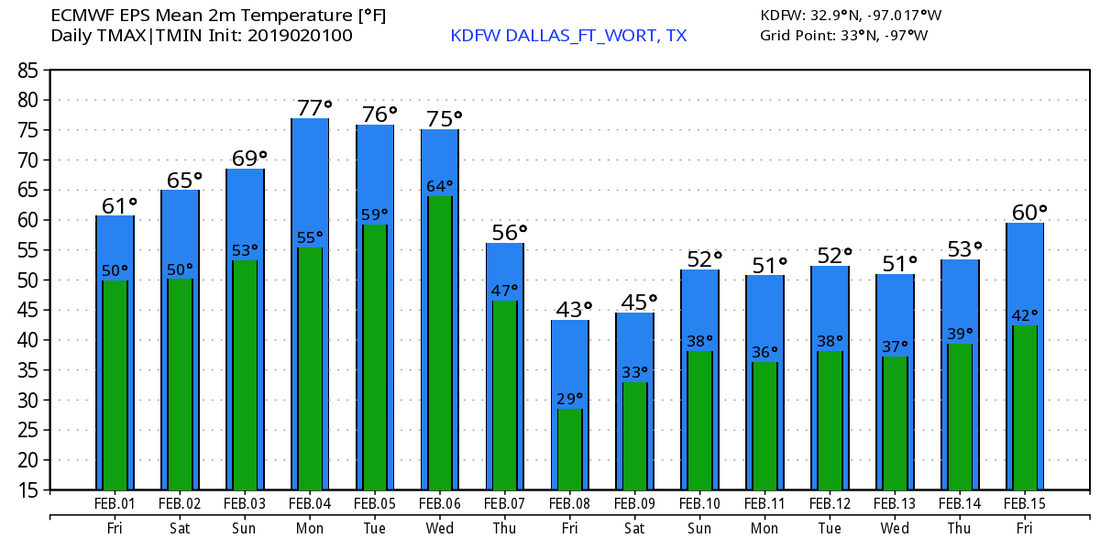 |
Archives
April 2024
Categories |
 RSS Feed