
|
Lunar Eclipse - The lunar eclipse is out in full force this morning across North Texas...  Be sure to go out and look during totality, which is expected to begin at around 6:51, peaking at 7:22, and ending at 10:08 AM. Besides, it is the perfect weather for some early morning photography this morning. We are currently in the mid 40s this morning, with warmer temperatures to the south. Today's high will be in the mid 70s, with increasing fire weather concerns due to mild temperatures, low relative humidity, and gusty winds. Most of North Texas is under an elevated to critical fire weather threat today, and conditions will improve tomorrow. Tomorrow will be a little cooler with highs in the mid 60s. Friday and the Weekend - A cold front arrives on Friday, which will put afternoon highs in the low 50s. The rest of the weekend looks dry as we start the day in the upper 30s with afternoon highs in the mid 50s. No signs of any wintery precipitation at this present time. Next Week - Early February looks dry once again with highs mostly in the upper 50s, seasonal averages for February. See the Texas Weather Discussion Video for more details. 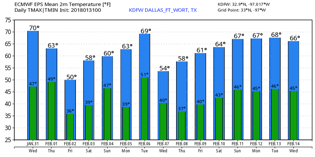 Light Freeze - Temperatures are in the upper 20s to mid 30s across the region this morning, and we will continue to stay in dry and mild conditions today. We project a high of 64 degrees, which is above the average January 30 high of 57 degrees. Due to abnormally low relative humidity values and gusty winds, fire weather concerns will return today and tomorrow for all of the DFW metro. The Rest of the Week Ahead - Tomorrow will be very windy and mild with highs in the mid 70s with a very sunny sky. We only stay that warm for a day, where we should fall back to the low 60s the next day. The next coldest morning of the week will come Friday, where we start the day in the low 30s, then we warm to the low 50s. A cold front comes through during the morning hours, which will bring a reinforcing shot of cold air during the day. The Weekend - Saturday will be a great day to do something outside. We start the day in the upper 30s, but we warm to the upper 50s with a good supply of sunshine. We trend cooler on Sunday, with signs of potential "wintery mischief" developing. The GFS has been exhibiting these signs over the past few days, but has not been consistent with the idea. Meanwhile, the reliable European global model continues to show a dry forecast. For now, we will stick with a dry forecast until we start to see consistency. The high Sunday will be in the mid 50s. Next Week - A cold front arrives on Monday, which will put us in the upper 40s for highs on Monday. But, we warm to seasonal averages for the rest of the week. The coldest arctic air will remain north of the state, with no signs of any terribly cold weather anytime soon. See the Texas Weather Discussion Video for more details. 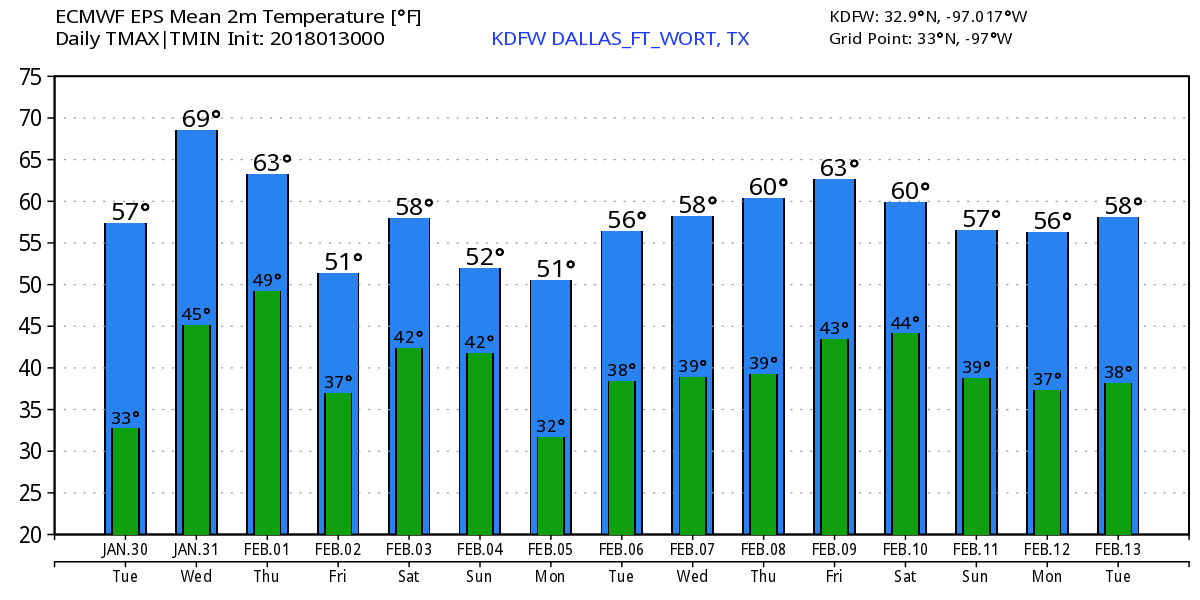 Chilly Start - We start the day in the upper 30s to low 40s across the region this morning with a cold front pushing down from the north bringing a reinforcement of cold air. It will be a cool day with highs in the mid 50s today. The average high in DFW for January 29 is 57. We turn even warmer tomorrow as we start the day in the mid 30s (light patches of frost?), then we warm to the low 60s. Another pleasant, sunny day. Some fire weather concerns may arise for the region as dry air mixes with wind and low humidity values. Wednesday through Friday - Not much change. Wednesday will be another mild day with a chance of us hitting the low 70s for the last day of January. And like magic, another cold front pushes down from the north Thursday morning, and we should still be mild but a bit cooler with highs in the low 60s. Then we cool down on Friday with highs in the low 50s, a few degrees below average for early February. The Weekend - With a mix of sun and clouds, the weekend looks mostly dry with highs ranging from the mid 50s to low 60s. Next Week - Another cold front is due by Monday morning, which will make the early part of next week cool with highs in the 50s. Right now, no signs of any winter mischief, but we will have to keep our eyes peeled for any new signals. See the Texas Weather Discussion Video for more details. 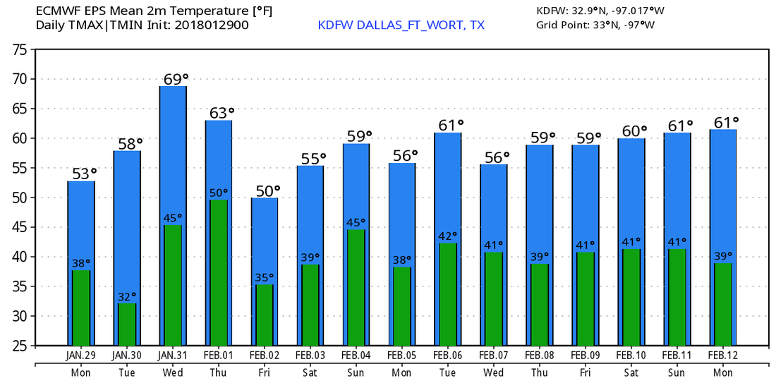 Cold Start - Temperatures are mostly in the mid to upper 30s this morning, but we should warm pleasantly to the mid 60s with abundant sunshine. Tomorrow will be a similar day, except expect clouds for much of the day. The Weekend - Saturday morning will be cloudy with a chance for a few showers as a cold front comes in from the northwest. It won't rain all day, but highs should still stick to the mid 60s with sunshine after the front passes. Rain amounts will stay below 0.3 inches over North Texas. Sunday will be a bright day with highs in the low 60s. No severe weather is expected, and any thunder will stay very minimal. Next Week - Look for pleasant days and cool nights during the early part of next week with highs in the mid 60s and lows in the upper 30s. Then, we trend colder for the first day of February, and highs should fall to the 40-50s. However, very cold air arrives February 4, carrying the risk of some ice pellets or freezing rain during the afternoon. No way of telling the specifics, but it should not be a significant event. The rest of that week looks cool and dry for now. See the Texas Weather Discussion Video for more details.  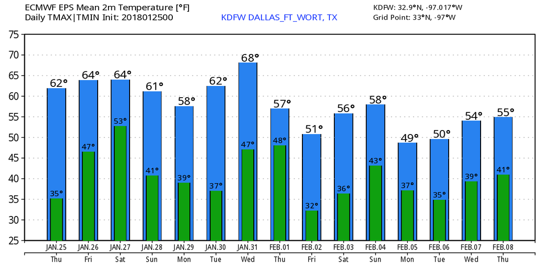 Cold Start - Cold, dry air continues to feed in this morning with temperatures in the mid 20s in some spots. A light freeze may have developed in some places with the cooler spots. The sky will be very sunny with afternoon highs in the low 60s. The average high for DFW on January 24 is 56. Tomorrow looks very dry and comfortable as well; We start the day in the mid 40s and we end in the mid 60s with a sunny sky. Friday and the Weekend - A corridor of moisture returns to North Texas on Friday, and that means we should introduce a chance of a few scattered showers throughout the afternoon with moisture surging in from the Gulf. We will also continue with a chance of a few showers and storms on Saturday with a cold front coming from the northwest. Timing is very uncertain, but the European global model shows a few showers possible starting Friday afternoon before it all exists the region by Saturday before midnight. Rain amounts are expected to be very light, and no severe weather is expected. Highs for both days will be in the mid 60s. It should dry out by Sunday, where highs will be in the low 60s with a sunny sky. Next Week - The last week of January looks dry with mild temperatures above seasonal averages with no sign of any arctic air for the rest of this month. 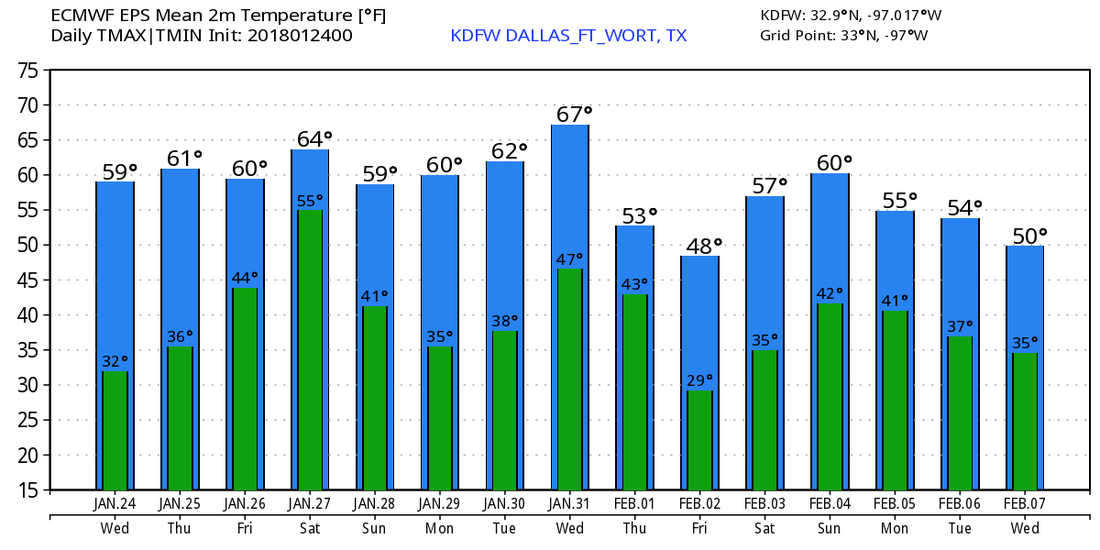 However, the European ensemble models continue to show that arctic air could make another debut to the U.S. as we get into mid February. No way to forecast this, but just continuing to monitor model trends and patterns... See the Texas Weather Discussion Video for more details. 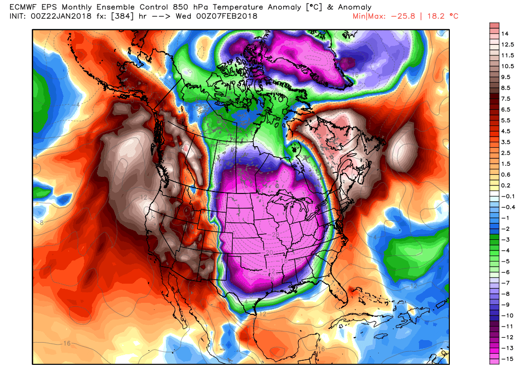 Freeze?? - Temperatures are in the 25-40 degree range across North Texas. A light frost may have developed in some places, but should quickly melt as the sun comes out. Today will be another pleasant day with highs in the low 60s, but not as windy as yesterday. The fire danger conditions have improved overnight. Rest of the Week - Luckily, we finally see consistent weather for North Texas. Dry, comfortable weather will continue Wednesday through Friday with highs in the mid 60s and lows in the mid 40s. The Weekend - Moisture will start to creep in during the day on Friday, and Saturday could be a mix of sun and clouds with a few showers at times. The GFS models continue to show very limited moisture surging in Saturday, and we will continue to mention the chance of a few showers during the day. Highs should be in the low 60s Saturday and mid 50s Sunday. The lows will be in the mid 30s to low 30s with a light freeze possible Monday night. Next Week - For now, much of next week looks very dry with highs in the upper 50s and lows in the low 40s. Cold Air?? - The European Ensemble model continues to suggest that very cold arctic air is still possible for a good chunk of North America for the early part of February, which is also a reminder that we still have a lot of winter left... See the Texas Weather Discussion Video for more details.  Cool Start - In lew of very cold air last week, temperatures are not that bad this morning; widespread 40s all around. We should warm to the low 60s with a northwest wind of 10 to 15 mph. This will raise concerns for potential fire weather conditions. A fire weather watch will go in effect this afternoon.
Tomorrow will be another spring like day; cool nights, and pleasant days. The high will be about 60. Wednesday Through Friday - Not much change. We continue to forecast cool nights and pleasant days with highs in the mid 60s. We could see a few showers by Friday, but nothing indicates a widespread rain event. Most communities will continue to stay dry. The Weekend - We could see some showers Saturday morning from a cold front moving to the east. Again, nothing indicates a widespread rain event at this present time. Saturday should have a high in the low 70s, Sunday should be another mostly sunny day with highs in the low 50s. Next Week - The early part of next week should stay mostly dry with highs in the low 60s, no sign of any significant warm-ups any time soon. The average high for February is 61 degrees. See the Texas Weather Discussion Video for more details. Cold Start? - In North Texas (the land of really strange weather), temperatures are above freezing in the DFW metro but below freezing to the north. The temperatures increase the farther south you go. Despite what everyone has right now, one thing we can be thankful for is not having to deal with single digits lows now. We should warm nicely to the upper 50s by the afternoon with a mix of sun and clouds. The Weekend - We start the day in the mid 50s on Saturday, but then we warm to the upper 60s by the afternoon, something that haven't seen in a while. A mix of sun and clouds throughout the day is also forecast. The rain on Sunday will begin during the morning hours as scattered showers, we will forecast a chance of a few showers throughout the day, becoming more organized during the evening, where the SPC has introduced a "marginal" risk of severe storms for areas to the east of Dallas.  The rain for DFW should end at around 7PM, and the we should climb to the upper 60s. Rain totals should remain below 1/2 for most locations. Next Week - The last full week of January should remain generally dry with highs in the low 60s, seasonably warm for this time of the year. Then, we introduce another chance of showers and storms next weekend, with possible severe potential, but that's a long way away. See the Texas Weather Discussion Video for more details. 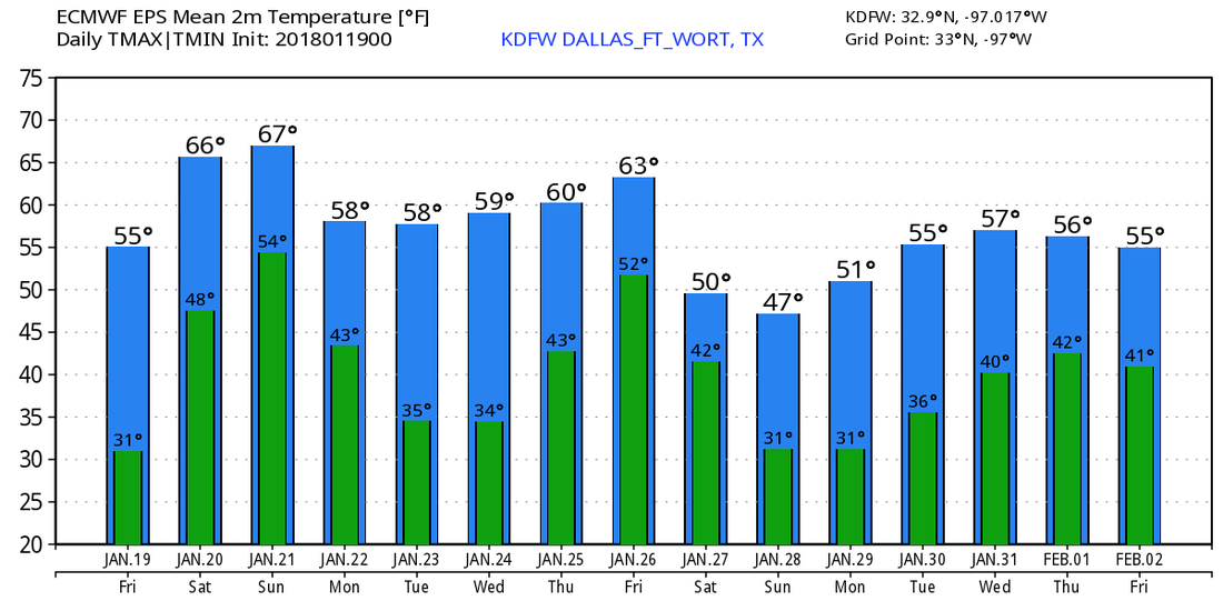 Another Frigid Morning - Once again, temperatures have fallen into the teens across North Texas... 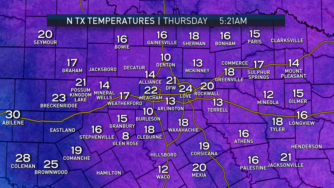 Thankfully, sunshine will be in full force today with highs in the mid 40s, so it shouldn't stay cold all day. Any ice still leftover should melt by the late afternoon hours. Friday and Saturday - We warm substantially on both days with Friday's high in the mid 50s (56) and Saturday's high in the upper 60s (68). We should stay very mild on both days with a few clouds. This is good for anyone that despises the cold weather. Sunday - We could see the possibility of a few showers and storms starting Sunday afternoon. The highest chance of marginally severe storms will remain to the east of Dallas. While damaging winds and a brief tornado or two will remain possible, meager instability values raises some uncertainties about the severity of the storms. For now, will continue to forecast marginally severe conditions for the Ark-La-Tex vicinity. The high on Sunday for DFW should be around 67. Next Week - Any rain potential for late next week is uncertain at this point. For now, next week looks generally dry and seasonably warm with highs generally in the upper 50s to low 60s, lows around 40. See the Texas Weather Discussion Video for more details. 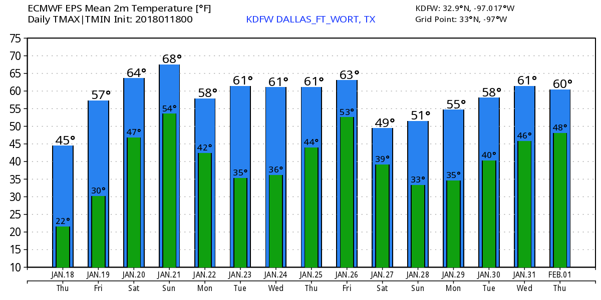 Frigid Temperatures - Temperatures are just absolutely unbelievable this morning. Some places have even dropped to the single digits this morning... 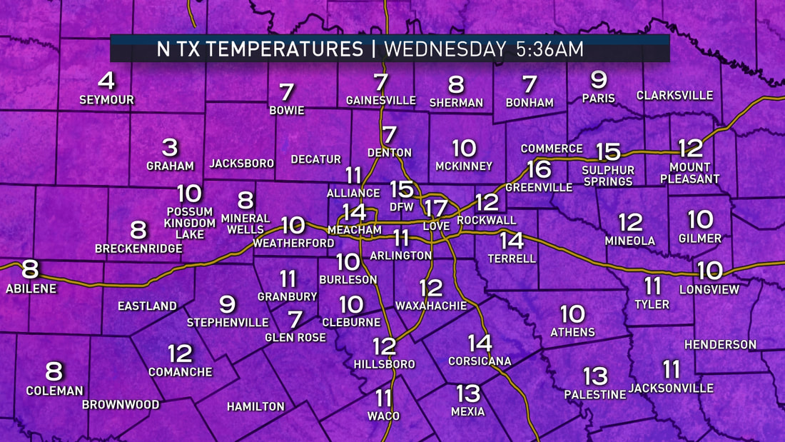 My weather station reads 11 degrees in Southeast Arlington... This is the new record low for DFW if we can drop two or three more degrees. Thankfully, there really isn't any ice on roads, but a few isolated spots may be a little slick.
One thing that is important when you head to work and school this morning is to bundle up big time. Any exposed skin in these frigid temperatures can cause frostbite or hypothermia in 30 minutes. We only warm to the mid 30s today, so continue to keep the winter gear handy throughout the day. Tomorrow should be much warmer; we start the day in the upper 20s, and we end up in the mid 40s. Any leftover ice at that time will melt during the afternoon. Friday and the Weekend - We should begin a rapid warm-up by Friday. It should be mostly sunny with a high of 58, Saturday will be ten degrees warmer, and Sunday will stay the same. Sunday is our next chance of showers and thunderstorms. A few storms could actually turn severe with mainly damaging winds, but a tornado or two can't be ruled out. We will continue to keep you posted as the day gets closer and the forecast changes. Next Week - We remain average in terms of temperatures, and next week should be generally dry with highs averaging to about 60. See the Texas Weather Discussion Video for more details. Radar Check - While moderate snow is continuing to fall to the east of Dallas, a few flurries remain possible in the DFW metro area... 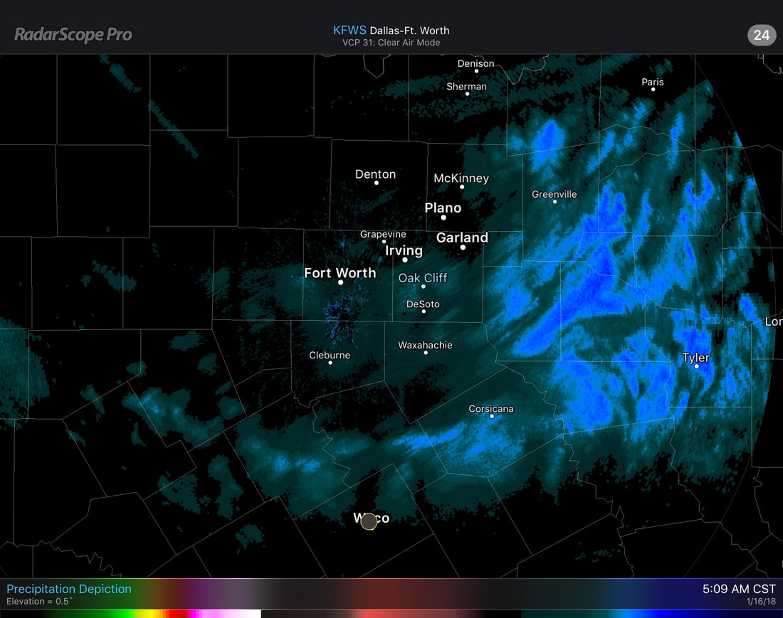 Anything that falls in DFW from here on out should not have a significant impact with travel. The precipitation should be completely out of North Texas by the afternoon. One thing to take note on this morning is the icy roads and cold temperatures. Please make sure you are exercising caution when traveling to work and school this morning. Thin ice may still be possible on bridges and some roads and could easily make you lose traction and spin off somewhere. Drive slow. Additionally, do bundle up for the rest of the day as it will be this cold going forward. The flu-season is out in full force, and the last thing we want is exposure to frigid temperatures to make the chance of catching it increase. 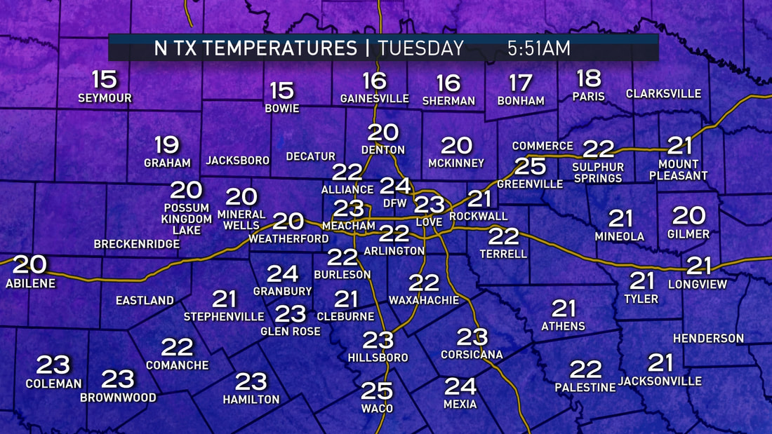 The high will only be in the upper 20s today with sunshine breaking out by the afternoon, which may help in melting some ice on roads. We trend even colder tonight, with widespread teens and single digits likely through the morning hours. Prepare your pipes, plants, pets, and people. Prolonged exposure to low temperatures outside will lead to hypothermia and frostbite in under 30 minutes. We will still be in the freezer for tomorrow with highs reaching the mid 30s. Some spots will stay below freezing for 48-60 consecutive hours. Thursday should be a little warmer with highs in the low 40s across North Texas. Any lingering ice around that time will melt. Friday and the Weekend - Friday should be another mostly sunny day with highs in the mid 50s. We warm even further on Saturday with highs reaching the mid 60s. A few spotty showers during the day can't be ruled out. And by Sunday, a surface front develops, which could bring the chance for rain and thunderstorms during the late morning hours. It remains known whether or not we see severe weather, but a storm or two could turn marginally severe. Next Week - We generally stay dry early next week, with potential for a potent storm system developing during the latter half of the week, which could bring out our next significant rain chances. See the Texas Weather Discussion Video for more details. 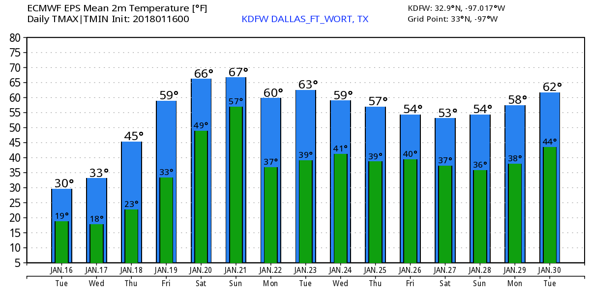 Sunny and Dry Today - Before we even get into the specifics about tonight into tomorrow, today will be a very sunny day with highs in the mid 50s by the afternoon. While many may not think much about this, this could turn into a bad situation for tomorrow; the pavement and other road surfaces will retain some of this heat, which leads to a potential major issue tomorrow. Wintery precipitation will begin to fall on the warmer surfaces, which will lead to initial melting, but with very cold air in place tomorrow morning (lows in the teens and single digits), we could see a flash-freeze tomorrow which could put a thin surface of ice on roads. Winter Storm Tomorrow - There is a Winter Weather Advisory in effect for... Fannin-Lamar-Collin-Hunt-Delta-Stephens-Palo Pinto-Parker-Tarrant- Dallas-Rockwall-Eastland-Erath-Hood-Somervell-Johnson, and Comanche counties... There is a Winter Storm Warning in effect for areas along and south of a line from Goldthwaite to Hillsboro to Sulphur Springs from midnight tonight until 6 PM Tuesday... 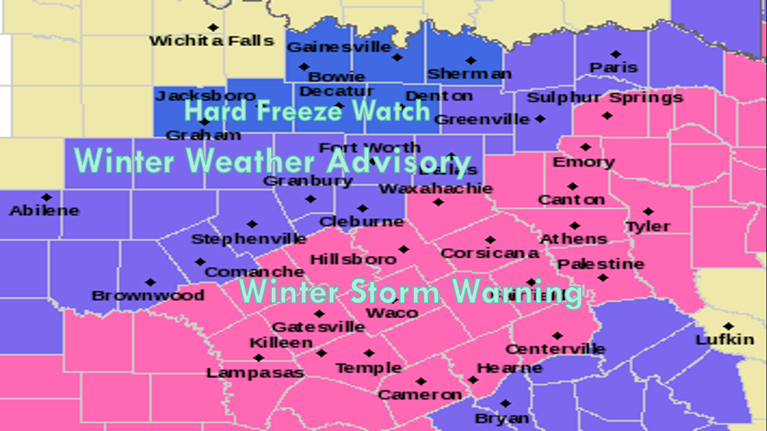 The DFW metro is not included in the winter storm warning due to snow amounts less than an inch, but do keep an eye out for any rapid changes. Timing - Rain will develop this evening at around 5-6 PM, with freezing rain developing around 8 to 9 PM. At this time, snow will most likely start to develop in the northern counties, with the onset for DFW during the midnight hours. 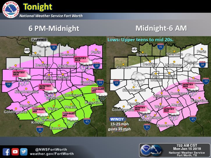 Totals - Keep in mind that snow amounts will be light with this event, with most places seeing 1" or less. By using the SREF ensemble model, we can determine that the range is from a "boom" value of 2.5 inches to a "bust" value of a trace, which is essentially nothing more than flurries. Any scenario is always possible. However, the mean is 0.44 inches for DFW. 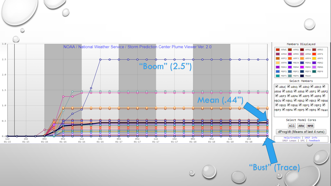 What Could Happen? - Despite the forecasted light snow amounts, there could be some significant impact. The snow will behind an arctic front, which will drop temperature into the teens (and some single digits) tomorrow morning. We will struggle to get out of the 20s all day. Keep in mind that the ice accretion process on roadways is VERY DIFFERENT in very cold air. This means that we could see some overnight melting at first, quickly followed by a very quick freeze which will lead to ice and very hazardous travel conditions. Please understand that road conditions could very quickly begin to deteriorate as early as past midnight, as the snow continues to fall. I really don't expect any improvements with the roads until Wednesday afternoon, where the sun will come out. When Can I Drive Again? - Sunshine should be back Wednesday with a high of around 35 degrees, which will help in the evaporation process that will improve travel by Wednesday afternoon, but some icy spots are still possible. Wednesday night will be cold as we drop to the teens by early Thursday morning, and we should warm to the low 40s by Thursday afternoon. Any ice still leftover will melt. School - I possess no special knowledge or skill about forecasting school closures/delays. That all depends on your school board's risk/travel tolerance, but please understand that roads will most likely be very hazardous to drive on beginning midnight as snow begins to fall. Watchful Eye - Remember, make sure that you are working with updated information as we get closer to this event. Remember, if you are looking at a forecast past six hours, you are using bad information. See the Texas Weather Discussion Video for more details.  |
Archives
April 2024
Categories |
 RSS Feed