
|
Sunny and Dry Today - Before we even get into the specifics about tonight into tomorrow, today will be a very sunny day with highs in the mid 50s by the afternoon. While many may not think much about this, this could turn into a bad situation for tomorrow; the pavement and other road surfaces will retain some of this heat, which leads to a potential major issue tomorrow. Wintery precipitation will begin to fall on the warmer surfaces, which will lead to initial melting, but with very cold air in place tomorrow morning (lows in the teens and single digits), we could see a flash-freeze tomorrow which could put a thin surface of ice on roads. Winter Storm Tomorrow - There is a Winter Weather Advisory in effect for... Fannin-Lamar-Collin-Hunt-Delta-Stephens-Palo Pinto-Parker-Tarrant- Dallas-Rockwall-Eastland-Erath-Hood-Somervell-Johnson, and Comanche counties... There is a Winter Storm Warning in effect for areas along and south of a line from Goldthwaite to Hillsboro to Sulphur Springs from midnight tonight until 6 PM Tuesday... 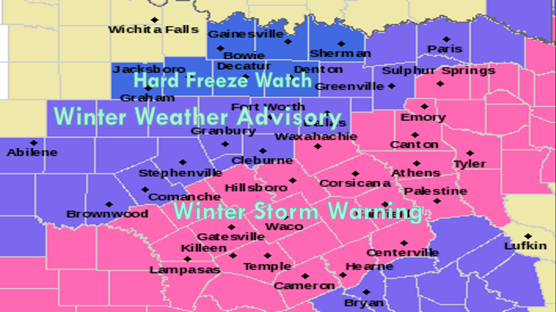 The DFW metro is not included in the winter storm warning due to snow amounts less than an inch, but do keep an eye out for any rapid changes. Timing - Rain will develop this evening at around 5-6 PM, with freezing rain developing around 8 to 9 PM. At this time, snow will most likely start to develop in the northern counties, with the onset for DFW during the midnight hours. 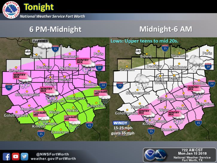 Totals - Keep in mind that snow amounts will be light with this event, with most places seeing 1" or less. By using the SREF ensemble model, we can determine that the range is from a "boom" value of 2.5 inches to a "bust" value of a trace, which is essentially nothing more than flurries. Any scenario is always possible. However, the mean is 0.44 inches for DFW. 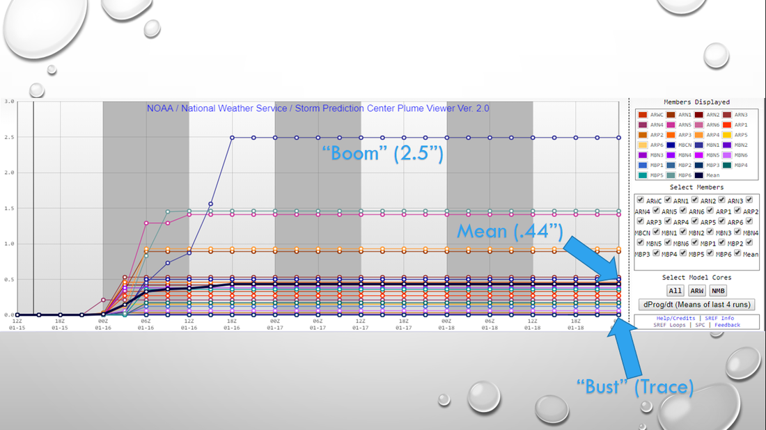 What Could Happen? - Despite the forecasted light snow amounts, there could be some significant impact. The snow will behind an arctic front, which will drop temperature into the teens (and some single digits) tomorrow morning. We will struggle to get out of the 20s all day. Keep in mind that the ice accretion process on roadways is VERY DIFFERENT in very cold air. This means that we could see some overnight melting at first, quickly followed by a very quick freeze which will lead to ice and very hazardous travel conditions. Please understand that road conditions could very quickly begin to deteriorate as early as past midnight, as the snow continues to fall. I really don't expect any improvements with the roads until Wednesday afternoon, where the sun will come out. When Can I Drive Again? - Sunshine should be back Wednesday with a high of around 35 degrees, which will help in the evaporation process that will improve travel by Wednesday afternoon, but some icy spots are still possible. Wednesday night will be cold as we drop to the teens by early Thursday morning, and we should warm to the low 40s by Thursday afternoon. Any ice still leftover will melt. School - I possess no special knowledge or skill about forecasting school closures/delays. That all depends on your school board's risk/travel tolerance, but please understand that roads will most likely be very hazardous to drive on beginning midnight as snow begins to fall. Watchful Eye - Remember, make sure that you are working with updated information as we get closer to this event. Remember, if you are looking at a forecast past six hours, you are using bad information. See the Texas Weather Discussion Video for more details. 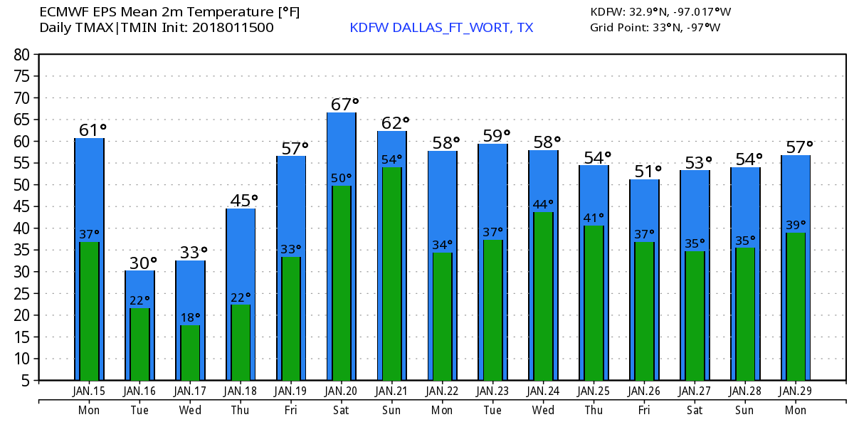 |
Archives
March 2023
Categories |
 RSS Feed
