
|
CLASSIC SUMMERTIME WEATHER - This is the time of the year where you can say the weather for Dallas, Texas will be hot and humid with sunshine in full force during the afternoon and be accurate 99.9% of the time. This is the case again and tomorrow for North Texas. The high today will be in the triple digits for most areas. THE WEEKEND - The weather will not change much. Everyday will feature abundant sunshine with afternoon highs in the upper 90s. Pretty typical late June/early July weather. NEXT WEEK - We will continue to role with a consistent forecast for much of the Independence Day week. Nothing to indicate something that will bring enough moisture for rain development, so we will have abundant sunshine all throughout the day. Highs will be in the upper 90s. See the Texas Weather Discussion Video for more details. 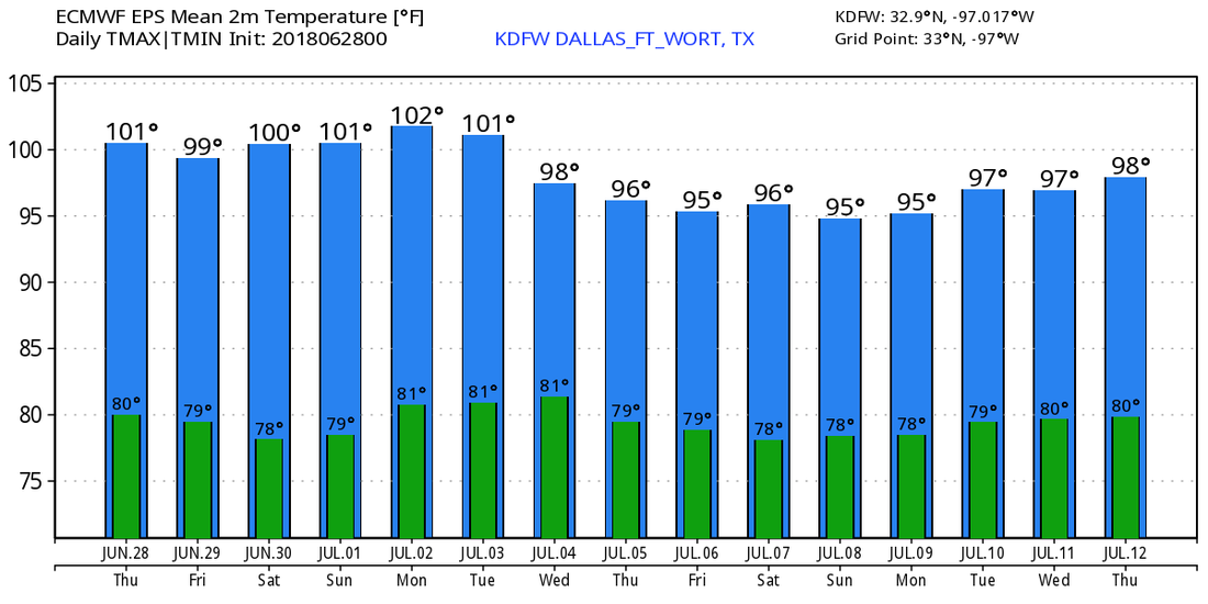 TROPICS - All is quiet in the Atlantic Basin, and no new tropical cyclones are expected for the next week.
It's that time of the year where the weather doesn't change much. It must be summer down here in the Lone Star State. It will be yet another hot summer day with highs at or near the century mark. Heat indices could reach the 105 degree mark in most areas, so make sure you are continuing to practice heat safety. REST OF THE WEEK AND THE WEEKEND - The overall pattern really doesn't change much. The weather will feature pretty much more of the same thing; mostly sunny, hot, humid days with highs in the upper 90s to near 100. Sounds like typical late June/early July weather in Texas. NEXT WEEK - The overall weather pattern will not change next week. Subsequently, the weather will stay the same through most of next week with hot, humid days with highs just at or near the century mark. Like I said before, this is to be expected when we get into July. See the Texas Weather Discussion Video for more details. 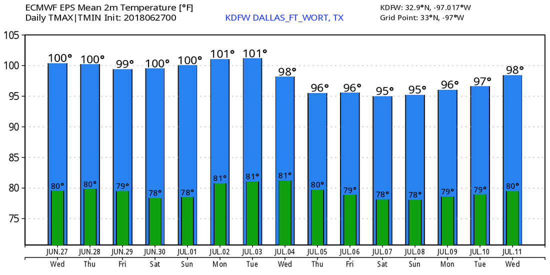 TROPICS - A weak area of disturbed weather is located off of the North Carolina coast. It is not expected to develop at all. The rest of the Atlantic Basin remains very quiet.
TYPICAL SUMMER WEATHER - It's a new day but feels like an old forecast. It must be summer time in the Lone Star State. Today's weather will be just like the previous days; hot and humid with sunshine in full force during the afternoon and evening hours. The high will be in the upper 90s to the near century mark in most places. REST OF THE WEEK - Not much change. We remain very hot and humid with sunshine still in full force in the afternoon and evening. The afternoon high will still be in the upper 90s. THE WEEKEND - Same thing. Most of the sun will be out all day and the afternoon and evening hours. The afternoon high will weaken to the mid 90s this weekend, but we probably won't feel the difference as a result of the humidity levels. JULY 4TH WEEK - Nothing of significance in the forecast next week. Sunshine in full force, very hot, humid days with highs in the mid to upper 90s. See the Texas Weather Discussion Video for more details. 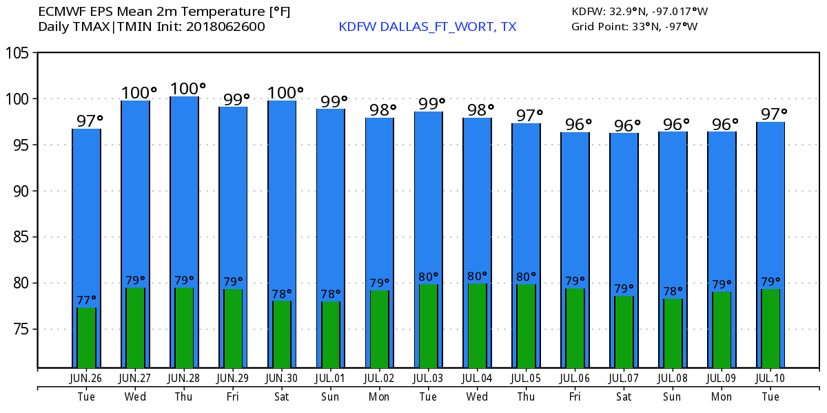 TROPICS - There is an area of disturbed weather in Central North Carolina that has a 20 percent chance of becoming a tropical cyclone within the next five days. This system is expected to form an area of low pressure as it progresses eastward towards the open water. No impact to land. The rest of the Atlantic Basin remains quiet.
SUNNY, MILD, & HOT - We are approaching that time of the year when you can say those three words and get the forecast right every day. Broad ridging will stay in place for much of the south-central US for the week which will continue to induce typical summer-time weather for Texas. Keep in mind that it will be hot everywhere in Texas and not just North Texas. Noticing the difference between temperature gradients this time of the year will be very difficult due to similarities in heat levels and moisture levels. Temperatures will be in the upper 90s with some in the century mark with only a few clouds. FOR THE REST OF THE WEEK - Not much change in the weather pattern here in North Texas. Hot, mild, sunny days with more sun than clouds. Afternoon highs in will be very close to the century mark everyday with heat indices in the 100-105 degree range. THE WEEKEND - Still sunny and very hot across the state. Mostly sunny days with hot and humid conditions with highs in the upper 90s to low 100s. No need to change the forecast for next week as we get closer to the Fourth of July. See the Texas Weather Discussion Video for more details. 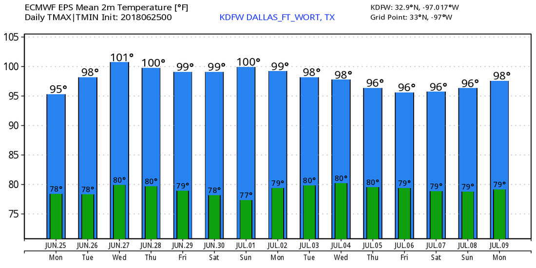 TROPICS - The Atlantic Basin remains very quiet, with no tropical cyclone activity expected for the next week.
We continue to track a boundary that should be the focus for scattered severe storms this evening in Oklahoma. These storms are yet to really sustain, so we will watch if these can even develop. There is also an area of concern is western parts of Texas that a few storms may travel into our area later tonight...
These storms through about 10PM should continue to grow into a cluster, and could turn severe with large hail and damaging winds, assuming they develop. These storms will move into North Texas but should be weakening as they close in on the DFW metroplex as they will run into an area that's less supportive of severe weather given the forecasted increase of convective inhibition that should arise in the metroplex. HOWEVER, it's still possible for a few severe storms in the metroplex and the entire forecast for this evening strongly depends on whether these storms out west and north can develop and how intense they are able to be etc... will place 30% storm chances for the metroplex and higher chances NW of the area... I don't have any widespread storms or any widespread severe weather in my forecast at this time. We will watch a cluster of storms that will also move across Oklahoma during the morning hours tomorrow that might have a small impact on our local area getting clipped by this system. Will have silent 10-20% chances of rain tomorrow... most if not all of North Texas should stay dry. We will dry out and heat up next week with a fairly boring pattern. Any nocturnal MCS should stay away from North Texas next week, but we will watch if any trend develops for sometime next week. Jonathan Williams *no Texas Weather Discussion Video due to Drum Major Camp week* Our latest radar imagery this morning over North Texas shows scattered showers and thunderstorms located over the western and central part of the region, followed by a large rainmass over much of east Texas moving northward in association of a weak tropical disturbance in South Texas. The surface map continues to show a surface front positioned from Nevada through the mid-Atlantic states. Most of the rain today will be in the great Lone Star State as we continue to get deep moisture from the weak tropical system and as the frontal system marches southward. Highs should be in the upper 80s again with frequent breaks from the clouds. Scattered showers and thunderstorms will be common throughout the day. 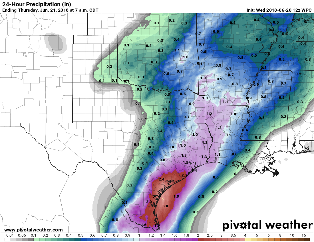 The SPC is forecasting a marginal risk of severe thunderstorms for areas pretty much along the frontal boundary. Damaging wind and large hail at times can be expected.  Nothing to see out in the tropics because the Atlantic Basin and the Eastern Pacific remain quiet. Going to our upper air observations, that ridge that has been in place over the Southeastern US for quite some time will be weakening over the next couple of days as a upper low and associated trough and storm system moves eastward out of Nebraska over the coming days. That is why moisture is more freely flowing across Texas this morning. However, that won't really affect our weather going forward through the rest of this week. We will quickly catch up to summer again with afternoon highs in the mid 90s again, followed by some triple-digit heat by Friday with mostly sunny skies. Interesting to note that the GFS does print widespread 100 degree weather for Texas as we head into Friday evening... 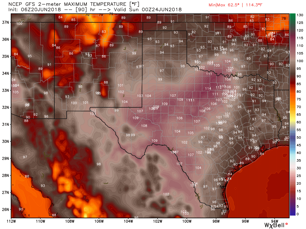 So really after today, we transition to our usual summer pattern with mostly sunny skies with a few clouds and a chance of an isolated storm or two during the afternoon and evening hours. Humidity values will drop back into the 50-60 percent range as well. For next week, same thing. Mix of sun and clouds with afternoon highs in the mid to upper 90s with a chance of afternoon and evening showers and thunderstorms. Not really a need to elaborate on typical summer time weather in Texas. So that's about it for today. I will try to have a blog out for tomorrow and Sunday, but I will be gone for Drum Major camp starting tomorrow. So the timing of blog posts may vary. Enjoy your hump day! Make sure to make someone smile today! Donovan Neal  Much of the North Texas region appears sunny this morning, although clouds from the disturbance in the Texas Coast is affecting much of North and Central Texas. Broad ridging remained in place yesterday afternoon and this morning, which precluded a more widespread rain event. WIth broad ridging still in place today, it appears very likely that any showers and thunderstorms will remain very spotty and limited in coverage today. Highs should be in the upper 80s to low 90s today. The broad ridge that is currently in place for much of the south-central US will be weakened by the approach of a surface front from the northwest on Wednesday. That front will slowly move towards the northern part of Texas as we get towards Friday and the weekend as a closed low weakens the area of high pressure over the southeast US. As we go down towards the surface, an area of high pressure builds over the four corners region during the latter half of the week, which will do a good job of pushing the surface front down into Texas. Although Precipitable Water values will be in the 2-2.5 inch category, the eastern side of the coverage area will have the best chances of rain as we are sandwiched in between drier air and a moist airmass. We will still mention the chance of scattered showers and thunderstorms during the day today and tomorrow as coverage decreases Thursday and Friday. 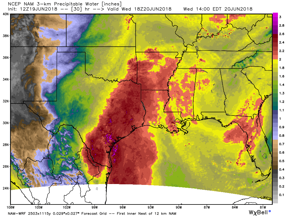 One good thing about all of the cloud cover that we probably don't notice is that it does a good job of keeping highs just out of the 90s today and tomorrow and maybe Thursday. But, we probably won't notice that as a result of the higher humidity levels. Looking out into the Atlantic Basin, it remains quiet with of course the exception of the area of disturbed weather near Corpus Christi. Areas surrounding that and near Houston will see lots of rainfall over the next seven days with amounts of over 7 to 10 inches. For North Texas, amounts will be very limited and spotty due to the scattered nature of the showers and thunderstorms. Amounts of around 0.5 to 1 inch can be expected. 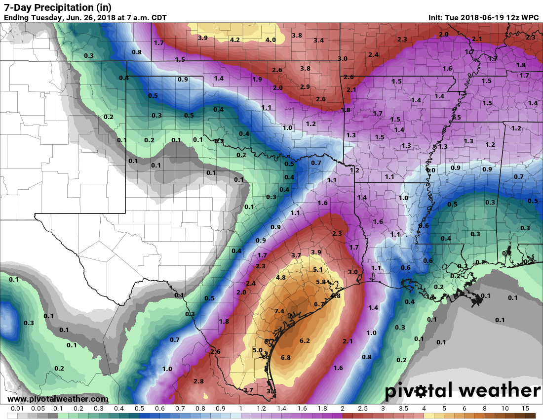 From the weekend through the early half of next week, the surface front lifts back to the north after it pulls down a drier airmass for Texas. Highs will go back to the mid 90s with a mix of sun and clouds. Taking a sneak peak past ten days, the GFS shows normal heights for North Texas closing the month of June, which also indicates a little shortwave trough in the four corners region which could open the door for scattered showers during that time period. We turn dry for early July, with a substantial ridge and heat bubble building over the eastern half of the US. I don't think we will be too hot as a result of normal heights here in North Texas. So that's really about it. Regardless of rain or cloud cover, make sure you are still practicing heat safety wherever you may be. Also, PLEASE don't forget about your kids and dogs; don't please don't be that cruel human being that locks them in a hot car for any period of time. Enjoy your Taco Tuesday! Donovan Neal.  *No Texas Weather Discussion Video due to break week* It wasn't particularly active on Sunday across North Texas with only a few scattered showers and thunderstorms about for the region. However, the radar this morning shows scattered showers about in North Texas, clustering near Hillsboro.  It is also noted that there is a field of widespread cumulus clouds across much of the Lone Star state as a result of the tropical moisture associated with Invest 91L. The sun will still be out at times, but expect clouds to accompany the sunny weather. Random, scattered showers will be possible throughout the day, especially during the afternoon and evening hours. Temperatures are in the upper 70s to low 80s across the region. Expect afternoon highs in the low 90s today. With the storm track and the main mid-latitude westerlies to the north of us, the SPC has a slight risk of severe thunderstorms over the northeast states, including parts of Nebraska, Colorado, and Iowa. For tomorrow, the SPC has a large area of marginal risk of severe storms from the Texas Panhandle through most of the Central Plains, extending into much of Virginia. On Wednesday, an area of upper low pressure will develop in Nebraska with a cold front extending through the Texas Panhandle. A marginal risk is maintained from Northwest Texas through Central Iowa. Looking out in the tropics, the Atlantic Basin remains very quiet with the exception of one area of disturbed weather in the northern Gulf. At this type, this system is not expect to develop into a tropical cyclone, but it will serve as a moisture pump for Texas. Rain amounts of about a foot or more can be expected from this system through this week. 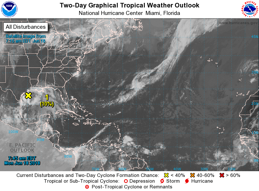 Taking a quick height analysis real quick, we have broad ridging in place for much of the southeastern U.S with a trough approaching from the southwest. That trough will weaken the ridge to the east by Wednesday, which will open the door for a cold front to come through during the latter half of the week. Precipitable water values should stay in the 1.5 - 1.9 range today, so we will only see a few scattered showers and thunderstorms during the afternoon and evening hours with highs in the low 90s. However, as we head into tomorrow, PWAT values climb to 2.0 for much of the region as well as 2.0-3.0 for the following days. Showers and thunderstorms should become more numerous Tuesday, with more coming Wednesday as well. Rain-cooled air as well as widespread clouds for much of the region should do a good job in keeping us in the 80s for Tuesday and Wednesday. With the cold front coming through, we will start to dry out a little, but with the front, we will need to continue with a chance of at least isolated showers and thunderstorms for Thursday and Friday. We start to warm up on Friday with afternoon highs in the mid 90s. The surface front really doesn't go anywhere during the weekend, so we will also mention the chance of isolated showers and thunderstorms during the weekend. The sun starts to come out more often, and afternoon highs will be in the mid 90s with morning lows in the mid 70s.' Looking at the Quantitative Precipitation Forecast for the next week, obviously the heavier totals will remain concentrated in near the Texas coast where a foot of rain or more can be expected. For North Texas, amounts of up to two inches can be expected with locally heavier totals. 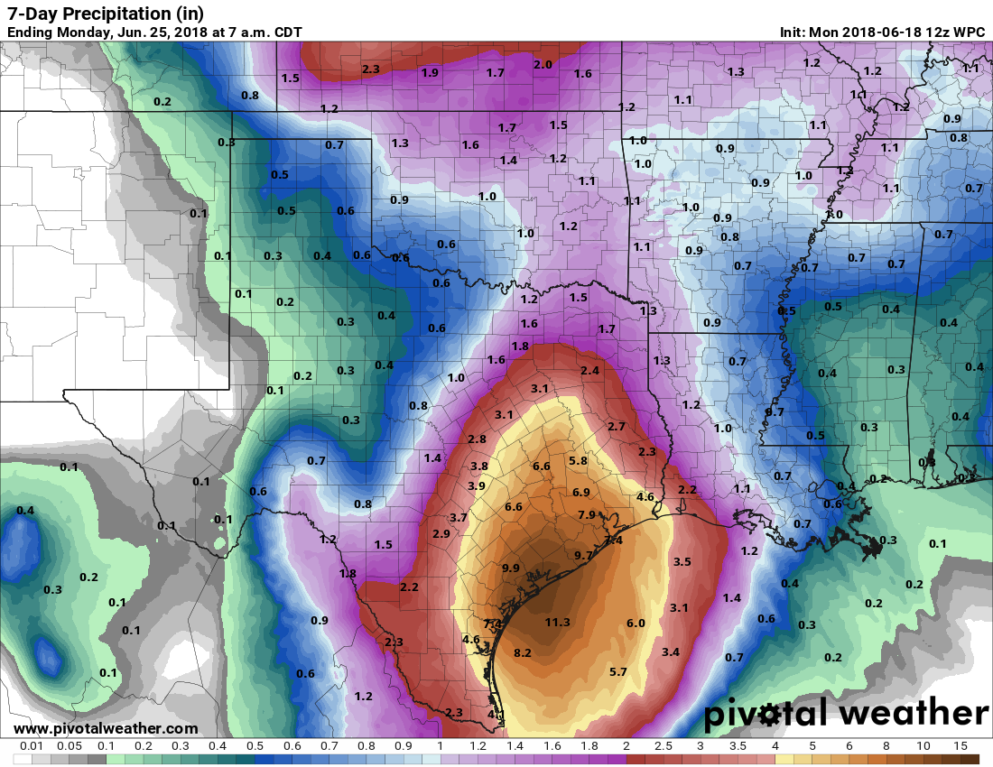 Looking out into the early parts of next week, we revert back into the classic late June pattern to close out the month. Highs will be in the mid to upper 90s with mostly sunny skies.
Look for the next blog update tomorrow by noon! Donovan Neal. After a long & hot dry stretch, that trend will be ending this week...
2 Tropical waves have developed in the Gukd of Mexico and we are closely watching. These will enhance rain chances across our region during the week! We expect our best chances of rain to come Monday and Tuesday. This is when scattered (40-60%) showers and thunderstorms will develop in the area. Severe weather is not expected, although the strongest storms may produce 40mph wind gusts and heavy rain along with frequent lightning. Wednesday we will continue with the storm chances near 30%, but locations that do see storms could see some very heavy yet beneficial rainfall. By Thursday and Friday our attentions turn to the north as a disturbance and a boundary drop south. This may aid in a threat of a few complexes of storms during this time. The severe potential is unknown and will be processed in further detail in the coming days... therefore we will insert 30% POPS later next week. We should dry out by next weekend with the hot and dry pattern coming back once again... I am excited to be the weekend forecaster for APEX WEATHER! Jonathan Williams NEW DAY, SAME FORECAST - The overall forecast won't really change today through the weekend; hot, breezy days, fair nights with afternoon highs mostly in the mid to upper 90s. Any potential for afternoon isolated showers and thunderstorms will be confined to our southeastern counties, but most will stay dry today through the weekend. Robust tropical moisture begins to advect from the Gulf on Sunday, but won't really arrive until Monday. We will still continue to mention the chance of isolated showers and thunderstorms on Sunday with highs in the low 90s. NEXT WEEK - Deep, tropical moisture reaches the Lone Star State from the west and the south, which also means long-term drought areas will see somewhat of relief next week. Highs will mostly be in the upper 80s with scattered showers and thunderstorms most likely on Monday and Tuesday for North Texas. It is hard to forecast exact start/stop times of the thunderstorms due to the random nature of them. The best chance of any one spot getting wet will be in the 50/50 range. If you have any outdoor activities, plan for it to rain at any time on Monday and Tuesday. We will continue to mention the chance of isolated showers and storms on Wednesday, but we start to clear house on Thursday. Rain totals will be in the 1 to 1 1/2 inch category for areas that do receive rain. The sky will be mostly cloudy on most days. See the Texas Weather Discussion Video for more details.  TROPICS - A broad area of low pressure is currently located near the Yucatan Peninsula today. It will continue to move into the Bay of Campeche later this evening into tonight. This should not develop into a tropical cyclone, but will indeed push beneficial moisture into Texas this weekend. The rest of the Atlantic Basin stays quiet.
On our left hand, Bud is still hanging on as a tropical storm as it approaches Baja California from the south. It is forecast to dissipate this weekend, but, it will push moisture into the southwestern parts of the U.S, including West Texas and the panhandle, where the worst of the drought is taking place. NOTHING OUT OF THE ORDINARY - Another typical late morning here in the great Lone Star State; more sun than clouds, winds at a calm level with temperatures in the mid to upper 80s. We will once again be in the mid to upper 90s later this afternoon with plenty of sunshine. Nothing really changes for the rest of this week or the weekend; hot and breezy days, fair nights, highs in the mid to upper 90s with more sun than clouds. WET WEEK AHEAD - Tropical moisture will advect from the Gulf this weekend, which will create statewide chances of showers and thunderstorms on Sunday through the much of next week. Rain will become more widespread on Monday with plenty of moisture, then we will continue to mention the chance of scattered thunderstorms for most of the week. Since they are more scattered in nature, it will be nearly impossible to forecast exact start/stop times. Just know that we will be under the gun for some rain starting Sunday afternoon. If you have any outdoor plans next week, just keep a close eye on the radar. Highs will be in the upper 80s to low 90s due to rain-cooled air. See the Texas Weather Discussion Video for more details. TROPICS - A disorganized batch of showers and thunderstorms in the Western Caribbean Sea will move northwest into the Southwest Gulf of Mexico later this week. Development looks highly unlikely, but it will push deep tropical moisture into the state during the weekend, bringing beneficial rain for much of Central and North Texas. The rest of the Atlantic Basin remains quiet.  On our left hand, Bud has weakened to a tropical storm earlier this morning as it interacted with cooler water. This system will bring rain to the southern tip of Baha, California as it pushes to the northwest towards the southwest parts of the U.S this weekend. 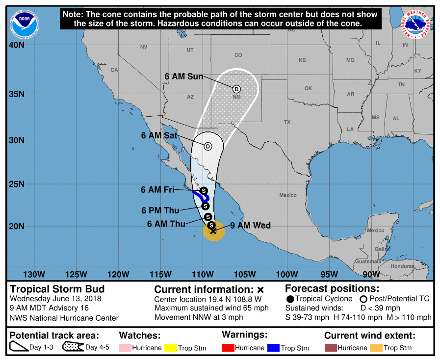 CLASSIC JUNE MORNING - The day is new, but the forecast feels old this morning with temperatures in the mid to upper 80s. This afternoon will be no different with afternoon highs in the mid to upper 90s with a mix of sun and clouds. However, we are monitoring a complex of showers and thunderstorms in Central Oklahoma that are progressing to the south. The main concern is that if this verifies, we will see some of those thunderstorms move into the North Texas area. Some could be on the strong side with a chance of mainly damaging winds and a hail risk. We do note that the SPC has a marginal risk of severe thunderstorms for much of the DFW metroplex.  Just know that not everyone will see rain, and the best chance of any one spot getting wet will be in the 50 to 60 percentile. After today, the forecast for the rest of the week will not chance that much. More sun than clouds with afternoon highs in the mid to upper 90s with morning lows in the mid 70s. THE WEEKEND - Most of the weekend stays dry for the most part. By Sunday evening, moisture will continue to advect from the Gulf, which will spread into much of Texas through the early part of next week. But most of the weekend stays dry with highs in the low to mid 90s. NEXT WEEK - The early part of next week will feature scattered to numerous showers and thunderstorms with tropical moisture moving to the north. Right now, the main concern is heavy rain at times, and the best chance of any one spot getting wet will be in the 50/50 percent range for now. Isolated thunderstorm chances will continue to the latter half of the week. Highs will be in the low 90s due to rain-cooled air. See the Texas Weather Discussion Video for more details.  TROPICS - A broad area of disorganized showers and thunderstorms is located in the western Caribbean Sea. It will continue to progress northwestward towards the Lone Star State. NHC only gives this a 20 percent chance of developing within the next five days. However, this will most likely only bring moisture and beneficial rains to our state without becoming a tropical cyclone.  Going to the eastern Pacific, Hurricane Bud is now a category three storm with maximum sustained winds of 125 mph. It will start to weaken later today as it progresses towards Baja California within the next two to three days. By that time, the main threat will be heavy rain. Some of the moisture associated with the remnants of Bud could work its way towards southwest US during the weekend and the early parts of next week. 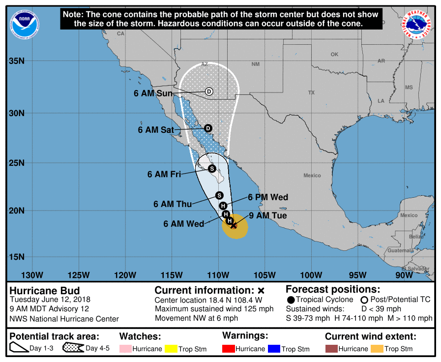 TYPICAL JUNE WEATHER - We are getting into the part of the year when the forecast really doesn't change that often. Hot, breezy days with sunshine in full force with a chance of an isolated shower or thunderstorm, mainly during the afternoon and evening hours. This is pretty much the same forecast through Friday. Highs will be in the 92-98 degree range with the chance of one spot getting wet in the 10-20 percentile. THE WEEKEND - Not much change. We will continue to see hot, breezy days with fair nights through the weekend. Highs will continue to be in the 93-96 degree range. NEXT WEEK - Moist, unstable air emerges from the Gulf and covers much of North and Central Texas, which means we will need to mention the chance of scattered showers and thunderstorms for the early part of next week. We will see a mix of sun and clouds with highs in the low 90s through Wednesday. The latter half of next week should clear to dry conditions with afternoon highs in the low to mid 90s. See the Texas Weather Discussion Video for more details.  TROPICS - The Atlantic Basin continues to remain quiet. However, in the Central Pacific, Hurricane Bud is now a category three hurricane with sustained winds of 120 mph. It will continue to inch towards the island of Baja later this week as a weakening tropical storm. Gusty winds could occur, but rain would be the main issue.  HEAT LEVELS CONTINUE TO STAY THE SAME - We are forecasting a high in the 93-97 degree range for much of the North Texas region this evening, very similar to the past few days. Sunshine will remain in full force, and while there could be a couple of showers and thunderstorms on the radar, they will be "few and far between". The chance of one spot getting wet is only in the ten to twenty percent bracket. THE WEEKEND - Tomorrow will be the same as recent days; fair nights, hot, humid, and breezy afternoons, highs in the low to mid 90s, which is only a few degrees above the average high for early June. The sky will feature more sun than clouds. NEXT WEEK - Not much change. A routine June weather pattern will stick with us through most of next week; hot and breezy afternoons, comfortable nights with highs in the mid 90s and lows in the mid to upper 70s. In terms of the model madness concerning next week's potential tropical situation in the Gulf, the GFS continues to show the potential for a tropical low of some sort to form somewhere near the Caribbean and the Gulf during the latter half of next week. The 06Z run takes that same system or tropical low to Central Florida by Monday morning. Meanwhile, the European model consistently shows absolutely no activity in the Gulf or the Caribbean. As always, we will side with the European model solution and continue to ignore the GFS at this present time. See the Texas Weather Discussion Video for more details. 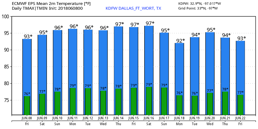 TROPICS - The Atlantic Basin continues to remain quiet. Meanwhile, Hurricane Aletta reached Category Four strength this morning over the Eastern Pacific. It is moving westward, and poses no threat to land. 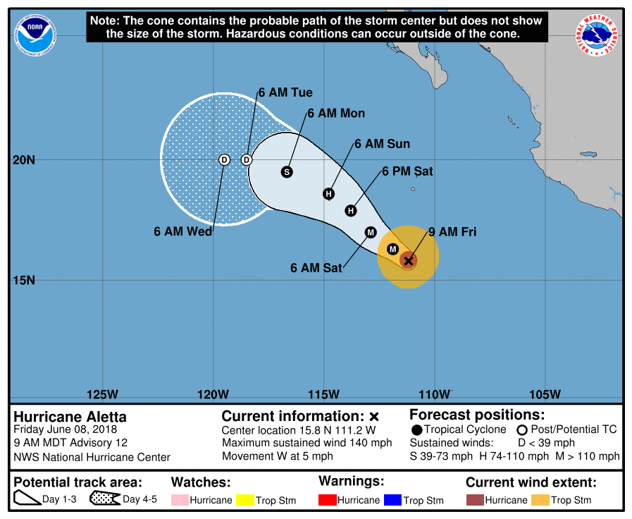 HOT CONDITIONS CONTINUE - While temperatures are in the middle to upper 80s right now, we are continuing to project highs in the middle 90s later this afternoon and tomorrow as well with mostly sunny skies each day. While the chance of any one spot getting wet is not zero, and isolated shower or storm that happens to form will be few and far between. THE WEEKEND - Not much change for the weekend. We will continue with the typical June weather pattern with mostly sunny skies with hot and humid conditions. Any thunderstorm that happens to develop will be random, mostly during the afternoon and evening hours. Highs for the weekend should be just at or above the 95 degree range. NEXT WEEK - An area of high pressure will continue to build over Central Texas, which puts us in a dry slot for much of next week. Hot and humid days with lots of sunshine are in the forecast. Highs should be in the 92-98 degree range. WILL WE SEE BERRYL?? - The GFS has been consistently showing the progression of a developing high-end tropical storm/low-end hurricane moving north towards Mobile, Alabama Thursday night/early Friday morning of next week. However, the European model shows a big full bag of nothing. Do note that the European model is the most reliable model in these situations, so we will continue to buy that solution and monitor any changes. See the Texas Weather Discussion Video for more details. 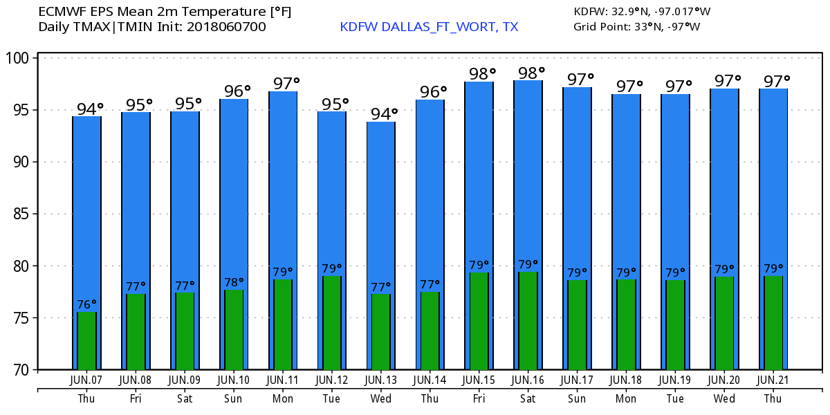 TROPICS - The Atlantic Basin continues to remain quiet over the next week. However, if we look to our left, over in the Eastern Pacific, Tropical Storm Aletta is forecast to become a hurricane later this evening. Maximum sustained winds are already at 70, but it will continue to churn in open water with no threat to land. 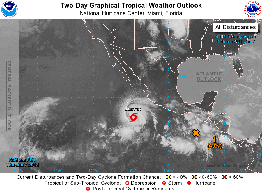 ANOTHER VERY WARM AFTERNOON - Temperatures are in the upper 80s to low 90s just before 1PM. Expect more sunshine with an increase in the temperature by about a few degrees during the late afternoon hours. This is the time of the year when we forecast the chance of a random, pop-up isolated thunderstorm for the region. We will not be in a volatile airmass like yesterday, so a localized severe weather event is not anticipated, but any storm could produce a heavy downpour, frequent lightning, gusty winds, and a hail threat. TOMORROW AND FRIDAY - Not much change. Dry air stays in place through the region with sunny days and fair nights. Highs will remain in the middle to upper 90s with the heat index in the 100 degree range. THE WEEKEND - Dry air continues to stay in place for the region, which will lead us to a dry forecast through the weekend with more sun than clouds. Again, any isolated storm that forms will have the potential to turn strong to severe. The best chance of one spot getting wet is in the ten to twenty percent bracket. Highs will continue to be in the middle to upper 90s. NEXT WEEK - Our typical June pattern will continue to stay the same through next week. Mostly sunny skies, fair nights. Any thunderstorm that forms will be random and will pose a threat for lightning, downpours, gusty winds, and hail. Highs will remain in the mid to upper 90s for much of the week. See the Texas Weather Discussion Video for more details. 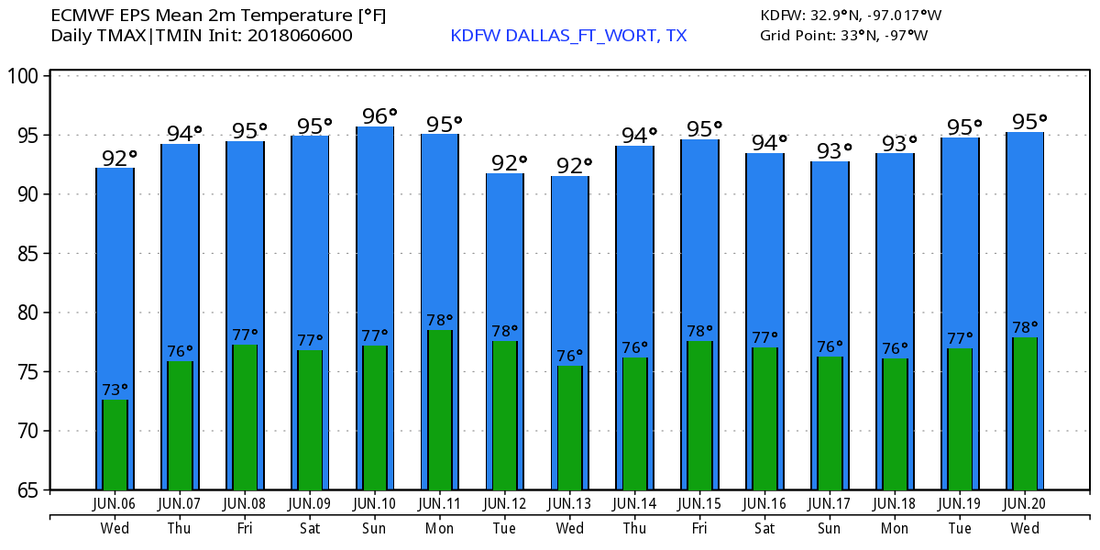 TROPICS - The Atlantic Basin will continue to remain quiet for the next week, and tropical cyclone formation is not anticipated. However, if you go to the Central Pacific, we have Tropical Storm Aletta, the first tropical storm of the season. It is forecast to become a hurricane tomorrow evening, but will move out to see and stay far away from land.
NICE LATE MORNING - Many stations across the metroplex report 80 degrees or higher just before noon this morning. We are also seeing temperatures in the 70s off to our east. With drier air filtering in from the northwest, we will warm to the low to mid 90s this late afternoon. After the storms, we see a nice layer of high cirrus clouds, but they should remain on the light side and sunshine will be in full force today. A couple of lingering cells from the north will dissipate over time and will not affect the North Texas area this morning. 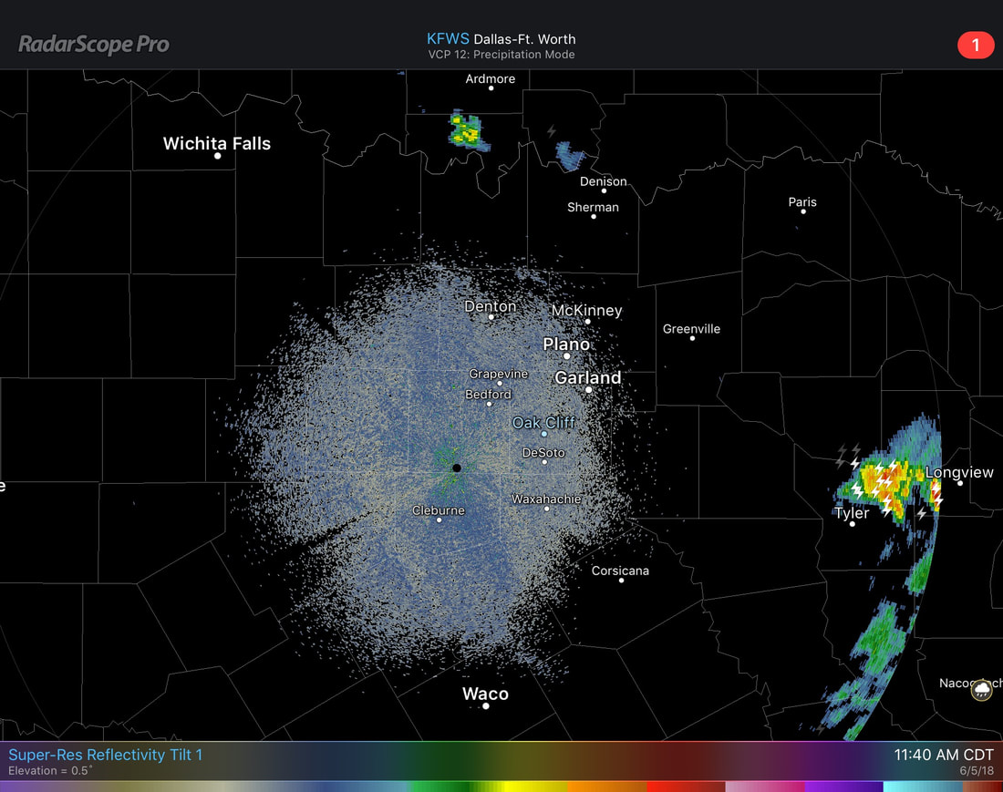 MIDWEEK - Not much change in the forecast. Rain-free weather will continue with a dry airmass in place for North Texas. Highs will be in the middle to upper 90s during the afternoons. THE WEEKEND - Looks like the weekend will be perfect for outdoor activity with abundant sunshine and a dry airmass. Highs will stick in the mid to upper 90s. NEXT WEEK - Typical June week ahead with very warm days and fair nights and a dry airmass. Highs will be in the mid to upper 90s. See the Texas Weather Discussion Video for more details. 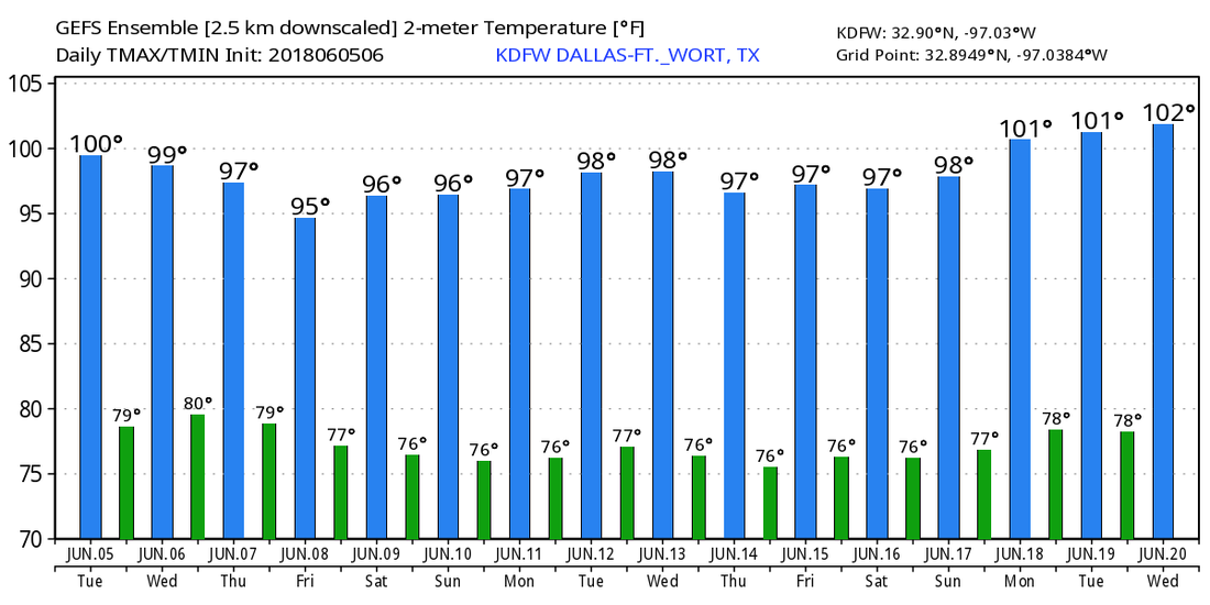 TROPICS - Tropical storm formation is currently not expected for the Atlantic Basin through the early part of next week.
RADAR CHECK - The heaviest rain has weakened and moved off to the northeast past Dallas. Another batch of rain from the west has weakened and has since dissipated.  We get a nice breath of fresh air from a rare June cold front that passed through early Sunday morning, producing scattered showers and thunderstorms in New Mexico and West Texas which eventually moved through North Texas this morning. Following the storms, we have a nice surge of dry, continental air moving into our region from the west. We will stay mostly cloudy today with a high in the 82-86 degree range due to rain-cooled air. Dewpoints are in the middle 60s right now, so go out and enjoy the weather because these are low humidity values for a summer day. We will likely see another complex of showers and thunderstorms tomorrow morning during the pre-dawn hours as they develop somewhere in the region or somewhere in Southern Oklahoma. Some of those storms could be strong, posing the threat for isolated damaging wind gusts and hail in some spots. It is worth noting that the SPC has much of North Texas under the "marginal risk" (1/5) of severe storms for the rest of today and tomorrow morning. 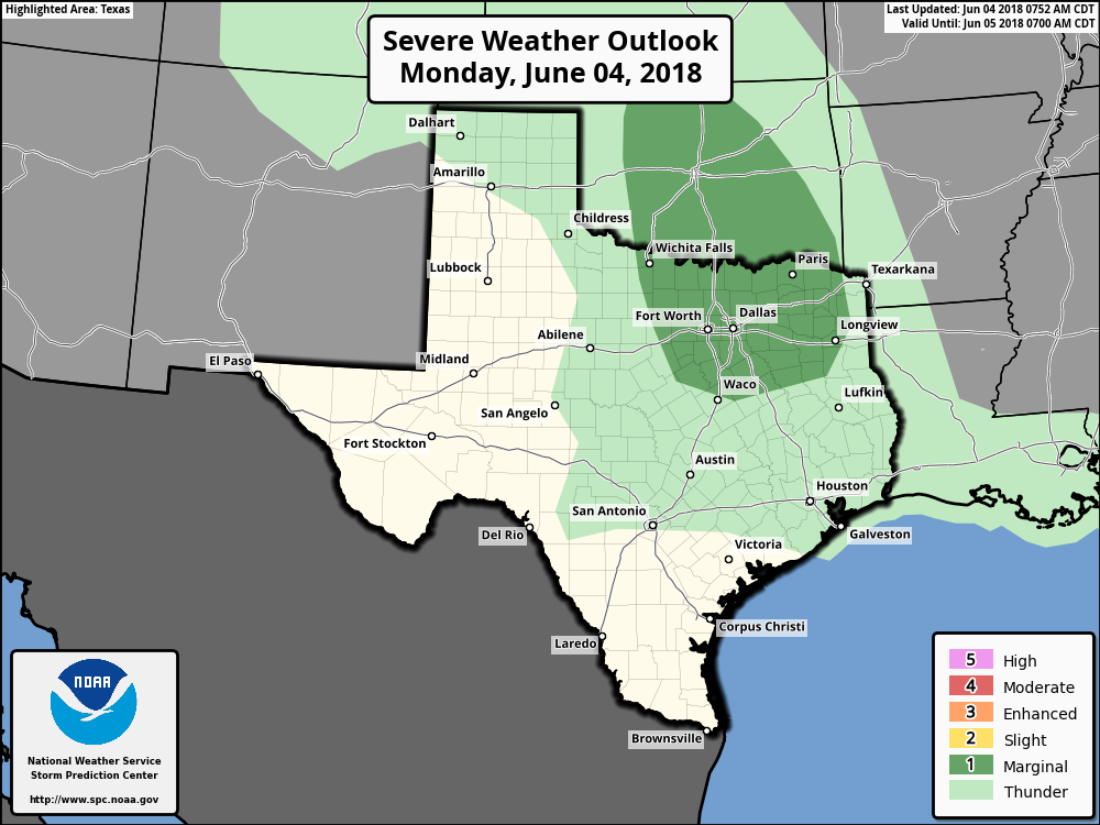 FOR THE REST OF THE WEEK - Another dry airmass will mean a quiet rest of the week for the state. We continue to forecast mostly sunny days and pleasant nights for the duration of the week. We will get into the mid 90s tomorrow followed by upper 90s for the rest of the week. THE WEEKEND - Not much change. Dry air will continue to prevail, and we will continue forecast mostly sunny days and pleasant nights. Highs will be in the upper 90s across the region which is very typical weather for early June in North Texas. See the Texas Weather Discussion Video for more details. TROPICS - The Atlantic Basin is currently quiet this morning, and will continue to remain quiet for the rest of the week.   A beautiful Sunday afternoon is taking shape in parts of North Texas. The cold air advection associated with the cold front yesterday is keeping us in the mid to upper 80s as of 1:00PM, but some of us could reach the low 90s today. The cold front also pulled some drier air down our way. You could tell from the wind shift to the north and it is less sticky outside. Dewpoints are in low to mid 60s right now. Our cold front right now is positioned near Killeen and Temple, just to the north of Austin. Highs will be in the lower 90s this afternoon, which will certainly feel much nicer than yesterday with the widespread triple-digits. Overnight lows will be 70 degrees in DFW, 67 in Canton, and even 63 in Bowie. Slightly cooler temperatures will stay to the north. MONDAY - Waking up to a beautiful morning in North Texas with temperatures in the upper 60s and low 70s while you head to work, a weakening complex of showers and thunderstorms will move in from west Texas during the day and affect North Texas during the afternoon and evening hours. Right now, there are two scenarios in the book for Monday: a) A weakening complex of showers and thunderstorms will move in from the Four Corners area and West Texas and produce widespread rainfall during the afternoon. North Texas could stay dry Tuesday morning. b) The majority of the day stays dry for North Texas. A complex of scattered showers and thunderstorms will move in from either Western/Central Oklahoma or along the Red River during the pre-dawn hours on Tuesday. Regardless of either scenario, North Texas will still be under the gun for more thunderstorms. Some of those storms could be on the strong side, producing gusty winds and hail. The SPC puts much of north Texas in the "marginal risk" (1/5) of severe thunderstorms for Monday through Tuesday morning. 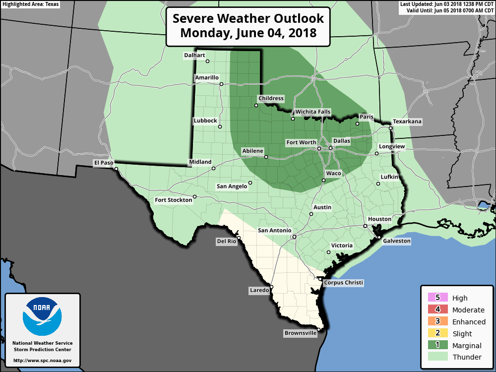 For both scenarios, Precipitable Water Values will be near 2 inches for much of the region, meaning any rain that falls will most likely be heavy rain, dumping around 1" to 1 1/2" of precipitation for the affected areas.
The airmass Tuesday morning will be very unstable, with increasing CAPE values ahead of the storm complex with sufficient moisture. Just know that any storms that do form will have the potential to produce damaging wind gusts alongside lightning and heavy rain. REST OF THE WEEK - North Texas stay dry after the storms move through Tuesday morning. We will creep back up to the mid to upper 90s with humidity values in the 40-45 percentile range as we head into the middle of June. The wind will shift back to the south as the warm front retracts to the north. TROPICS - We will keep a close eye on potential tropical mischief next weekend in the northwestern Caribbean, that could soon move into the Gulf of Mexico. RIGHT NOW - If you step outside this afternoon, it is just downright hot and sticky... Dewpoints are currently in the low to mid 70s which is pretty humid for North Texas. We are seeing sunshine in full force with temperatures mostly in the mid to upper 90s with a few triple digit readings. 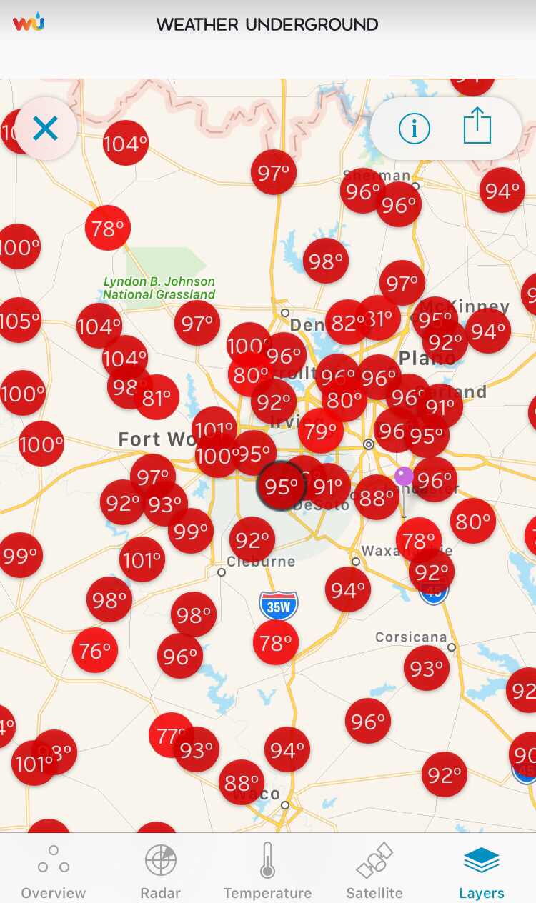 The radar right now looks quiet across the North Texas region this afternoon. 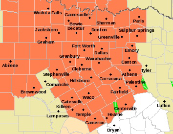 However, we are keeping a close eye on the development of strong to severe storms over the lower Mississippi Valley along a cold front. The cold front will continue to track to the southeast this afternoon and evening, and convection initiation is possible as far south as Central Texas.  We do note that the SPC has a “marginal risk” of severe storms (1/5) in place for the northeastern portions of the metro (McKinney, Garland, Sulphur Springs, Tyler, and Canton). As the storm initiation occurs as the cold front approaches from the northwest, storms should approach the area during the evening hours and could produce gusty winds and hail at times. 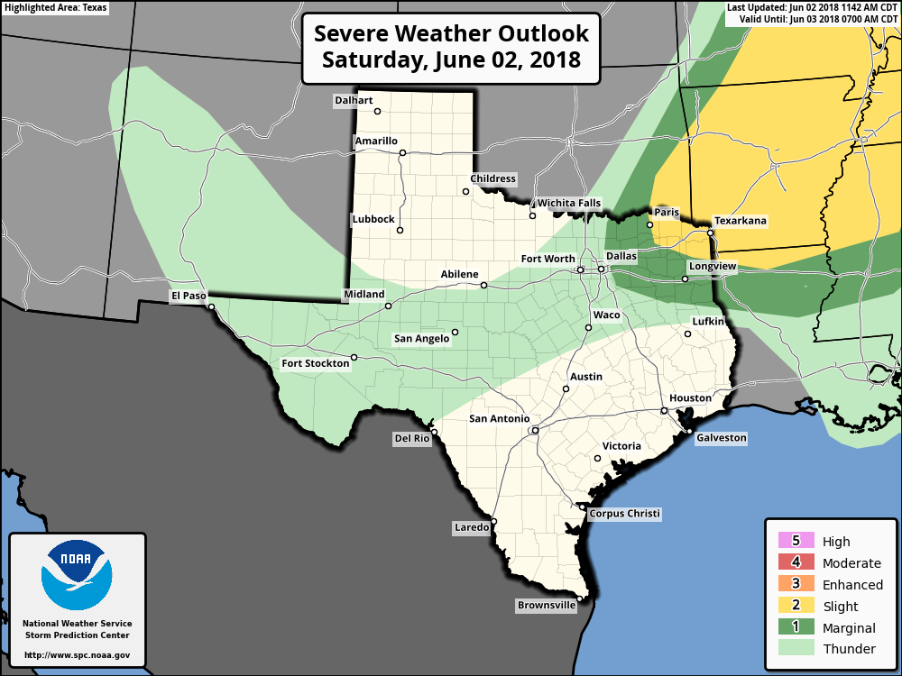 Isolated strong storms will still be possible in the metro with the best coverage in Arkansas and the Lower Mississippi Valley as indicated by our severe weather/probability of highest storm coverage map. 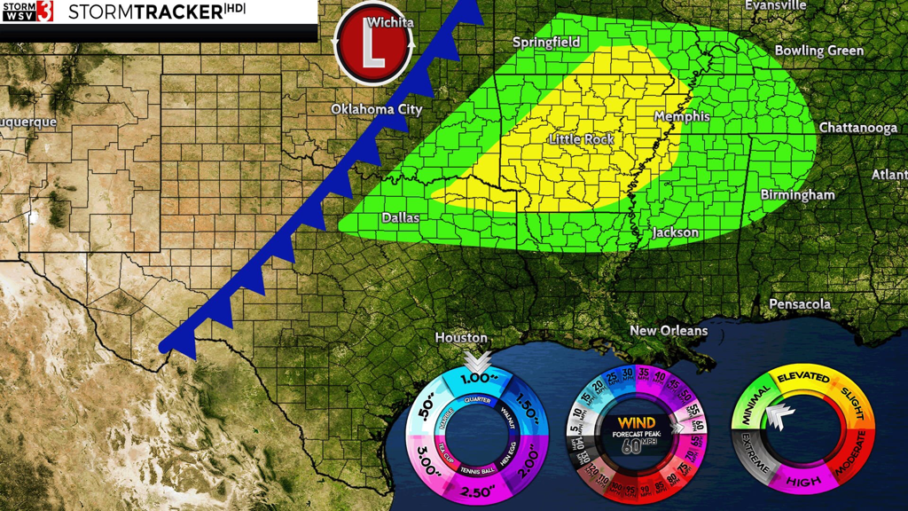 gc: Jonathan Williams FOR TOMORROW - The batch of showers and thunderstorms will weaken during the morning hours as they progress to the southeast. Most of the metro will stay dry for Sunday. We will see a wind shift to the north followed by cooler temperatures as the cold front moves through. The day tomorrow looks mostly dry with sunshine still in full force with drier air moving into the region due to lowering dewpoints and humidity levels. Highs will be in the low to mid 90s.
TODAY - Temperatures are currently in the upper 70s this morning as you wake up. Today will be no different from the past several days; hot afternoons, fair nights with highs in the upper 90s. Places to the west will likely reach the triple digits. A Heat Advisory is still in effect for Young, Jack, Stephens, and Palo Pinto counties until 7PM tomorrow. THE WEEKEND - A good portion of Saturday will be dry. We will likely see our new record temperature of 102-104, beating out the previous record of 100 degree set in 1998. Heat index values will likely be in the 105-110 range, so make sure you are exercising heat safety. A cold front approaches from the north Saturday evening, and a band of isolated showers and storms will be possible along the front. Some of the heavier storms could produce downburst winds along with a low-end hail threat. Most of the storms will start to develop at around 6:30PM, so if you have any outdoor events planned for the evening, just be aware and keep an eye on the radar and pay attention to severe thunderstorm warnings if they are required. Since these storms are more isolated in nature, the chance of one spot getting wet is around the 50/50 range. Cooler air will follow behind the front, and highs will stay in the mid 90s on Sunday with more sun than clouds. NEXT WEEK - Most of the week will stay dry, though a warm front will lift northward which could carry an isolated shower or storm or two by Monday or Tuesday. Otherwise, expect mostly dry conditions with highs in the upper 90s and lows in the upper 70s. See the Texas Weather DIscussion Video for more details. 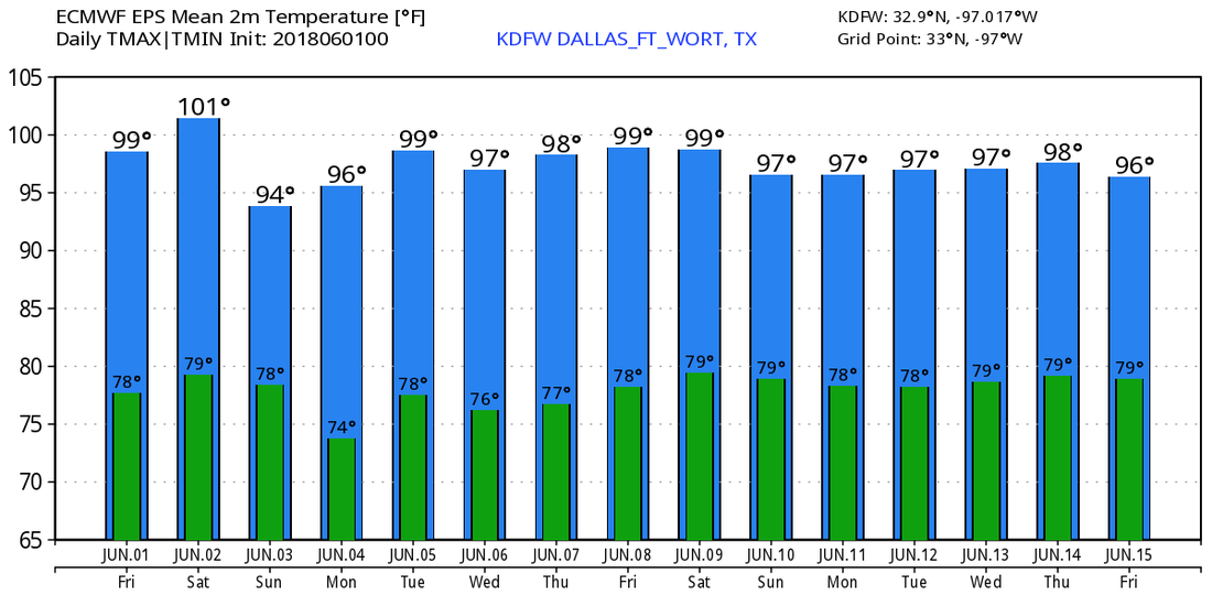 THE 2018 HURRICANE SEASON BEGINS TODAY - Today marks the first day of the 2018 Atlantic Hurricane Season, which will run until November 30. Long-term averages for the number of named storms, hurricanes and major hurricane are 12, 6, and 3, respectively.
The 2018 Tropical Cyclone names include: Alberto (already used), Beryl, Chris, Debby, Ernesto, Florence, Gordon, Helene, Issac, Joyce, Kirk, Leslie, Michael, Nadine, Oscar, Patty, Rafael, Sara, Tony, Valerie, and William. The Atlantic Basin is quiet today, and will continue to stay that way through next week. |
Archives
April 2024
Categories |
 RSS Feed