
|
NICE SPRING DAY: As forecasted, temperatures are currently in the mid 70s; DFW Airport reports 77 degrees at around 1:10 which is about two degrees below our average high for April 29th. We will continue to warm throughout the afternoon, and we should end up in the low 80s for most communities. The sky will continue to feature a mixture of sun and clouds. 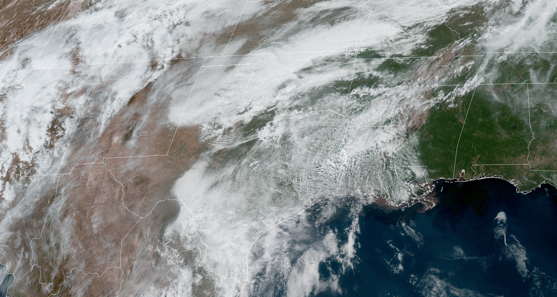 ANOTHER RAINY/STORMY WEEK AHEAD: Recently, our upper air pattern has been showcasing a digging trough in the Southwestern US followed by a ridge in the east. This pattern has kept us in a southwestern flow aloft, which is the main catalyst for rain and strong to severe storms in our state. We will once again have another of those patterns this week, starting tomorrow. First and foremost, the Storm Prediction Center updated their Day Two Outlook an hour ago. One of the notable differences is the overall risk shift to the south. The standard "slight risk" for severe storms (level 2 out of 5) has been defined for much of the North-Central Texas coverage area with the exception for the communities located south and east of a curved line from Kaufman to Goldthwaite. An "enhanced risk" for severe storms exists for Oklahoma, Kansas and some of their neighboring states, but that's not our concern as of now. 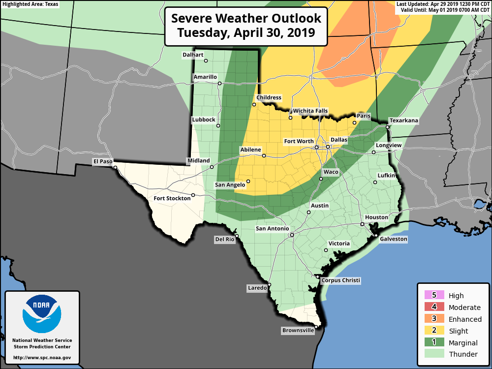 One of the concepts I want you all to understand is the term, conditional. When you hear us use this word, we use it in context along the lines of "there is a conditional threat of severe thunderstorms Tuesday afternoon and evening for all of the North Texas region.". The words in the quotes are indeed true. However, because this is a conditional threat of severe storms tomorrow, that means severe weather is not guaranteed for anyone. And if we see some development somewhere, not everyone will see severe weather at their house. This can largely be attributed to the uncertainties of the atmosphere and what it could do. To keep it simple, I won't elaborate on this, but in most cases, we don't realize our real potential of thunderstorms developing until we observe current observations. However, IF storms can break the mixed-layer and develop, atmospheric parameters are in place for discrete storms that can pose a threat for mainly large hail and gusty winds. Although, a brief tornado can not be ruled out in some spots. The best potential for large hail will actually be to the west of the DFW metroplex, out in West Texas and near the Red River. Once again, please be advised that this threat of severe weather tomorrow is highly conditional, so, it is in your best interest to keep a close eye on the radar and forecast tomorrow. However, better chances of severe thunderstorms will come Wednesday afternoon. This time around, the SPC has all of North Texas under the standard "slight risk" of severe storms.  Because there are better returns regarding a shortwave trough in West Texas, there is subsequently more confidence of showers and thunderstorms developing. This time, there is a better chance of a potential line of severe storms posing a threat of damaging winds. Like always, a brief tornado is never completely out of the question. The main window for severe thunderstorms for the North Texas area on Wednesday from 1:00 PM to 1:00 AM Thursday morning. If you we don't see severe weather on Tuesday or Wednesday, we would leave the week completely empty, as we will likely deal with a heavy rain threat during the day on Wednesday. Some flooding will become possible for the communities that receives rainfall on Tuesday. Rain amounts averaging two inches will become possible throughout the metroplex with isolated higher amounts. The surface front stalls on Wednesday, which means we will need to continue to add shower and thunderstorm chances through the Saturday morning hours. It will be nearly impossible to determine exact start/stop times due to the scattered pattern of the thunderstorms. Just know that there will be a chance for rain at least each day. Each day will feature mostly cloud cover with some sunshine. Afternoon highs during the week will vary from the low 80s to around 77 degrees on Friday. We will not fall below the low 60s for morning lows. THE WEEKEND: The stalled surface front will finally move to the southeast early Saturday morning, and that could bring some final heavy downpours as it exits the region. Once the front leaves, expect eventual clearing with more sun over time. We should be dry and mostly sunny on Sunday. Highs will be in the low 80s on both days. NEXT WEEK: Long range models continue to indicate that our wet pattern will stick through next week. At this point, it is too early to pinpoint specific rain chances, but do not expect any "summer-like" days anytime soon.  ON THIS DAY IN 2017: A total of 7 tornadoes touched down across Henderson, Hopkins, Rains and Van Zandt counties. This localized tornado outbreak was responsible for killing four people, producing an EF4 tornado near Eustace, and producing another intense tornado just to the east of Canton right after the EF4.
RADAR CHECK - As advertised, widespread rainfall is continuing to move northeast. This rain stretches all the way down to Southwest Texas. Today will feature something that we will always take; a good, long day of soaking rains across the region. A few thunderclaps is possible in the mix, and the threat for severe weather this afternoon and evening is extremely low, but not zero.  The main threat we will have to deal with is heavy rainfall. Although the showers and storms will be moving at a good speed, we could still see flooding in the North Central Texas region today as more rain will move over the areas that have already received copious amounts of rainfall yesterday. We will not warm much at all today, as temperatures should stay in the 60° range. As storms exit the region tonight, we could still see some lingering showers and storms during the morning hours tomorrow, but most of the showers will be gone by the afternoon, and we will mention slowly decreasing clouds in the afternoon and evening. Highs will be in the mid 70s. FRIDAY AND THE WEEKEND: We change seasons once again over the next few days. Each day will feature a mostly sunny skies with highs in the low to mid 80s throughout the weekend. Winds may increase progressively, but it should be a very nice weekend. NEXT WEEK: An active week of potentially stormy weather is possible across the south-central US. More details will become available as soon as they get ironed out, but expect seasonably warm temperatures with a mix of sun and clouds next week. 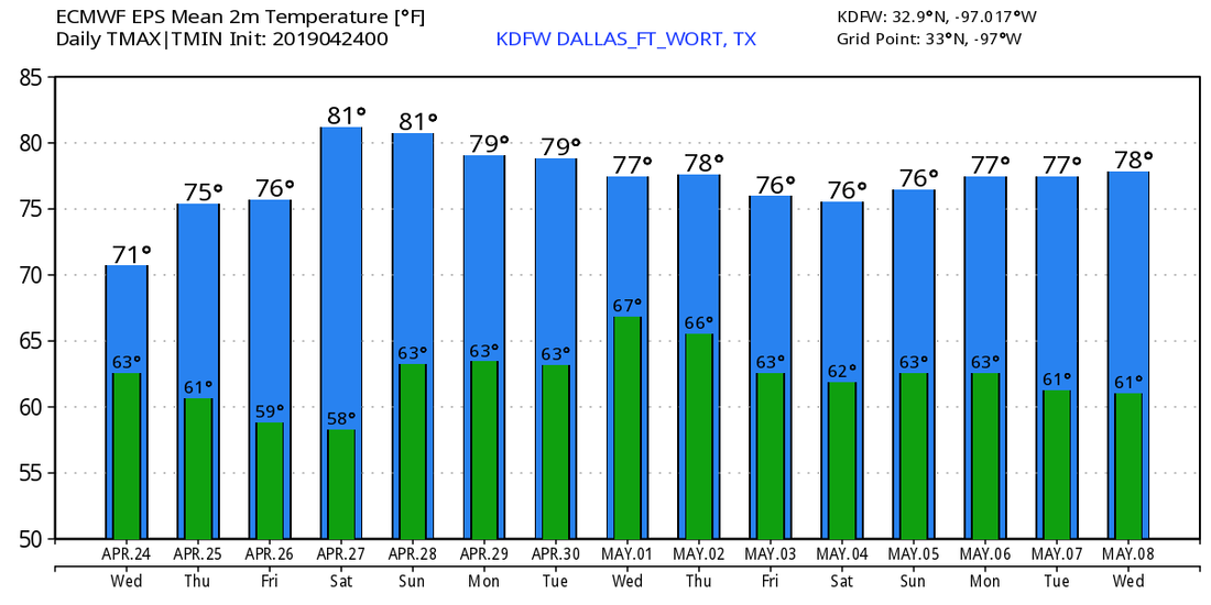 MOSTLY DREARY TODAY: Temperatures are holding in the mid 60s this morning.... with a mostly cloudy sky, we will be mild by the afternoon with highs in the upper 70s to low 80s during the peak of the day (the average high for DFW on April 22 is 78°). WET WEEK AHEAD: A broad surface low moving to the east with time will bring the chance of a few severe storms for South-Central Texas and the chance of some good, soaking rainfall for the Northern portion of Texas this week. Tuesday will actually start out dry and mild, but rain, and especially storm chances, will increase during the afternoon and evening hours, especially for our drought-stricken southwestern counties of our region. The SPC has defined the standard "slight risk" (level 2 of 5) of severe storms for areas to the south of the greater DFW metroplex. A "marginal risk" (level 1 of 5) of severe storms surrounds the rest of the metroplex. 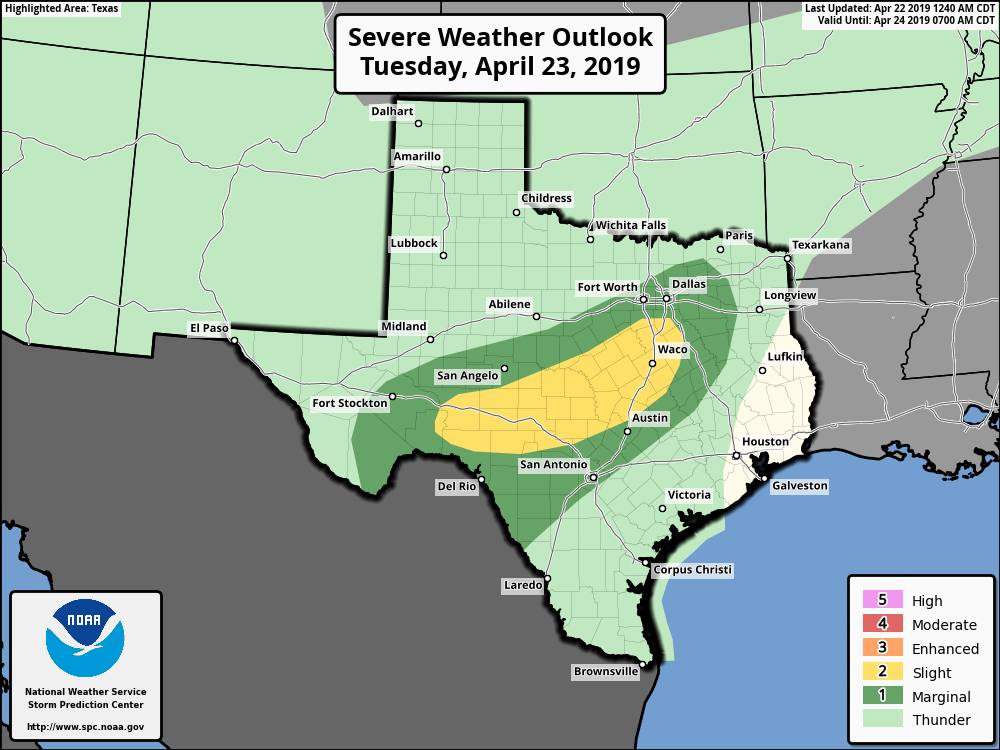 All though this should just be a rain and thunderstorm event for the next few days, we will have to watch for the potential of some storms turning supercellular Tuesday afternoon and evening, mainly producing a threat of large hail and gusty winds. But one thing you must understand though, this system is more of a rain producer rather than a severe weather producer. As the surface low continues to maintain its strength and progresses further to the southeast, the best chance of good rainfall will move east along with it, and we should see some good, soaking rainfall by Wednesday. Rainfall amounts of 1 to 2 inches with locally higher amounts of 3 inches is possible. Localized flooding may become a concern overtime, but probably not enough for a Flash Flood Watch issuance. We will continue to mention the chance of scattered showers and storms during the morning hours, but those chances will dwindle during the afternoon as the storm system slowly exits the state. It will still be breezy, but we will finally begin to mention breaks in the clouds at times as cooler, drier air enters the state. Temperatures will be in the 70° range all week. FRIDAY AND THE WEEKEND: After showers and thunderstorms exist the state, drier air will follow. Each day will feature a mostly sunny sky with seasonably warm temperatures. Highs will be in the 80s. NEXT WEEK: The early part of next week is shaping up to be mostly sunny with seasonal temperatures.  ON THIS DAY IN 2010: An intense EF3 tornado hit a small community of Cee Vee in the Panhandle of Texas. This was a large wedge tornado that tracked for 12 miles, destroying a house and multiple farm buildings. Trees were uprooted, farming equipment was overturned, and even a heavy steel tank was knocked to its side. Was preliminarily an EF-1, but was upgraded to an EF-3 in a post-analysis. This was part of a four-day outbreak of tornadoes from the 22 through the 25th.
ANOTHER COOL MORNING: In advance of a storm system, temperatures are currently in the mid 60s this early morning, which is actually not bad for mid April. We actually hang on to clouds this morning, but we will eventually see some clearing as we head into the early afternoon hours. This is typically the case for a severe weather day here in Texas. TAKE A DEEP BREATH: Before I say anything else, keep in mind that we are basically in the peak of severe weather season, meaning, severe weather threats like this will be maximized around this time of the year. There is no need to be scared, however, you need to make sure you are prepared for this evening by making sure you have a way of receiving warnings, and to make sure you and your family or loved ones have a safe place in your home so you can quickly jump in in the event of a significant hailstorm or tornado warning. Not everyone will see severe weather today, and there is definitely a chance that we will see absolutely nothing at all. However, everyone should be prepared today. SEVERE WEATHER EVENT THIS EVENING THROUGH THURSDAY MORNING: A potent storm system located over West Texas will bring the potential for severe thunderstorms over much of North and Central Texas this afternoon through the overnight hours. We have found out over the years that North Texas is a famous hail corridor, and we tend to get more reports of hail and damage from hail than anywhere else in the country. We will be dealing with that threat today. We typically have these great threats of significant hail only once, maybe twice a year at best, so this is something that should not be taken lightly. Forecast surface based CAPE values (instability) are expected to soar into the 3,000/4,000 j/kg range, creating a "powder keg" situation by the late afternoon hours. The Storm Prediction Center maintains the "enhanced risk" (3/5) of severe storms over all of the North-Central Texas region through Central Texas and some of the adjacent states. 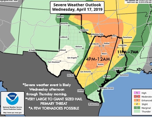 Do not get caught up in looking at these risk maps and lines, colors, and vocabulary. This is just simply a guideline, meaning, like we saw on Saturday, storms do not read these maps and certainly do not know where the lines are located. Just know that all of North and Central Texas has a risk of severe weather this afternoon into the overnight hours. TIMING/THREATS: There is the potential for multiple wavves of storms from around 4:00 PM through 12:00 AM Thursday morning. The primary threat with the initial batch of supercells will come from very large to giant sized hail. These usually peak in the size of baseballs, softballs, and grapefruit in the most extreme cases. We could be dealing with that today. Also, the tornado potential is low, but not zero. We will have to especially watch this as the sun goes down as mid level winds become stronger after dark. The damaging wind risk will increase as storms congeal into a line over time. RAIN: Amounts of around 1- 1 1/2 inch are likely. Some flooding issues are possible with cities that receive multiple severe storms. CALL TO ACTION: Be sure you have a way of getting severe weather warnings; a NOAA weather radio is the base standard, and having a good smart phone app is the next level. Make sure you can identify the safe place in your home, and everyone knows where it is. In that safe place, have hard sole shoes and a portable airhorn in case you need help. COLDER AIR: Thursday will be breezy and much cooler with clearing taking place; some lingering showers is possible during the morning hours. Temperatures will hold in the cool 70s much of the day. Then, we drop into the even cooler low 50s by daybreak on Friday. Friday afternoon will be in the low to mid 70s. THE WEEKEND: Expect a much calmer weekend with mostly sunny skies and windy conditions in place. Each day will feature brisk winds, mostly sunny skies with highs in the low 80s. NEXT WEEK: Medium range model data suggests we might see some rain during early next week, but for now, it doesn't look like a setup for severe thunderstorms. See the Texas Weather Discussion Video for more details. 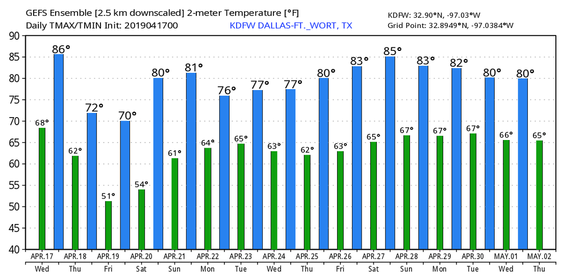 BIG COOL DOWN: As advertised, temperatures are currently in the low to mid 60s as I do this update, and we should not warm much today; we will only reach the mid 70s this afternoon with a mix of sun and clouds. It will continue to be very breezy with a northwest wind of 10-20 mph on average. The weather won't change much tomorrow; dry, warm, a mix of sun and clouds. The high will be in the low to mid 70s. Winds will shift to the east with average speeds of 5-15 mph. ACROSS THE NATION: Heavy snow with extreme winds will overspread parts of Nebraska, Minnesota, and Wisconsin today. This will create blizzard conditions for the affected areas, severely interrupting travel, becoming impossible at peak. SEVERE WEATHER LIKELY THIS WEEKEND: A potent storm system positioned over Central Texas will bring another weekend of unsettled weather across Texas. Rain will be possible with mostly cloudy skies on Saturday. Keep in mind that the SPC has outlined an "enhanced risk" of severe storms (3/5) for parts of extreme Southeast Texas, with the standard "slight risk" of severe storms extending all the way towards the metroplex. 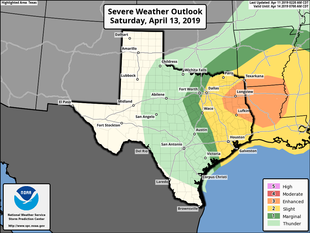 But, for Friday, a "marginal risk" (1/5) of severe storms is defined for much of the North Texas area and a portion of West Texas. 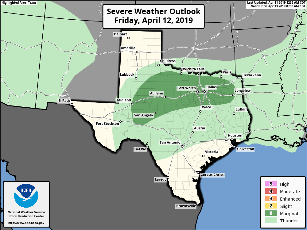 TIMING: Storms could begin as early as the early morning hours on Saturday for parts of NTX. As we continue throughout the day, we will see showers and thunderstorms increase statewide and spread to the north with time. It is still too early to pinpoint exact timing, but it looks like most of the severe thunderstorms across Texas will come from around 12:00 PM Saturday afternoon to 12:00 AM Sunday morning. The rain and severe weather threat will gradually shift to the east with time. THREATS: For the early morning round, it looks like hailstones will most likely be the prominent threat for the most intense storms. The SPC has North Texas in a risk of severe weather for all of Saturday, and it continues to look like all modes of severe weather will be possible. Large hail, damaging winds, and tornadoes (some strong) is not out of the question. Keep in mind that this event is still about 2-3 days out, and there is still lots of uncertainty regarding the small scale features, which is difficult regarding forecasting timing, magnitude, and placement of the event. Definitely expect changes and refinements as we get closer to the weekend. Now is a good time to review your severe weather plan. Make sure you have a way of hearing warning (NOAA Weather Radio), and a good plan in place to get into a safe place in the event of a tornado warning. We should start to see some clearing by Sunday, and we should be mostly sunny with afternoon highs in the mid 60s by that point. NEXT WEEK: The latter half of week looks pleasant with mostly sunny skies and highs in the 70s, another system could bring some storms to the state on Tuesday and Wednesday, but it is best to get through this weekend's system before we can reel in onto next weeks.  This will be the last blog update from me this week... I will be traveling to Florida for a band vacation early Friday morning and will be there through Monday, so no blog update from me on Monday, either. Logan Shipley will cover the blogs regarding the severe weather threat and the weekend. Expect the next guaranteed Texas Weather Discussion Video from me, posted here by 7:00 AM Tuesday...
WARM START: Temperatures are currently in the upper 60s to low 70s later this morning, which is very unusual for mid April because usually we would be in the mid 50s at this point. As what always happens most of the time, warm starts will usually lead to relatively hot afternoons, and temperatures will be in the low 90s with a mostly sunny sky. A tight low pressure gradient over Denver, Colorado will make for a very windy day across the Plains, and a Wind Advisory is in effect for much of North Texas today for winds of around 20-25 mph with gusts of up to 40-45 mph. Higher sustained winds will remain to the west, where a combination of high winds, low humidity, and high temperatures will lead to a potentially dangerous fire weather day across West Texas and Central and eastern New Mexico. 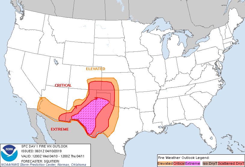 Then, on Thursday, we will mention highs in the low 70s and upper 60s on Friday with a cold front drifting down into the state. Both days will feature mostly sunny skies. Rain amounts (if any) should remain very light. STORMY WEEKEND AHEAD: A dynamic storm system emerges from the southwest and should bring widespread showers and thunderstorms to the state throughout the day Saturday. Global models suggests that the main window for strong to severe storms for East Texas will come from about 12:00 PM to 12:00 AM early Sunday morning. This is guaranteed to change as we get closer to the weekend. THe SPC has already defined an "enhanced risk" of severe storms for small Ark-La-Miss-TX corridor, with the standard risk of severe weather surrounding that. 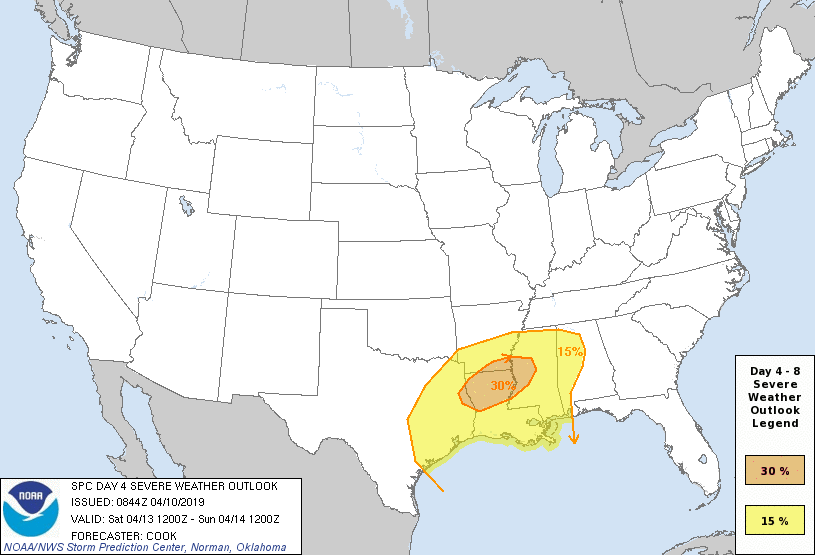 It looks like the main threat of severe weather will come from mostly damaging winds, but large hail, and tornadoes look to be a possibility as well. Be sure you have a severe weather plan in place. Have a NOAA Weather Radio, and a call to action to put your people in a safe place in the event of extreme hail, wind, or a tornado warning. NEXT WEEK: The first part of next week will be dry and cooler than today... Highs will be in the upper 70s with early morning lows in the 50s... See the Texas Weather Discussion Video for more details. 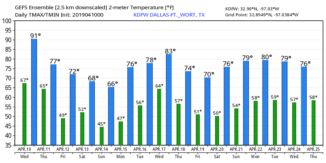 COMFORTABLE MORNING: After a long, dreary weekend of an unsettled weather pattern, the surface low is finally more in the Ark-La-Tex region, and temperatures are currently in the upper 50s to low 60s this morning. With a full supply of sunshine, we should experience mostly sunny skies with a high in the low 80s this afternoon. Expect even sunnier conditions on Tuesday with sunshine in full force. Most of us will start to feel pretty warm with highs approaching the mid to upper 80s by the afternoon. MID-WEEK: We warm up even more with an abundance of sunshine, and we could see our first 90° day of the year this Wednesday. With a tight pressure gradient with a surface low positioned in Colorado, we will experience gusty winds with a southerly wind of 15-30 mph with gusts of up to 45 mph. Keep in mind that the average high for April 10th is 75° in DFW. We will be well above that... A cold front moves through Thursday morning, and we will only reach the low 70s as a result. Winds will shift to the northwest, but we will still stay breezy. And, Friday should still be mostly dry and relatively breezy with highs in the mid to upper 60s. Both days will feature a mostly sunny sky. THE WEEKEND: Another influx of moisture from the Gulf moves through most of Texas, and we should see another round of scattered showers and thunderstorms on Saturday. It is unknown if we see more severe weather, but for now, this looks to be more of a rain event for North and Central Texas. Then, we begin to clear during the afternoon on Sunday with some sun at times. Highs will be in the low 60s on Saturday, followed by middle 60s by Sunday. NEXT WEEK: Monday stays fairly dry, but another surface front could bring storms through parts of North Texas on Tuesday. At this point, it is way too early to forecast any potential for severe weather. Most of next week stays in the 70s with mostly sunny skies. See the Texas Weather Discussion Video for more details. 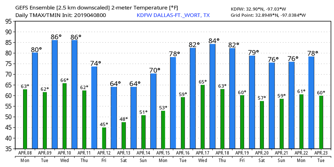 GREY SKY: We are forecasting mostly cloudy skies across North texas today with highs in the upper 60s. But we will see a few showers this evening through Thursday morning as a result of moisture increasing. We will forecast a good supply of sunshine tomorrow. The SPC has defined a risk of severe weather for areas to the north of the Red River, mainly. Some thunderstorms are possible at times, but no organized severe weather is expected down here. Rain will end by the evening hours tomorrow. We will forecast partly to mostly sunny conditions for Thursday and Friday with highs in the low 80s on both days. THE WEEKEND: It looks like we will forecast a high in the 76-80 degree range for Saturday and Sunday. On Saturday, we will forecast a mix of sun and clouds with potential for scattered showers and thunderstorms throughout the day. It will not be an all day, continuous rain, however, but there could be some minor street flooding where rain does fall. Some of the rain persists through Sunday afternoon, which will get affected by the daytime heating process. With a shortwave trough approaching, some of the storms could be on the strong side. We will have to keep tabs on severe weather parameters as we get closer to Sunday. NEXT WEEK: At this point, much of next week looks dry with mostly sunny skies and highs in the 80s. 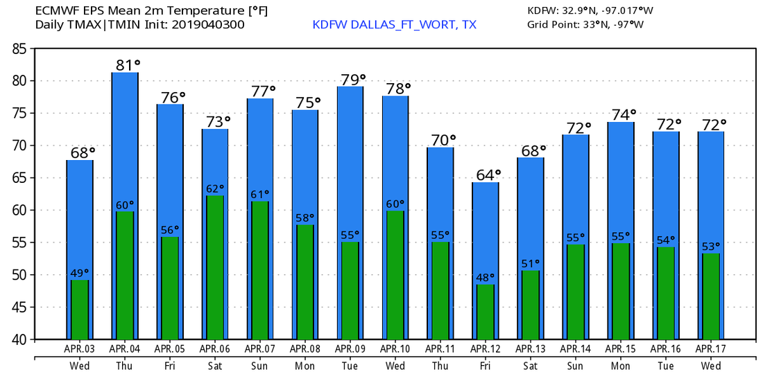 ON THIS DAY IN 2012: A localized tornado outbreak took place during the late morning/afternoon hours of April 3rd. 2 EF2 tornadoes were confirmed in Arlington and Lancaster/South Dallas, respectively, and an EF3 in Forney. In total there were 22 tornadoes confirmed with $400 million dollars in damage as a result of the outbreak. Thankfully, there were no fatalities. The most photographed tornado of the outbreak was the Lancaster EF2 tornado, which stayed on the ground for almost thirty minutes. Where were you while this happened?
LATE SEASON FROST/FREEZE: Temperatures are mostly in the middle 40s across North Texas this morning. Some places are showing mid 30 readings or some readings just below or at the freezing mark. There is a pretty good chance this morning will for certain be the last freeze of the season (no quoting me on that) for most of Texas as we take on more of a spring pattern in coming weeks. Today will be mostly sunny and comfortable with a high in the low 70s for most communities. A wave feature in the Gulf of Mexico will bring clouds to the state tonight, but we shouldn't have to worry about rain for today. MID-WEEK: Tomorrow will be mostly cloudy with highs in the low 70s, then we rize to the low 80s on Thursday with mostly cloudy skies. During the day, the weather stays dry and mild with increasing sunshine, but we will introduce the chance of morning showers and thunderstorms with the wave from the Gulf of Mexico. It will not be an all day rain, and it should end before the afternoon. SPC has defined a risk of severe storms for areas to the north of us (Oklahoma), but for now, we are not expecting any severe weather in North Texas Wednesday morning. FRIDAY AND THE WEEKEND: Friday should be mostly dry and sunny with temperatures in the upper 70s by the afternoon. Then, over the weekend, a moist airmass will be in place over much of Texas, meaning, some risk of showers and thunderstorms exists Saturday and Sunday morning. This is by no means a 'wash-out', but scattered thunderstorms are certainly possible throughout the day at times. Some localized flooding is possible with the communities that experience heavy downpours over time. The sun should peak out after Sunday morning, and temperatures will stay in the upper 70s this weekend. NEXT WEEK: Most of the week will be dry and tranquil with mostly sunny skies. Look for 80 degree warm in most afternoons. See the Texas Weather Discussion Video for more details. 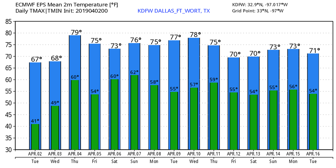 ON THIS DAY IN 1957: An F3 tornado tore through the heart of Dallas, killing ten people and injuring 216 individuals. Total damage costs estimated to be around four million dollars. This tornado is one of the most photographed and studied in history.  |
Archives
April 2024
Categories |
 RSS Feed