
|
MOSTLY DREARY TODAY: Temperatures are holding in the mid 60s this morning.... with a mostly cloudy sky, we will be mild by the afternoon with highs in the upper 70s to low 80s during the peak of the day (the average high for DFW on April 22 is 78°). WET WEEK AHEAD: A broad surface low moving to the east with time will bring the chance of a few severe storms for South-Central Texas and the chance of some good, soaking rainfall for the Northern portion of Texas this week. Tuesday will actually start out dry and mild, but rain, and especially storm chances, will increase during the afternoon and evening hours, especially for our drought-stricken southwestern counties of our region. The SPC has defined the standard "slight risk" (level 2 of 5) of severe storms for areas to the south of the greater DFW metroplex. A "marginal risk" (level 1 of 5) of severe storms surrounds the rest of the metroplex. 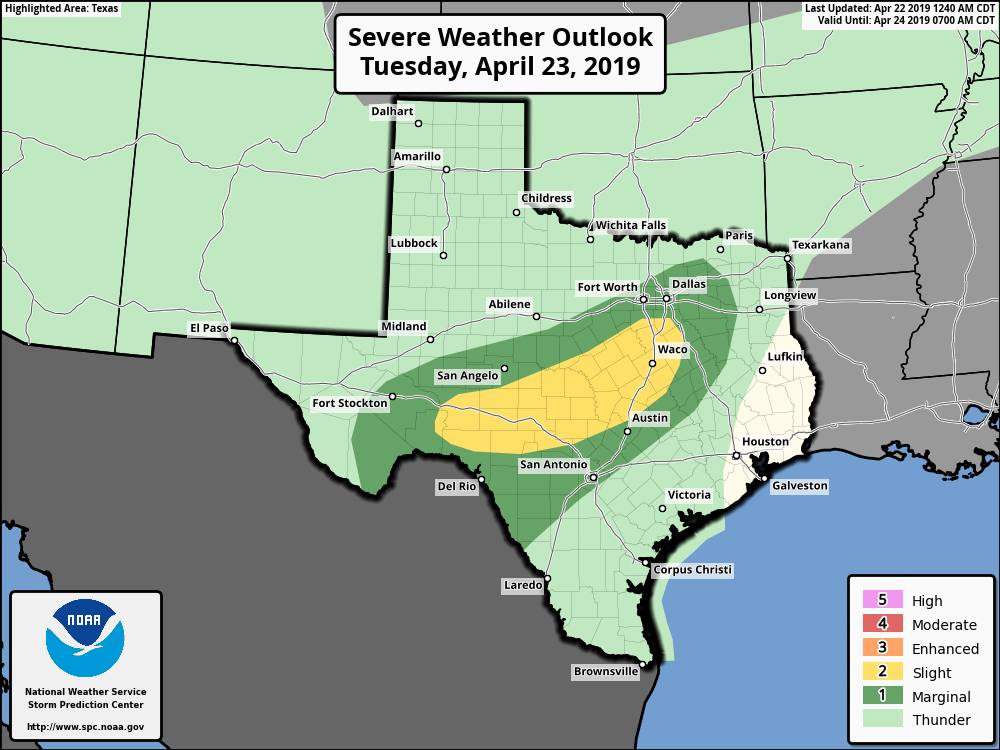 All though this should just be a rain and thunderstorm event for the next few days, we will have to watch for the potential of some storms turning supercellular Tuesday afternoon and evening, mainly producing a threat of large hail and gusty winds. But one thing you must understand though, this system is more of a rain producer rather than a severe weather producer. As the surface low continues to maintain its strength and progresses further to the southeast, the best chance of good rainfall will move east along with it, and we should see some good, soaking rainfall by Wednesday. Rainfall amounts of 1 to 2 inches with locally higher amounts of 3 inches is possible. Localized flooding may become a concern overtime, but probably not enough for a Flash Flood Watch issuance. We will continue to mention the chance of scattered showers and storms during the morning hours, but those chances will dwindle during the afternoon as the storm system slowly exits the state. It will still be breezy, but we will finally begin to mention breaks in the clouds at times as cooler, drier air enters the state. Temperatures will be in the 70° range all week. FRIDAY AND THE WEEKEND: After showers and thunderstorms exist the state, drier air will follow. Each day will feature a mostly sunny sky with seasonably warm temperatures. Highs will be in the 80s. NEXT WEEK: The early part of next week is shaping up to be mostly sunny with seasonal temperatures. 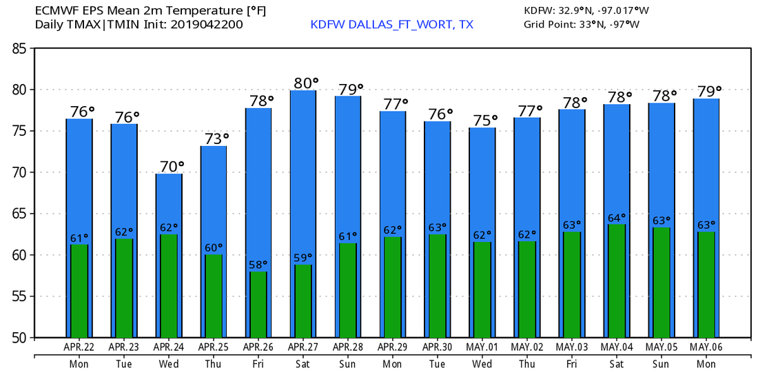 ON THIS DAY IN 2010: An intense EF3 tornado hit a small community of Cee Vee in the Panhandle of Texas. This was a large wedge tornado that tracked for 12 miles, destroying a house and multiple farm buildings. Trees were uprooted, farming equipment was overturned, and even a heavy steel tank was knocked to its side. Was preliminarily an EF-1, but was upgraded to an EF-3 in a post-analysis. This was part of a four-day outbreak of tornadoes from the 22 through the 25th.
|
Archives
March 2023
Categories |
 RSS Feed
