
|
NICE WARM-UP THIS AFTERNOON: Temperatures are mostly in the low 40s across the region this morning, but we warm into the mid 50s this afternoon as we continue a warming trend. The air will remain a little moist and the sky will be mostly cloudy through the weekend. Some drizzle and showers at times are possible throughout the day. Tomorrow will feature a high in the mid 60s with a mostly cloudy sky. THE WEEKEND: Despite cloud cover, Saturday will be a fairly dry day with highs in the mid 60s for most communities. Moisture starts to increase, and a few showers at times will become possible during the afternoon. Moisture will increase even more on Sunday with showers still possible, but nothing widespread or major. Sunday's high will be in the low 70s. NEXT WEEK: The next week is looking relatively dry. Most days will be filled with a mix of sun and clouds with afternoon highs in the mid 70s for the early part of next week. Another cold front moves to the south by Wednesday morning, which will keep us in the low 50s for Wednesday with a few showers followed by mostly cloudy skies during the afternoon. We turn dry with partly cloudy skies and chilly temperatures for the latter half of the week. See the Texas Weather Discussion Video for more details. 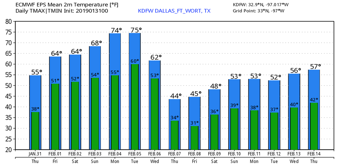 YET ANOTHER COLD MORNING - In wake of yet another arctic front that came through the region yesterday evening, temperatures are currently in the mid to upper 20s to the low 30s across North Texas. It will be another chilly day today with temperatures in the upper 40s with a mostly sunny sky. The good news is, the wind will not be as strong today, but when we do have gusts, you can expect wind chills to be down in the upper 20s. WEDNESDAY THROUGH FRIDAY - We start the gradual warm up through the weekend. Most of these days will feature a mix of sun and clouds. Highs will be in the mid to upper 50s Wednesday and Thursday, followed by low 60s on Friday. Friday will be mostly cloudy with a few seasonal showers possible by the afternoon. THE WEEKEND - We turn very mild for the weekend, but will feel nice after this cold today. Most of the weekend will feature more clouds than sun with highs in the 65-70° range during the afternoon. NEXT WEEK - We stay pretty mild for the early half of next week. A cold front comes through Tuesday evening, which will drop temperatures to the 50s by the latter half of this week. Each day will feature a mix of sun and clouds with only light precipitation expected. See the Texas Weather Discussion Video for more details. 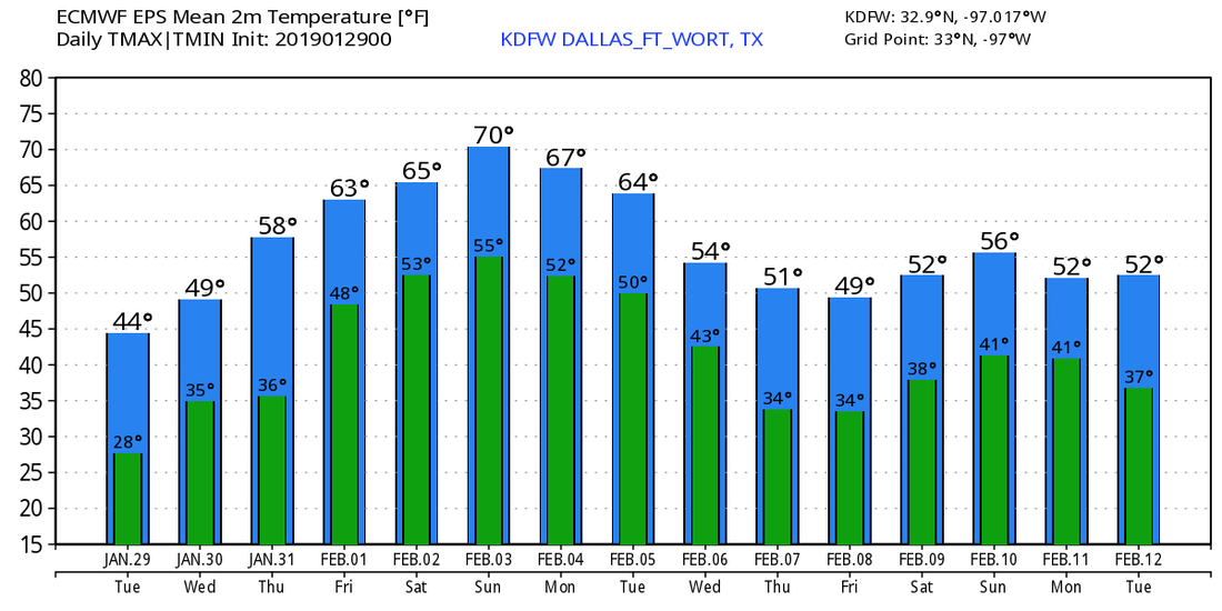 CHILL IN THE AIR - As forecast, colder air has moved into North Texas this morning (again), and there was a chance that some places saw a flurry or two overnight. Temperatures are mostly in the 27-35° range over the region. Look for more sun than clouds today with a high in the upper 40s. THE WEEKEND - We turn very mild for the weekend with mostly sunny skies. Highs will be in the mid to upper 50s on Saturday, followed by low 60s by Sunday. The best chance of rain on Saturday will remain to the south of North Texas. NEXT WEEK - Monday looks mostly dry and mild with mid 60s on the board, then we turn sharply cold again with another arctic front moving through the region overnight into Tuesday. Temperatures fall into the low 40s on Tuesday, and we should still be dry since these type of systems typically have very limited moisture. A warming trend begins during the latter half of this week... See the Texas Weather Discussion Video for more details. 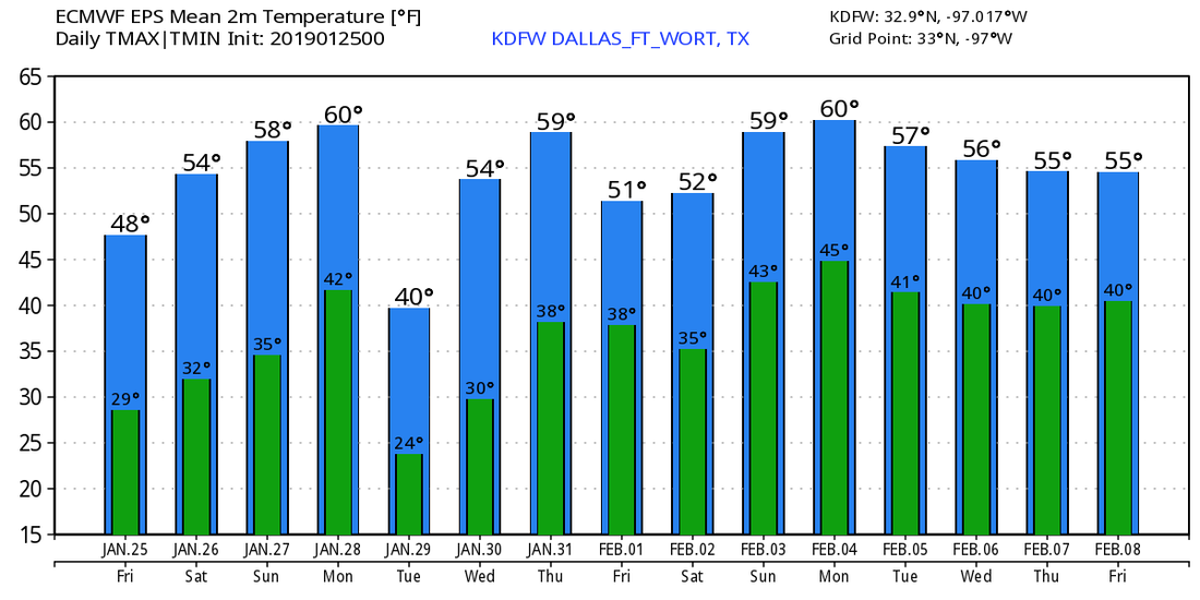 TODAY - We expect a good warm-up from yesterday with temperatures in the middle 50s in the afternoon. Be sure to still bundle up this morning though, as temperatures are still in the low 30s for much of the region. A wind shift to the northeast is expected, and winds will be a tad calmer today. A few mesoscale models have been suggesting the *potential* for light snow mixed with some light rain behind the cold front that will come through this evening. Similar to what we saw during the pre-dawn hours yesterday, no accumulation or impacts are expected if this were to come into fruition. In wake of the cold front, we start Friday off with a hard freeze with temperatures in the mid 20s in the morning. Highs will be in the upper 40s later today with a mostly sunny sky. THE WEEKEND - Not much change. Current thinking is the weekend will also stay dry with highs in the mid 50 - low 60 degree range for the weekend with mostly sunny skies. Winds would increase to 10-15 mph range again. Any chance of showers on Saturday will remain south of DFW. NEXT WEEK - Our next chance of some light wintery weather comes Monday night into Tuesday with another arctic front. Winds will also increase on Monday and Tuesday. Highs will be in the low 60s on Monday, followed by the upper 30s the very next day. We start to warm up on Wednesday, then we stay consistent during the latter half of the week with highs mostly in the mid 50s. 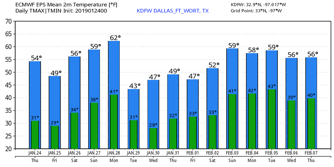 BONE-CHILLING MORNING - In wake of a cold front yesterday afternoon, we received a few reports of light snow/ice pellets over parts of North Texas overnight as an associated storm system moved through the region. Now, temperatures in the mid to upper 20s early this morning, with a few higher readings off to the south. Due to a strong northwest wind of 15mph, it feels like we are in the upper teens this morning. Winds will continue to stay strong throughout the day with mostly sunny skies, and highs will be in the upper 40s this afternoon. REST OF THE WEEK - Thursday and Friday will feature mostly sunny skies with afternoon highs in the low to mid 50s. Winds will shift to the northeast by Thursday afternoon, and winds will begin to eventually subside by Friday. Tomorrow morning will have temperatures in the upper 20s, and subsequently in the low 30s Friday. THE WEEKEND - Another small cold front moves through the region on Saturday, and we will remain mostly cloudy for much of the day. A few showers are possible again during the afternoon, and I wouldn't be surprised if we end up seeing a few sleet pellets again if temperatures can reach down into the 30s again. We turn sunny on Sunday with highs in the mid 50s. Saturday's high will be in the upper 40s. NEXT WEEK - We remain mostly sunny throughout the entire week. Another cold front moves through in dry fashion on Tuesday, dropping highs in the 40-50 degree range for much of the week. Winds will increase by Tuesday. See the Texas Weather Discussion Video for more details. 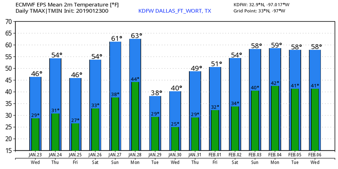 MILD MORNING - We start the morning with temperatures in the mid to upper 50s across the North Texas region, which is actually around our average high temperature of 57° for January 22. Today will be mostly cloudy and windy in advance of another cold front, and a few showers will become possible beginning in the afternoon. The air will be very stable, so there is no threat of severe storms, and probably no thunder. Rain amounts will stay under a quarter of an inch with heavier totals to the east. Today will be mild with highs in the mid 60s. Colder air begins to flow into the region overnight, and there is a chance that a few slow flurries could develop early Wednesday morning, but for now we expect no accumulations or impact. Tomorrow will feature a mostly sunny sky with highs in the upper 40s with a 15-20 mph northwest wind. Then, we warm ten degrees by Thursday with another mostly sunny sky. We will continue to see winds of 10-20 mph, but we will see winds shifting to the north by the afternoon. Then Friday will be partly to mostly sunny with highs in the upper 40s with a north wind of 15 mph. THE WEEKEND - Not much change for the weekend. Saturday will be mostly cloudy with highs in the upper 40s to low 50s. I wouldn't be surprised if we see a few showers squeeze out of the clouds. We fully transition to sunshine by Sunday with highs in the low 50s. NEXT WEEK - Monday will be dry and sunny, then clouds start to roll in for Tuesday and Wednesday, before transitioning back to sun for the last day of January. It looks like we won't get out of the 40s with the clouds in place Tuesday and Wednesday. We mention that there is no evidence of any significant snow or ice event for North Texas over the next 10 days, although a few flurries are possible very early tomorrow morning. See the Texas Weather Discussion for more details. 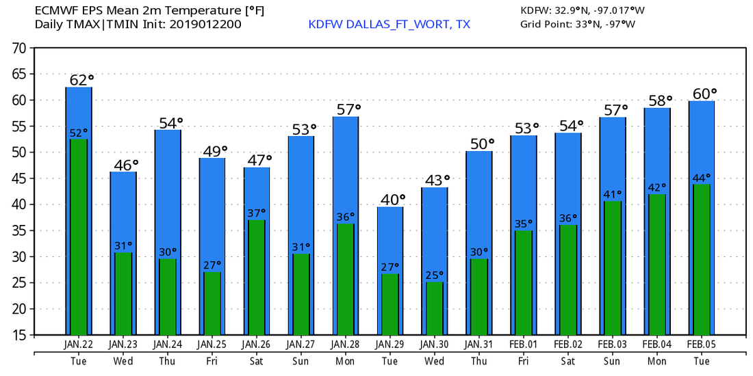 *no Texas Weather Discussion Video this morning* CHILLY MORNING - Temperatures are mostly in the mid 40s across the great region right now, which is still a few degrees cooler than yesterday. Clouds and fog will affect the morning commute, but we could see some sun peak during the day. A couple of showers will be possible mainly during the evening, and the best chance of one spot getting wet is in the 40-50 percent bracket. Some rain may persist overnight. Today's high will be at or close to 70°. THE WEEKEND - After starting the day basically at the freezing mark, we turn sharply cold starting Saturday with the coldest air of the season thus far. If we still have some moisture by the morning hours, I wouldn't be surprised if we see some flurries by early morning. The arctic cold front Friday evening will send temperatures plummeting into the mid 30s by mid-morning. But we will see a slight recovery into the very low 40s by the afternoon. We should clear into sun by the afternoon. It will also be windy with a northwest wind of 25mph, with gusts to 30mph likely. However, wind chills will be in the 20s, so it will definitely feel much colder. After a hard freeze overnight, Sunday should be mostly sunny with highs in the mid 40s. Although the wind will not be as strong, wind chills in the 20s are still very well possible. NEXT WEEK - At this point, next week features mostly a mix of sun and clouds with highs mostly in the mid 40s - mid 50s range by the afternoon. 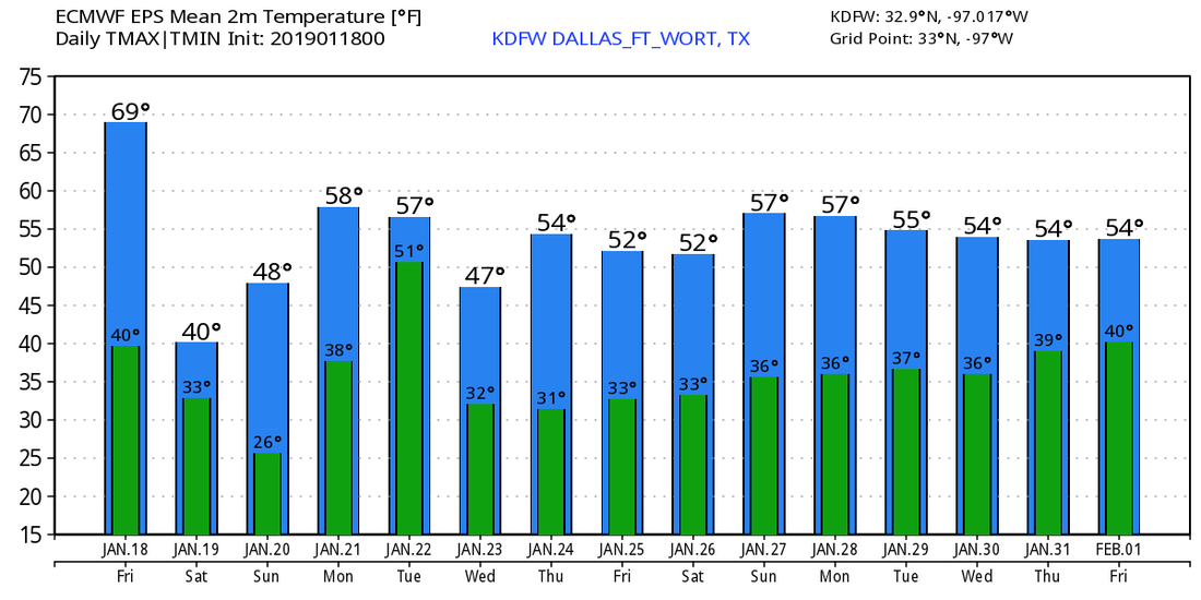 A LITTLE WARMER - Temperatures are mostly in the mid 40s with some of the readings at the 50° mark. The good news is, we will not stay like this all day, as we will warm to the low 60s during the afternoon with a mix of sun and clouds. Tomorrow will be very similar to today; mild, mix of sun and clouds, highs in the low 60s by the afternoon. FRIDAY AND THE WEEKEND - We turn very mild by Friday; afternoon highs will surge into the low 70s with a mix of sun and clouds. As a developing storm system gets closer to the region, we will see an increase of showers and thunderstorms during the evening on Friday. There will be some instability, so thunderstorms will be possible, with a few marginally severe storms not out of the question. The SPC has defined a "marginal risk" of severe storms for pretty much all of the North-Central Texas region as well as much of Central Texas. 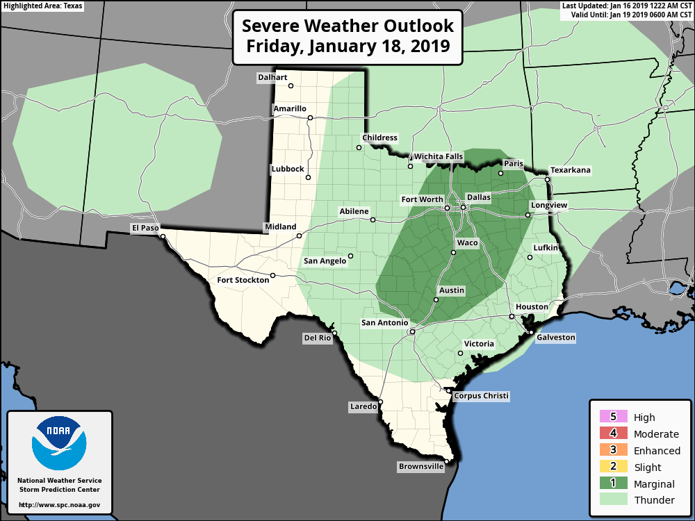 Scattered showers and thunderstorms will persist overnight into Saturday morning as the strongest arctic front of the season arrives during the morning. Current data has been suggesting the possibility of rain transitioning into a wintery mix by Saturday afternoon. Since this is a possibility highlighted by numerous ensemble members, we will introduce a small chance of wintery precipitation on Saturday. It is too early to specific tell exact snow amounts and the exact placement of the system, so be sure you are sticking with the latest forecasts, as this can very well change. Otherwise, mostly cloudy conditions can be expected throughout the day with temperatures going the wrong way, falling below freezing by the afternoon. We transition to brutally cold weather by Sunday, with possible morning lows in the upper teens to low 20s. If that wasn't bad enough, wind chills are expected to be in the teens to single digits throughout the day, not just the morning. Don't let the sun fool you, we will most likely be in the low to mid 30s throughout the day. The good news is, that storm system will be well in the northeast US by then, so no wintery precipitation is expected. NEXT WEEK - Much of next week will feature more clouds than sun with highs mostly in the upper 40s with morning lows in the 30s... See the Texas Weather Discussion Video for more details. 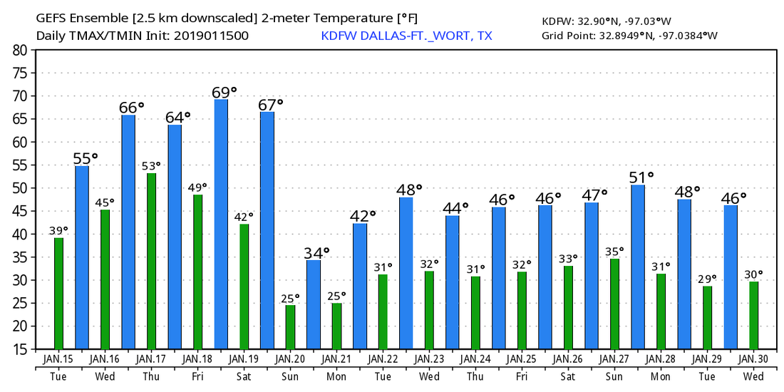 A BIT WARMER THIS AFTERNOON - Clouds have been very persistent across North Texas over the past few days, and they will still hang over the region later today as the sky becomes partly sunny. We project a high in the lower 50s this afternoon. Tonight will be chilly once again with temperatures in the low 40s, and tomorrow will feature partly to mostly sunny conditions with highs in the mid 60s. THURSDAY AND FRIDAY - Thursday will feature a mix of sun and clouds again with afternoon highs in the in the mid 60s. A disturbance will bring widespread cloud cover into the state on Friday, and a few showers are possible Friday afternoon into the evening hours. The warming trend peaks on Friday as temperatures rise into the low to mid 70s. The day will be generally cloudy will only few instances of sun at times. SATURDAY - A dynamic weather system will bring rain to our region early Saturday morning into late-morning. Some lightning is possible, but no severe weather issues are expected due to the lack of instability. The main window for rain comes from about midnight to 10:00 AM, and rain amounts of less than 1/4 inch are likely. We will maintain highs in the mid 40s on Saturday. COLDEST AIR ARRIVES SUNDAY - Piercing cold air rolls into Texas Sunday with a strong northerly wind. Many communities in North Texas will stay below freezing all day, and the north wind of 10-25mph will push the wind chill indices to the teens and single digits all day. I would not be surprised if we see a couple of snow flurries after midnight into early Sunday morning at the artic air intrudes the states, but no accumulation or impacts are expected. The cold air is the main headline. By Monday morning, we project a low in the 20 degree range for North-Central Texas. The day Monday will feature a mix of sun and clouds with highs in the mid 40s. TO THE NORTH - Another snow event is possible this weekend for parts of the Midwest into Northeastern US. Too far out on specific timing, impacts, or amounts. But please exercise caution if you are traveling in those areas. NEXT WEEK - Most of next week will be mostly dry with highs in the upper 40s. Thermal profiles and current upper air pattern suggests that is no evidence of any significant snow/ice event for Texas for the next several days, despite what you might see on Twitter, or what your weather app says. See the Texas Weather Discussion Video for more details.  VERY CHILLY - Temperatures are mostly in the mid to upper 30s across the North Texas region this morning, which is actually above our average high of 35°. We won't warm much today, and afternoon highs will only reach the mid 40s with more clouds than sun, so be sure to dress appropriately for today. REST OF THE WEEK - The good news is, temperatures will slowly moderate throughout the workweek. We will start most days in the 40s, but we will end up in the mid 50s on Tuesday, followed by mid to upper 60s by Wednesday and Thursday. Then, we should peak in warmth by Friday, with highs very close to 70°. Each day will feature a mix of sun and clouds. THE WEEKEND - An arctic outbreak is becoming increasingly likely across the Continental US starting this weekend. An upper high in the Central Plains will allow for an intrusion of cold air to filter into North Texas this weekend. At this point, we are only expecting highs in the low 30s for much of the weekend. Morning lows are expected to be in the low 30s for Saturday, followed by the mid to upper teens by Sunday. However, the wind chill will make forecast temperatures feel like the single digits in most spots. This brutally cold air mass will also feature a mix of sun and clouds throughout each day. Rain is possible early Saturday morning, but the best chance of any one spot getting wet is only in the 10-20 percent range for now. NEXT WEEK - After a brutally cold weekend, we become a bit more average with highs in the low 40s with a mix of sun and clouds for at least the beginning of next week. See the Texas Weather Discussion Video for more details. 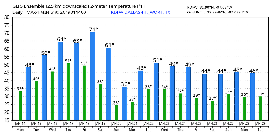 |
Archives
April 2024
Categories |
 RSS Feed