
|
Radar Check - Another round of scattered showers and storms are about in North Texas, which brings some much needed rainfall for parts of the region, as the drought is getting progressively worse.  These should taper off by the afternoon hours, but nothing is in fruition to suggest a widespread rain. Today should be mostly cloudy again with highs in the mid to upper 70s, a few degrees below seasonal temperatures... This should also be perfect weather for high school football games. Football Weather - Comfortable conditions for high school football games tonight; still cloudy with highs in the mid 70s at kickoff, falling into the low 70s by the final whistle. Summit High School takes on Lake Ridge High School at Vernon Newsom Stadium (kickoff at 7:30p). Cloudy conditions are expected with temperatures falling from 74 degrees at kickoff, to near 70 by the final whistle. Bands of America Regional Championships - This Saturday, Bands of America comes to North Texas to host its annual regional championships. This event features some of the best marching bands in the state and also in the area. This event will be hosted at Dragon Stadium in Southlake, Texas. Prelims performances begin at 8:00 AM. The Summit High School Marching Band will be one of the bands performing at this contest (prelims. per. @ 3:15p). The temperature should be around 78-82 degrees by preliminary performance, before warming to the mid 80s by the prelims. results. If we advance to finals, we don't know when we will play again, but when finals performances begin, the temperature should be cooling down to the mid 70s, before reaching to the low 70s by the finals awards announcements. Next Week - I just don't see any reasons to mention any rain for North Texas. Earlier in the week, there were some signs that moisture could increase, but that idea is not even worth mentioning at the moment. We continue to have a dry forecast with highs in the upper 80s with lows in the mid 60s. 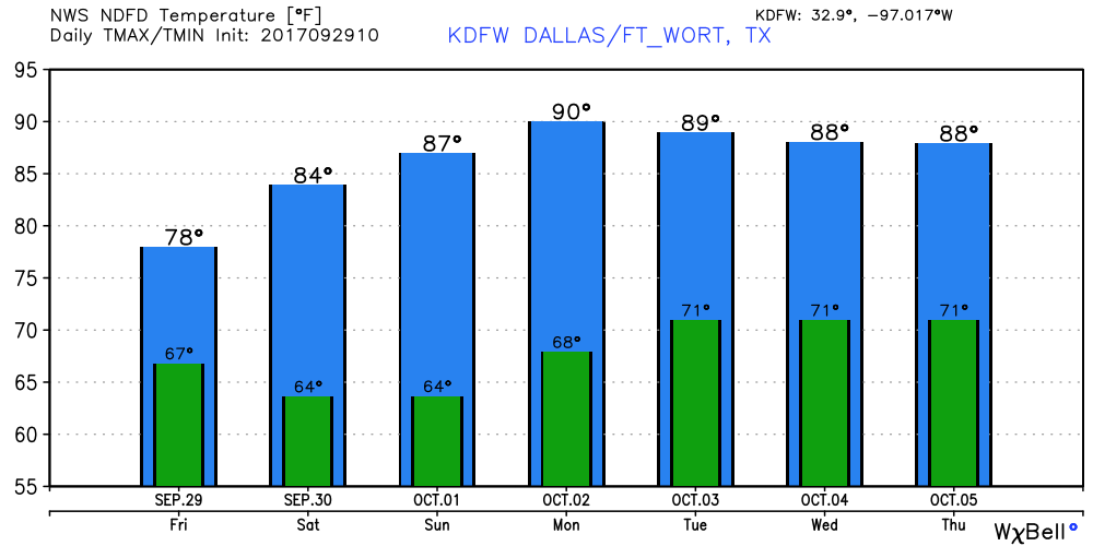 Tropics - Tropical Storm Maria and Hurricane Lee are moving out to sea, away from the U.S. Closer to home, we are monitoring a disturbance located near the southern tip of Florida that has some chance of slow development in the next several days. Tropical Storm or not, this is expected to bring heavy rainfall to Florida's East Coast. This should not be a problem for the Gulf. Speaking of, global models continue to show development in that same region, but should not be a problem for Texas. See the Texas Weather Discussion Video for more details. 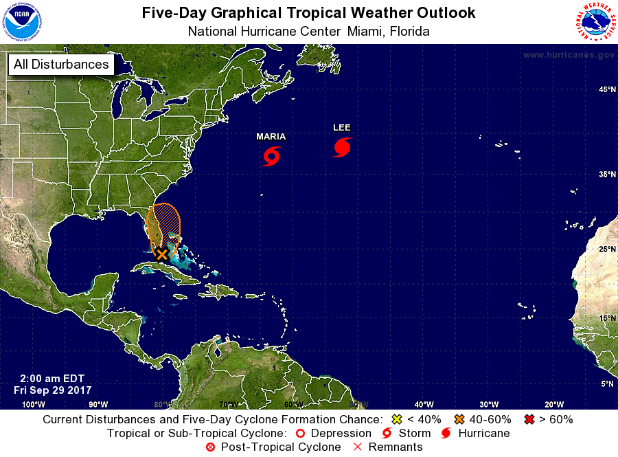 Radar Check - Scattered showers and storms are about in North Texas, which breaks the dry phase in DFW that has been in place for a while now. 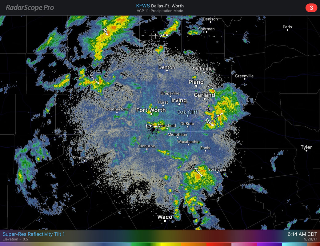 We can't tell you specifically where it will rain due to the scattered nature of the storms, but most of the storms should taper off after noon today. The sky will remain mostly cloudy for today and tomorrow with highs in the 80-83 degree range with lows in the upper 60s. The Weekend - Cloud coverage will lighten Saturday and Sunday with highs in the mid 80s with lows in the mid 60s with some of the naturally cooler pockets in the 70 degree range. Next Week - The pattern starts to look dry again, although, the GFS continues to mention some moisture returning around us. If that continues to be the case, then we might mention a chance of an isolated shower or storm on Wednesday. Otherwise, very little to no rainfall next week with highs in the upper 80s. 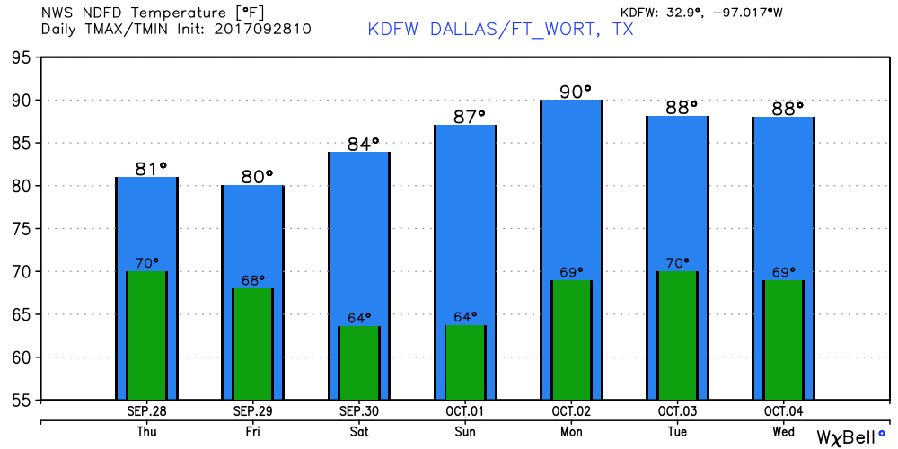 Tropics - Tropical Storm Maria and Hurricane Lee are both in the Atlantic, moving east-northeast away from land. A disturbance near Cuba has a 50/50 chance of developing during the next five days, but either way, that is expected to bring heavy rain to the Florida Peninsula in coming days. Global Models continue to hint at some additional development in the Northern Carribean and Gulf of Mexico during the next week, which is just an idea in fruition that we can't be specific on this early in the game. See the Texas Weather Discussion Video for more details. 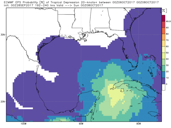 Radar Check - As for most of this week, much of the rain is in West Texas near Abilene this morning. But we do notice a few showers near Chico and Runaway Bay. As we progress through the day, the chances of scattered showers and storms increase, as well as cloud cover. We can't specifically tell you where it's going to rain due to the scattered nature of the storms. The high today should be around 85 degrees. Tomorrow Through The Weekend - We continue the trend of fall-like weather with a chance of scattered showers and storms again on Thursday, becoming fewer in number on Friday. The high on both days should be in between 80 and 83, which will be perfect for high school football games. By the weekend, we should trend drier and sunnier with fewer clouds with highs in the mid 80s, which is perfect if you are going to see some great marching bands play at either Bands of America Regional Championships or Preview of Champions. Next Week - Dry, comfortable weather continues. The global modeling have bounced back the idea of moisture returning sometime next week, but keep in mind that we are entering ONE of the driest parts of the year. 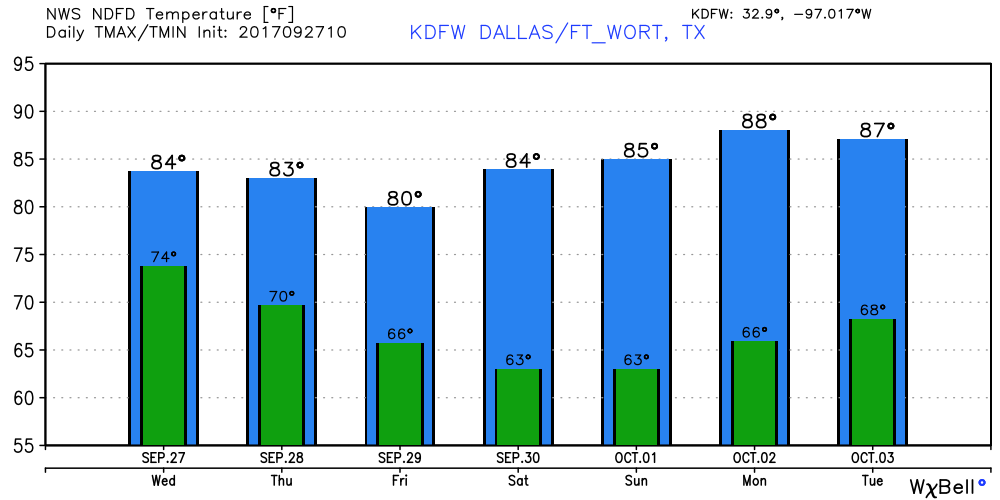 Tropics - Hurricane Lee has max. sustained winds of 110. It will continue to weaken in coming days as it gains latitude and poses no threat to land. Maria has been downgraded to a tropical storm overnight. A tropical storm warning is still in effect for North Carolina's Outer Banks, where winds have reached up to 40 mph there. Maria will continue to drive out to sea later this week. 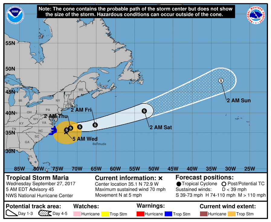 Also, the global models have been hinting at something developing in the Gulf of Mexico or Northern Caribbean. See the Texas Weather Discussion Video for more details.
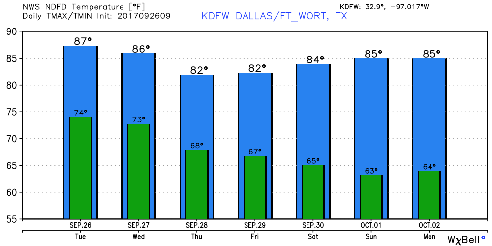
More Dry Days Than Wet - With the cold front coming through our area, some of the public may be thinking the thoughts of "going to rain all week" or "heavy downpours", which is not the case. While some may be disappointed about this, all you need to do is travel to west Texas, where numerous showers and storms have been occurring there since yesterday. Still Summer-Like - We forecast highs close or at 90 degrees for today, but, a great deal of cloud coverage is expected throughout the day. The best chance of any showers occurring around here will be to the west of DFW. But, we can't rule out a shower or two during the late morning hours. Cooler Days - A trough in the western part of the country will help break down the upper ridge, which will bring in a cold front later today that will trend us towards cooler temperatures later this week. Tomorrow we fall to the mid 80s, and by Thursday we fall to potentially the upper 70s for high temperatures. The Weekend - Very pleasant weather is in the forecast for both days - highs 83-87, lows 62-66 with lots of sun. Definitely not sweater weather, but temperatures should be just at or below average for closing September and beginning October. Next Week - Dry, pleasant weather will persistent for most of next week with more sun than this week. We note that the GFS and ECMWF models start to hint towards a surface low forming in the Gulf of Mexico in the next 6-10 days. We will have to keep an eye on any signs of tropical mischief. Tropics - Hurricane Lee, which is in the Central Atlantic, will kick out into the Northern Atlantic in the next few days, posing no threat to land. Closer, Maria is expected to weaken to a tropical storm later today, passing to the east of the North Carolina Outer Banks, where a tropical storm warning is in effect there. This storm should kick out to sea later this week. The rest of the Atlantic, is quiet. See the Texas Weather Discussion Video for more details. 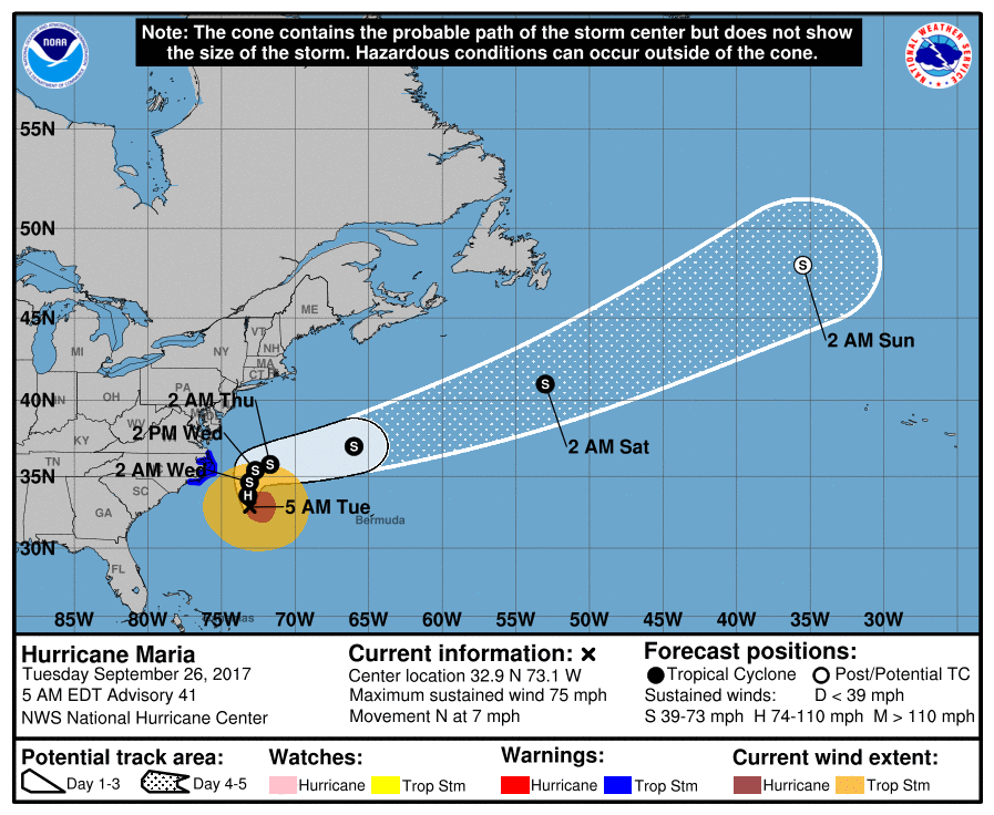 Radar Check - A few showers are located well to the northwest of DFW, near Graham and Jacksboro. They will continue to push to the northeast this morning, but most locations in north Texas should have a nice morning commute traveling to work and school. DFW currently has a temperature of 75 degrees, which is still a few degrees above average. We will have to wait until Wednesday or Thursday to experience any noticeable changes to our weather. Highs will be in the low 90s today with clouds increasing this afternoon and evening. The chance for a stray shower or two is low, but not zero. Letterman Weather - As the cold front arrives, much needed rain becomes possible on Wednesday and Thursday, mainly in the form of occasional scattered showers and storms. But the good news is, highs will only be in the low to mid 80s on both days, with abundant cloud coverage to give you a fall "feel". Friday should also be a perfect day for high school football games with seasonably warm temperatures, a mix of sun and clouds with highs only in the low 80s. Bands of America Regional Championships - This Saturday, Bands of America will host its yearly Regional Championships at Dragon Stadium in Southlake, Texas. The weather throughout the day should be sunny and pleasant with highs in the low to mid 80s with chance of rain almost non-existent. The Summit High School Marching Band will be taking on multiple schools across the metroplex at this competition (prelim. performance at 3:15p). Right now, conditions favor abundant sunshine with the temperature ranging from 80-84 degrees, which should not be too hot if you are planning to go watch some amazing marching bands perform this weekend. Next Week - We stay dry for most of next week, which isn't surprising. Keep in mind that we are in one of the driest parts of the year. Then, we begin late severe weather season in November and December. 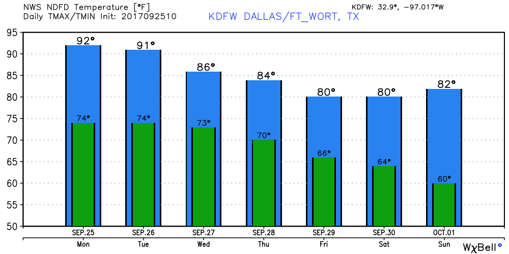 Tropics - Hurricane Lee is a stationary system in the Central Atlantic that is expected to pose no threat to land and kick to the northeast in a few days. Hurricane Maria, which is down to a category 1 storm with maximum sustained winds of 80 mph, will remain offshore, but will come close enough to warrant a tropical storm warning for the North Carolina Outer Banks, where winds could exceed 35 mph. This storm will move away from the coast later this week. 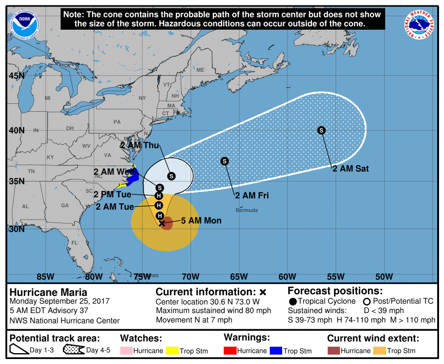 The rest of the Atlantic Basin, including the Gulf of Mexico, is quiet. See the Texas Weather Discussion Video for more details.
If anyone remembers the lyrics to this song, raise your hand... “Do you remember the 21st night of September? Love was changing the minds of pretenders While chasing the clouds away Our hearts were ringing In the key that our souls were singing. As we danced in the night, Remember how the stars stole the night away” When lyrics like these come into fruition, you know that it is almost time for fall. The autumnal equinox begins today at 3:02 PM. Meteorological Fall began since September 1, but astrological fall begins at 3:02 this afternoon. This is where the sun is directly over the equator, and should have 12 hours of sunlight and 12 hours of darkness, as a result. Keep in mind that it does not magically turn cooler on the first day of fall; we will have to wait until next week to have any fall-like weather. Upper Ridge Holds Into the Weekend - Today and throughout the weekend, we will continue to be in a hot and humid pattern for most of the day. The presence of an upper ridge means hot and potentially humid days, fair nights, with little to no rainfall. Widespread rain is not expected until sometime next week. Highs will be in the mid 90s today, but it should not be as hot as the past two days. Football Weather - For tonight's high school football games, it should be very warm and humid with temperatures at 85-90 at kickoff, falling into the low 80s by the final whistle. Summit High School will be on the road this evening as they will be taking on Waxahachie at an away conference game (kickoff at 7:30p). As the sun sets, we expect a clear sky with highs in the low 90s at kickoff, falling into the low 80s by the fourth quarter or the final whistle. Pattern Change - As a cold front comes through our area early next week, it should be noticeably cooler with highs in the low 80s, perhaps reaching down into the 70s in some days. Also, the chance for scattered showers and storms will also increase, mainly by Wednesday. Additionally, a trough in the central Plains will begin to develop, which will suggest a pattern change for the central, and southern U.S., according to global models. This will open the door for much cooler weather for North Texas as September comes to a close. However, we should still stay dry as October is usually one of the driest months of the year. 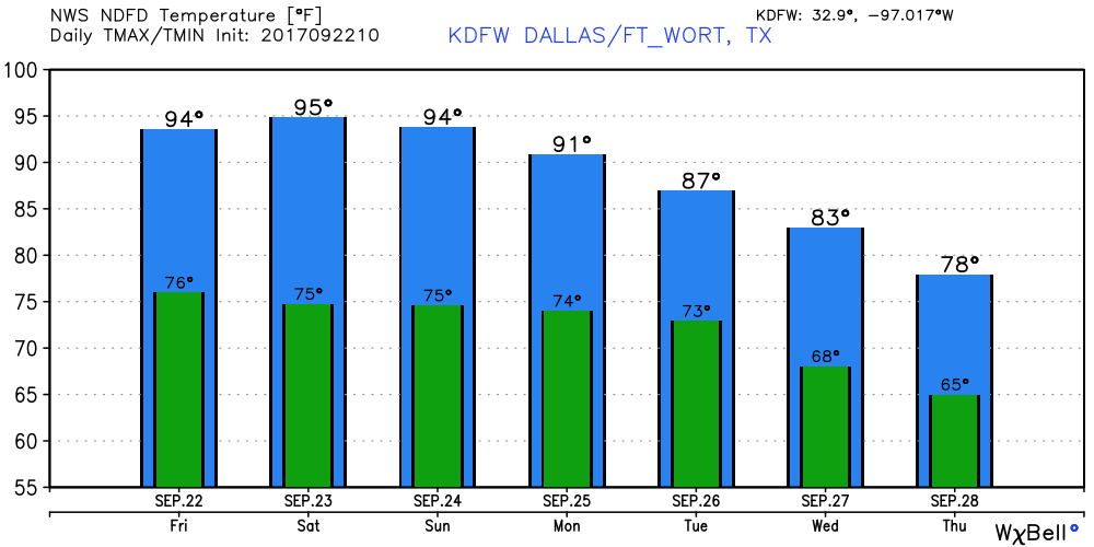 Maria Still a Hurricane - Maria is still a Category three hurricane with maximum sustained winds of 125 mph with a northward movement of 7 mph. It will impact or stay just to the east of the Caicos and Turks Islands today, well to the east of the Bahamas. 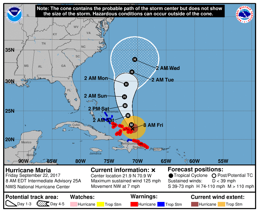 By the middle of next week, the eye should end up somewhere between the East Coast and the Bermuda as a category one hurricane. Most global and ensemble models continue to take this out to see without making landfall anytime soon.
Also, Jose is now a post tropical cyclone near Cape Cod still. It should continue to hang around that area for a few days before dissipating. As expected, most locations in north Texas are starting the day in the upper 70s to low 80s as the upper ridge continues to hold. As a result, we should warm to the mid to upper 90s today, with heat index values in the triple digits in some spots again today. Tomorrow Though the Weekend - As the upper ridge holds in north Texas, we should expect partly sunny days, fair nights, with highs remaining in the low to mid 90s, which is about 8 to 10 degrees above average. We should also mention that this weekend will be the first weekend of fall; the autumnal equinox will begin at 3:05 PM on Friday. Football Weather - For the Friday night high school football games, it should start in the low 90s in most places at kickoff, with temperatures falling into the low 80s by the final whistle. This week, Mansfield Summit High School will take on Waxahachie tomorrow night (kick off at 7:30 PM). As the sunset, temperatures should be in the low 90s, before cooling off into the mid to low 80s by the fourth quarter. Next Week - We embark on a cooling trend. As the late September cold front arrives early next week, we should notice a significant change. A cold front arrives early next week, which will leave behind significantly cooler temperatures along with a chance of scattered showers and storms for multiple days. Additionally, the global forecast models (GFS/ECMWF) is suggesting a major pattern change by the end of September which will bring refreshing air into the south as October begins. 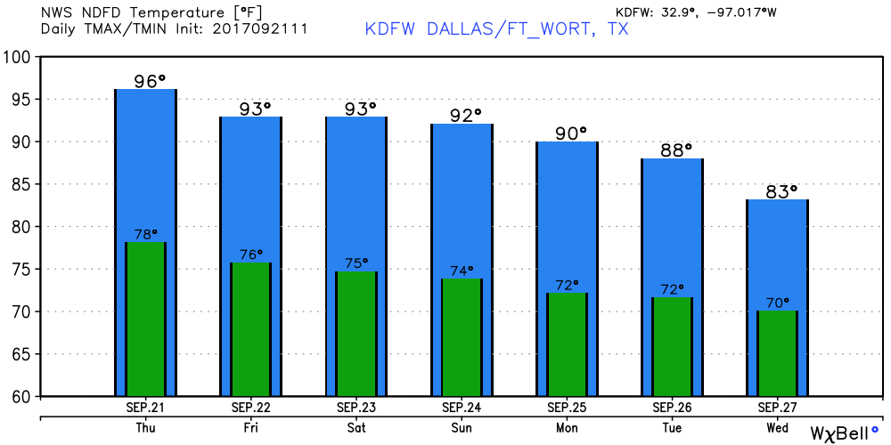 Maria - Maria is now a category three hurricane with maximum sustained winds of 115 mph. The eye of the storm has emerged from Puerto Rico, and is back into open water. This should gain latitude and move to the north, staying well to the east of the Bahamas. 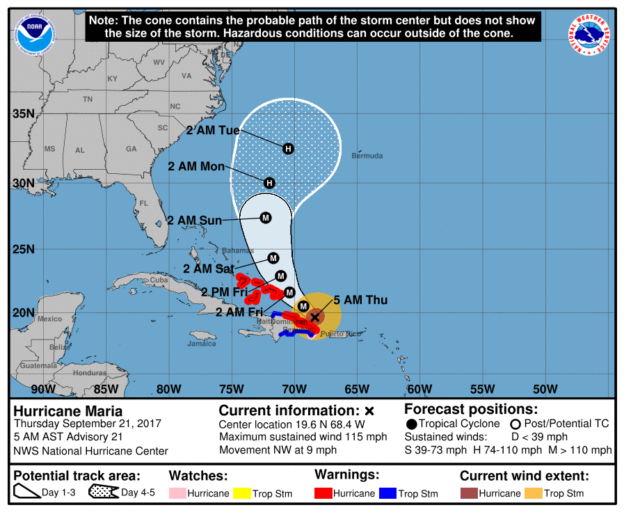 Confidence is increasing that this storm will NOT affect the East Coast thanks to a sub-tropical ridge left by Tropical Storm Jose, which is still spinning in New England. See the Texas Weather Discussion Video for more details.
Getting Warmer - As we have been trending warmer for the last few days, we start the morning commute in the upper 70s to the low 80s. DFW Airport had temperature of 79 degrees at 6:09 AM. Highs today in the upper 90s for most spots today, but please note that it may feel a lot hotter than that due to heat index values potentially in the triple digits. With a ridge still in our area, if any showers and storms makes it to DFW, they should be far and few between today. The chances of rain is not zero today, but very low. One or two spots may see a passing shower during the afternoon/evening hours, if you are lucky. For the Rest of the Week - Temperatures should cool off by a few degrees as we get closer to the weekend. Other than that, we continue to forecast a sunny sky and fair nights with highs in the mid to low 90s. Showers may be possible each day, but will remain few and far between and the chances should ultimately remain very low. The Weekend - Not much change to mention as the upper ridge holds. Partly sunny, very warm days with highs in the low 90s, along with scattered clouds at times. And a persistent forecast is set for early next week. Highs will continue to hold into the upper 80s in most spots. There are some signs of a strong cold front coming through by the latter half of next week, which will open the door for rain chances and some cooler temperatures as October begins.... 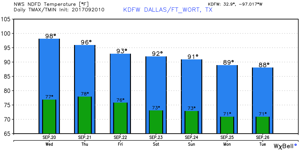 Major Hurricane Maria - This is still a dangerous, life-threatening category four storm with maximum sustained winds of 155 mph. It is making landfall in Puerto Rico now, the strongest hurricane to make landfall in that island on record. 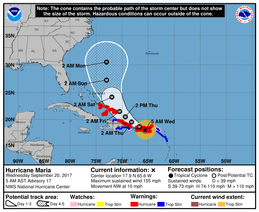 A Hurricane Warning is in effect for...
* U.S. Virgin Islands * British Virgin Islands * Puerto Rico, Culebra, and Vieques * Dominican Republic from Cabo Engano to Puerto Plata * Turks and Caicos Islands and the Southeastern Bahamas This storm will continue to move to the northwest at 10 mph, keeping that same component of motion through tonight. On its forecast cone, it should steer to the north of the Dominican Republic, and may make landfall on the Turks and Caicos Islands overnight. This storm is expected to remain a dangerous category four hurricane until it moves out of the Virgin Islands or Puerto Rico. This storm will gain latitude, then continue northwestward, staying to the east of the Bahamas. Confidence is increasing that this storm will still not affect the East Coast or the Gulf of Mexico, but we still will have to keep our eyes peeled. There is a good chance that Josè will leave a weakeness in the ridge, which will allow Maria to escape without impacting the East Coast. See the Texas Weather Discussion Video for more details. Summer-Like Weather Continues - An upper-level ridge will continue to stay on top of North Texas, meaning summer-like weather will prevail. We continue to forecast highs in the 90-95 degree range with a mostly sunny sky with a few clouds throughout the day. Rain chances will continue to remain very low today, the better chances will go towards West Texas. If we do see anything on the radar today, it will be in the form of widely scattered, random showers that will quickly dissipate. This will be the case for most of the week. Little to no rainfall in North Texas is expected as a result of the warm air associated with the upper ridge. The summer pattern continues - mostly sunny days with fair nights, with high temperatures holding in the 90-95 degree range. The chances of showers will continue to be to the west and southeast of DFW. The Weekend - Not much change. Highs will continue to hold in the low 90s with only a slim chance of an isolated shower or storm. Next Week - Though the ridge continues to hold, we mention a slight chance of showers and storms early next week, mainly during the afternoon/evening hours. The best chance of one spot getting wet is in the 10-20 percent category, but no signs of any widespread rain any time soon. Highs should drop to the mid to low 80s as the ridge weekends and fall magic comes into play. 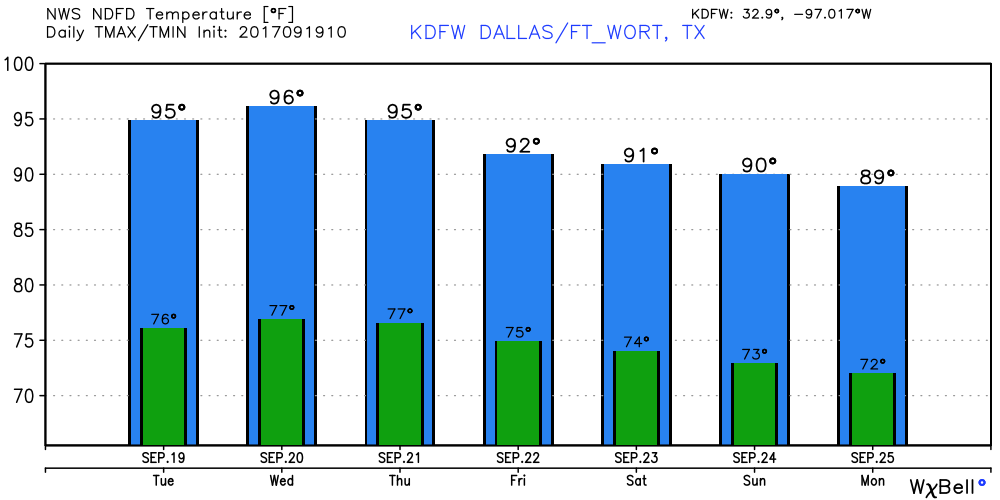 Tropical Weather - Lee is now just a remnant circulation in the Atlantic Basin, which brings us down to two active storms... Jose - Jose is still hanging on as a minimal hurricane with maximum sustained winds of 75 mph. It should weaken to a tropical storm tonight. The center circulation will remain offshore, but is enough to warrant a tropical storm warning for Cape Cod. It will attempt loop well to the east of New England, before becoming post-tropical cyclone by this weekend. 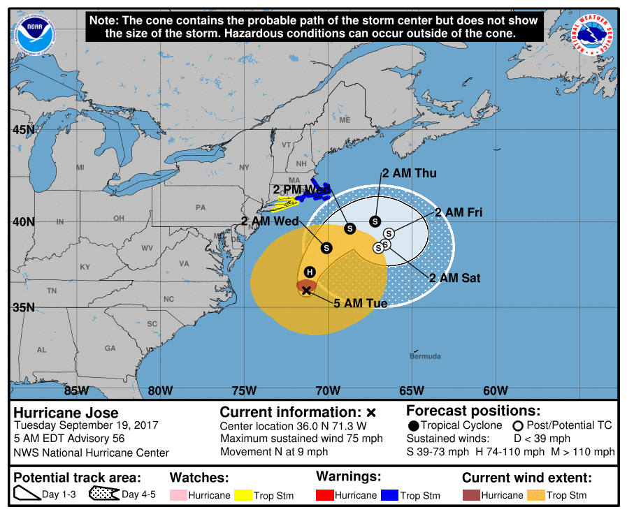 Maria - Maria is an extremely dangerous and life-threatening category five hurricane on the Saffir-Simpson Scale. The eye went over the Dominica Islands last night as a category five. It has maximum sustained winds of 160 mph. This storm may fluctuate in intensities, but is still forecast to remain an extremely dangerous category four or five storm as it makes its way towards Puerto Rico. 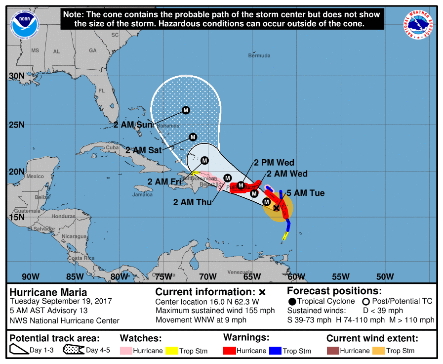 A Hurricane Warning is in effect for...
* Guadeloupe * Dominica * St. Kitts, Nevis, and Montserrat * U.S. Virgin Islands * British Virgin Islands * Puerto Rico, Culebra, and Vieques A Tropical Storm Warning is in effect for... * Antigua and Barbuda * Saba and St. Eustatius * St. Maarten * Anguilla * St. Lucia * Martinique A Hurricane Watch is in effect for... * Saba and St. Eustatius * St. Maarten * St. Martin and St. Barthelemy * Anguilla * Isla Saona to Puerto Plata A Tropical Storm Watch is in effect for... * St. Vincent and the Grenadines * West of Puerto Plata to the northern Dominican Republic-Haiti border This storm will continue to gain latitude as it moves to the northeast. Confidence is increasing that this storm will not impact the Gulf of Mexico or Florida. See the Texas Weather Discussion Video for more details. DFW starts the day in at 71 at 5:38, which is, of course a noticeable change from yesterday. But, most locations are currently in the 60s to start the day. That is a change from recent days, and will continue to stay like that for the next several days. Tomorrow Through the Weekend - A pattern change will be coming. The circulation over the southeast U.S (formally Irma) will lift to the northeast, and an upper ridge will start to build. To the west, a cold, upper trough will develop over the northwest U.S, where some people in Montana and Wyoming are under Winter Storm Warnings. In north Texas, we forecast mostly sunny and hot days with cool nights with very little to no precipitation expected. Highs will stay in the low to mid 90s for the next 9-10 days. Football Weather - The weather looks really good for some high school football today and tomorrow. The temperature should start at or near 91 degrees at kickoff, cooling off at 82-85 degrees by the fourth quarter/near the end of the game. Next Week - The upper air pattern holds. Warm and hot for the south and east U.S. including north Texas, and cold to the northwest. For north Texas, conditions will continue to be dry and hot with highs in the low 90s. See the Texas Weather Discussion Video for more details. 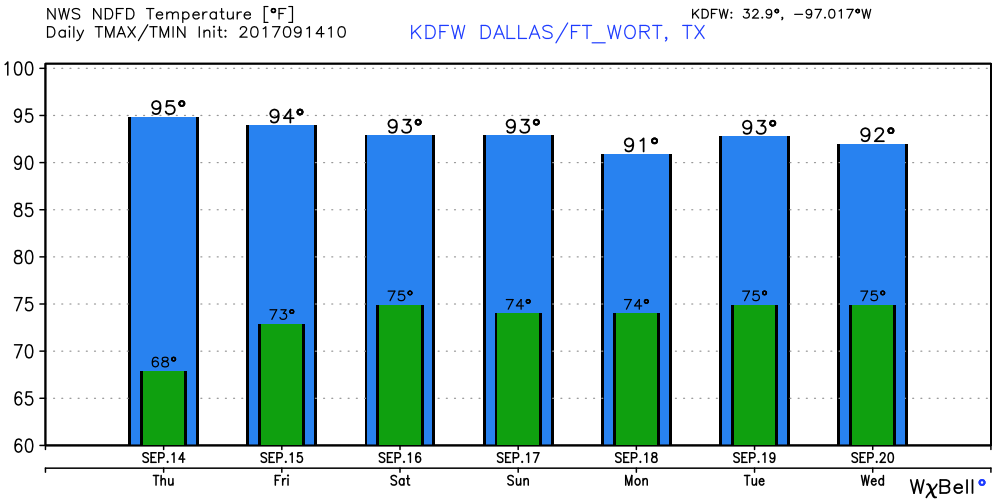 Jose - Jose is still a minimal hurricane with maximum sustained winds of 75 mph. It is in the Atlantic, well to the north of Puerto Rico and the Bahamas. It is expected to make a turn to the north and continue to the northeast as a hurricane. The NHC track keeps the storm well to the east of the U.S. The rest of the Atlantic is quiet. 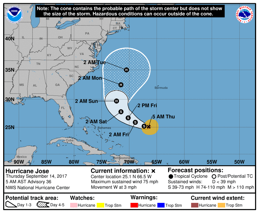 As we start the morning, we notice a few clouds that are still lingering in North Texas. They should clear by the afternoon and evening hours today, and we should remain dry with highs in the low 90s, with the temperature increase throughout the week. Tomorrow and Friday - As the upper-level ridge starts to build, we should continue to see temperatures increase to the mid to upper 90s by Thursday and Friday afternoon with plenty of sunshine. Showers on any of these days should be non-existent. The Weekend - Not much change. Hot and dry weather will continue for Saturday and Sunday. Highs should still be in the mid 90s for both days, with showers being very hard to find. Next Week - As the upper ridge holds in the south, hot and dry weather will still prevail with highs in the mid 90s and lows in the 70s. A shower or two may pop-up early in the week, but nothing suggest a widespread rain. See the Texas Weather Discussion Video for more details. 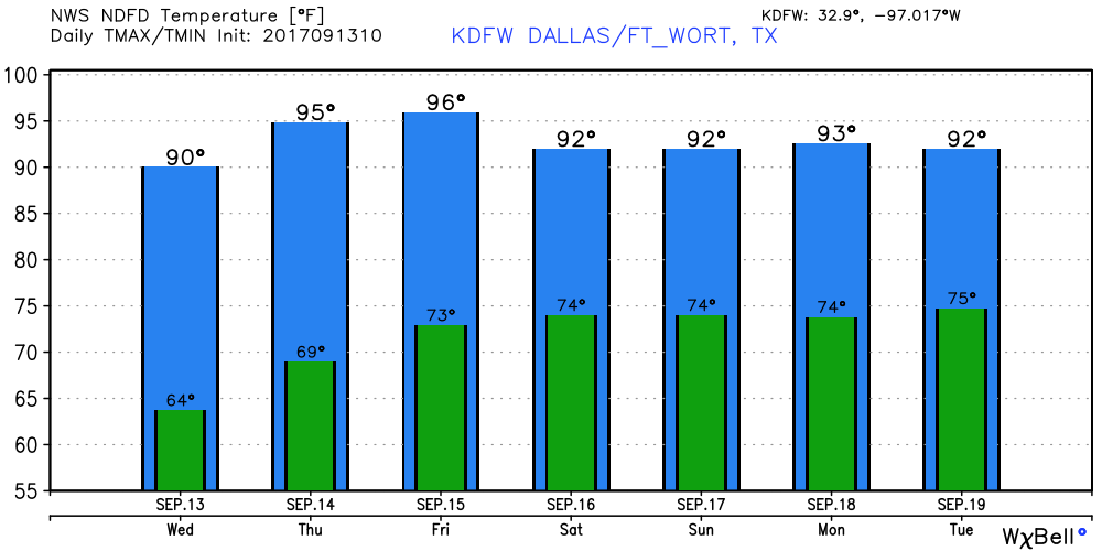 Hurricane Jose - Jose is well to the north of Puerto Rico, and to the northeast of the Bahamas with maximum sustained winds of 75 mph. This storm is expected to make a loop before continuing to the northeast as a tropical storm. 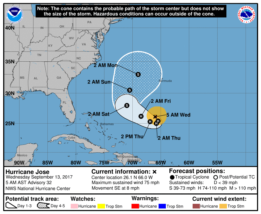 The global models continue to suggest that this will move northeast and not affect the East Coast, but it is too early to know its final destination.
Like recent days, we start the day out in the 60s of all kinds, with some of the naturally cooler pockets in the 50-degree range. Better enjoy the last day (or two) of this for a while, because lows in the 70-degree range is likely as the upper-level ridge kicks in. Expect highs in the mid to upper 80s for today, but that will quickly change within a day or two. An increase in cloud coverage is possible later today as the remnant circulation of Irma continues to move to the northwest. We are just on the edge of drier air and we could see clouds as Irma progresses to the north-northwest. Tomorrow Through Friday - As a warming trend begins, we reach the low 90s by Wednesday, warming into the mid 90s by Thursday and Friday. We will still hang on to a couple of clouds throughout the day, but we should see abundant sunshine during the day on Thursday and Friday. The Weekend - Sunny, hot days and warm nights during the weekend with highs in the middle 90s and lows in the mid 70s, back to seasonal levels for this time of the year. Next Week - The majority of the week should be hot and dry as the upper ridge continues to hold. Highs will continue to be in the middle 90s. Irma? - Irma is now a post-tropical cyclone storm that is continuing to move to the northwest. All watches/warnings of this storm has been allowed to expire as this storm no longer poses a serious threat to life or property. Here is the final advisory from the National Hurricane Center. 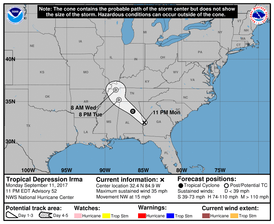 Jose - Jose currently has maximum sustained winds of 75 mph, and is expected to weaken to a tropical storm for a bit, before intensifying into a hurricane by Thursday, well to the north of Puerto Rico. The mean in the GFS ensemble continues to do a full loop in the Atlantic during the next five days. There is still uncertainty about this, and we will just have to worry about this with time. See the Texas Weather Discussion Video for more details. 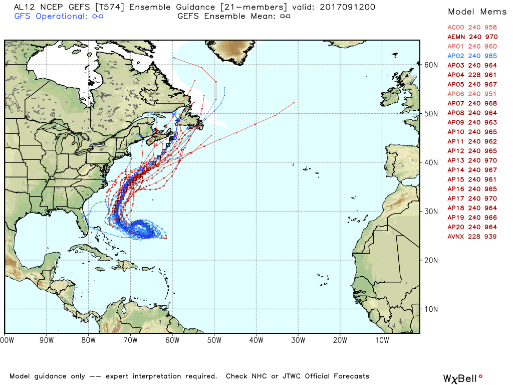 Today we continue to start the day with (sort of) fall-like temperatures in the 60s with some cooler pockets reaching towards the 50s. Don't get too caught in this, as we are expected to warm to the mid to upper 90s during the latter half of the week as ridging in the upper-levels gets involved. But enjoy highs being in the mid 80s today while you can with abundant sunshine. Mid-Week - As ridging gets involved and Irma dissipates, we should continue on a gradual warming trend before peaking during Friday, where highs are expected to be somewhere between 93 and 97. We should also see a few clouds here and there as well. Thursday and Friday also looks great for high school football, as always. :) The Weekend - Not much change. We continue to stay in ridging, which will create mostly sunny and hot conditions. Highs will continue to range between 93 and 96 degrees with lows in the middle 70s. Next Week - Very little change. We continue to stay dry for virtually all of next week. The one chance that we might see some precipitation would be next Tuesday, but due to ridging in the upper-levels, most locations will continue to stay dry. Highs will be in the low 90s. Irma - Hurricane Irma (now a category one storm) made landfall yesterday near Key West at 9:10 PM EDT. This is the first time in U.S. history that two category four hurricanes made landfall in the continental U.S. in the same year, and let's keep it that way. At 4:00 AM CDT, Irma was located near Crystal River, with maximum sustained winds of 75 mph. This storm will continue to move to the north-northwest at 18 mph weakening to a tropical storm later today, before becoming post-tropical cyclone by Wednesday night. 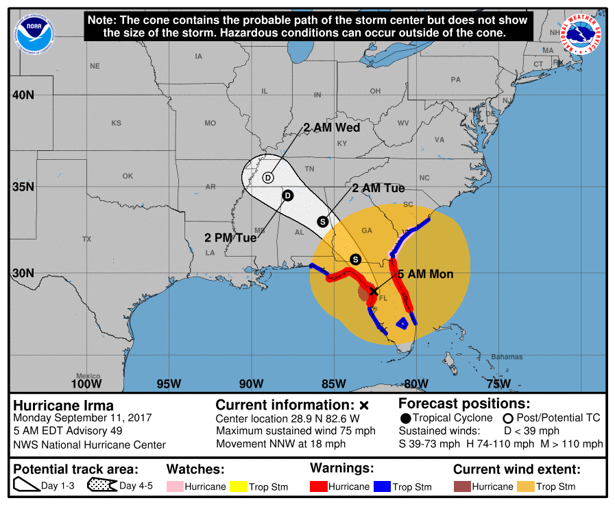 Those that are to the northeast of the circulation will still have to deal with an isolated tornado threat. Those of you that are in Alabama (which is experiencing some of the storm's effects) will have no tornado threat. Again, this storm should become post tropical-cyclone by Wednesday night. Jose - The other Hurricane that is located in the Atlantic is located a few hundred miles north of the Dominican Republic... 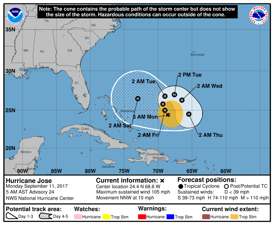 This storm is expected to make a U-turn into the open Atlantic, staying in open water, or just off of the East Coast, with some uncertainty involved. See the Texas Weather Discussion Video for more details.
Sunny, Pleasant Mornings, Cool Nights - Although a tad warmer than yesterday, most locations in north Texas start the day in the 50s, with DFW in the 66 degree range. There is no reason to derail from the same forecast since last week - Pleasant days with abundant sunshine, and calm and cool nights. Today and tomorrow's high will be in the 85-87 degree range, warming up to the upper 80s/low 90s by early next week. A perfect evening/night is in store for us for those who are traveling to see high school football; clear skies with temperatures falling into the mid 70s. Summit High School will be taking on Chisolm Trail at an away game Friday evening (kickoff @ 7:30p). As the sun is setting, the sky will be clear with temperatures starting at 82 at kickoff, dropping to near 75 at the end of the game. Thropics - There are currently three active hurricanes in the Atlantic - Katia, Irma, and Jose. Katia is located in Gulf, and is expected to make landfall on Mexico's coast tonight. No impacts on Texas or the U.S. The second hurricane is trailing Irma. Moving to the northwest, this still remains a major (category) hurricane with maximum sustained winds of 125 mph. This is expected to skirt the northern Leeward Islands before going back into open water and sitting for a few days as steering currents collapse. It remains unknown If Jose will be washed away or if it will try to turn west. The GFS ensemble members have this turn northeast. Dangerous Situation Unfolding for Irma - When it comes to Irma, nobody should be throwing the words "downgraded" as this is still a dangerous category four hurricane with maximum sustained winds of 150 mph. 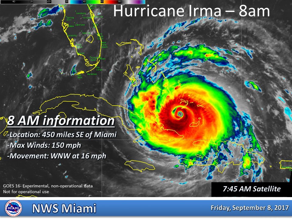 This storm should move away from the Turks and the Caicos this morning and should begin entering the southern Bahamas. The hurricane will move between the Bahamas and Cuba during the next two days, then making a hard right turn towards the Florida Keys and the Penisula. 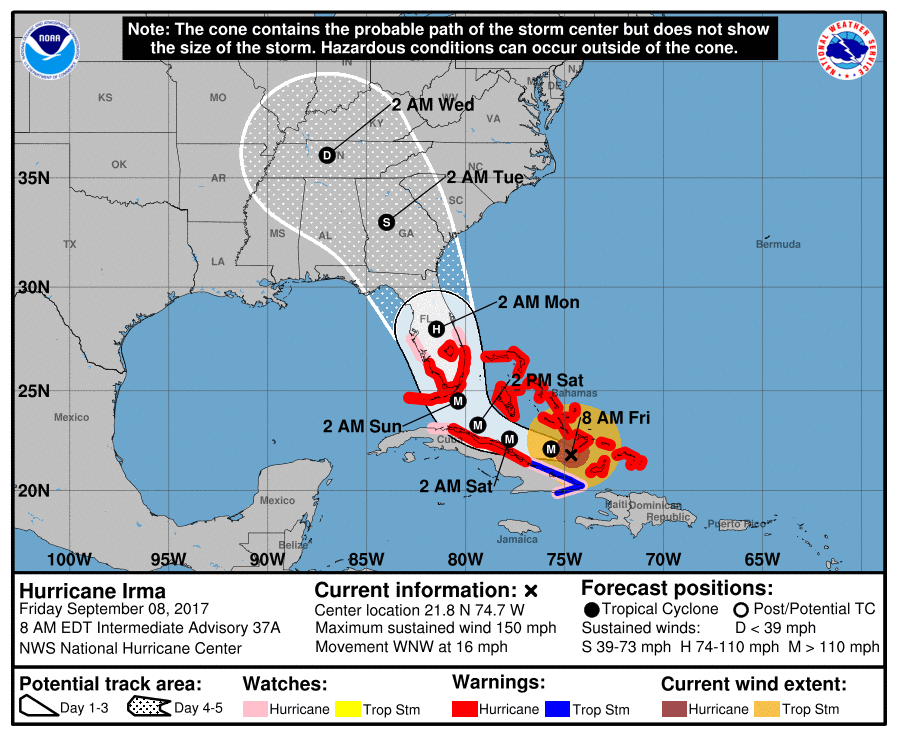 Sadly, the NHC track has this hitting south Florida directly.
Here are the notes: FLORIDA EAST COAST: The most severe storm surge and wind damage will be along Florida’s East Coast… from Miami up to Jacksonville. Structural damage is likely along with storm surge flooding. Widespread power outages are expected as well. Evacuation orders have been issued for much of the coast, people need to heed those orders. ORLANDO: Hurricane force winds are likely in Orlando Sunday and Sunday night. This could bring some structural damage and widespread power outages. The weather improves Monday, but keep in mind there could be infrastructure damage from the storm. If you have a trip planned to Disney World next week, keep an eye on their Twitter feedor FB page. FLORIDA WEST COAST: Cities like St Petersburg, Tampa, Sarasota, Fort Myers, and Naples will have lots of wind and rain Sunday. There is potential for scattered structural damage and widespread power outages. But, the most severe damage will be over on the Atlantic coast. FLORIDA PANHANDLE/ALABAMA COAST: While it will be windy Sunday night and Monday (a north, offshore wind), places like Gulf Shores, Pensacola, Navarre Beach, and Destin should be dry. Winds will be higher at Panama City Beach Monday, in the 25-35 mph range, with some rain possible, but the main impact of Irma will remain to the east. Winds will diminish Tuesday and the weather looks great for the rest of the week. If I had a vacation trip planned to Panama City Beach, I would go without hesitation. GEORGIA/SOUTH CAROLINA: Atlanta could see winds in the 30-40 mph range late Monday night and Tuesday as the circulation center passes pretty much over the city; there could be some trees blown down and scattered power outages, but noting widespread is expected. A few isolated tornadoes are possible Tuesday over East Georgia and South Carolina.Lots of wind and rain for the Georgia and lower South Carolina coast Monday, but Irma will not make a landfall on the the coast there based on the latest NHC forecast. REMEMBER: There is a flood of weather information floating around social media… some good, some bad. Stick with a reliable source, or the official products from NHC. And, if you are using a forecast that is more than six hours old, it is bad information. Use the most current update. Sweater Weather? - Down here in the south, we are enjoying the coolest morning in 6 or 7 months. At 5 AM, DFW Airport recorded a temperature of 66 while Arlington had a recorded temperature of 53! This is 10 to 14 degrees below average for lows. Today will feature abundant sunshine in full force with highs in the low to mid 80s with no rain at all. We are expected to stay this beautiful during the weekend as well - lots of sunshine with cool nights and highs in the low to middle 80s for the weekend. Football Friday - Tomorrow will be a perfect day for high school football games during the late evening/night hours. With the sun just starting to go down at around kickoff times, the sky should be clear with temperatures ranging from 82-85, dropping to the mid to upper 70s by the end of the game. Tomorrow, Mansfield Summit High School takes on Chisolm Trail at an away game tomorrow evening (kickoff at 7:30p). The sky will be clear and beautiful with the temperatures nearing the 70s, dropping to the mid and upper 70s near the final whistle. Next Week - Texas continues to stay in a dry airmass, which will create plenty of sunshine with highs in the upper 80s to low 90s. We could start to warm up a tad by the latter half of the week. Threopics - There are currently three active hurricanes in the Atlantic right now; Katia in the Southwest Gulf of Mexico near the Bay of Campeche, Irma to the north of the Dominican Republic, and Jose out in the open Atlantic. This is the first time we have had three active hurricanes in the Atlantic Basin since 2010.  Katia is a minimal category one hurricane that will move into Mexico later this week, posing no threat to Texas or the Gulf. Jose will continue to stay over open water for the next week... We currently do not know if this will just churn in open water for all of its life cycle, or if it will turn to the U.S. Way too early in the game to predict. IRMA IS STILL A DANGEROUS CATEGORY FIVE - Irma still has maximum sustained winds of 180 mph. With Irma still a category five storm, some hiccups in the intensities is possible as it reaches more land, but is still expected to remain a dangerous category four/five hurricane for the next several days. Irma is moving to the northwest at 15 mph, and is expected to end up near the central Bahamas on Friday. A Hurricane Watch will likely be issued for the southern Florida coast and Florida Keys.  This storm is expected to make a sharp right turn near Cuba, and will end up near Miami, Florida by Sunday morning. From there, this will skirt or be just off of the Florida Atlantic Coast, making second landfall near Savannah, Georgia by Monday evening.
Here are some things to think about... *Don’t focus on the exact track since the average NHC track errors at days 3, 4, and 5 are about 120, 175, and 225 miles, respectively. *Those on the Florida Atlantic coast (Miami, Fort Lauderdale, West Palm Beach, Daytona Beach, Jacksonville) need to continue preparations for a major hurricane, and heed evacuation orders from local officials. *For the west coast of Florida (places like Naples, Fort Myers, Sarasota, St. Petersburg, and Tampa, lots of wind and rain are likely Sunday, but the most severe impact from Irma should be to the east. *Concerning Orlando and Disney World, Sunday will be very wet and windy, but for now it looks like the highest impact will be a little east of there. The weather will improve greatly Monday. *Those on the Georgia and South Carolina coasts need to prepare now for hurricane conditions expected Monday or Monday night of next week. For now, the NHC forecast has Irma as a category two at the time of landfall in this region, but remember the skill set in forecasting hurricane intensity is not especially high at 120 hours. Sweater Weather? - At 5:21 AM, DFW recorded a temperature of 67 degrees. Generally, mostly all of North Texas is in the low to mid 60s this morning, which the naturally colder pockets reaching down towards the low 50s, maybe even into the 40s. This is the coldest North Texas has been in three months, which is a great sign that fall-like weather is on the way. Rain is not expected for North Texas for the next week or two. So we will continue to stick with abundant sunshine with clouds out at times with highs in the low to mid 80s through the weekend. The morning lows will continue to peak near the mid 60s, with some of the naturally cooler spots reaching towards the mid 50s. The weather will continue to stay very pleasant for high school football games on Friday and the weekend. This week, Summit High School will take on Chisolm Trail on Friday (kickoff at 7:30p). The sky will continue to be clear with highs dropping to the upper 70s after sunset. Next Week - Not much change. Hurricane Irma and Tropical Storm Katia will stay to the east and south of us to affect anything in North Texas. We stick with pleasant conditions with abundant sunshine along with mid 80s for the high temperature. 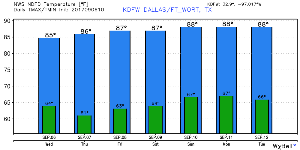 IRMA IS STILL A DANGEROUS CATEGORY FIVE HURRICANE - Irma continues to have maximum sustained winds of 185 mph, which is tied to the second strongest hurricane on record in the Atlantic basin. Hurricane Allen (1980) continues to be number one with maximum sustained winds of 190 mph. 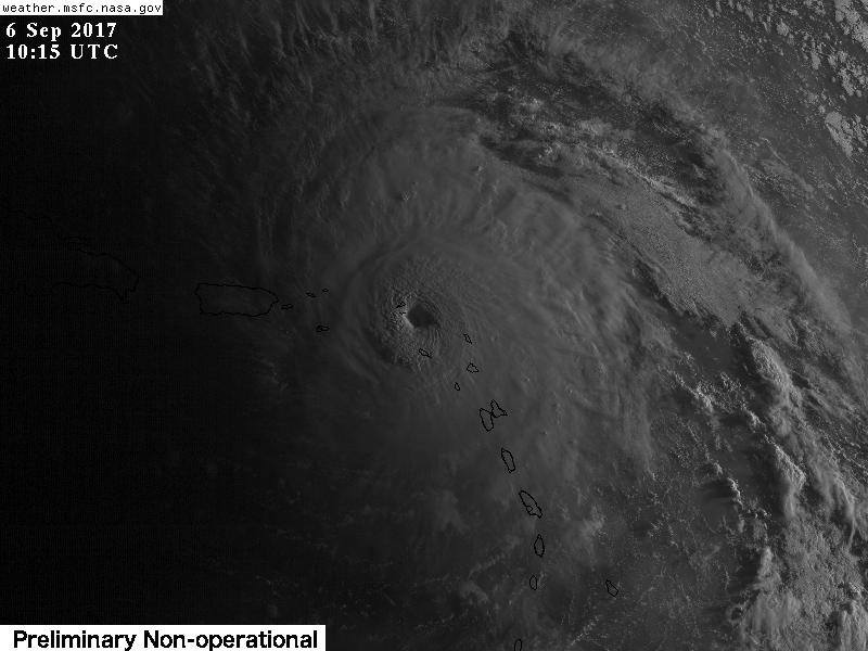 This hurricane is expected to take a sharp right turn to the right when approaching northern Cuba in response to an upper trough in the Northeast US. Models continue to show the storm moving more to the east, and the NHC respectively adjusts their forecast as well. 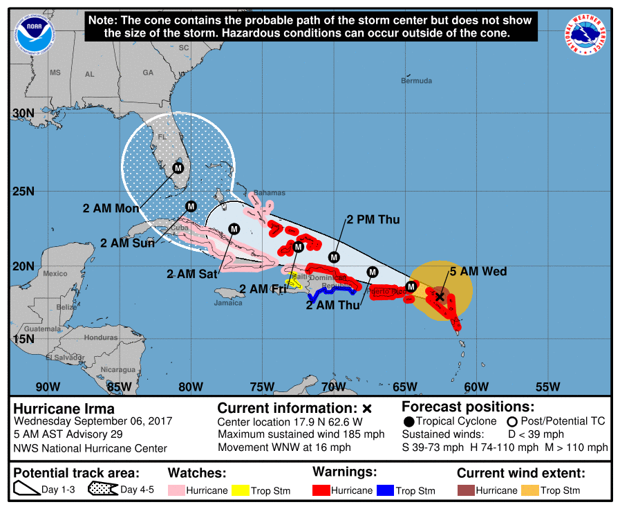 As models suggest, Irma is likely peaking in intensity at this time. Irma maybe on a weakening trend by the time it nears Florida due to land interaction. This will still remain a dangerous and potentially life-threatening major hurricane. Some notes while we le we get through this... *Don’t focus on the exact forecast track, especially at the longer ranges, since the average NHC track errors are about 175 and 225 statute miles at days 4 and 5, respectively. *There is a chance that Irma will follow a path similar to Matthew last year, with the center staying just offshore (east of the Florida Atlantic coast). But, there is also a chance the center comes right up the spine of the peninsula. One way or another everyone in the Florida Peninsula needs to continue preparing for a major hurricane. *Both major global models (ECMWF and GFS) now suggest a landfall somewhere on the coast of South Carolina Monday or Monday night. While the most severe impact will be along and north of the point where this landfall happens, people from Jacksonville to Savannah to Charleston to Cape Fear need to be ready to prepare for hurricane conditions as a course of least regret. *It is still a little too early to give specific impacts (wind speed, rain amounts, storm surge, etc) for any given point along the potential path of Irma across the Florida Peninsula, or the coasts of Georgia or the Carolinas. *Be sure you are using current information if you are in the areas potentially impacted by Irma. If you are working with a forecast more than six hours old, that is bad information. And, be sure and heed any advice given by local officials. Tropical Storm Jose - This is the system in the Atlantic that is trailing Irma that is expected to become a hurricane during the next 24 hours. It should stay well to the north of the Leeward islands. Afterwards, due to weak steering currents, it will most likely hang in open water for the next several days. Does not look like an impact to land, but will continue to monitor... 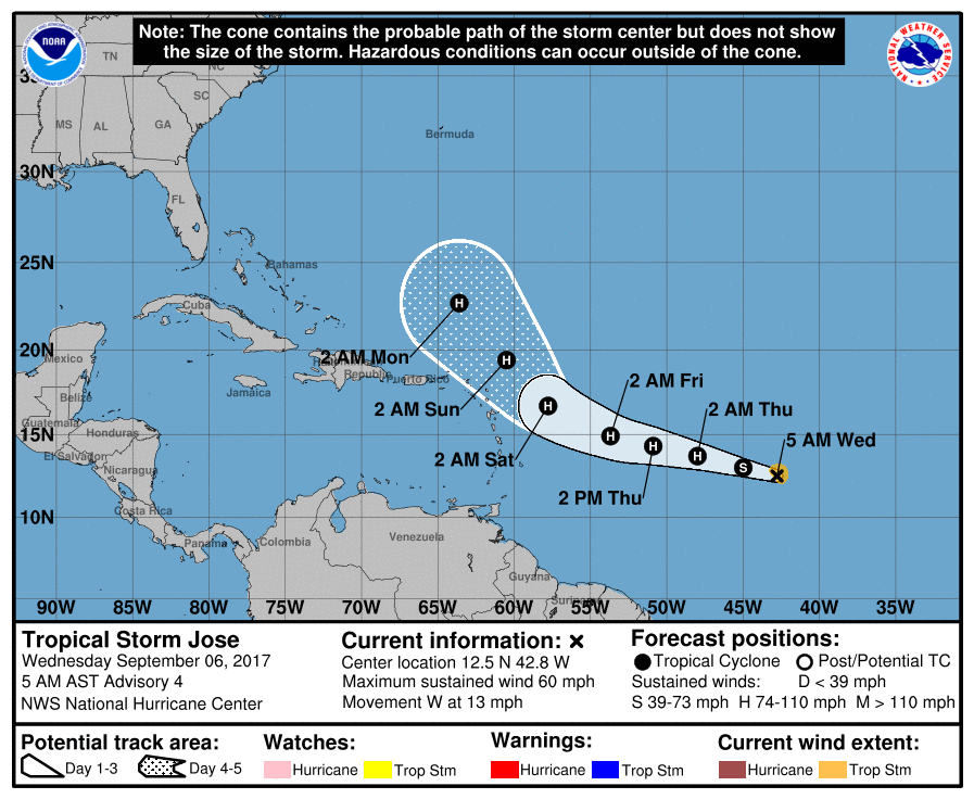 Tropical Storm Katia - This has formed in the Bay of Campeche in the Gulf. This storm will drift into Mexico during the next 3-5 days with no impacts on Texas or the US. See the Texas Weather Discussion Video for more details. 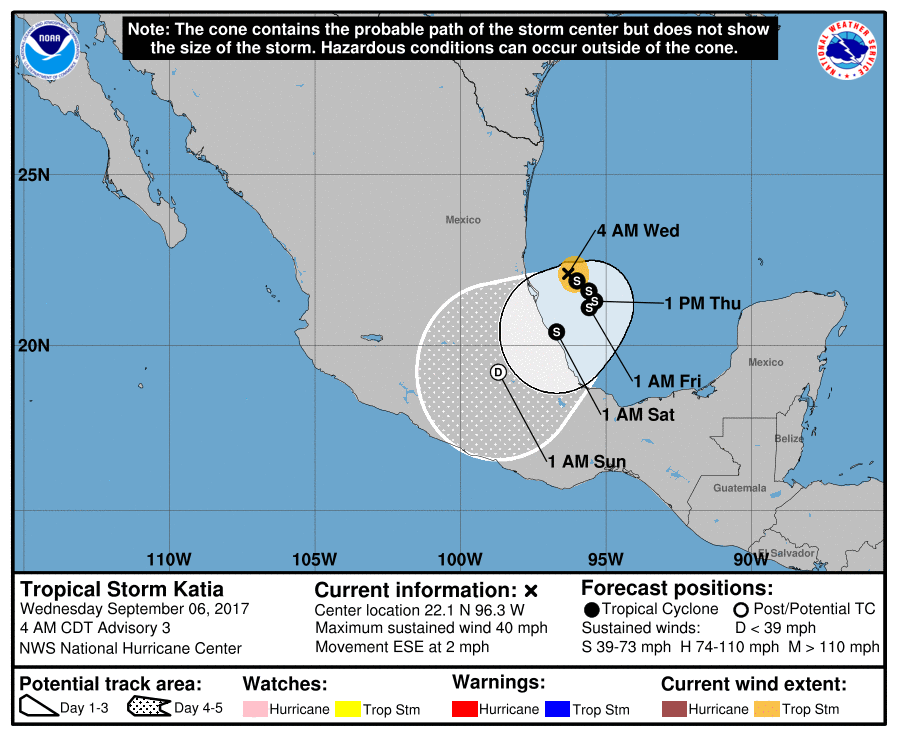 Today most locations start the day off with highs in the low to mid 70s for the morning commute, staying dry until the cold front comes through. Needless to say, most of this post will be about Hurri When the cold front comes through, we will notice a temperature difference (which won't come until tomorrow) and will mention a chance for afternoon/evening showers and storms. Though most locations will ultimately end up staying dry, the chances of one spot getting wet is in the 20-40 percent bracket. The Rest of the Week - We should ultimately trend cooler in drier air, which is a great feel for early September. Highs will be in the mid to low 80s with lows reaching down into the 50s in some spots. With plenty of sunshine, we should continue to be in drier air for the latter half of the week. Friday and the Weekend - We will continue to feature dry weather with mostly sunny and pleasant days along with cool nights. Highs will continue to stick towards the mid 80s with lows in the 60s. Great weather for high school football games. Next Week - Not much change. We will continue to have sunny, pleasant days with highs in the mid to upper 80s, which is a good thing for early September.  DANGEORUS HURRICANE IRM - Irma is continuing to head towards the Leeward Islands. As I am writing this, Irma strengthens to a dangerous CATEGORY FIVE HURRICANE WITH MAXIMUM SUSTAINED WINDS OF 175 MPH. The central pressure is down to 929 mb (millibars). A Hurricane Warning is in effect for… * Antigua, Barbuda, Anguilla, Montserrat, St. Kitts, and Nevis * Saba, St. Eustatius, and Sint Maarten * Saint Martin and Saint Barthelemy * British Virgin Islands * U.S. Virgin Islands * Puerto Rico, Vieques, and Culebra 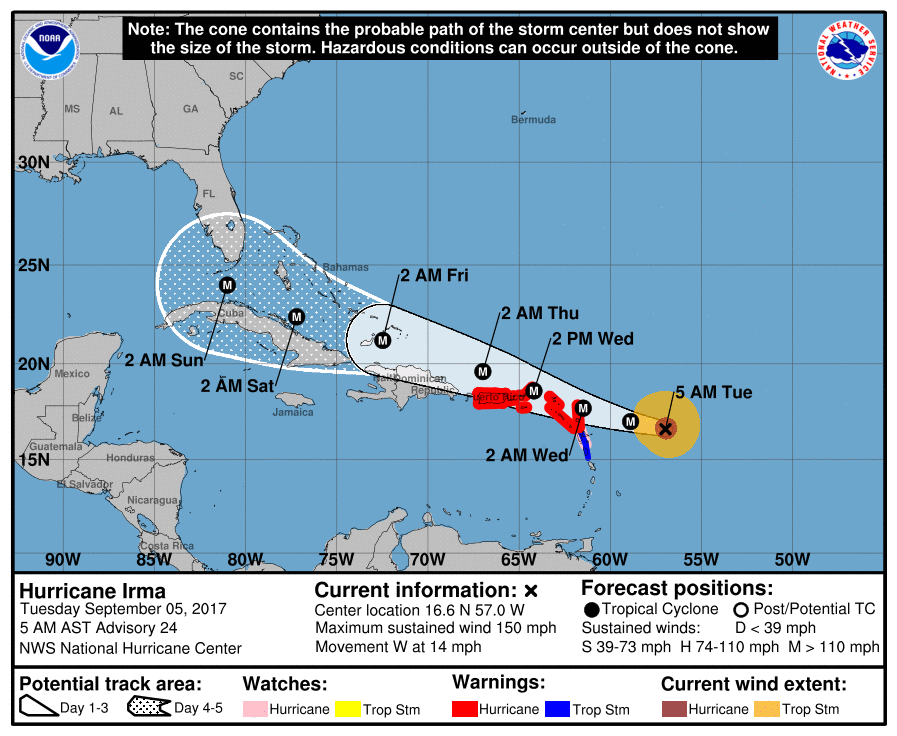 Here are some important things to mention as we ride through this...
*Do not focus on the exact forecast forecast track, especially at the longer ranges, since the average NHC track errors are about 175 and 225 statute miles at days 4 and 5, respectively. *Irma is expected to make a hard right turn over the weekend in response to a deep upper trough over the eastern half of the U.S. Exactly when that turn happens will determine the ultimate impact on the Florida Peninsula. * Unfortunately, both primary global models (the American GFS and the European ECMWF) show the core of Irma moving northward, through the spine of the Florida Peninsula, in the Sunday/Monday time frame. This, of course, could change, but there is excellent model agreement in this idea. *People in the Florida Peninsula need to continue preparations for a major hurricane, and listen carefully to statements from local governments later this week as some evacuation orders will most likely be needed. Tropical storm force winds could reach South Florida as early as Friday night. *It is unlikely that Irma enters the Gulf of Mexico. For now, we expect little, if any impact on places like Gulf Shores, Pensacola, Navarre Beach, and Destin. Panama City Beach could see some wind and rain Sunday or Monday, but they will be on the “good”, drier side of the hurricane most likely. *Always use fresh, updated weather information. With any tropical system forecast changes are very possible, if not likely, as it goes closer to land and the prime U.S. upper air network. Thankfully both USAF and NOAA aircraft are collecting data this morning; this goes into the computer models we use to make them more reliable. The Rest of the Tropics - There is a wave in the western Gulf of Mexico that may show some slow development signs, but should not affect the US due to the cold front that will move south. There is another wave trailing Irma that may become Tropical Storm Jose in the next 3 to 5 days. See the Texas Weather Discussion Video for more details. Air You Can Wear - Nearly everyone in North Texas starts the day dry with temperatures in the 60s, some in the upper 50s, which is a nice start to the first day of Meteorological Fall! We will most likely warm to the very low 90s today with plenty of sunshine and little to no precipitation chances, which is a great day for high school football. This evening, Mansfield High School will take on Summit High School at Vernon Newsom Stadium. Kickoff begins at around 7:30. By that time, the sun should be going down with highs remaining between 84 and 87. Labor Day Weekend - Things should continue to be nice and pleasant with highs in the low 90s with sunshine in full force on Saturday. During the overnight hours between Saturday and Sunday, moisture values will begin to increase, as well as the chance of scattered showers and storms during the night. A few spotty showers will still be possible during the day on Sunday. The best chance of one spot getting wet is in the 20-40 percent range. Most areas in North Texas will continue to stay dry this Labor Day weekend. Next Week - By Tuesday and Wednesday, a cold front will continue to move south, which will create more chances for evening/overnight scattered showers and storms and will also drop the temperature down to the low 80s. After that, the rest of the week should be pleasant with sunshine back in full force on Thursday.  Harvey - Harvey is basically no more! The remnants of Harvey is in the southeast, but the main risk shifts from a flooding threat to more of an isolated tornado risk. Harvey should become post-tropical cyclone by this weekend. Irma - Within the past 24 hours, Harvey has gone from a tropical storm to a major hurricane. I will say that I have not seen that from a hurricane thus far. The GFS (Global Forecasting System) shows Irma coming very close to the East Coast. But the more reliable European model shows the hurricane affecting Cuba. The main point is that we currently do not know where this hurricane will go, and we won't know that for the next 4-5 days.  There is another wave emerging from the African coast that has a 50/50 chance of developing during the next five days. It is too early to tell the intensity of this disturbance, or where it will go, but if it becomes a tropical storm, its name will be 'Jose'. See the Texas Weather Discussion Video for more details. 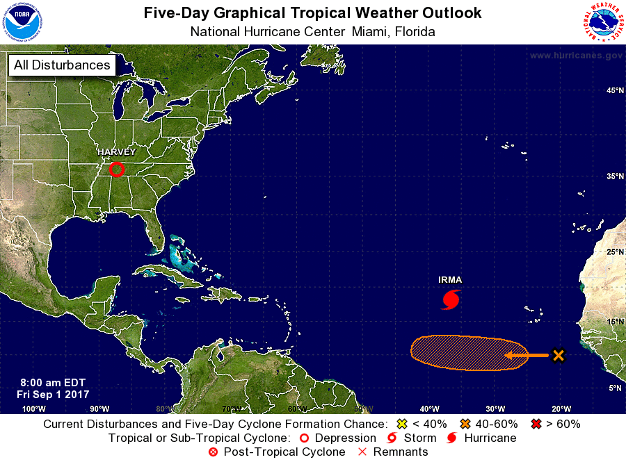 |
Archives
April 2024
Categories |
 RSS Feed