
|
*no Texas Weather Discussion Video today* VERY COOL MORNING - A long-awaited cold front swept the region yesterday morning, which brought numerous scattered showers and storms across the region and cooler temperatures. Although that front is down to the south now, we are still feeling it with cooler weather. Temperatures are in the low 60s across the region. The last time we have seen morning lows in the low 60s was in April/May. We will maintain our cooler weather with afternoon highs in the mid 70s, about ten degrees cooler than our average high of 85° for September 27. FRIDAY AND THE WEEKEND - Confidence is increasing that most of the weekend trends much drier. We are forecasting mostly sunny days, fair nights, and only a few isolated showers. Highs will be in the 82-86 degree range with morning lows in the upper 70s. MIDLOTHIAN MARCHING CONTEST - The Midlothian Marching Showcase will be held at the Midlothian ISD Multi-Purpose Stadium this Saturday. Expect a fair amount of cloud cover with any scattered showers to the south of the metro. The good news is, since the air is cool and stable, you won't be sweating as much after prelims/finals run. I will have graphics for all of the upcoming marching contests happening this Saturday tomorrow. FOOTBALL WEATHER - For the high school football games Friday night, the sky will be partly cloudy with temperatures falling through the low 80s. Showers and thunderstorms should not be an issue. NEXT WEEK - The upper ridge begins to rebuild across the South, and we will maintain our warm, dry pattern with partly cloudy skies. Highs will stick in the low to mid 80s. 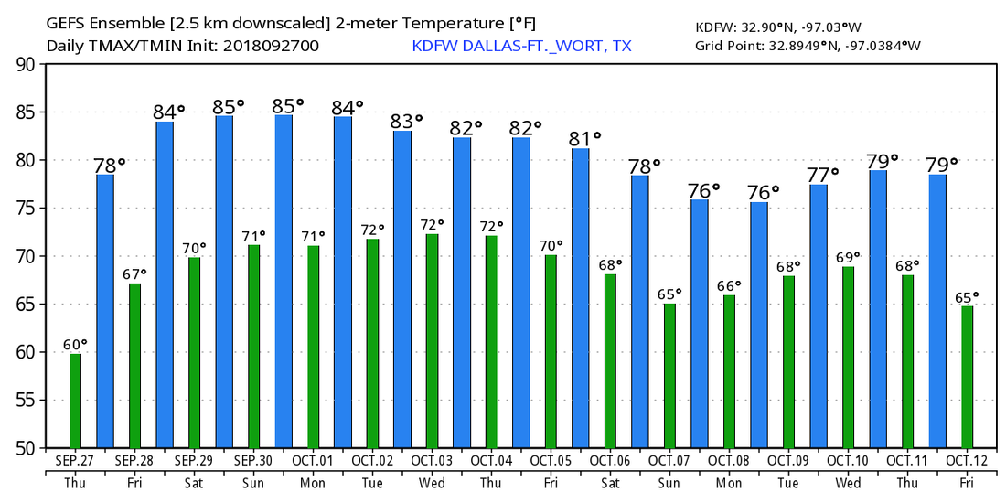 TROPICS - Tropical Storm Kirk will move through the Lesser Antilles this morning with sustained 60 mph winds. After that, weakening is expected once the system reaches the Caribbean, and there is a good chance that this system dissipates south of the Dominican Republic this weekend as a result of dry air and shear. The rest of the Atlantic Basin is quiet. 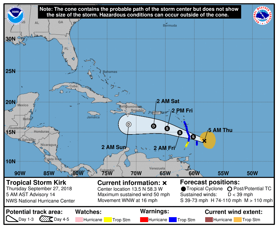 RADAR CHECK - With the strong cold front coming through, scattered showers and thunderstorms are occuring over parts of North Texas this morning.  Some of these storms are producing heavy rain, frequent lightning, and gusty winds. These will become more widespread in coverage as we progress through the morning, eventually dissipating as we get into the late afternoon hours.
As a result of the strong cold front, temperatures will go the wrong way today. We are currently in the middle 70s right now. We will fall to the middle to upper 60s by the afternoon; a 30° difference from yesterday's high. The cold front moves to the south tomorrow, and we will maintain a dry, cool forecast with highs in the mid 70s and morning lows in the mid 60s with a mix of sun and clouds. FRIDAY AND THE WEEKEND - Global models have trended much drier for the three days, and we will mention the chance of only isolated showers on Sunday with a mix of sun and clouds on all three days. Highs will be in the low 80s. NEXT WEEK - Next week for the most part looks fairly dry, though we will still mention a small chance of an isolated shower or two during the early parts of next week. Highs will mostly be in the low 80s. The GFS continues to show the idea of a long wave upper trough over the eastern third of the country, which would have the potential of bringing cooler temperatures down south. Will continue to monitor trends. See the Texas Weather Discussion Video for more details. TROPICS - Kirk regenerated into a tropical storm late last night. It is continuing to move east towards the Lesser Antillies. It will eventually end up in the Caribbean as a tropical depression, becoming post-tropical by Sunday. All of the other waves in the Atlantic only have a low chance of regeneration. There is nothing expected to impact the Gulf of Mexico at this present time. *no Texas Weather Discussion Video due to micing issue* Most of the area is dry early this morning. We will forecast a mix of sun and clouds today with afternoon highs in the low 90s. This should be our last 90° day for a while as a very strong cold front pushes through the area tomorrow morning. REST OF THE WEEK - A strong cold front pushes through North Texas tomorrow during the early morning hours, bringing prolonged cooler temperatures and more rain chances in the long-term. We will forecast at least occasional showers and thunderstorms tomorrow, though it will not be a complete washout by any means. The best chance of any one spot getting wet is in the 40 percent bracket. It won't be completely cloudy as we will have breaks from the clouds throughout the week for the areas that don't see rain. The front dissipates on Thursday, so we will stick with a dry forecast that day. Highs for the rest of the week will be in the middle to upper 70s tomorrow and Thursday due to rain and clouds, warming to the low 80s by Friday. Rain amounts between now and the weekend will mostly stay in the half-inch category with some places seeing more. Keep in mind that this will NOT be a washout, nothing like we saw this past weekend where DFW set a record for the most rain recorded in 24 hours. THE WEEKEND - Seems like we will experience a mix of sun and clouds on both days with potential for scattered showers and thunderstorms, mainly during the afternoon hours. The chance of one spot getting wet is in the 20/30 percent range, and highs will remain in the mid 80s. NEXT WEEK - Not much change. We are keeping a close eye on the mid-latitude westerlies in the north that could finally beat down the ridge in the south and Central U.S. once and for all towards the end of next week.  TROPICS - What used to be Tropical Depression Kirk is just an open wave in the Atlantic, there is some chance that it tries to redevelop over the coming days as it gets closer to the Lesser Antilles. Subtropical Depression Leslie will become post-tropical by tomorrow. The remnants of Florence is still hanging around near the U.S. East Coast; if it wants to try to redevelop again, it should remain offshore. There are no tropical cyclone threatening the Gulf of Mexico or the U.S. at this time.
FAIRLY DRY MORNING - Not much to see on the radar this morning, but we do have a few areas of patchy drizzle as you head to work and school this morning. A few showers here and there can't be ruled out throughout the day as it will stay mostly overcast today, but the chance of any one spot getting wet is only in the 20 percent bracket. Highs will stay in the low 80s today. The sun might try to come out at times. Then tomorrow, we dry out with a mix of sun and clouds this time. We could see our very last push to 90° for a very long time. Most places will stay in the 80s. WEDNESDAY THROUGH FRIDAY - The long awaited cold front makes its appearance early Wednesday morning, bringing cooler temperatures and more frequent rain chances to the area. It will also bring more scattered shower and thunderstorm chances on Wednesday; the best chance of one spot getting wet is 50/50 at this point. Temperatures will be in the mid 60s in the morning, only rising to the low 80s by the afternoon. Thursday will be mostly cloudy with highs in the low 80s with a few showers in the afternoon, then we introduce at least a slight chance of showers on Friday before the weekend. Like before, it won't rain all day, and afternoon highs will stay in the lower 80s. THE WEEKEND - We will maintain a fairly consistent chance of a few scattered showers through the weekend with mostly a mix of sun and clouds on both days. Highs will be in the lower 80s for the weekend. NEXT WEEK - Any showers or thunderstorms will be confined to a minimum next week for now. We will continue to mention a mix of sun and clouds each day with highs in the low 80s for at least the early part of next week. See the Texas Weather Discussion Video for more details.  TROPICS - Tropical Depression Kirk is located in the Southern Atlantic with maximum sustained winds of 35 mph. It will continue to move west towards the Lesser Antilles as a low-end tropical storm. Subtropical Storm Leslie is further north, also hanging on as a subtropical storm. It will become post-tropical tomorrow morning with no impact to land. And, invest 98L is located near the East Coast again, and is not expected to develop due to strong upper level winds. It will ultimately curve out to sea to the north, staying away from any land masses. The rest of the Atlantic Basin is quiet. 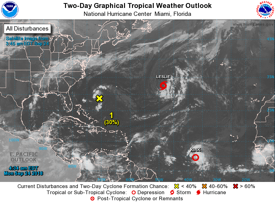 *no Texas Weather Discussion Video this morning* RADAR CHECK - Isolated showers and thunderstorms are about in North Texas this morning with temperatures mostly resting in the middle 70s. The good news is we won't warm much this afternoon with temperatures only reaching the mid 80s.  We will also increase the chance of widespread scattered showers and thunderstorms as a surface front interacts with deep moisture. Expect things to get wet starting late morning into the afternoon hours. Rainfall amounts of around 5-6 inches is expected through the weekend, and a Flash Flood Watch is in effect for parts of the North Texas area from this morning through Saturday Evening, but will likely be extended into Sunday and even early portions of next week. The best coverage of widespread showers and thunderstorms will begin this evening, lasting through Friday night and through Saturday morning. 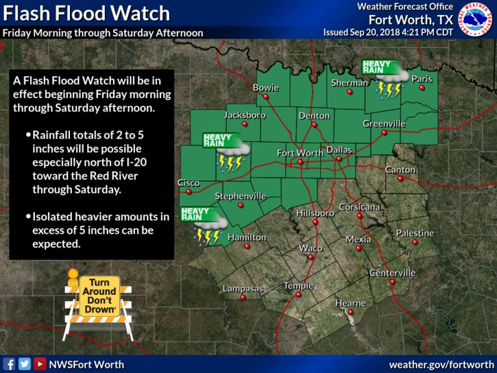 Saturday will just be a wet, muggy day with heavy rain and thunderstorms likely. Temperatures will hold in the upper 70s due to rain cooled air with mostly cloudy skies. Then, we will continue to mention the chance of scattered thunderstorms on Sunday as our surface front starts to move east. The highest chance of one spot getting wet is in the 50/50 percent range. Like Saturday, highs will stick into the upper 70s. NEXT WEEK - It sure looks like most of next week will be mostly cloudy with occasional scattered showers at times as the air remains moist and unstable, and the much anticipated front gets closer. The highest coverage of rain looks to come Tuesday and Thursday, then just a risk of a few passing showers on Friday as the much anticipated front arrives. For next weekend, it is becoming clear that we will see a mix of sun and clouds with highs in the upper 70s and morning lows in the upper 50s. A couple of naturally cooler spots have a chance of seeing mid 50s... 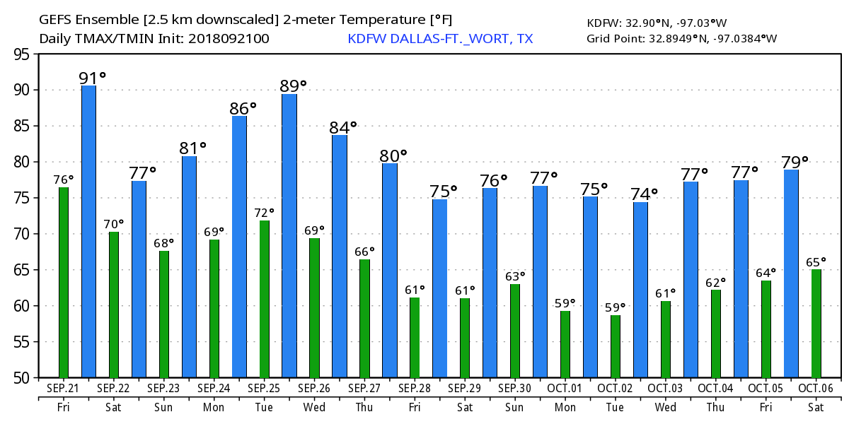 TROPICS - A disturbance in the Central Atlantic has a 70 percent chance of developing within the next five days. There is also another wave off of the coast of Africa that could show development this weekend. The other waves show very little signs of development. 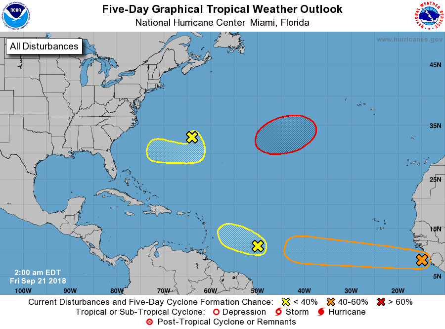 *no Texas Weather Discussion Video this morning* STILL HOT - We project a high around 93° this afternoon, which is still hot for late September. The sky will be sunny for the most part, and the subsidence under the upper high has put a lid on showers and thunderstorms for most of the state over the past week. Even today, we might only see isolated storms. FRIDAY AND THE WEEKEND - The upper high will weaken as a surface front pushes through the area. Rising moisture levels will also bring widespread chances of scattered showers and thunderstorms beginning Friday and for the rest of the weekend. Chance of any one spot getting wet will be in the 70/80 percent range all weekend long. Otherwise, mostly cloudy days with cool nights, and highs mostly in the low to mid 80s. NEXT WEEK - We will still maintain at least a slight chance of scattered showers and thunderstorms through a good part of next week as a long awaited cold front moves north with the support of a deep upper trough. Much cooler air should invade North Texas by Thursday with highs in the upper 70s and lows in the mid 50s... 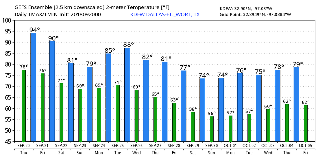 TROPICS - The Atlantic Basin is very quiet, and no new tropical cyclones are expected through the weekend.
ON THIS DAY ONE YEAR AGO - Hurricane Maria reached Category Five strength and made landfall on Dominica, becoming the first Category Five hurricane on record to strike the island. After weakening slightly due to crossing over land, Maria achieved its peak intensity over the eastern Caribbean with max. sustained winds of 175 mph and a pressure of 908 mb, making it the 10th most intense Atlantic hurricane on record. HOT SEPTEMBER WEATHER - Temperatures are starting off in the low to mid 70s to start off our Wednesday morning. The sky will be mostly sunny with a few clouds, with highs in the 92-97 degree range this afternoon. Not much change in the weather conditions tomorrow... Hot and mostly dry are the main words. However, moisture will slowly increase throughout the day as a surface front approaches the area, so we will mention slightly higher cloud cover with a few afternoon showers and thunderstorms. Highs will be in the low 90s. FRIDAY AND THE WEEKEND - The surface front gets even closer to North Texas, so we will continue to maintain the chance of scattered to numerous showers and thunderstorms during the afternoon and evening hours on Friday as moisture levels continue to rise. A lot of high school football games occur Friday evening, so expect delays and even cancellations across the North Texas area. Odds of one spot getting wet Friday afternoon and evening will be around 60/70 percent. Then, the surface front stalls Saturday and Sunday, which means most of the day will likely be wet with widespread showers and thunderstorms as moisture levels continue to remain high. The chance of one spot getting wet is in the 90 percent category on Saturday, and 50 percent on Sunday (which may increase over time). Rain amounts of around 2 to 3 inches or greater can be expected over the next few days. Highs will be in the upper 80s on Friday, falling into the low 80s for the weekend. NEXT WEEK - Moisture tries to stick around in the wake of a stalling surface front during the weekend, so we will need to mention the chance of at least isolated showers and thunderstorms during the early half of next week. Then, a few global models wants to push a surface front down with an upper trough to the north. This would mean the latter half of next week would also be fairly wet, but we will maintain a dry forecast until confidence increases. An upper trough is expected to dig into our Central third of the nation by the end of the week, which will give us better rain chances, and much cooler air by the 7-10 day time frame. See the Texas Weather Discussion Video for more details. 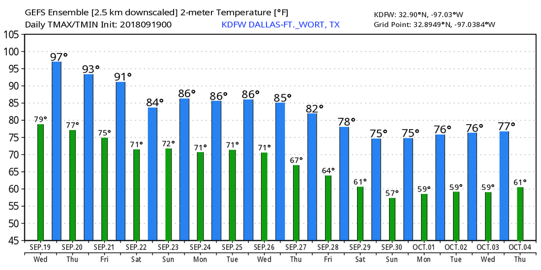 TROPICS - There is a wave in the Southern Atlantic that is disorganized. The NHC only gives it a 10 percent chance of development due to strong upper-level winds. The rest of the Atlantic Basin is quiet.
ON THE RADAR - Just like the past few days, the radar is very quiet this morning. We do note that there is still at least a slim chance of a pop-up isolated storm during the afternoon and evening. Most communities will stay dry today with highs in the low to middle 90s. REST OF THE WEEK - Not much change tomorrow or Thursday. Mostly sunny and very warm with a few clouds on Thursday with highs hovering around 90°. Forecast models are indicating a deeper moisture field on Friday with a three-day bump in the coverage of scattered showers and thunderstorms. It won't rain everywhere on Friday, and the chance of one spot getting wet is in the 50/50 percent bracket. Highs will be in the mid 80s on Friday. THE WEEKEND - Models are indicating an even deeper moisture field for the weekend with statewide coverage of scattered showers and thunderstorms Saturday. Chance of one spot getting wet is still 50/50, but that chance will definitely adjust within the coming days. Rain still lingers on Sunday, with a 30 percent chance of any one spot getting wet. Highs will only be in the middle 80s due to rain cooled air with mostly cloudy skies. NEXT WEEK - An upper trough in the northwest will finally start to break down the ridge next week, which means cooler temperatures more chances of isolated showers during the afternoon. Highs will still stay in the mid 80s for the early parts of next week, trending cooler as we go on. We are still projecting our next big pattern change to be towards the end of September/beginning of October in about 10 days, which will do a good job of bringing much cooler air down to north Texas. 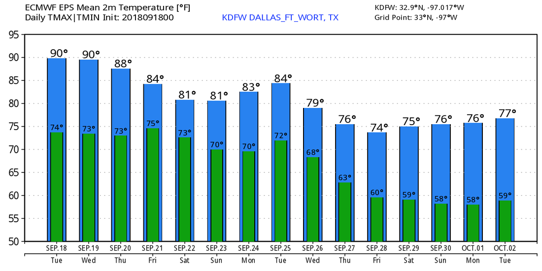 TROPICS - There are no tropical cyclones in the Atlantic Basin this morning. The remnants of Isaac in the Caribbean is not expected to develop at all. Tropical Depression Joyce will become post-tropical early tomorrow morning. Post-Tropical Cyclone Florence were still causing problems yesterday afternoon. Several tornado warnings were issued, with a large tornado passing through Richmond, VA with multiple injuries and even a death reported.  Photo from Michael A. Sizemore.
DRY MORNING - Temperatures are in the low 70s this morning... We continue to project afternoon highs in the lower 90s with a mostly sunny sky. An isolated shower or thunderstorm can't be ruled out during the afternoon hours, but the chance of one spot getting wet is only in the 10-20 percent category. REST OF THE WEEK - The weather for this week remains fairly tranquil and dry with hot and sunny conditions. Highs for Tuesday through Thursday will be in the low 90s with abundant sunshine. A surface front approaches the area on Friday, and tropical moisture begins to advect to the north at the same time. We will forecast scattered showers and thunderstorms for now with a mix of sun and clouds. The high on Friday will be in the middle 80s. The chance of one spot getting wet is only in the 30 percent category for now. THE WEEKEND - Our next best chance of rain could potentially arrive Saturday as the surface front and tropical moisture clashes. We don't expect a full-blown washout, though, as rain amounts will likely stay under the one inch range. The best chance of one spot getting wet is only in the 30-40 percent range for now, and the sky will be sunny with a few clouds. Highs for the weekend will be in the middle 80s with a decrease in rain coverage on Sunday. NEXT WEEK - We could see at least a few showers or thunderstorms during the afternoon on Monday, but it looks like the early part of next week stays dry with highs in the middle 80s. Then, beyond that point, it look like we start to get a true taste of fall weather with highs dropping to the low 80s with lows in the 60s. See the Texas Weather Discussion Video for more details. 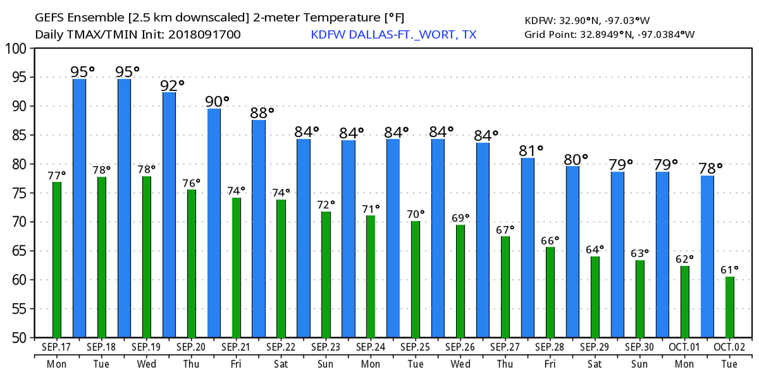 TROPICS - We only have two named storms in the Atlantic Basin currently - Florence and Joyce. Florence is finally moving to the northeast after dumping heavy rain over the Carolinas for days due to no steering currents. The only threat from this system at this point is heavy rain and small and only a couple of isolated tornadoes. It will continue to move to the northeast this week as it concludes its life cycle. Joyce is still in the Northeastern Atlantic hanging on as a Tropical Depression. It is expected to turn southward and become post-tropical by Wednesday, if it even survives for that long. No threat to any land. And, we have the ghost of Beryl out in the Caribbean Sea battling lots of dry air and shear. More than likely this will continue to not develop and move to the northwest towards the Northern Caribbean. The rest of the Atlantic Basin remains quiet. 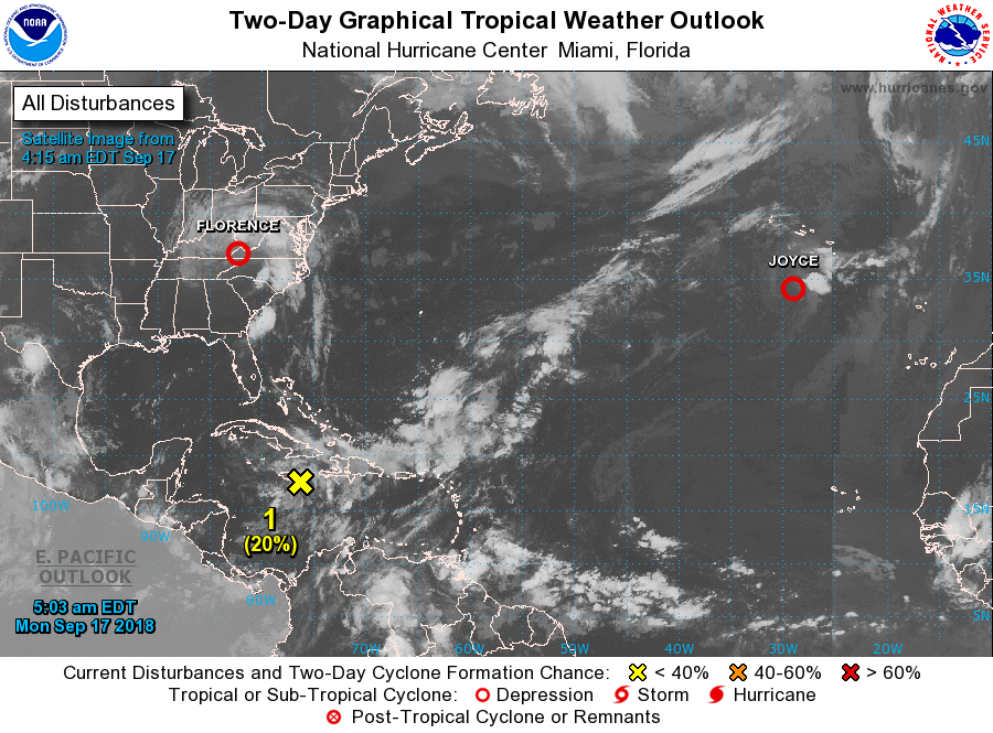 *no Texas Weather Discussion Video today* DRY MORNING - All of the North Texas region remains dry this morning, something we have not seen for the past few days. We will maintain the chance of afternoon showers since we are still in a fairly moist airmass. The chance of one spot getting wet this afternoon will be in the 20 percent bracket. Otherwise, expect a mix of sun and clouds with highs in the upper 80s. Then, tomorrow through the weekend, we expect mostly a mix of sun and clouds with isolated, afternoon showers and thunderstorms. Highs will be around 90°, and any afternoon showers will be very limited in coverage. NEXT WEEK - The big rains from Invest 95L in the Gulf will stay mostly over southern Texas and the coast. Each day will feature partly to mostly sunny skies with highs mostly in the upper 80s. FLORENCE APPROACHING THE COAST - Hurricane Florence continues to approach the coastline with maximum sustained winds of 110 mph, near Cape Fear this morning. 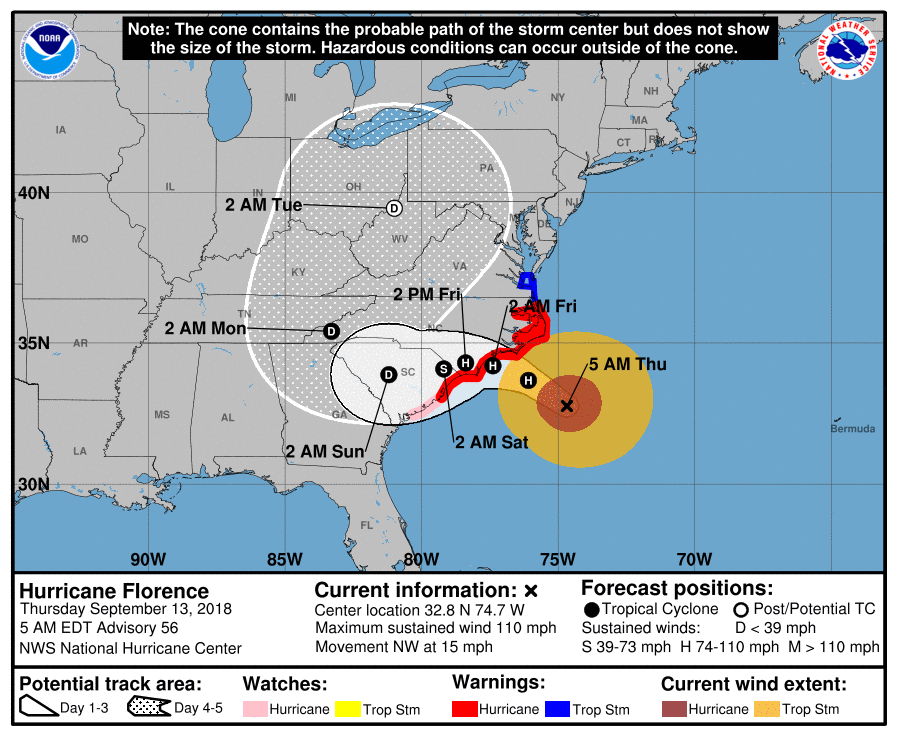 Florence is still a category two storm, and will likely maintain that strength at landfall. However, it is critical to know that the main impacts from this hurricane will come from flooding and life-threatening storm surge. From the National Hurricane Center, here are the key messages: 1. A life-threatening storm surge is now highly likely along portions of the coastlines of South Carolina and North Carolina, and a Storm Surge Warning is in effect for a portion of this area. All interests in these areas should complete preparations and follow any advice given by local officials. 2. Life-threatening, catastrophic flash flooding and prolonged significant river flooding are likely over portions of the Carolinas and the southern and central Appalachians late this week into early next week, as Florence is expected to slow down as it approaches the coast and moves inland. 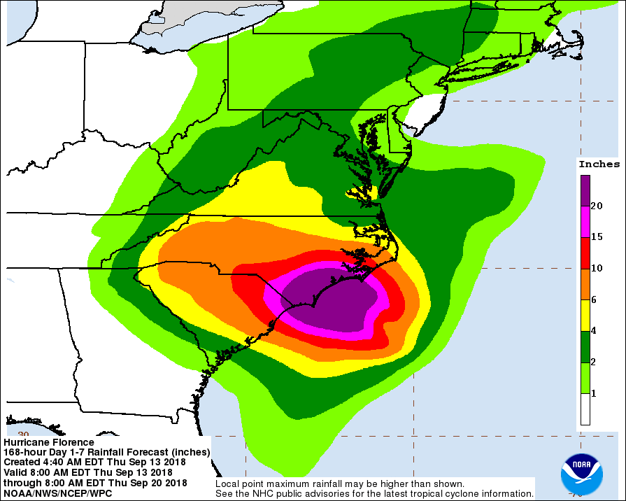 3. Damaging Hurricane-force winds are likely along the coast of the Carolinas, and a Hurricane Warning is in effect. Strong winds could also spread inland into the Carolinas. 4. Large swells affecting the Bermuda, portions of the U.S. East Coast, and northwestern and Central Bahamas will continue this week, resulting in life threatening sea and rip currents. ISAAC - This tropical storm will move through the Leeward Islands today, then continue west towards the Caribbean Sunday if it survives. It is a low-end tropical storm with sustained winds of 45 mph. 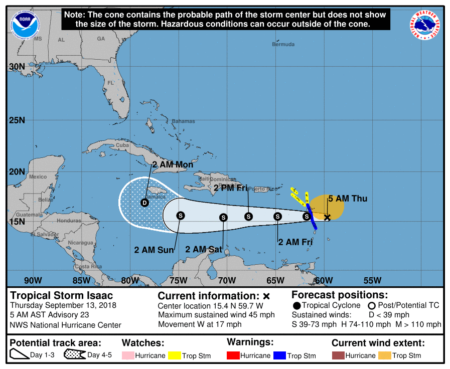 In other news, Subtropcial Storm Joyce and Hurricane Helene are in the North Atlantic, far away from the U.S.
RADAR UPDATE - There is a cluster of isolated showers along and south of I-30 this morning, slowly moving to the north. A few other showers and rumbles of thunder are present near Meridian, mainly to the west of I-35. All of these showers will continue through most of the day, but should not be a widespread rain event. TOMORROW THROUGH THE WEEKEND - Our weather will remain the same for the rest of the workweek through the weekend; mostly cloudy with a few instances of clouds along with the chance of isolated showers during the morning, becoming more scattered by the afternoon as the tropical atmosphere continues. Afternoon highs will be in the mid 80s through Friday, warming slightly to the upper 80s by the end of the weekend. NEXT WEEK - Confidence is starting to increase that a good part of next week will continue to remain dry with a mix of sun and clouds on most days. The upper ridge over the Central U.S. holds, which means afternoon highs will still be in the low 90s. Remember, we usually don't see a good surge of cool air until we get into late September/early October. ALL EYES ON FLORENCE - Florence is still a dangerous Category Four Hurricane in the Atlantic with sustained winds of 130 mph. She is expected to intensify today as she moves into the warmest waters she has been in. While weakening is possible right before landfall, Florence is expected to still be a major hurricane while along the North Carolina Coast. The forecast track continues to shift to the south. Please note these changes in the forecast. 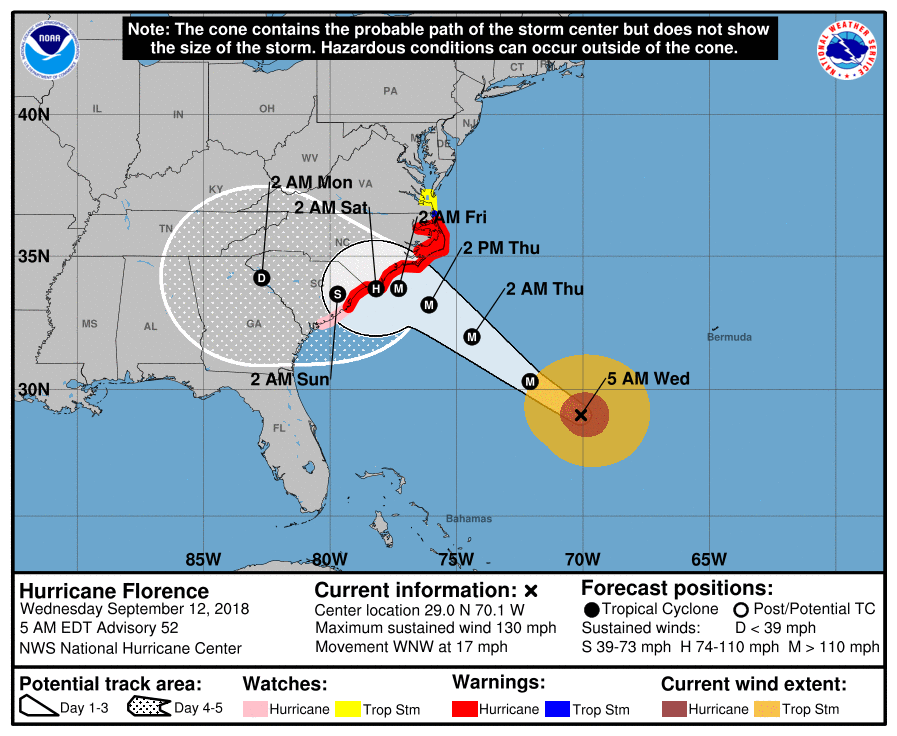 Here are the latest Key Messages... 1. A life-threatening storm surge is now highly likely along portions of the coastlines of South Carolina and North Carolina, and a Storm Surge Warning is in effect for a portion of this area. All interests from South Carolina into the mid-Atlantic region should complete preparations and follow any advice given by local officials. 2. Life-threatening, catastrophic flash flooding and significant river flooding is likely over portions of the Carolinas and Mid-Atlantic states from late this week into early next week, as Florence is expected to slow down as it approaches the coast and moves inland. 3. Damaging hurricane-force winds are likely along portions of the coasts of South Carolina and North Carolina, and a Hurricane Warning is in effect. Strong winds could also spread inland into portions of the Carolinas. 4. Large swells affecting Bermuda and portions of the U.S. East Coast will continue this week, resulting in life-threatening surf and rip currents. ISAAC - This is a tropical storm in the Southern Atlantic which is expected to move across the Leeward Islands tomorrow, then into the Caribbean. It remains to be seen if this impacts the Gulf of Mexico or any part of the U.S. at this present time. 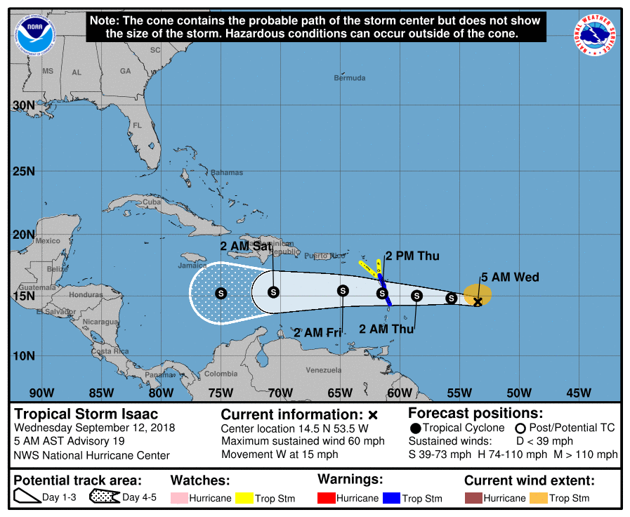 HELENE - Helene is a minimal hurricane in the Eastern Atlantic. It will contine it’s trajectory to the north, far away from the U.S.  Invest 95L is also emerging from the Bay of Campeche at this point. The NHC gives it a high chance of developing to a tropicam depression or Tropicam Storm Joyce. Regardless of strength, this will impact the Texas Coast near Corpus Christi, then continue to move to the west. North Texas stays dry from this system.
RADAR CHECK - Most of the showers this morning are located around and mainly to the west of Cleburne and to the east of Dallas. They will continue to move more to the north this morning, and more development is possible later in the day. Temperatures are only in the upper 60s this morning, and we should only warm to the upper 70s/low 80s this morning with mostly cloudy skies again. TOMORROW THROUGH FRIDAY - Scattered showers and thunderstorms will remain possible across the region through the latter half of the week, but not as scattered as last week or even today. Look for only partly sunny days with more clouds than sun Wednesday through Friday with only widely spaced showers; the chance of any one spot getting wet is only in the 20-30 percent range. Highs will be around 85° Wednesday, then closer to 90° Thursday and Friday. THE WEEKEND - Not much change. We will continue to mention the chance of a few showers during the afternoon hours with mostly cloudy skies. Afternoon highs will be in the upper 80s for both days. NEXT WEEK - Most of next week looks calm with a mix of sun and clouds each day. Highs will be in the low 90s to upper 80s to start out the week.  FLORENCE - Florence is now a category four hurricane with maximum sustained winds now at 140 mph. It is will moving to the northwest. Here are the latest Key Messages for Florence... • Life-threatening storm surge is expected along portions of the coast of South Carolina, North Carolina, and Virginia, and a Storm Surge Watch has been issued for portions of this area. All interest from South Carolina through the mid-Atlantic region should ensure they have their hurricane plan in place and follow any advice given by local officials. • Life-threatening freshwater flooding is likely from a prolonged and an exceptionally heavy rainfall event, which may extend inland over the Carolinas and Mid-Atlantic for hundreds of miles as Florence is expected to slow down as it approaches the coast and moves inland. • Damaging hurricane force winds are likely along portions of the coasts of South Carolina and North Carolina, and a hurricane watc has been issued for a portion of this area. Damaging wind gusts could spread well inland into portions of the Carolinas and Virginia. • Large swells affecting Bermuda and portions of the U.S. East Coast will continue this week, creating life threatening rip and sea currents. 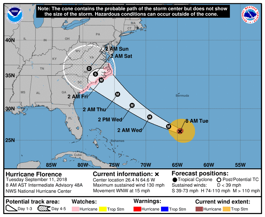 HELENE - Helene is a category two well in the south-central Atlantic. It is expected to gain latitude and turn northward, away from the U.S. 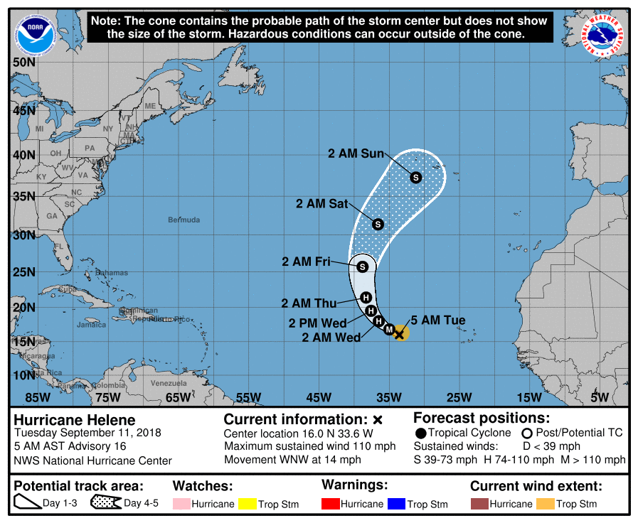 ISSAC - Isaac weakened to a tropical storm due to shear. It is expected to impact the Lesser Antilites as a tropical storm. It remains to be seen if this continues towards the bay of Campeche or turns towards the Florida Penisula. 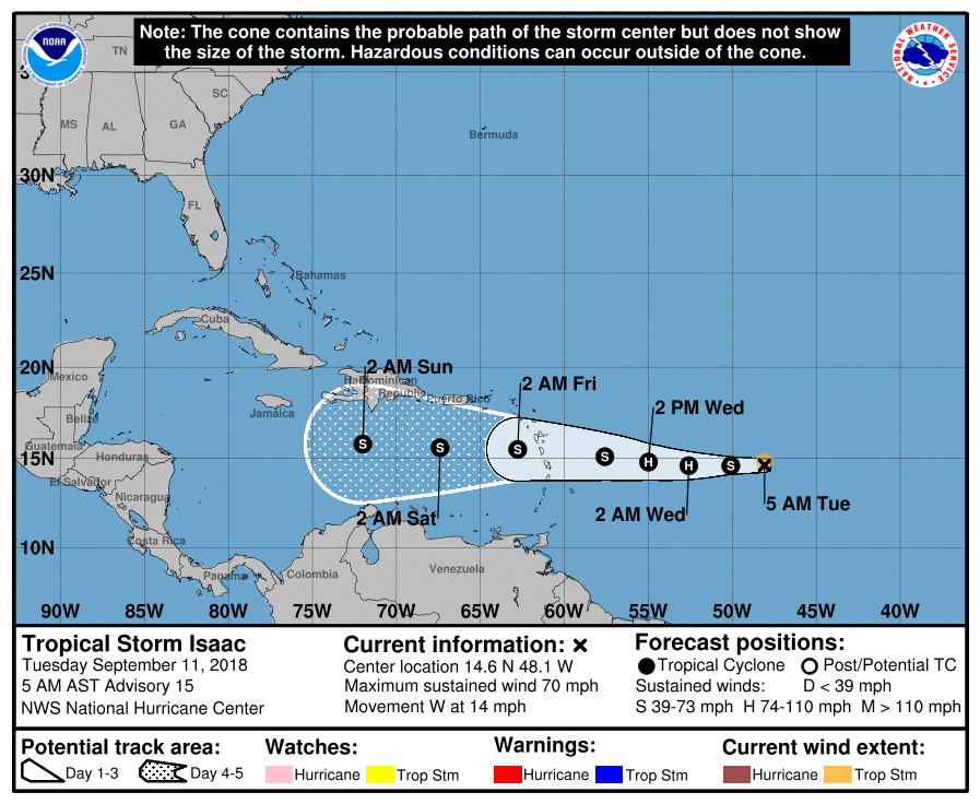 And we have invest 96L in the Gulf that has a 60% chances of becoming a tropical depression over he next five days. More than likely this impacts the Texas Coast in the form of heavy rain.
COOL MORNING - Temperatures are in the upper 60s across the board this morning, which is a clear indication that fall is here, given that we haven't seen lows this cool in quite some time. High cloud coverage will persist throughout the day in North Texas, and afternoon highs will struggle to get out of the 70s as a result. We can't rule out a passing shower or thunderstorm in a few places. We could see some scattered showers and thunderstorms tomorrow before the afternoon, mainly for areas near Dallas and to the east of I-35. Sunshine within breaks in the clouds is possible each day, but afternoon highs will still be in the low 80s tomorrow as we have a few thunderstorms near Dallas eastward. WEDNESDAY THROUGH FRIDAY - We start to see clouds start to clear out, so we will mention a mix of sun and clouds starting Wednesday and Thursday with afternoon highs warming up to the middle to upper 80s. Areal coverage of scattered showers and thunderstorms will increase Friday, but the best chance of one spot getting wet is only in the 30 percent category for now. Just like Wednesday and Thursday, highs will stay in the upper 80s. THE WEEKEND - We start to warm back to average temperatures for the weekend, with highs around 88-92° each day. Any showers and thunderstorms for the weekend will be confined to a minimum. A mix of sun and clouds is expected Saturday and Sunday. NEXT WEEK - It looks like most of next week will be filled with a mix of sun and clouds in the sky. Afternoon highs will continue to be in the upper 80s, still right about average for mid-September.  TROPICS - There are three active hurricanes in the Atlantic Basin; Issac, Helene, and Florence. The last time we had three hurricanes in the Atlantic Basin was last year when Irma, Jose, and Katia were still around. This is to be expected since we are in the climatological peak of hurricane season. 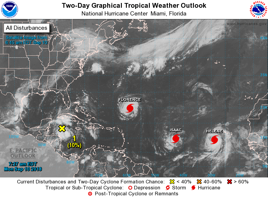 HELENE - Helene is a minimal hurricane just off of the African Coast with 80 mph sustained winds. The NHC anticipates this cyclone gaining latitude and moving north, away from the U.S. ISAAC - Isaac is another hurricane in the Atlantic which is moving due-west. It is expected to impact the Cabo Verde Islands as a minimal hurricane/high-end tropical storm. It remains to be seen if this moves towards the Gulf of Mexico or turns north out to sea. It’s way too far out. FLORENCE - Florence is still a high end category two hurricane with 105 max. sustained winds. This is expected to intensify to a major hurricane later today, further intensifying into a category four and maintaining its strength while landfalling near the Carolina Border. 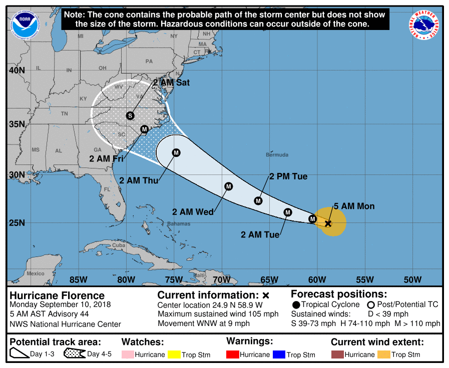 Hurricane Warnings and Watches will soon be issued for areas in and around the cone. Evacuations for the Carolinas and Virigina and other areas around the coast should begin today.
Another main impact from Florence will be heavy rain once this system landfalls and meanders over the region. This would mean some places would see about 1-3 feet of rain. It is imperative that you know the post-landfall effects of this system. See the Texas Weather Discussion Video for more details. RAINY DAYS - Moisture from Gordon will continue to linger around Texas today through the weekend along with a surface front coming through the region slowly. This will create our best chance of widespread showers and thunderstorms this week. The sky will be mostly cloudy today, and showers and thunderstorms are expected during the afternoon and evening hours. The chance of any one spot getting wet is 70/80 percent today. Scattered showers and thunderstorms will continue Saturday on the back side of the surface front as it slowly drifts to the east. It is safe to say that tomorrow will be more like today in terms of the expected coverage of rain and cloud cover. The high today and Saturday will only be in the middle 80s due to rain-cooled air. Rain tapers off to the east on Sunday, and we go back to a mix of sun and clouds with highs still in the 80s. FOOTBALL WEATHER - For the high school football games tonight, scattered showers and thunderstorms will still be in the area tonight. Due to the scattered/widespread coverage of the storms. It will be hard to predict who exactly gets wet this evening. But for those of you traveling to see the games, expect rain delays or even cancellations in some places. Temperatures will be in the low 80s by kickoff, falling into the mid 70s by the end of the first quarter. If you somehow remain dry this evening, it will definitely feel good outside. NEXT WEEK - We stay dry for most of next week with a mixture of sun and clouds each day. Highs will remain in the upper 80s to low 90s for most days. See the Texas Weather Discussion Video for more details.  TROPICS - The Atlantic Basin is quite active this morning. Florence weakened to a tropical storm yesterday evening and is now packing maximum sustained winds of 65 mph. However, conditions will favor intensification within the next several days, and will regain hurricane status over the weekend. It will become a Major Hurricane again next week to the southeast of Bermuda Islands. 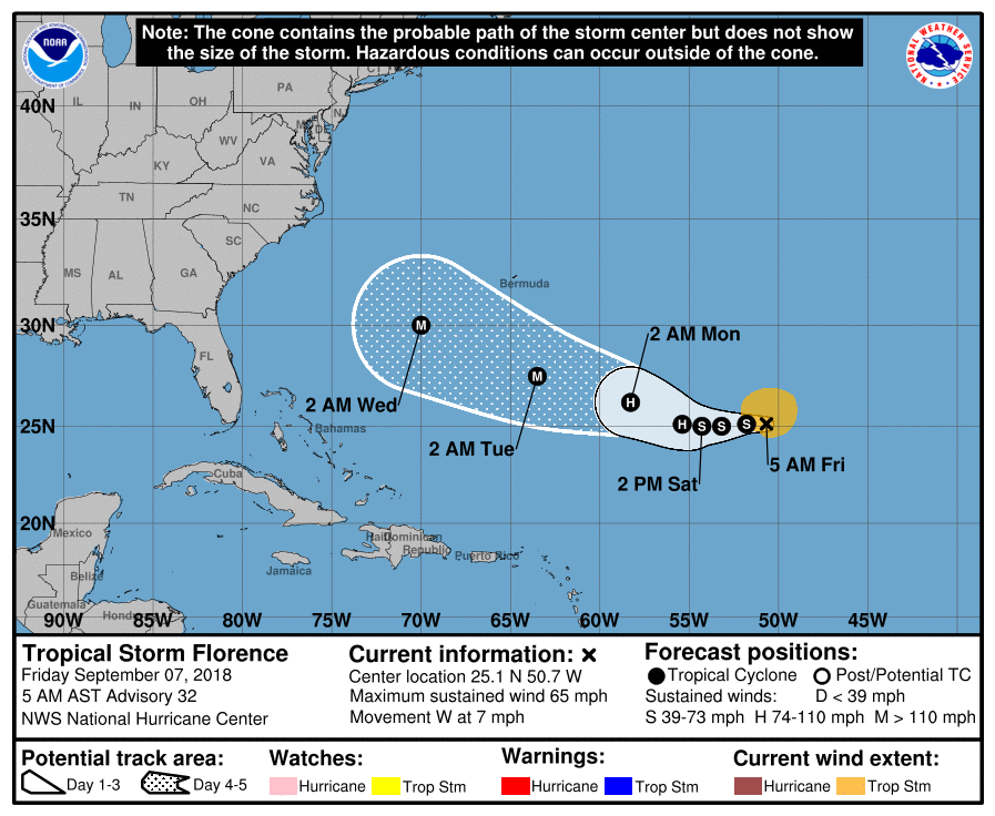 It could get extremely close to the U.S. East Coast during the later half of next week by sideswiping the coast, making landfall, or recurve just offshore - we don't know yet. There is no skill in a specific forecast track this far out, and it is impossible right now to forecast the exact impacts of Florence to the U.S. East Coast. The bottom line is, everyone on the U.S. East Coastal States should keep a very watchful eye on this system over the next several days. Back in the middle of nowhere, we have two well organized disturbances emerging off of the African Coast. They are expected to become Tropical Storms Helene and Isaac this weekend. There is absolutely no way in telling whether or not this will impact any land at this present time. 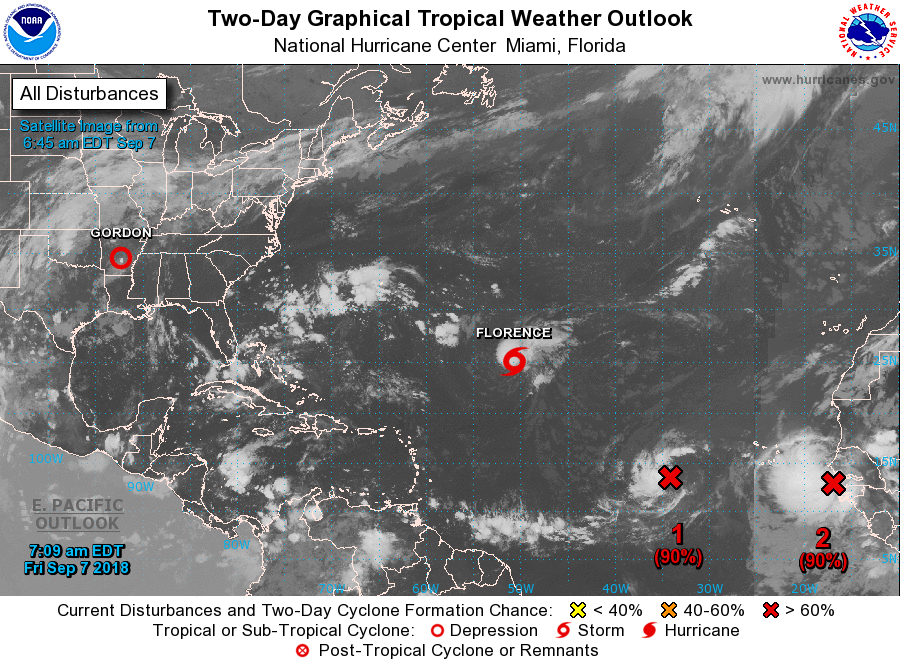 Tropical Depression Gordon made landfall last night at 10:11 PM with maximum sustained winds of 70 mph. It is now located near Jackson, Mississippi, with the spiral bands in Alabama at this point. For North Texas, we have a couple of morning showers to the west of the metroplex. They will continue to slowly move to the north/northeast. But for now, here is the latest information on Gordon... GORDON NOW A TROPICAL DEPRESSION - Gordon has weakened to a tropical depression moon this morning with maximum sustained winds of 35 mph. 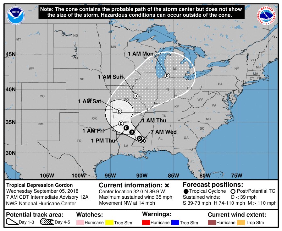 It will continue its trajectory to the northwest, mainly producing heavy rain and gusty winds near its forecast cone. The SPC maintains a marginal risk for severe storms for Central Mississippi and southwest Alabama to mainly address the potential for isolated tornadoes with Gordon.
TOMORROW - Our weather pattern continues to remain unsettled with lots of tropical moisture adverting to the north. Most of the day will be dry, but we will continue to mention the chance of isolated showers and storms during the afternoon. The best chance of any one spot getting wet is in the 30 percent range, and afternoon highs will be in the upper 80s. FRIDAY AND THE WEEKEND - As Gordon continues to slowly move to the northwest, it gets close to North Texas, and we will experience some more moisture advection, so we will see a greater chance of scattered showers and thunderstorms during the weekend. The best chance of one spot getting wet on Friday and the weekend is 50/50. Highs each day will be in the upper 80s with some sunshine. NEXT WEEK - There is good indication that a good chunk of the week will stay mostly dry with a mix of sun and clouds. Highs will be in the low 90s. See the Texas Weather Discussion Video for more details. TROPIX - Hurricane Florence is a powerful category two with max. sustained winds of 105 mph. It will continue to move to the northwest as a long-track hurricane. It remains to be seen whether or not this impacts the East Coast or kicks out to sea. There is also another wave off of the African Coast that has a 90% chance of developing into Tropical Storm Helene within the next five days. It is still far away from the US. GORDON - All eyes are on Tropical Storm Gordon in the Gulf as it is forecast to make landfall on the Central Gulf Coast as a category one hurricane tonight. CURRENT CONDITIONS - Gordon has maximum sustained winds of 65 mph this morning, and is moving northwest at 17 mph, 225 miles southeast of the mouth of Mississippi River. Tropical storm force winds extend way beyond the circulation center. This storm is expected to intensify into a hurricane later today, and should landfall on the Mississippi coast with max. sustained winds to around 75-80 mph, perhaps a tad greater in some places. 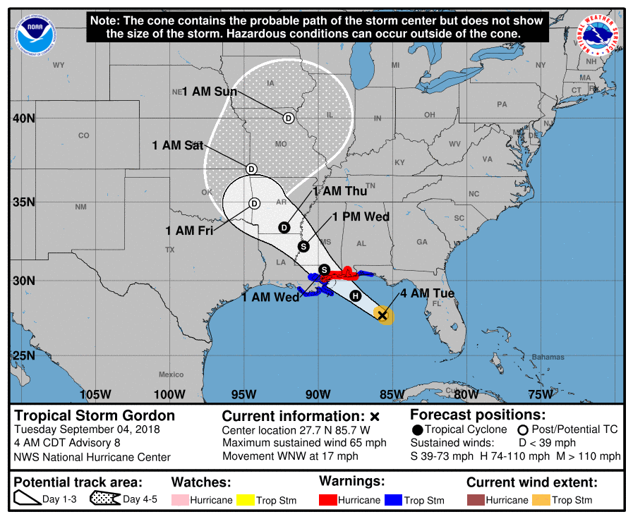 WARNINGS - A Hurricane Warning and Storm Surge Warning is in effect for the Central Gulf Coast. This storm is expected to bring hurricane-force winds and life-threatening storm surge to the coastal areas. Do not attempt to go near the waters. ON THE COAST - Weather conditions on the Gulf Coast will begin to deteriorate this afternoon and evening as Gordon steadily approaches. Here are the key notes... - Storm surge of around 3-5 feet is expected in the Central Gulf Coast during the peak impact of this system. - Rain amounts of 3-6 inches with localized amounts of 8 inches or greater is expected where the storm travels west/northwest. A flash flood watch covers much of Central Mississippi and adjacent areas/states near the Gulf Coast. - A few tornadoes and waterspouts are possible as Gordon approaches the land this afternoon and into tonight. SPC has defined the standard "slight risk" for the Alabama/extreme Florida Coastline, with a "marginal risk" for the Florida Panhandle, Southern Alabama and Mississippi. 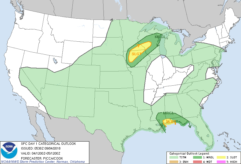 The weather over the Gulf Coast will improve significantly tomorrow afternoon, and the weather there will feature typical weather for early September with a mix of sun and clouds and risk of a passing shower or thunderstorm. NORTH TEXAS - We will most likely not see any impacts from this system as it continues its tragectory to the north/northeast once it reaches inland. The rain that we will see this week will mainly come from tropical moisture advection from the Gulf and frontal systems. Today should be mostly cloudy with scattered showers and thunderstorms about this afternoon and evening. The best chance of one spot getting wet today is 50/50, and the high wlll be in the middle 80s. REST OF THE WEEK - The risk for isolated to scattered showers and thunderstorms will remain possible for the rest of this week due to tropical moisture and frontal systems. Rain will stay isolated Wednesday and Thursday with the best chance of scattered showers and storms on Friday. The sky will remain mostly cloudy with a few instances of sun. Highs will remain in the upper 80s/low 90s for the rest of the week. THE WEEKEND - Moisture from a surface front will continue to creep into North Texas on Saturday, so we will continue to mention the chance of scattered showers and thunderstorms during the afternoon and evening hours. That front moves to the east Sunday, so we will roll with a semi-dry forecast with highs around 87-91 degrees on both days. NEXT WEEK - It sure looks like most of next week will remain dry with a mix of sun and clouds each day. Highs will be low 90s. See the Texas Weather Discussion Video for more details. 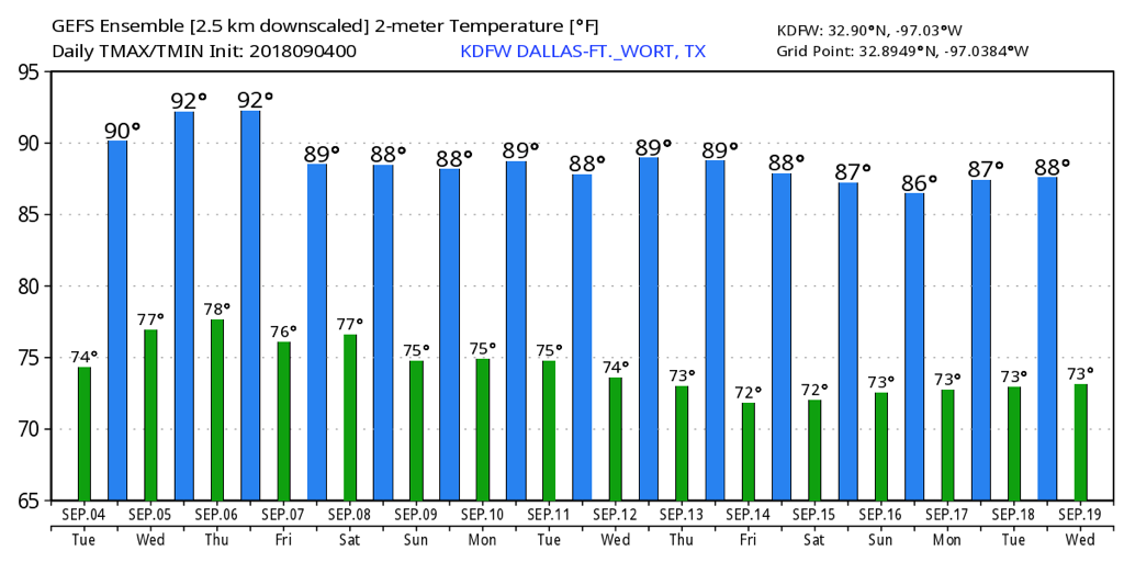 FLORENCE - Tropical Storm Florence is sill out in the Atlantic Basin with max. sustained wind of 70 mph. The global models are starting to latch onto the idea the system recurving and not impacting the East Coast. But we are still only a couple of days away from getting a real idea of where this system goes. 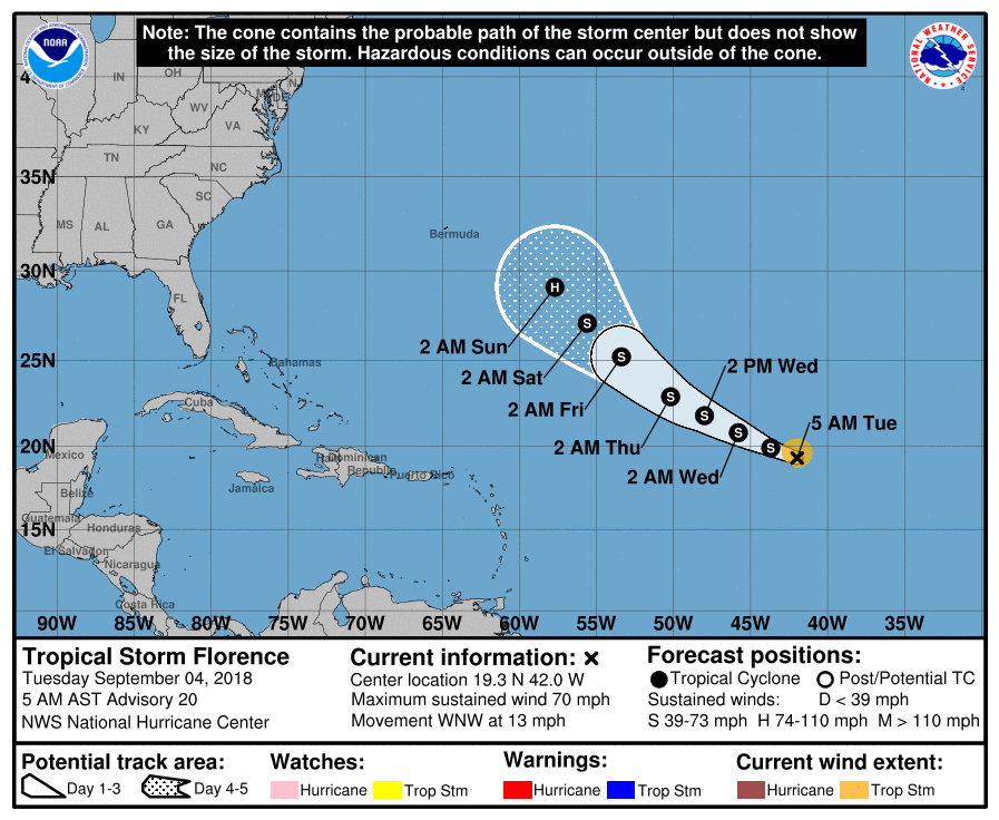 Subsequently, there’s another wave just off the African Coast that the NHC deisgnated a 50/50 chance of becoming a tropical cyclone. Way too far out to determine if this will become an issue for land areas.
|
Archives
April 2024
Categories |
 RSS Feed