
|
*no Texas Weather Discussion Video this morning* STILL HOT - We project a high around 93° this afternoon, which is still hot for late September. The sky will be sunny for the most part, and the subsidence under the upper high has put a lid on showers and thunderstorms for most of the state over the past week. Even today, we might only see isolated storms. FRIDAY AND THE WEEKEND - The upper high will weaken as a surface front pushes through the area. Rising moisture levels will also bring widespread chances of scattered showers and thunderstorms beginning Friday and for the rest of the weekend. Chance of any one spot getting wet will be in the 70/80 percent range all weekend long. Otherwise, mostly cloudy days with cool nights, and highs mostly in the low to mid 80s. NEXT WEEK - We will still maintain at least a slight chance of scattered showers and thunderstorms through a good part of next week as a long awaited cold front moves north with the support of a deep upper trough. Much cooler air should invade North Texas by Thursday with highs in the upper 70s and lows in the mid 50s... 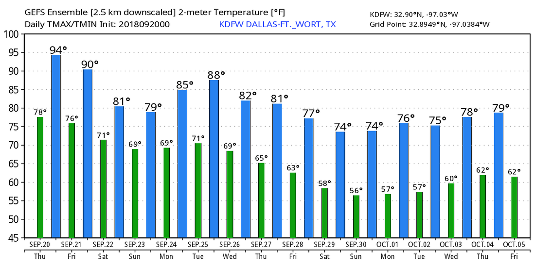 TROPICS - The Atlantic Basin is very quiet, and no new tropical cyclones are expected through the weekend.
ON THIS DAY ONE YEAR AGO - Hurricane Maria reached Category Five strength and made landfall on Dominica, becoming the first Category Five hurricane on record to strike the island. After weakening slightly due to crossing over land, Maria achieved its peak intensity over the eastern Caribbean with max. sustained winds of 175 mph and a pressure of 908 mb, making it the 10th most intense Atlantic hurricane on record. |
Archives
March 2023
Categories |
 RSS Feed
