
|
GORDON - All eyes are on Tropical Storm Gordon in the Gulf as it is forecast to make landfall on the Central Gulf Coast as a category one hurricane tonight. CURRENT CONDITIONS - Gordon has maximum sustained winds of 65 mph this morning, and is moving northwest at 17 mph, 225 miles southeast of the mouth of Mississippi River. Tropical storm force winds extend way beyond the circulation center. This storm is expected to intensify into a hurricane later today, and should landfall on the Mississippi coast with max. sustained winds to around 75-80 mph, perhaps a tad greater in some places. 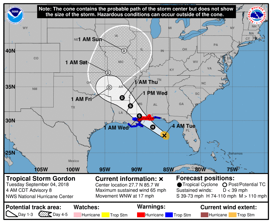 WARNINGS - A Hurricane Warning and Storm Surge Warning is in effect for the Central Gulf Coast. This storm is expected to bring hurricane-force winds and life-threatening storm surge to the coastal areas. Do not attempt to go near the waters. ON THE COAST - Weather conditions on the Gulf Coast will begin to deteriorate this afternoon and evening as Gordon steadily approaches. Here are the key notes... - Storm surge of around 3-5 feet is expected in the Central Gulf Coast during the peak impact of this system. - Rain amounts of 3-6 inches with localized amounts of 8 inches or greater is expected where the storm travels west/northwest. A flash flood watch covers much of Central Mississippi and adjacent areas/states near the Gulf Coast. - A few tornadoes and waterspouts are possible as Gordon approaches the land this afternoon and into tonight. SPC has defined the standard "slight risk" for the Alabama/extreme Florida Coastline, with a "marginal risk" for the Florida Panhandle, Southern Alabama and Mississippi. 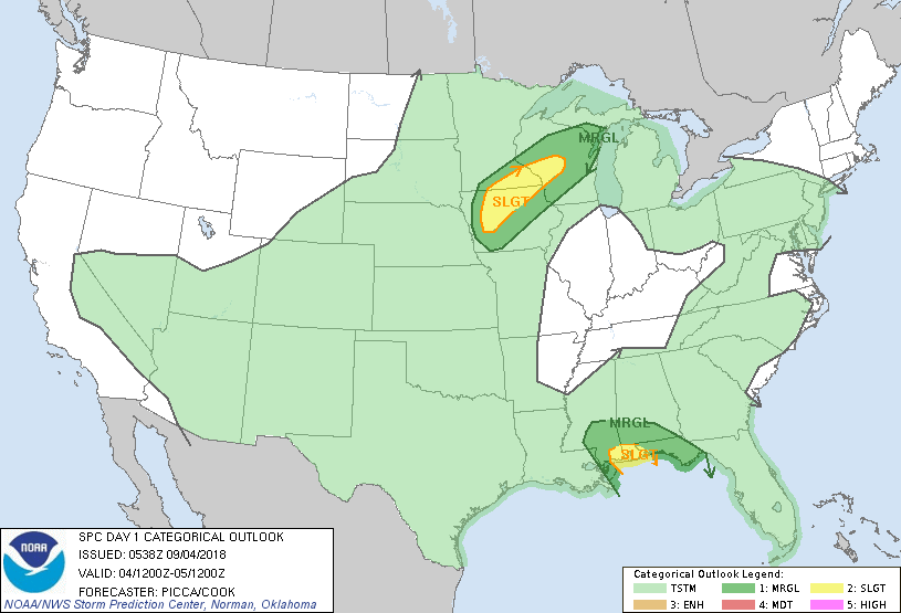 The weather over the Gulf Coast will improve significantly tomorrow afternoon, and the weather there will feature typical weather for early September with a mix of sun and clouds and risk of a passing shower or thunderstorm. NORTH TEXAS - We will most likely not see any impacts from this system as it continues its tragectory to the north/northeast once it reaches inland. The rain that we will see this week will mainly come from tropical moisture advection from the Gulf and frontal systems. Today should be mostly cloudy with scattered showers and thunderstorms about this afternoon and evening. The best chance of one spot getting wet today is 50/50, and the high wlll be in the middle 80s. REST OF THE WEEK - The risk for isolated to scattered showers and thunderstorms will remain possible for the rest of this week due to tropical moisture and frontal systems. Rain will stay isolated Wednesday and Thursday with the best chance of scattered showers and storms on Friday. The sky will remain mostly cloudy with a few instances of sun. Highs will remain in the upper 80s/low 90s for the rest of the week. THE WEEKEND - Moisture from a surface front will continue to creep into North Texas on Saturday, so we will continue to mention the chance of scattered showers and thunderstorms during the afternoon and evening hours. That front moves to the east Sunday, so we will roll with a semi-dry forecast with highs around 87-91 degrees on both days. NEXT WEEK - It sure looks like most of next week will remain dry with a mix of sun and clouds each day. Highs will be low 90s. See the Texas Weather Discussion Video for more details. 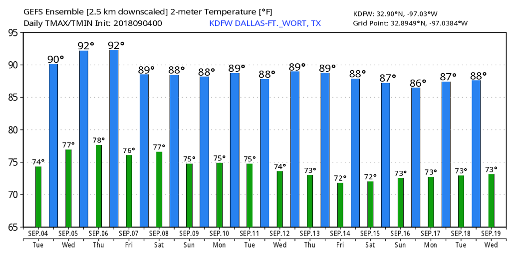 FLORENCE - Tropical Storm Florence is sill out in the Atlantic Basin with max. sustained wind of 70 mph. The global models are starting to latch onto the idea the system recurving and not impacting the East Coast. But we are still only a couple of days away from getting a real idea of where this system goes. 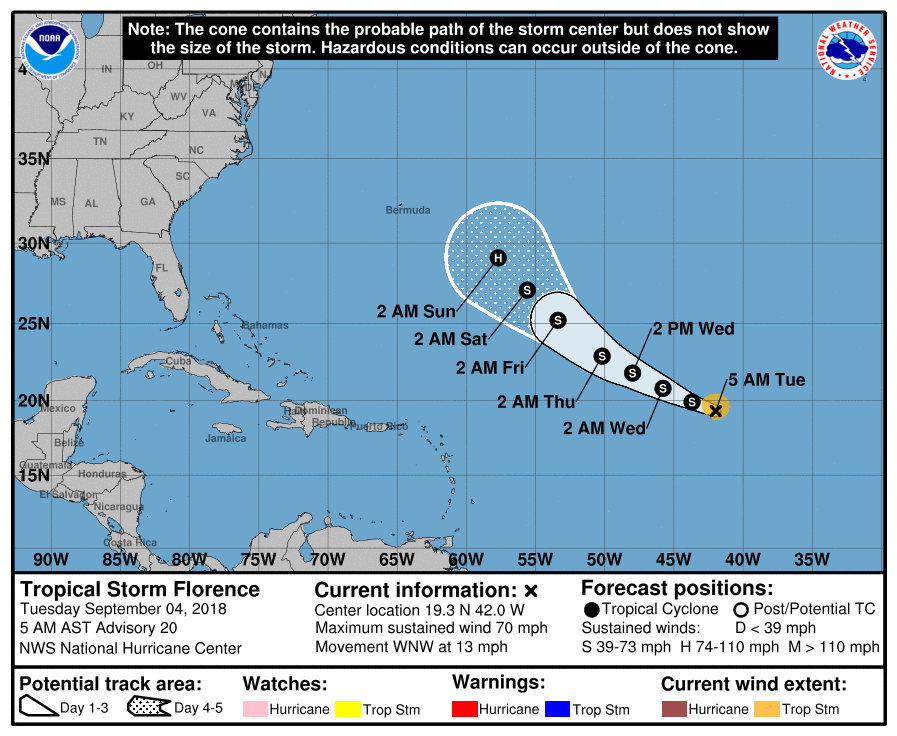 Subsequently, there’s another wave just off the African Coast that the NHC deisgnated a 50/50 chance of becoming a tropical cyclone. Way too far out to determine if this will become an issue for land areas.
|
Archives
March 2023
Categories |
 RSS Feed
