
|
NO ISSUES THIS MORNING - The only thing we might have this morning is a few morning showers over parts of eastern Texas... those will dissipate by the afternoon, and the day will be mostly cloudy and warm with a high in the upper 70s. THE EVENING - A deep surface low will be to the north of the Texas Panhandle, supported by a strong upper trough with favorable wind fields. The overall large scale pattern favors severe weather for the region, but, it will be the small scale features that will determine our overall severe weather risk. Instability values will rise during the evening, and surface-based CAPE values will be in the 2000-2500 j/kg range by the time storms develop. Shear profiles favor severe storms as well, making for a "low instability, high shear event". SPC has now put most of the DFW metroplex under the standard "slight risk", with an "enhanced risk" for much of the Ark-La-Tex region. 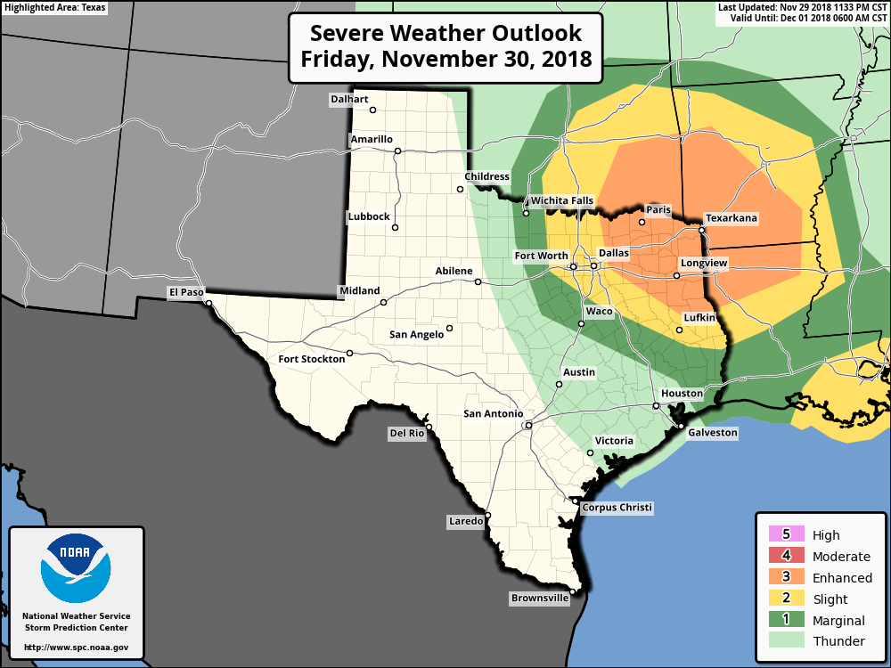 It is imperative to remember to not get hung up on these map lines and terms; storms don’t know about these lines and terms. This is just a simple guideline to let you know where the greatest potential for severe weather is today.
PLACEMENT - While all of North Texas has a risk of severe weather today, the highest risk of all severe weather modes will be confined to the north of I-20 and the east of I-35. This is where the best combination of shear, lift, and instability will be found. There will certainly be the potential for a tornado or two for the DFW Metroplex this evening, but the odds are just a little bit lower down here. TIMING - Expect the wave of thunderstorms to develop and move through the metroplex at around 5-10 PM. The best chance of severe weather will come by the early evening hours during the peak of the daytime heating process. The one thing we do not want is breaks in the clouds as it will only increase our instability and chances of seeing severe storms later this evening. We will need to remain alert for the rest of the day. THREATS - All modes of severe weather will be possible, including the potential for large hail, damaging winds, and a few tornadoes. A strong/violent tornado or two can’t be ruled out, especially in the enhanced risk area. RAIN - Rain amounts of a quarter of an inch or more is possible in some spots, so no flooding issues are expected. PLAN OF ACTION - Be sure you have a robust, reliable way of getting severe weather, which includes a NOAA Weather Radio and a good smartphone app like this one. Identify the safe place in your home, and make sure your safe place includes hard sole shoes, helmets, and air horns in case you are in trouble. THIS IS IMPORTANT!!!! - Readers they have been with us for a long time know we are exclusively weather “with a common sense approach”, meaning that we are exclusively a “no hype zone”. You will hear lots of things on social media throughout the day. There is absolutely no reason to be alarmed or panicked. This is our late severe weather season in Texas, and severe weather risks like this are very normal. We are know for being prepared for normal days like this, so just be sure you have a plan in place. Keep an eye on our Twitter page and blog for more details. THE WEEKEND - This weekend will be very pleasant with mostly sunny skies. Highs will be in the mid to upper 60s throughout the weekend. NEXT WEEK - A strong cold front comes through early Monday morning which will cause next week to be mostly dry and sunny with highs down in the upper 40s to mid to upper 50s. A storm system emerges from the Pacific Friday, and that will be our next chance of widespread rain for the state. See the Texas Weather Discussion Video for more details. TROPICS - The 2018 Atlantic Hurricane Season ends today. We have had a total of 15 named storms. 8 were hurricanes and two were major hurricanes. We were only slightly above average this year. The names Florence and Michael will likely be retired due to their significant impacts to life and property. We will be watching new model data pouring in over the next few hours into tomorrow morning, with the highest interest in developments Friday, when severe thunderstorms are becoming increasingly likely region-wide over the North Texas area. No doubt the synoptic scale suggests that it could be a bigger severe weather afternoon/evening than what we have planned for, with a deep surface low in the Texas Panhandle supported by an upper trough with very strong wind fields. We expect a very light batch of a few showers in East Texas Friday morning as moisture continues to surge northward, generally happening within the 6-12AM time frame. These will be elevated in nature, and no severe weather is expected from these showers. However, the main action should come during the afternoon and evening hours, generally between 5:00 PM and 10:00 PM. The one thing that keeps me interested on this potential tomorrow is how quickly the data elevated the potential for severe storms; some of the model guidance now suggesting shear values could exceed 50 knots by mid-evening... 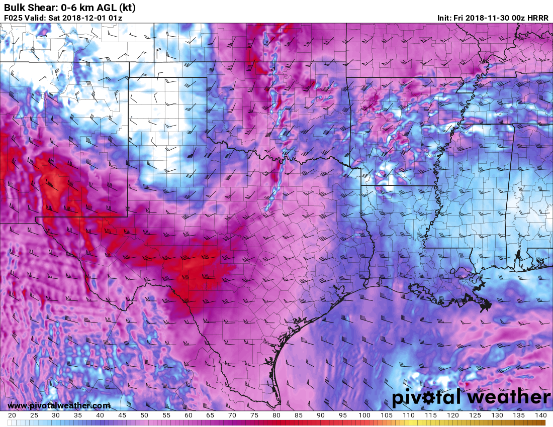 This will create a "moderately unstable, high shear" type atmosphere with decent enough buoyancy with nothing in the way of a capping inversion. Storms should develop during the peak of the daytime heating process, with afternoon highs in the upper 70s. Based on severe weather parameters such as very high bulk shear, lapse rates, moderate instability, and the lack of convective inhibition, storm initiation will start to occur around the 4:00-4:45 timeframe and intensify quickly with all modes of severe weather possible, including the potential of VERY large hail, damaging wind gusts, and the potential for a few tornadoes. Additionally, there is potential that we could see even a strong/violent tornado or two.
If these trends continue, while not likely, I would not be surprised at all if the guys at SPC put a portion of North Texas under a "moderate risk" (level 4 of 5) of severe storms sometime tomorrow. Risk upgrade or not, it looks like a fairly active evening with potential for some severe storms. PLACEMENT - With the new data, it looks like the best combination of shear instability could POTENTIALLY wind up in North Texas, but the bottom line is, the entire region of Northeast Texas will see some risk of severe storms. Additionally, it is very wise to note that we don't exactly know how the parameters will come into play during the afternoon. There is no need to be anxious or overly scared or concerned, but just be prepared SHOULD anything severe happens. Severe weather situations like this are typical during our late severe weather season, so just be prepared. PLAN OF ACTION - Be sure you have a robust, reliable way of getting severe weather watches and warnings; a NOAA Weather Radio is the standard baseline. and a good app like this one is the best way to go. Be sure to identify the safe place in your home, away from windows, and be sure everyone that lives there knows where it is. Make sure you have helmets for individuals, hard-sole shoes, and preferably an airhorn in case you need help. Be sure to follow ApexStorm on Twitter so you can watch our live feed during the events @apex_dfw_wx and @apexstormdfw. Also make sure you follow our website throughout the day for synoptic scale updates. I will have the new discussion and Texas Weather Discussion Video posted bright and early tomorrow morning... Donovan Neal Lead Forecaster Severe Weather Specialist Lead of the Band Forecast Company FEELS NICER THIS MORNING - After having morning lows in the 20s-30s at the beginning of the week, we have warmed nicely this morning with most communities in the low to mid 50s. Today will be mostly sunny and mild with highs in the mid 70s during the afternoon. FRIDAY STORM POTENTIAL - A threat of severe weather exists for some parts of North and Northeast Texas and points to the northeast as a potent storm system continues to move to the east. The SPC has the "enhanced risk" (level 3 of 5) of severe storms defined for the northeast corner of the state near Paris, Texarkana, and just to the north of Longview. The standard "slight risk" (level 2 of 5) of severe storms include areas to the east of I-35 near Dallas, Plano, Waxahachie, Corsicana, and points to the east. A "marginal risk" (level 1 of 5) risk of severe storms encompasses the rest of North Texas. 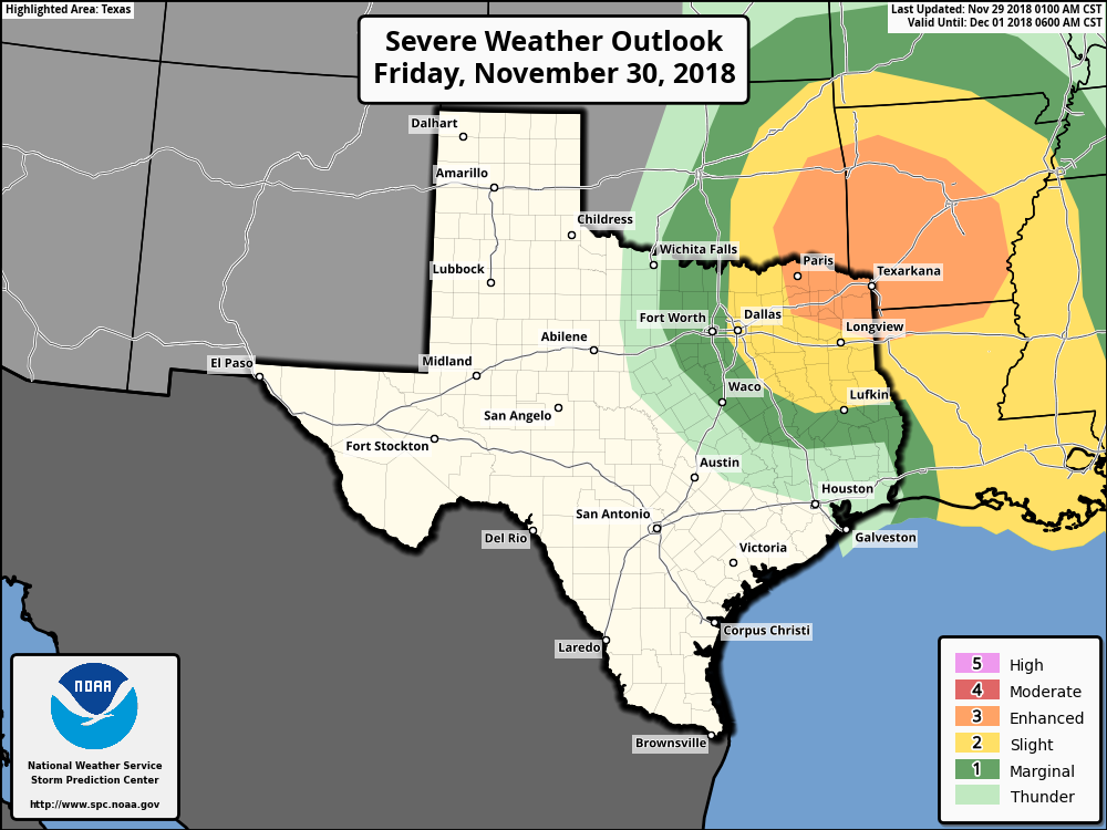 IMPACT - For those that are closer to the enhanced risk area, all modes of severe weather is possible, including the potential for a few tornadoes at times. Hail can be expected at times as well. Closer to home, we will watch the few storms that develop for severe potential, but it does look like key parameters and overall coverage of the storms could be out of fruition for a big severe weather issue. TIMING - Wet weather is likely in the broad 12 hour window of 4:00 PM - 4:00 AM tomorrow afternoon and evening. It definitely won't rain all 12 hours, but a few storms during that time period is likely. However, the latest runs of the NAM (North American Mesoscale) model shows most of the activity staying to the east of the DFW Metroplex. Don't expect much impacts for DFW, if any, and most of the day should be dry with a mix of sun and clouds. Highs will be in the mid 70s. THE WEEKEND - Look for basically perfect weather conditions this weekend with a pleasant sky and cool nights. Highs will be near 70 on Saturday, followed by mid 60s on Sunday. NEXT WEEK - An upper high in the high plains will bring colder air to the state starting Monday with highs starting in the mid 50s. We get a tad cooler throughout the week, but we still maintain mostly sunny skies. Our next wave towards Friday and Saturday will bring more rain to the state Friday night and Saturday during the day. At this time, this does not look like a severe weather issue at all. See the Texas Weather Discussion Video for more details. 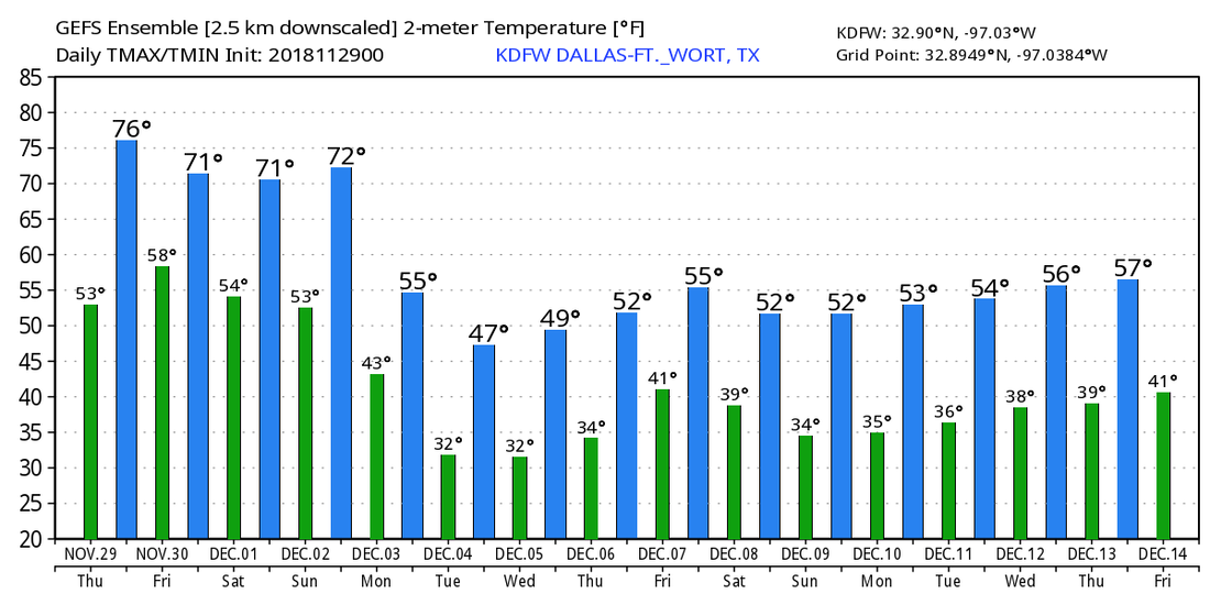 CHILLY NOVEMBER MORNING - Temperatures across North/North-Central Texas are mostly on seasonal averages for lows... mostly in the low 40 degree range. The sky is clear, and the winds will shift to the south for the next couple of days. We will be sunny today with a light wind to the south as the warming trend begins... We will rise to around 70 degrees this afternoon. We turn even milder tomorrow with mostly sunny skies. We will be in the mid 70s tomorrow afternoon. FRIDAY AND THE WEEKEND - Clouds will increase during the day on Friday, and a few widely isolated showers could break out during the evening hours near the DFW metro. Then, Friday evening will have a mix of sun and clouds with a chance of strong storms over the northwestern part of the state. The high on Friday will be in the mid 70s. To the east of us, it looks like strong to severe storms will develop in a zone to the east of Dallas to around Tulsa as a potent surface low approaches. The SPC has outlined the standard "slight" risk of severe storms for areas to the east of Dallas to around Tupelo, Mississippi, and a "marginal" risk for the surrounding areas for their Day 3 outlook... 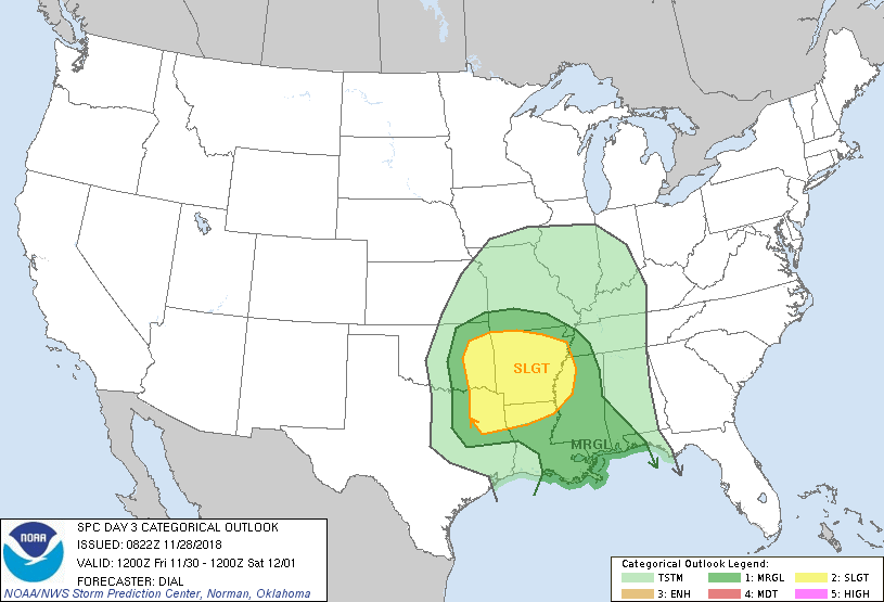 Right now, confidence is increasing that most of North Texas will be severe clear of any severe weather issues Friday evening, with an exception of maybe a few isolated thunderstorms at times. Highs will be in the mid 70s with a mix of sun and clouds. THE WEEKEND - We turn pleasant for the first couple of days of December. We remain mostly sunny throughout the day with highs mostly in the mid to upper 60s which is actually above our average high of 62 degrees for this time of the year... NEXT WEEK - At this time, most of next week looks mostly dry with highs in the low 60s on Monday, followed by highs in the low 50s for the rest of the week with a potent cold front coming through. Confidence is increasing that our next chance of widespread rain is on Friday, November 7 as another storm system moves through. At this time, we do not anticipate a severe weather issue with a relatively cold airmass, but rain is looking more and more likely throughout the day. See the Texas Weather Discussion Video for more details. 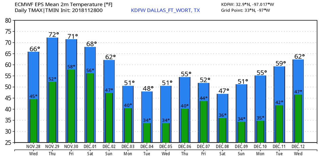 ANOTHER COLD MORNING - Temperatures across North Texas are in the 20-30 degree range with colder temperatures in the north. Not quite a freeze here in the DFW Metroplex, but the good news is we will rebound nicely to the low 60s for highs today with a mostly sunny sky. The wind will shift to the southwest as the trough in the Great Lakes continues to move northeast. We fall to the low 40s Wednesday morning, but again we rebound nicely to the mid 60s with mostly sunny skies. Then, Thursday will be sunny with highs in the low 70s. FRIDAY AND THE WEEKEND - A good part of Friday remains mostly sunny and dry with highs in the low 70s by the afternoon. A storm system will move through during the day, but confidence is increasing that the instability in North Texas will not interact with the moisture from the Deep South to cause a severe weather threat for North Texas, so the SPC has shifted the risk of severe storms eastward, further into the Deep South and Lower Mississippi River Valley. We could see an overnight chance of a few scattered showers and thunderstorms, but the best chance of any one spot getting wet is only in the 20-30 percent bracket at this time. The rest of the weekend looks very nice. Saturday will be a comfortable day with a mix of sun and clouds with highs in the mid 60s. We get rid of the clouds on Sunday, and highs will be in the mid 60s again. Very comfortable weekend conditions. NEXT WEEK - A relatively quiet pattern continues, staying mostly dry for most of next week, followed by another blast of cold air towards the latter half of the week. See the Texas Weather Discussion Video for more details.  TROPICS - The 2018 Atlantic Hurricane Season ends this Friday, and tropical cyclone development is not expected anytime during this week. The 2019 season begins June 1, 2019.
WINDY AND COLD - A very tight pressure gradient in wake of a cold front brought windy conditions to North Texas yesterday with many places seeing gusts of up to 30-35 mph in some spots. These winds ushered in cooler air last night, and will make it feel like the 20s in most spots this morning; despite mostly sunny skies today, temperatures will struggle to get out of the 40s this afternoon as a result of a 10-15mph northerly wind. TOMORROW THROUGH THURSDAY - We will see conditions slowly get milder each day with the winds eventually subsiding. Morning lows will be in the low 30 - mid 40 degree range, slowly getting warmer each day. Look for a full supply of sunshine throughout the week with highs in the mid 50s on Tuesday, followed by low 60s on Wednesday, and a high closer to 70° on Thursday. STRONG STORMS POSSIBLE FRIDAY - A vigorous storm system will bring strong to severe storms to the Ark-La-Tex region Friday. A deep surface low will be located near the Panhandle, and moist, unstable air will surge to the north from the Gulf of Mexico. Parameters suggest that severe storms will be possible across the region, but it is still too early to determine the exact placement, timing, and the magnitude of the severe threat. Rain amounts Friday of one inch or greater is possible, and most will see a high in the low 70s.  THE WEEKEND - With the exception of a few rain showers at times, Saturday and Sunday look mostly dry with a mix of sun and clouds. Highs will be in the low 60s both days. NEXT WEEK - Colder air will invade the South with the progression of a very deep trough near the Rockies on Monday (see my graphic on Twitter for more details). Colder, chilly weather will be in store for at least early next week... See the Texas Weather Discussion Video for more details.  BIG NOVEMBER BLIZZARD - Blizzard conditions brought travel to a halt from Central Kansas to Chicago yesterday. The snow total in Kansas City was 5/8", which is a record for that day, and the second snowiest November day on record. Winds gusted to 55mph at the Kansas City International Airport during the blizzard.
ANOTHER COLD MORNING - Temperatures are mostly in the upper 20s to low 30s for most communities. This should be our last morning below freezing for a little while. We start to warm up tomorrow and the weekend, and each morning will feature a low warmer than the day before. Today will still feel cool with highs mostly in the low 60s and upper 50s, then we warm more to the mid 60s on Friday, making for a very comfortable, fall Friday. Each day will feature mostly sunny skies. THE WEEKEND - Weather for the weekend will feature a mix of sun and clouds with comfortable highs. Saturday's high will be in the mid 60s. A cold front comes through early Sunday morning, which may carry a few showers and mostly cloudy skies for most of the day. Afternoon highs will be in the mid 50s as result of cold air advection from the front. THANKSGIVING WEEK - The weather in North Texas looks mostly dry Monday and Tuesday with highs in the low 60s in most spots. The latest run of the GFS now holds the next chance of rain back until Thursday afternoon rather than Wednesday... That could very well chance seeing how we are a week away from Thanksgiving. For now, the Iron Bowl next Saturday looks very dry... See the Texas Weather Discussion Video for more details.  TROPICS - The Atlantic Basin remains very quiet, and tropical cyclone formation is not expected anytime soon.
MORE FREEZING WEATHER - Temperatures are in the low to mid 20s this morning with a singular reading of 17° out in Graham. DFW was at 26° as of 5:05, which is 5° below our record low for November 14. The deep, cold core trough that has been parked in Texas for the past couple of days will finally begin to lift over the next 24 hours. It will be another cold day with highs in the mid 40s. However, with the cold trough gone, we will start feeling warmer by tomorrow afternoon. Although we will start the day below freezing, we will warm to the mid 50s Thursday afternoon with mostly sunny skies. Warmer weather will continue through the weekend. FRIDAY AND THE WEEKEND - Look for a very pleasant weekend overall with highs in the upper 60s and lows in the 40-45° range for Friday and Saturday. A cold front comes through Sunday morning, and we might see a few scattered showers from that. Clouds will increase Sunday, and highs will remain in the mid 50s. THANKSGIVING WEEK - The weather looks dry Monday and Tuesday with highs mostly in the upper 50s to low 60s with a mix of sun and clouds. Global models continue to advertise a low in Southern Texas that will bring rain to much of North and Central Texas on Thanksgiving eve, one of the busiest days of travel of the year. Then, Thanksgiving Day and Black Friday look dry again with a mix of sun and clouds... See the Texas Weather Discussion Video for more details. 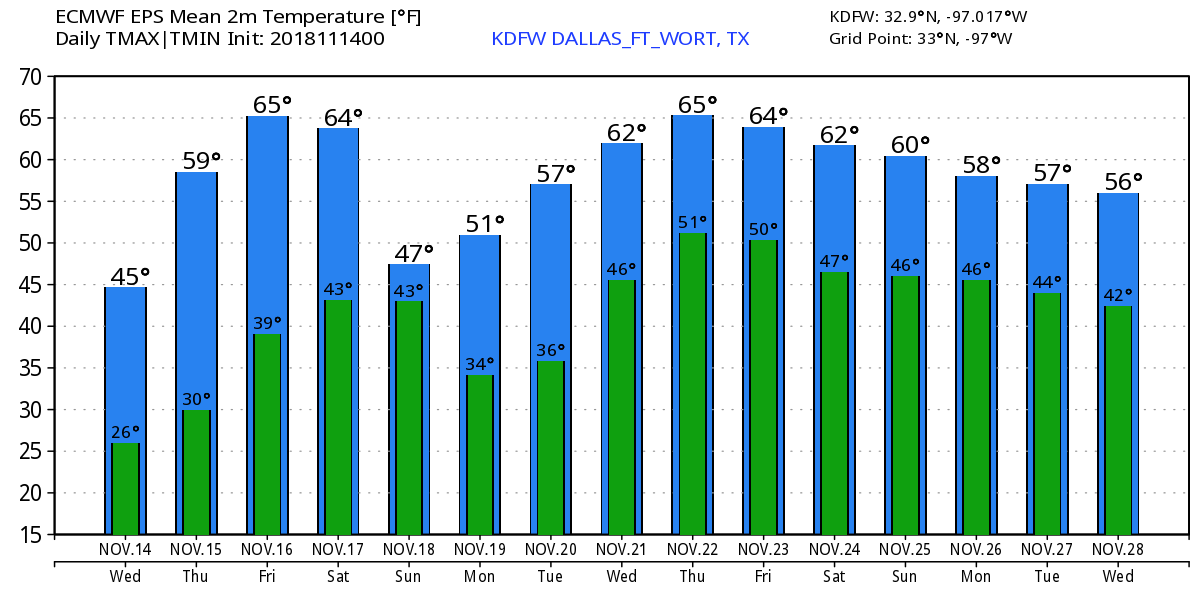 TROPICS - The disturbance near Puerto Rico is not expected to develop. The rest of the Atlantic Basin remains quiet.
FREEZING START - As advertised, temperatures are currently in the upper 20s to low 30s this morning. DFW's official low now is 31°, which is just two degrees shy of the record low of 29° for November 13. With much drier air than expected filtering into North Texas, all of the roads are fine, so no icy conditions anywhere is expected today. However, do bring the heavy coat, hat, and gloves. Although highs will be in the upper 30s/low 40s, the wind chill will make it feel 10-20 degrees cooler with a northerly wind. Morning lows tomorrow will be in the mid to upper 20s, and the record low for DFW on November 14 is 29°, set in 1959. At this point, we are on track to surpassing that with a raw, cold airmass in place. Highs will only get to the mid 40s tomorrow with a mostly sunny sky once again. WEDNESDAY THROUGH FRIDAY - Not much change. We gradually get warmer each day with sunshine in full force everyday. Highs will be in the mid 40s on Wednesday, followed by highs in the mid 50s by Thursday and low 60s by Friday. We will likely start each morning below freezing until we get to Friday, which we will start in the upper 30s. THE WEEKEND - Saturday will be dry for most with highs in the low 60s with mostly sunny skies. A cold front comes through early Sunday morning which will being clouds and highs in the low to mid 50s with mostly cloudy skies. We might see a shower or two ahead of the front. THANKSGIVING WEEK - For now, most of Thanksgiving week looks mostly dry with more clouds than sun on most days. Highs will mostly be in the upper 50s to low 60 degree range for most communities during the week. See the Texas Weather Discussion Video for more details. 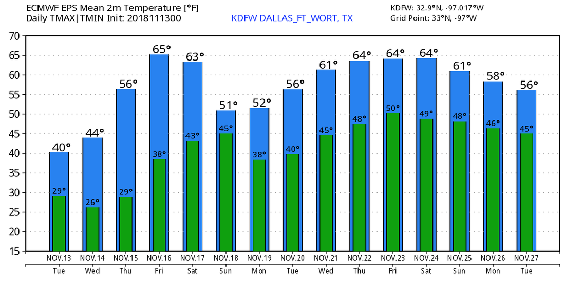 TROPICS - A disturbance on top of the Leeward Islands still has a 40% chance of development, but won't develop anytime soon due to non-conducive environment. Even if it does develop, it should recurve into the Atlantic well before getting close to the US.
COLD IS THE WORD - Just about everyone in the region of North Texas should experience below freezing temperatures sometime this week. But for now, light rain is still moving east through North Texas, and will continue throughout most of the afternoon. For now, winter weather is not expected, although there is a very small chance of some of the light rain turning into a light wintery mix in some spots, but I wouldn't count on it. If the forecast continues to verify, most places will become dry during the late afternoon/evening. With the cold front coming through, temperatures will go the wrong way throughout the day. We start in the low 40s now, but we will be closer to the upper 30s by the afternoon. MIDWEEK - We will turn very cold tonight/tomorrow morning with many places seeing a hard freeze in North Texas. Tomorrrow's forecast low is around 28 degrees, Wednesday's is around 27 degrees, which will beat the old record low of 29 degrees set in November 14, 1959. Both days will feature a mostly sunny sky with highs in the low to mid 40s, but it will feel colder than that with a northerly wind creating a wind chill. THURSDAY/FRIDAY - We start to warm substantially after Thursday. We will still have a freeze on Thursday, but we will warm to the mid to upper 50s with a mostly sunny sky. We will actually start Friday above freezing with highs in the low 60s. Each day will feature a mostly sunny sky. THE WEEKEND - Saturday and Sunday will be dry, cool days featuring mostly sunny skies with highs in the 56 to 63 degree range and lows in the low 40s. NEXT WEEK - The first half of Thanksgiving Week will be mostly cloudy and rainy with highs in the upper 50s to low 60s.... See the Texas Weather Discussion Video for more details. 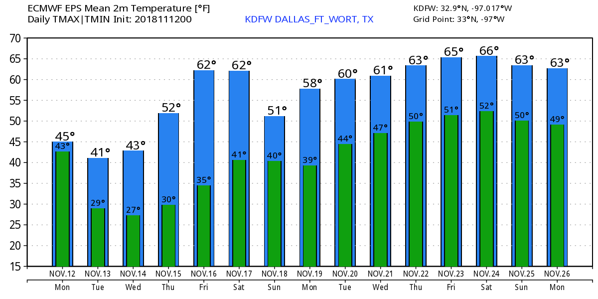 TROPICS - There is a disturbance east of the Bahamas that has a high chance of developing to tropical depression or storm within the next few days. This will most likely curve out into the Atlantic, posing no threat to the US.
CHILLY MORNING - Temperatures are in the the middle 40s this morning, still much colder than the previous morning. Today will be a brisk, chilly day with highs mostly in the upper 40s for most of the day. A northerly wind of around 10-20 mph will make it feel even chillier. The sky will be mostly clear tonight. THE WEEKEND - Most places in DFW will experience the first frost or freeze of the season as morning lows fall to the low 30s. A Freeze Watch is now in effect for the greater DFW Metro and points to the north Saturday morning. The watch area could extend farther to the south as conditions warrant.  Most of the day on Saturday will feature more clouds than sun with afternoon highs in the low 50s. Sunday will feature mostly clouds with highs in the low 50s and morning lows in the low 40s. NEXT WEEK - Global models still indicate some wintery mischief possible for parts of North Texas Monday evening through Tuesday morning. Since large uncertainties still exist, we will opt to not include any wintery mix chances in the official chances. However, the main concern is the cold rain that will fall in substitute of the wintery mix. If we see enough rain Monday evening, that may cause a difficult situation Tuesday morning as temperatures fall to the upper 20s for most spots. If that verifies, anything that falls Monday evening/night will freeze by the morning, causing an icy situation for roadways, bridges, and overpasses, which will cause problems traveling to work and school. Although we are uncertain about the possibility of a wintery mix for parts of North Texas, we are certain about the chance of widespread rainfall and the possibilities of record lows for some locations in North Texas Tuesday morning. We will continue to watch this. Just stick to the latest forecasts for more details. Monday and Tuesday looks like cold, raw, muggy days with highs only reaching the low to mid 40s. The rest of the week will warm with highs in the low 60s by Friday... See the Texas Weather Discussion Video for more details. 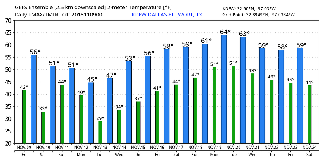 CLOUDY AND CHILLY - Temperature are in the low to mid 50s this morning with a mostly overcast sky. Clouds will hang strong across North Texas today with rain at times mainly during the afternoon and evening hours. On Friday, some lingering showers is likely mainly during the morning hours as the moisture starts to get pushed to the north. We won't warm much at all during the day. We will hover in the low 50s throughout the afternoon, with some places falling to the upper 40s. And, temperatures will start in the low 40s Friday morning. Friday will be a chilly, blistery day as temperatures will stay in the low 50s with a north 10-20 mph wind. The sun should be out at times, though. THE WEEKEND - Mornings will be very cold; we project a low between 30 and 36 degrees both Saturday and Sunday morning with frost likely in most spots. Some places could see their first freeze of the season. The sky will be sunny on Saturday with highs only in the upper 40s. Clouds will increase Sunday with afternoon highs in the mid 40s. NEXT WEEK - A very cold rain is likely throughout the day on Monday with highs struggling to get out of the mid 40s throughout the day. Rain will end very early Tuesday morning, but Tuesday will likely be a raw, cloudy day with a brisk north wind of 12-20 mph, so it will feel much, much colder. Then, Wednesday morning will feature lows down in the upper 20s for some spots, right at the record temperature for November 14. The day will feature a mix of sun and clouds with highs in the upper 40s. The rest of the week and next weekend will be mostly dry with a slow warming trend... See the Texas Weather Discussion Video for more details. 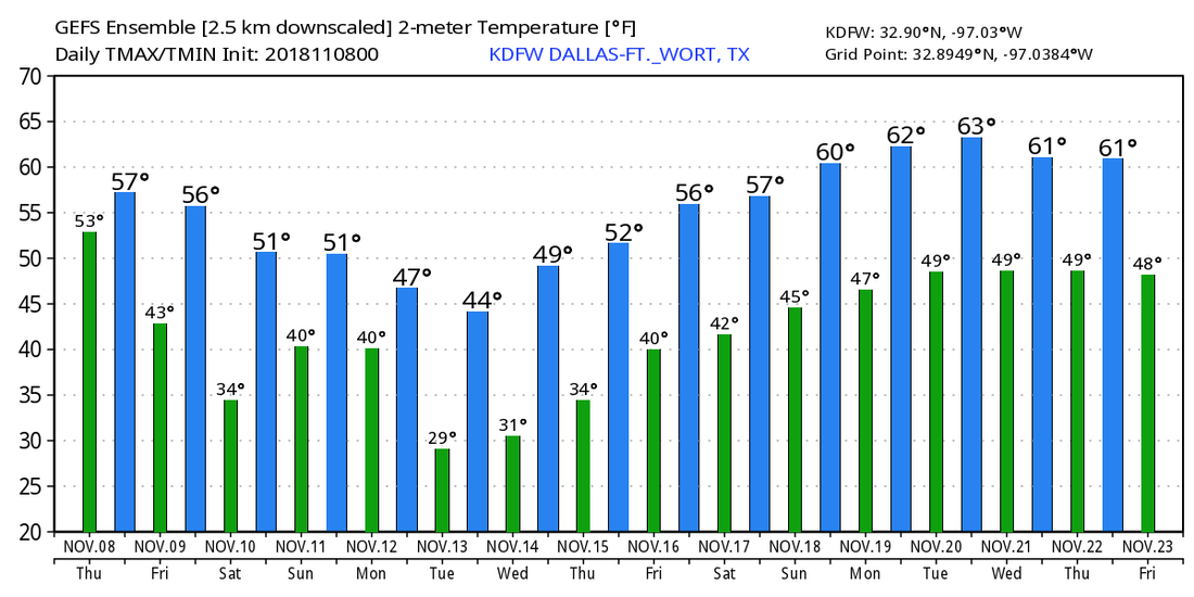 UNSETTLED WEATHER RETURNS - Clouds will return to North Texas today, and we expect any rain to be scattered and light throughout the state this afternoon and tomorrow. The high this afternoon will be in the low 60s for many communities. Clouds will continue to stick around tomorrow and into some parts of Friday, and we will mention rain at times both days. We will reach the upper 50s tomorrow, but temperatures on Friday will cool down to the low 50s as the coldest air of the season rolls in from the north. The sky will clear Friday afternoon. THE WEEKEND - Sun will return to the region for the weekend, but temperatures will stay well below average for mid-November. We expect lows to be around the 32-38 degree range both mornings, but the colder pockets will reach the freezing mark. The average first freeze in DFW is usually November 22, so we will be two weeks early if this happens. NEXT WEEK - Our next push of cold air will come as soon as Monday hits. This time, we expect some rain at times ahead of the cold air on Monday. Yes, the GFS does show some wintery precipitation across the Texas Panhandle Monday afternoon, but it looks like temperatures will not be cold enough for winter precipitation to reach North Texas at this time, but we will continue to keep an eye on it. Sunshine will return Wednesday, but we may drop to the 20s in some spots early Wednesday morning. The record low for November 7 is 29°, set in 1959. We may come close to that... See the Texas Weather Discussion Video for more details. 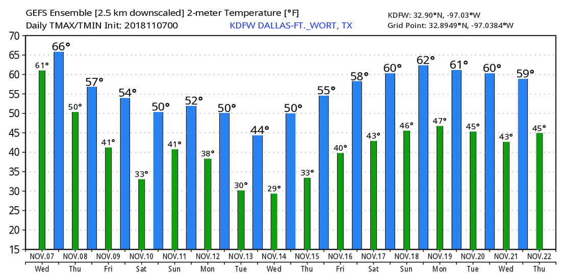 TROPICS - The Atlantic Basin continues to remain quiet for the rest of the week.
SEVERE CLEAR - Temperatures are in the low 50s this morning with fair skies... Today will be another pleasant day with abundant sunshine with afternoon highs in the mid 70s later. :) A cold front arrives late Tuesday night/early Wednesday morning, which will keep lows in the upper 40s and highs in the low 60s. A few isolated showers/thunderstorms could develop from the front during the afternoon, but the best chance of a spot getting wet is only in the 20/30 percent category. THURSDAY/FRIDAY - Temperatures will only continue to get colder from here. The cold front stalls in South Texas, and moisture will continue to overspread the region. Thursday's high will be in the mid 50s with lows in the upper 50s. Yes, we will still deal with scattered showers and thunderstorms. The best chance of any one spot getting wet is in the 50/50 category. Not much change for Friday other than the fact that we will have a colder morning with lows in the upper 30s, as well as we get rid of rain chances. Some of the colder pockets could see some frost in some communities. Highs will only be in the low 50s, rendering a very chilly Friday. THE WEEKEND - An upper high in the central High Plains pushes the coldest air of the season down south, as well as freezing and below freezing temperatures for parts of North Texas. Saturday's official morning low is 34°, but some of the colder spots will experience the first freeze of the season, ending the 2018 growing season in some spots. Elsewhere, you can expect widespread frost with temperatures hovering just above the freezing mark. Otherwise, expect another chilly day with highs only in the low 50s. Sunday will also be very chilly with highs in the mid 50s with overnight lows in the upper 30s. NEXT WEEK - We stay below the mid 50 mark for highs for much of the workweek. We will likely see some frost each morning with morning lows mostly in the 30 degree range. Otherwise, most of next week looks dry. And, as noted everywhere, the Climate Prediction Center (CPC) denotes an 80% chance of below average temperatures for the 6-10 day forecast period for North Texas and much of the Central US, meaning very chilly air is on the way. See the Texas Weather Discussion Video for more details. 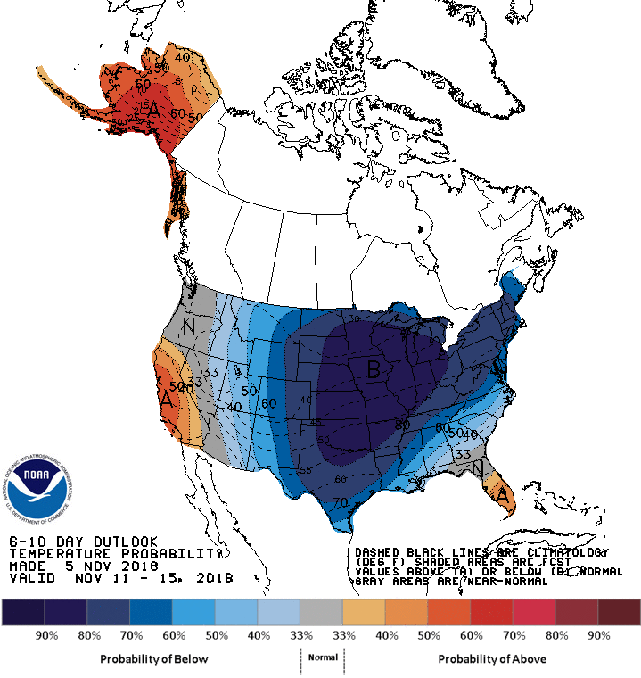 COOL START - Although temperatures are currently in the mid 50s, it will be a rather warm day today with highs nearing 80° this afternoon. We expect clouds to slowly diminish by the afternoon. It will also be very windy with a southwest wind of 20 mph. A cold front arrives tomorrow morning in dry fashion, and we will continue to mention mostly sunny skies. This time, afternoon highs will be in the low 70s with morning lows in the mid 50s, still very slightly above average for early November. While North Texas enjoys comfortable weather, parts of Dixie Alley will face the threat of some severe weather today with an "enhanced risk" (risk 3 of 5) of severe storms for much of Mississippi and parts of Tennessee and Alabama, with the standard slight risk surrounding those areas. 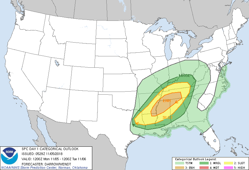 All modes of severe weather will be possible, including the risk of damaging winds, large hail, and a few tornadoes. This threat will start in the evening, and continue through the nighttime. WEDNESDAY THROUGH FRIDAY - The southern flank of a cold front reaches down to North Texas, and we could see a few scattered showers and thunderstorms during the middle of the workweek as a result. The best chance of one spot getting wet will be in the 30 percent bracket, and nothing should be widespread. Moisture will persist into Thursday, so we will mention even greater rain chances there. Highs will be in the mid 60s on both days with mostly cloudy skies. An upper high pressure will do a sufficient job of pushing cold air southward, so we will begin to cool down on a noticeable level by Friday. Highs will be in the low 50s with morning lows in the mid to upper 30s. We could see some frost in the morning, but temperatures will not be cold enough for a widespread freeze. THE WEEKEND - Not much change. We will stick with a dry and pleasant weekend with highs in the upper 50s with morning lows in the low 40s with a mostly sunny sky. NEXT WEEK - Global models have been consistently showing the risk for some "winter mischief" for parts of North Texas with a surface front moving down from the north. That would mean a chance of snow with freezing temperatures early Monday morning. However, the models have been rather bullish on that idea, so we will continue to leave a dry forecast with highs in the mid to upper 50s with a mostly sunny sky. Based on latest trends, our first freeze of the season likely comes November 14. See the Texas Weather Discussion Video for more details. 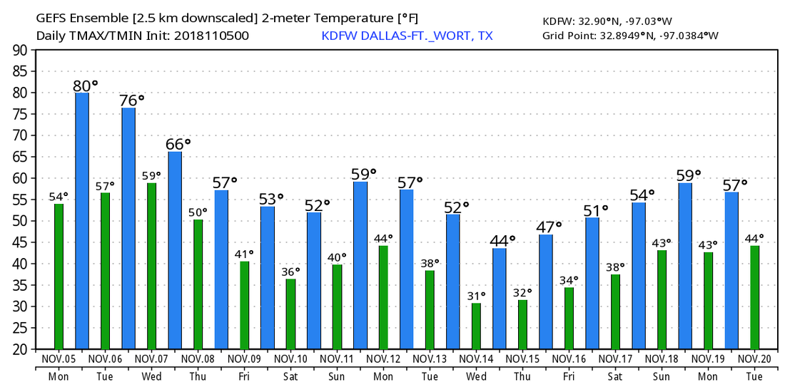 TROPICS - The Atlantic Basin remains very quiet, and will continue to do so over the next week.
*no Texas Weather Discussion Video this morning* CHILLY AND DRY - A mostly fair sky is in place over the region of North Texas. Temperatures are in the 40s, but we will warm to the upper 60s/lower 70s today with mostly sunny skies, absolutely perfect weather for high school football games later this evening. THE WEEKEND - Most of the weekend stays mostly dry with highs in the mid 70s for Saturday. A cold front comes through during the early morning hours Sunday, which could set off an overnight round of showers and thunderstorms. We clear for the preceding day, starting off with clouds in the morning, starting off with mostly sunny skies by the afternoon. Highs will be in the mid to upper 60s on Sunday. POTENTIALLY DANGEROUS SEVERE WEATHER OUTBREAK EARLY NEXT WEEK - A deep, negatively tilted trough will develop across the Central US to add dynamic support to very strong winds aloft, and a rapidly instenifing surface low will move from the Red River all the way to Chicago. This will bring a very robust severe weather setup to the southern US Monday into Tuesday for much of the Deep South, east of Texas. Based off of shear and instability values coming off of models, it looks like we will very well see the threat of semi-discrete supercells with potential for large hail, damaging winds, with the potential for violent, long-track tornadoes. At this time, the best window for a significant severe weather event looks to be from Monday afternoon to very early Tuesday morning, as the SPC notes.  With the severe weather threat more than 90 hours out, and with models still subject to change, will refrain from diving head first into the potential for a tornado outbreak. However, with good model trends, the current pattern NOW, and the time of the year, I would STRONGLY recommend everyone in the affected areas review their severe weather safety plan this weekend. - Make sure you have multiple ways of receiving severe weather warnings. Having a NOAA Weather Radio in your home is a MUST (be sure to change out the batteries when we fall back this weekend!). Moreover, make sure your have a good app on your phone that's designed to alert you for warnings, like this one. NEVER RELY ON OUTDOOR WARNING SIRENS!!!!! - If severe weather threatens your area, know where to go. If you are in a home, go to a small closet/bathroom on the lowest floor away from any windows, near the center of your house, if at all possible. If you are in a mobile home, be sure to know the locations of nearby sturdy shelters and have a way to get there in a moment's notice. - In your pre-designated safe place, have a readiness kit which includes helmets for everyone (football, bicycle, or batting helmets will suffice), portable airhorns, and hard-sole shoes. Keep in mind that these severe weather threats are typical because we are in our late severe weather season. So be sure to give everyone you know a heads up about this dangerous threat. REST OF NEXT WEEK FOR TEXAS - The weather will be mostly cool for Tuesday through Friday with highs in the low 60s... 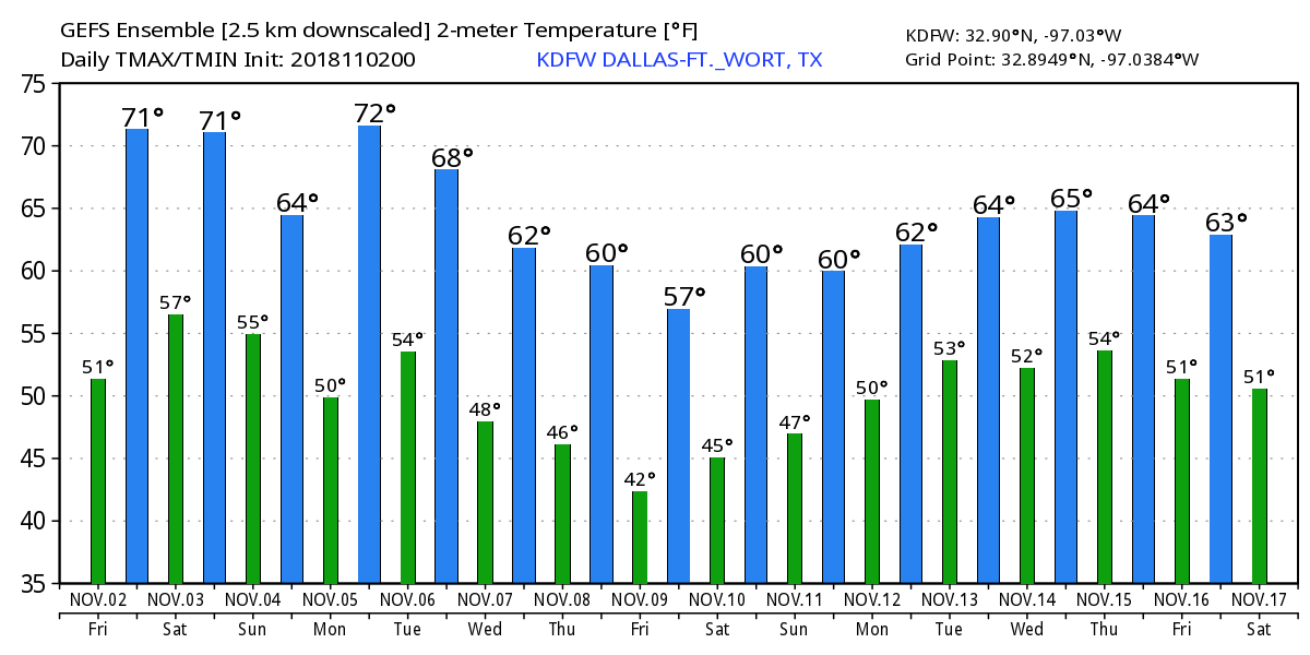 TROPICS - The Atlantic Basin remains very quiet, and tropical cyclone formation is not expected through next week.
SEVERE CLEAR - No showers or thunderstorms to be seen on the radar this morning... Just clouds and temperatures in the low 50s this morning. It will be a cool, breezy day with afternoon highs only reaching the low 60s in most spots, which is about ten degrees below our average high of 73°. We turn even clearer on Friday with highs warming to the upper 60s/low 70s with lows in the low 50s, perfect weather for high school football games during the evening. THE WEEKEND - Saturday stays mostly dry with afternoon highs in the low 70s... A cold front comes through during the early morning hours on Sunday, which may trigger a chance of scattered morning showers and thunderstorms. A few of those may persist through the afternoon. It will not be as heavy as yesterday, and rain amounts of around 0.4 inches or less is expected this weekend. Sunday's high will be in the low to mid 60s. NEXT WEEK - At this point, most of next week looks dry and sunny with afternoon highs in the 60 degree range. A weak surface low may spin up a few showers and thunderstorms during the morning hours on Tuesday, but nothing widespread. See the Texas Weather Discussion Video for more details. 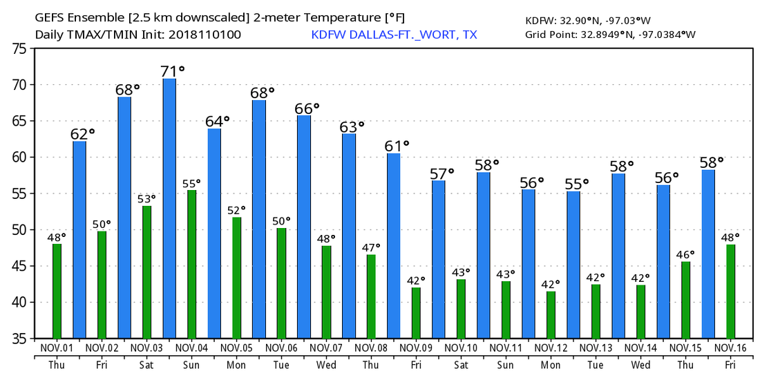 TROPICS - Oscar is now a post-tropical cyclone in the Northern Atlantic where it will continue to move to the north and dissipate. The Atlantic Basin remains very quiet. The 2018 Atlantic Hurricane Season will end at the conclusion of this month.
|
Archives
April 2024
Categories |
 RSS Feed