
|
Hello North Texas! We have a really exciting weather week ahead of us and so many possible outcomes could happen just in the span of a week. I’ll try my best to give a brief overview of everything and some of the events might warrant a second blog post soon.
EARLY WEEK: The rest of Sunday and Monday will be relatively uneventful, with highs in the 70s today and a cloudy day in the 60s on Monday. However, by early Tuesday morning, moisture from the gulf is expected to bring some brief showers. It’ll be relatively seasonal with temperatures in the 60s as precipitation starts around midnight, and it will linger throughout the day with spotty showers and low stratus clouds making it an overall gloomy day. The moisture will be ahead of an upper level low that is projected to track over Texas starting from the Mexico/New Mexico area, and that upper level low provides for a tricky but intriguing scenario on Wednesday. SEVERE WEATHER AND SNOW: The track of the upper level low will determine exactly what happens in the next few days. Wednesday is probably for some severe weather near the metroplex, as the low sweeps through Texas. A few thunderstorms can’t be ruled out for DFW proper, but there’s differing model solutions for exactly where and how severe the weather will be. The global models have a wider swath of precipitation whereas the NAM has a tighter squall line. I think the DFW metro area will likely see some morning storms without a chance for hail, with a potential for some strong winds and thunder. However, as this upper level low tracks across Texas, we have a very decent chance at some wintry weather. While a wintry mix is the most likely solution, the track of the low could turn that into more substantial wintry weather. We won’t have any issue with QPF (precipitation) which places it all on the track of the low. The CMC and UKMET shows a very low, deep trough, with plenty of wrap around snow in the DFW area, with accumulations of around 4 inches. The GFS, however, pulls back with the trough and shows higher accumulations in Central Texas, with only a dusting in NTX and more prominent ice accumulations in DFW due to a stronger warm nose. The NAM isn’t quite at a good range and doesn’t show anything yet for Texas, but the Euro and the NAM look to be heading towards a mix of the two solutions and I would mostly agree. I think, just for caution’s sake, to plan on a wintry mix that develops as a changeover on New Year’s Eve, with a light dusting of snow overnight into 2021. For how poor 2020 has been for mostly everyone, ending it with a little bit of winter fun would be the perfect way to transition into the New Year. We here at ApexStorm will keep you up to date! Stay warm, stay safe, and stay weather aware! -Colin Welty 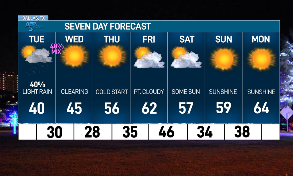 Hello everyone! I’m back with another updated blog for our next week of weather. Many areas across North Texas saw some flakes last night with some wrap around precipitation after Sunday’s upper-level low! It marks the first wintry precipitation much of the region saw this winter, though many places still didn’t see anything. However, there is another upper level low moving over North Texas tomorrow and there are a lot of uncertainties on what will happen. I’ll take a look at it in this blog. TUESDAY SNOW? Overnight tonight, an upper level low will move from northwestern Oklahoma to over North Texas, with a track somewhat similar to the system from yesterday. There will be a high amount of dry air aloft throughout the bulk of the day despite a very moist DGZ, reducing any potential for rain as the day progresses. While Oklahoma is projected to get a decent amount of snow throughout the day, the chance for precipitation is negligible for DFW and surrounding North Texas areas, with any precipitation that does fall being very light. However, as the low moves through the area, there is a potential for wrap around wintry precipitation for parts of North Texas. Global model guidance has neglected the potential for anything wrapping around, but new high resolution guidance is trending towards a greater precipitation shield. Southerly flow will create a shallow warm nose before a bulk of precipitation tomorrow in the morning and high-res guidance assumes precipitation will overcome it easier, which the HRRR uses to lower temperatures by the end of the day and introduces the possibility of flakes for DFW by about 7 pm with light accumulations across the northern suburbs. While this solution is exciting, it’s less probable because it assumes a colder thermal profile than what might be present. The dynamic nature of this system makes a larger range of possibilities possible, even just a few hours out. We at ApexStorm are erring on the side of a wintry mix of rain and snow possible for some northern counties, with a larger chance of a sleet/snow mix possible along the Red River basin. Confidence is increased due to the success of the models from yesterday with them sniffing out the flakes that fell over the northern counties of DFW. It’s exciting to think about but remember, this is a very slim chance. Almost all of the wintry precipitation will occur in Oklahoma, with places like OKC getting between 2 and 4 inches. Hopefully the success of Oklahoma, who is having their 3rd winter event of the season already tomorrow, leads to good things for DFW’s winter prospects. 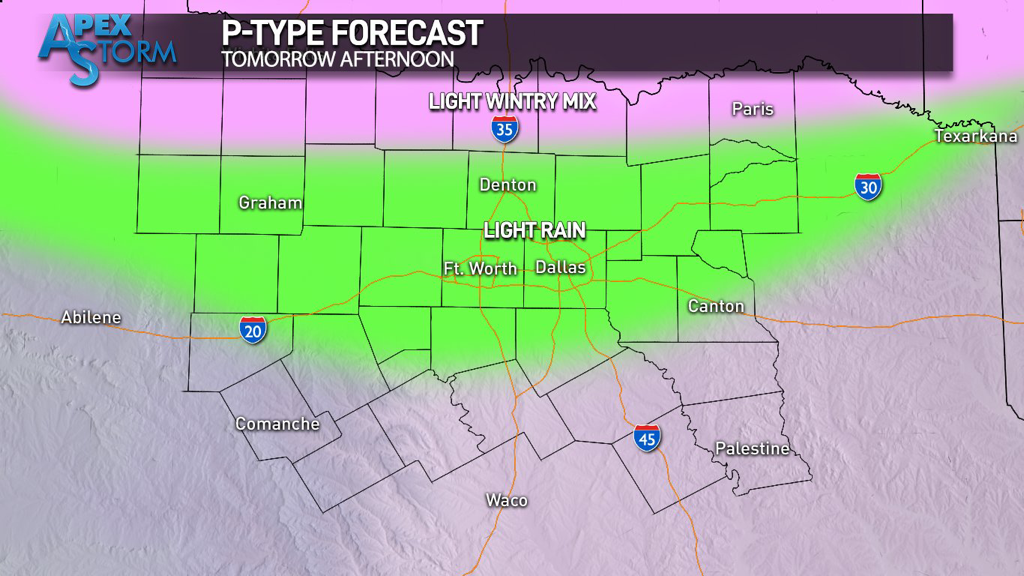 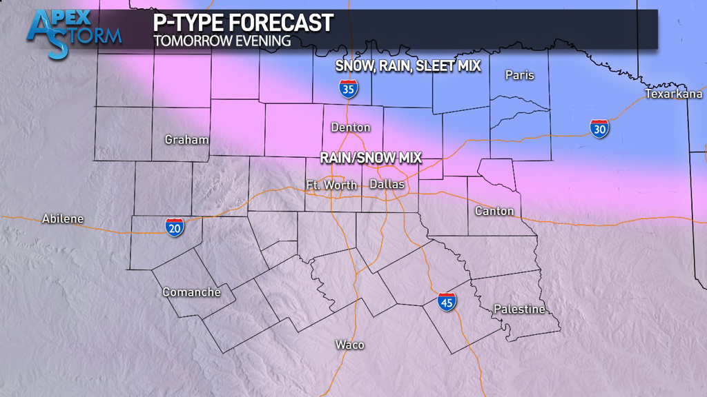 LOOKING FORWARD:
Wednesday will have clearer skies and begin the trend of warmer weather for DFW through the end of the week. Thursday and Friday will have seasonal temperatures with a ridge setting up over Texas. A small shortwave will bring the chance of precipitation overnight Friday that then gives way to even warmer temperatures in the 60s over the weekend. The presence of the upper level system will mean periodic clouds throughout the weekend as well. The next week should also have pleasant, seasonably warm temperatures as we head towards Christmas where an EPO dump might bring North Texas’s first good chance at a wintery system. Stay tuned, stay warm, and stay weather aware! -Colin Welty COMPLEX PATTERNS: Hey y’all, glad to be writing another blog post! We have a really uncertain few days ahead of us and this is the perfect opportunity to write about some of the weather North Texas will experience in the coming days. One of my favorite parts about winter in Texas is how multiple kinds of weather can occur, often on the same day, throughout the winter. This notion definitely stays true to the time ahead of us as well and leads many of us to ask: what will happen with the upcoming weather pattern? SHORT RANGE: Thursday brings the persistence of a sunny, seasonally warm day with plentiful amounts of blue skies and above average temperatures. However, there will be a noticeable change in winds, with gusts up to 20 miles per hour headed northward. These winds are a sign of the change in the weather pattern North Texas will be seeing. So, while the day will continue to be warm like most of the days this week have been, look for some noticeable breezes and the potential for a few clouds in the evening. Nightfall sees a typical drop in surface temperature, but it won’t be as wild as the temperature swings in the past few days (places like Waco saw a near 50 degree difference between the morning low and the daily maximum high on Wednesday) due to the increase in moisture from the active upper-level jet stream and a detached low pressure system. Rain chances increase as the night continues due to high levels of ascent, which should tap into the active jet and move eastward as Friday morning progresses. 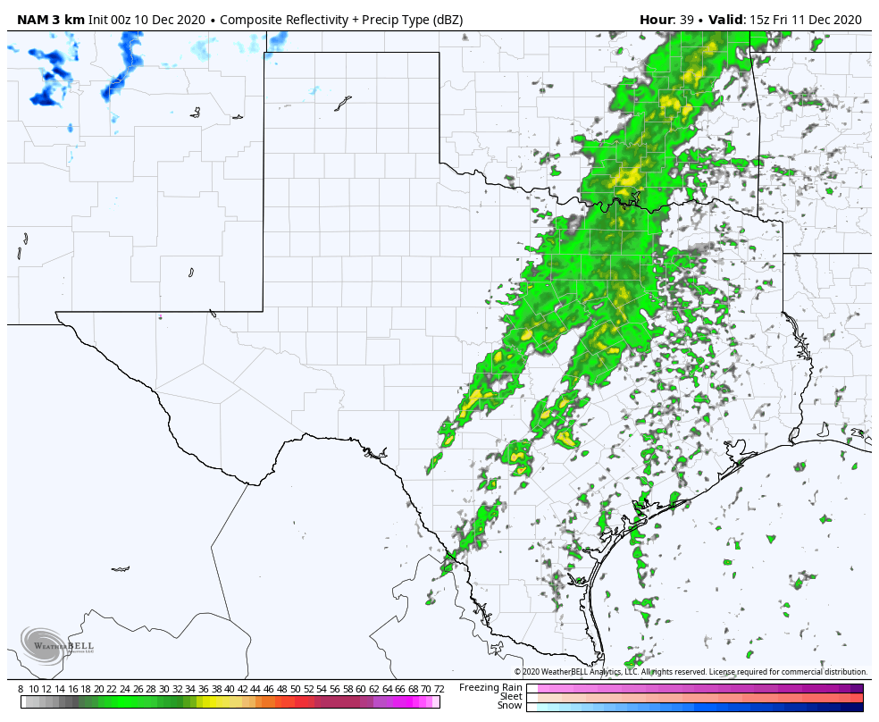 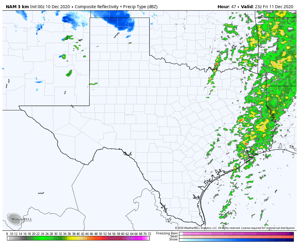 The 00z NAM showing model predictions for rainfall at 9 am and 5 pm on Friday. FRIDAY’S STORM POTENTIAL: As models have slowed the progression of the cold front over the past few runs, in addition to the new high resolution mesoscale model guidance, it has increased the potential for severe weather east of the metroplex midday Friday. While moisture is set to move out eastward midday as the front passes through DFW, ahead of the front in portions of NETX, the potential for lightning and thunder is considerable but still unknown. There is NO risk for tornadoes or even hail, but there is a chance for some lightning strikes as the afternoon begins. In addition, some model guidance supports pop up thunderstorms for DFW in the evening as well, with the potential for a squall line to develop behind the front. As the afternoon turns into evening, the potential for scattered thunderstorms increases. Strong storms are improbable but not impossible east of the metroplex. The new pattern, as a result of the upper level low, will bring much cooler and more seasonal weather with highs on Saturday struggling to break out of the 50s, even with clearer skies.  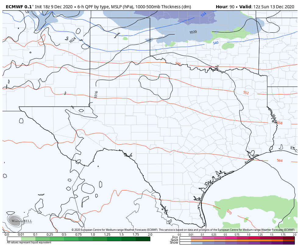 The difference between the Euro and Canadian model for potential weather on Sunday. Note the placement of the blue line—that’s upper level freezing line and indicates that the Canadian Model is showing a lower ULL than the Euro. FUTURE UNCERTAINTIES: I’ll admit, I don’t know what’s going to happen for Sunday. A fairly potent shortwave will move into the southern plains overnight Saturday into Sunday. While temperatures will decrease as a result, it’s more of a strengthening of the effects of the initial front on Friday, rather than a separate front. However, coupled with this shortwave is another upper level low that is capable of producing moisture and increases the uncertainty of the forecast. The uncertainty of the moisture potential and severe storm placement as a result of the speed and strength of the front on Friday also impact the significance of the shortwave over the weekend. Shortwaves like this are very hard to track from even a couple days out, meaning the placement of the low is extremely uncertain as of now and can vary by even a hundred miles. A low tracking upper level low moving through central Texas is much more favorable than a higher tracking upper level low that moves across the red river, because the temperatures that produce wintry mix or even snow are going to be found North of the low. The presence of the initial front on Friday makes this even more complex because a small change in timing or variance of temperatures by even two degrees could massively change the placement of the trough. In general, the global models are showing almost unanimous agreement on snow in Oklahoma and rain in Texas. So, as a result of the massive uncertainties associated with the complex, double upper level low setup, and the lack of high resolution guidance due to the proximity from the event, we are going on the conservative route and showing temperatures in the upper 30s overnight Saturday and in the mid 40s for Sunday. 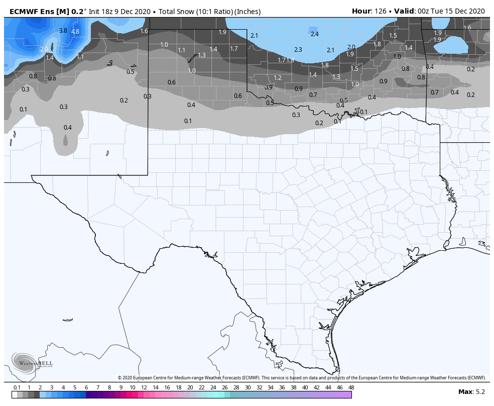 Latest Euro Ensemble Mean indicates North Texas snowfall isn’t out of the realm of possibilities. A wintry mix is, however, possible for the red river basin, given high moisture aloft. lt can’t be ruled out for DFW at this time, however, it remains unlikely given current model guidance. We will know more in the upcoming days.
For now, stay safe, stay warm, and stay weather aware! -Colin Welty |
Archives
April 2024
Categories |
 RSS Feed