
|
TODAY - As the ridge continues to build over Texas, our days will continue to look the same; hot and windy days with fair nights. The high this afternoon will be in the mid upper 90s. Not much change in the forecast tomorrow. We continue to forecast sunshine in full force with breezy conditions. Highs will be in the upper 90s. THE WEEKEND - Saturday will be the hottest day of the year so far with a projected high of 104-105, which could be our new record high, replacing our current record of 100, set in 1998. A cold front comes through Saturday evening, and we will mention the chance of a few isolated showers and thunderstorms along the front. I would not be surprised if we see a few strong to severe storms Saturday evening/night taking into account the daytime heating we will have. Places that do not see rain will likely see an increase of cloud coverage during the evening into the overnight hours. Heat levels cool down a bit with afternoon highs in the mid 90s. NEXT WEEK - Most of next week stays dry. However, an area of low pressure followed by a dryline will set up in West Texas. A complex of showers and thunderstorms may develop along that boundary Tuesday afternoon that could move eastward towards DFW. A few isolated showers and storms will be mentioned. Highs will stay in the upper 90s to low 100s with more sun than clouds. See the Texas Weather Discussion Video for more details. 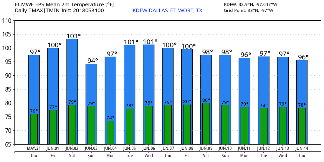 TROPICS - All is quiet in the Atlantic Basin, and tropical cyclone development is not expected within the next two to five days. Tomorrow marks the first day of Meteorological summer as well as the start of the 2018 Atlantic Hurricane Season.
HOT, DRY WEATHER CONTINUES - Temperatures in some spots are already in the 80s this morning. As stated in the last blog post, today will be no different from recent days; we will continue to mention hot, breezy days with fair nights. Highs will be in the upper 90s today. The same forecast sticks with us for the rest of the week. Highs will be at or near 100 degrees with lots of sunshine. The average first 100 degree day in DFW is July 1. THE WEEKEND - Saturday will be very hot with highs in the 100-105 degree range. If DFW can surpass 100 degrees, that temperature will be established as our new record high for June 2. Our previous record is 100 degrees set in 1998. A cold front comes through Saturday night/early Sunday morning mostly in dry fashion. We still could see a stray thunderstorm try to develop in the morning. Highs will still be in the upper 90s. NEXT WEEK - Expect nothing but fair nights and hot, breezy days with lots of sunshine with highs in the upper 90s to low 100s. See the Texas Weather Discussion Video for more details. 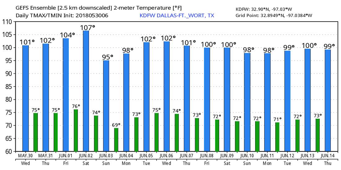 Temperatures this morning are in the upper 60s-low 70s range across the region this Tuesday morning deep in the heart of Texas. Our weather today will be no different than recent days; hot days followed by fair nights with afternoon highs in the upper 90s with some places reaching 100 degrees. WEDNESDAY THROUGH THE WEEKEND - Wednesday, May 30 will likely be the first 100 degree day of the year for DFW, two days before the start of Meteorological Summer. The earliest 100 degree day was May 30, 1928 and the average 100 degree day in DFW is July 1, so we are about one month early. The rest of the work week will be dry with highs in the low triple digits. We will likely see record temperatures this Saturday with DFW high being 104-105. The current record for June 2 is 100 degrees, set in 1998. We do cool down a little bit on Sunday, but highs will still be in the upper 90s with some places reaching 100 degrees. NEXT WEEK - Look for highs mostly at or just above 100 degrees for most of the workweek. Be sure that you are practicing heat safety whereever you go. 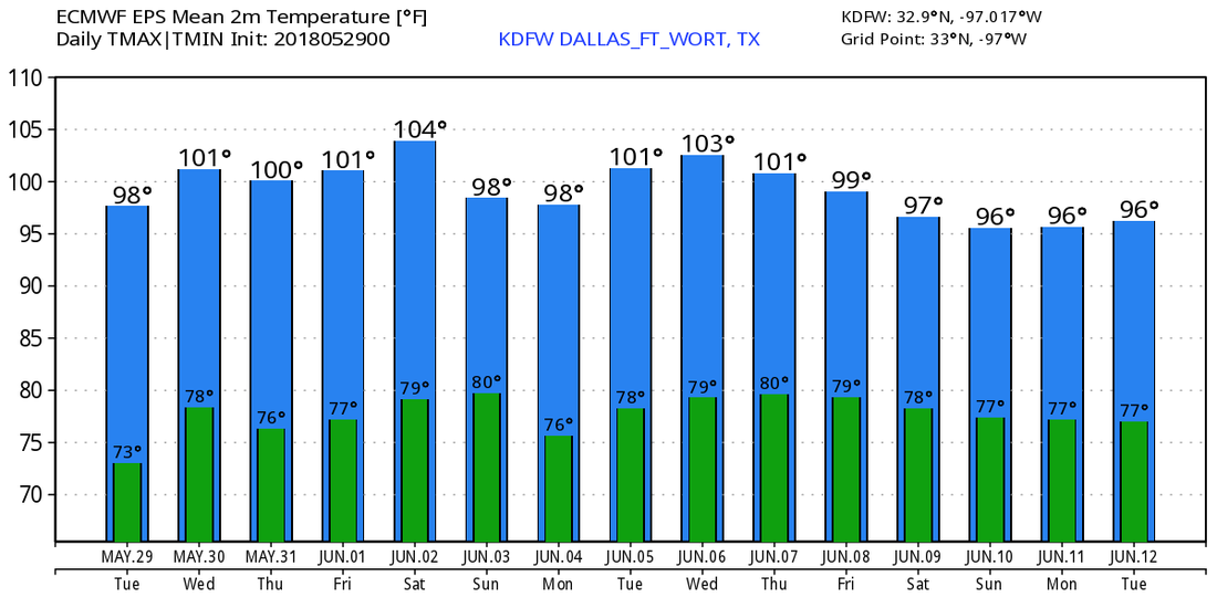 ALBERTO - This storm is a subtropical depression that is located in Central Alabama this morning. It will continue to progress to the northwest, producing heavy rain and the potential for a couple of isolated tornadoes at times. An additional 4-6 inches of rainfall can be seen in central Alabama during the day, but those amounts will lessen as Alberto weakens and moves to the north. See the Texas Weather Discussion Video for more details. 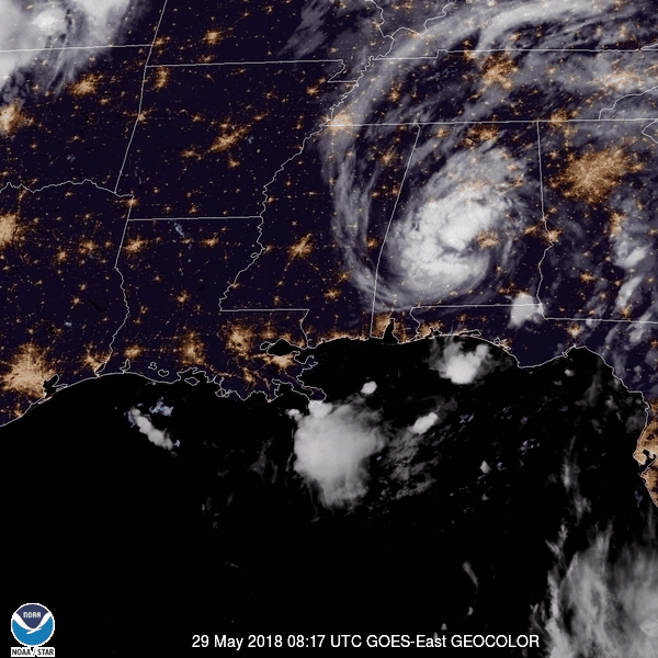 RADAR CHECK - Heavy rain and thunderstorms continue to the east of I-35 with the heavier storms generating lots of frequent lightning accompanied by heavy rainfall. These storms will slowly fade during the evening hours.  An outflow boundary is also moving ahead of the complex, which is causing a shot of cool air in some parts of the area. Points to the north of the metro are in the low 70s due to rain-cooled air. 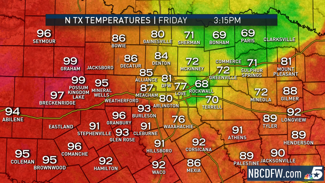 We get a break from the rain this afternoon with sunshine breaking out at times. More development is possible overnight as a complex of weakening severe storms will likely move into the region past 10:00p. By that time, the main threat will be hail and gusty winds at times. MEMORIAL DAY WEEKEND - Nothing worth noting in the Texas weather department other than mostly skies and afternoon highs in the mid 90s. We will begin the process of a big warm up and summer time heat. NEXT WEEK - Get ready for a big warm up in temperatures this week as an upper high builds over the south-central part of the country. This will lead to the hottest temperatures so far this year, which will include some triple-digit heat. The earliest triple-digit day for DFW could be Wednesday, May 30, pretty close to the record high of 102 set back in 1985. TROPICAL UPDATE - The NHC named Subtropical Alberto earlier this morning, and is expected to officially become a tropical storm within the next 24 hours. This will not be a storm that will affect Texas. 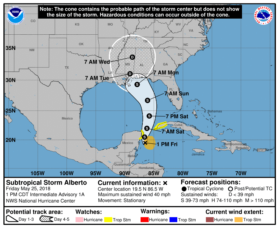 This system will most likely remain a minimal tropical storm and will not become a hurricane. The main threat from this system will be heavy rain, not wind. The National Weather Service in Mobile has already posted Flash Flood Watches for parts of the coastal cities and towns, a coastal flood watch as well as a high surf advisory for adjacent areas, calling for about 6 to 12 inches in rain totals. As always, keep in touch with the website for more information regarding the tropical storm threat for the coastal states in the Gulf. See the Texas Weather Discussion Video for more details.  SUB-MOIST AIRMASS - This is about the time of year where moist unstable air is in place for much of the Deep South for late May through early September. As long as there is something to weaken the ridge in the southern plains, there's a good chance that at least some of that moisture could feed into Texas. But for the most part, most days usually stay dry and sunny in summer for Texas. Back on the moist airmass case, since we don't have it as bad as the Deep South, we will continue to mention a day mixed with sun and clouds with random isolated showers and thunderstorms. Any showers or storms should remain "few and far between". The heavier storms will produce lightning at times, so no threat of severe thunderstorms. Highs will mostly be in the low 90s with a mixture of sun and clouds. MEMORIAL DAY WEEKEND - Not much change. More sun than clouds, with rain chances diminishing during the weekend. However, we must keep an eye on the Gulf of Mexico for any tropical development as global models continue to suggest an area of low pressure. The European Model shows the center of the low near the Mississippi/Louisiana Coast Saturday afternoon, and it keeps it in the deep south through Monday. One way or another, this looks like better rain chances for the southeast, meaning that this will most likely not impact Texas. 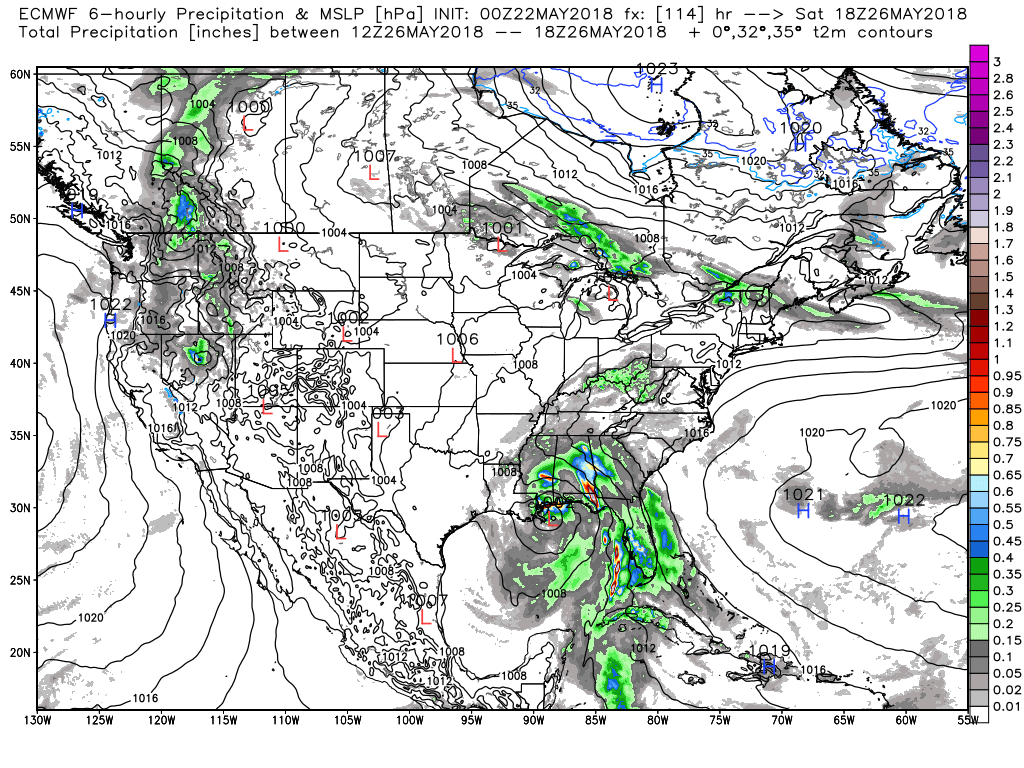 NEXT WEEK - Not much to suggest any change to the weather pattern next week. Ridging will still remain in place over the plains, meaning and showers and storms will be few and far between with more sun than clouds. Highs will be in the mid 90s. See the Texas Weather Discussion Video for more details. 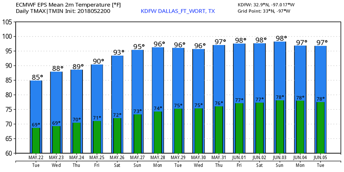 TODAY - This day will be no different than any of our recent days. We will forecast mostly dry conditions with only a couple of showers around. The sky will be mostly sunny with afternoon highs in the low to mid 90s. We will have the same, consistent forecast tomorrow as well. Very warm days with mostly sun. The record high for May 18 is 96 degrees. We are forecasting a high just at or below 95 degrees. THE WEEKEND - Not much change. We continue to stay dry through the weekend with more sun than clouds. Highs will continue to be in the low 90s. We will start each day in the low 70s. I know there is usually lots of stuff going on leading up to ceremonies, graduation, parties, etc. on the weekend, so here are a few points about the weekend and upcoming week. *Most places will continue to remain dry through most of next week as well with afternoon highs in the low 90s. *Any showers or thunderstorms that develop will be few and far between. *The chances of rain will be very slim to none for a while. *Expect more sun than clouds. We are merging into a summer-like pattern with mild nights and very warm afternoons with mostly sun with occasional clouds and a few pop-up showers. See the Texas Weather Discussion Video for more details.  TODAY - The sky will feature a mix of sun and clouds, and with that we will continue to forecast spotty, afternoon showers and thunderstorms, words you hear in the summertime in the Deep South. The chance of any one spot getting wet is in the 10 percent range, and temperatures should be in the same levels as yesterday. Some places will see a high of 90 degrees, most will see a high a couple of degrees lower. We will warm up tomorrow as well with more sun than clouds. Highs warm to the low 90s. We will continue to forecast occasional showers, but no organized severe weather is expected any time soon. FRIDAY AND THE WEEKEND - We dry out by Friday with mostly sunny conditions with near record highs. The record high for Dallas on May 16 and 17 is 96 and 97 degrees, set in 1956 and 2006. Highs will be in the mid 90s on Friday and Saturday. We will be a couple degrees cooler on Sunday with highs in the low 90s with mostly sunny skies. NEXT WEEK - Looks like most of next week will be filled with fair nights and very warm days ahead. Highs will be in the mid 90s and lows in the mid 70s. No signs of any severe weather trouble for at least the next ten days. See the Texas Weather Discussion Video for more details. 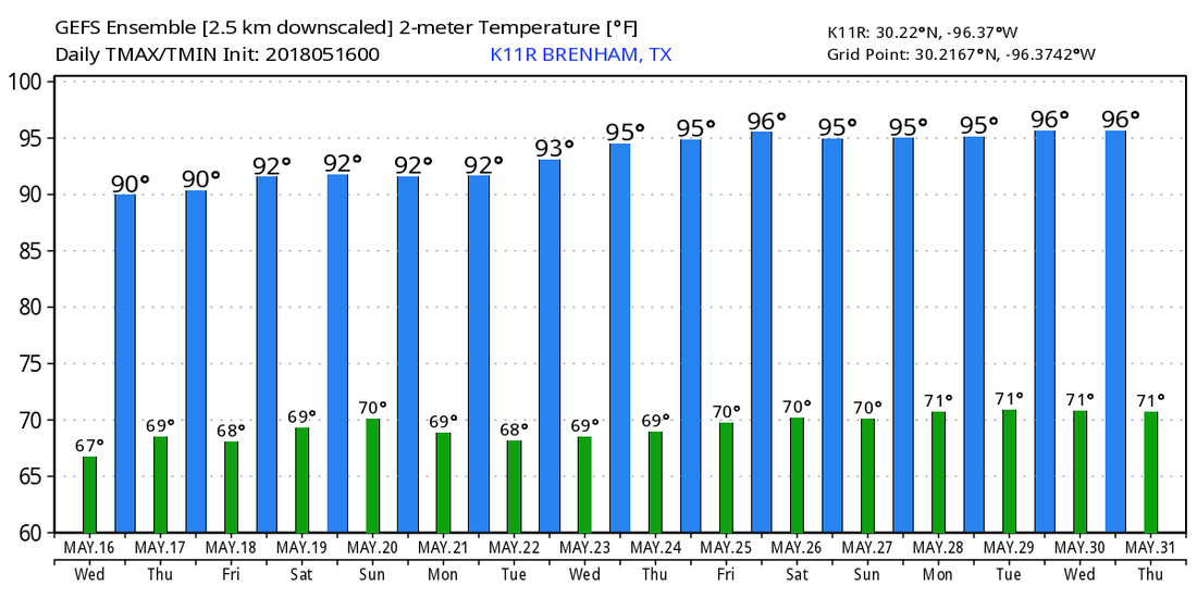 ANOTHER MILD START - Temperatures are mostly in the mid 70s this morning across the North Texas region. We will continue to be very warm today with afternoon highs in the upper 80s to low 90s. Nothing on the radar for the DFW metro though. TO THE NORTHEAST - A cluster of strong storms over parts of the Texas/Oklahoma border. These storms are moving to the east.  We will continue to mention the chance of random scattered showers and thunderstorms at times during the afternoon and evening. Some of those storms could turn marginally severe with gusty winds and large hail the dominant threat. We do note that the SPC has a "marginal" risk of severe storms defined for parts of North Texas.  Otherwise, we will forecast partly cloudy skies with highs in the upper 80s. TOMORROW THROUGH FRIDAY - We will mention the chance of a cluster of strong thunderstorms during the pre-dawn hours on Wednesday, before turning dry for the remainder of the week. The sun comes out in full force on Friday, and we should be dry with highs in the low to mid 90s throughout the latter half of the week. THE WEEKEND - Expect another mild weekend ahead with sunshine in full force. Highs will be at around 95 on Saturday, only dropping to about 93 on Sunday. It will be the hottest weekend so far. NEXT WEEK - Moisture from the disturbance in the gulf gets locked inland, and we will mention the chance of scattered showers and thunderstorms as that moisture overspreads the region. Highs will remain in the middle 90s with a mix of sun and clouds. The latter half of next week looks dry. See the Texas Weather Discussion Video for more details. 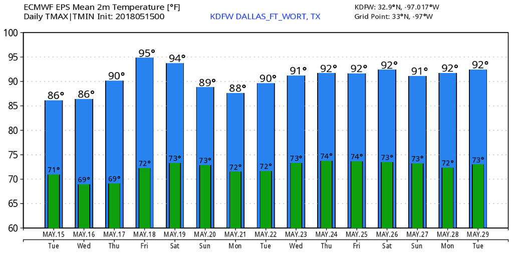 MILD START - Temperatures are mostly in the 70s across the great Southern Plains this morning. Expect a mix of sun and clouds with afternoon highs just at or below 90 degrees with a southerly wind. We will introduce a very small chance of an isolated shower today with any clouds that can dump rain, but most places will stay dry. TOMORROW THROUGH FRIDAY - We will continue to mention the increasing chance of scattered showers and thunderstorms with an approaching surface boundary from the north. We remain dry on Wednesday with sunshine in full force, but we bring back another chance of showers and storms on Thursday. We stay dry on Friday with a mix of sun and clouds. Highs will be near 90 degrees on Tuesday, warming up to the mid 90s on Friday. THE WEEKEND - Expect the hottest weekend so far this year again. Sunshine will be in full force on both days with afternoon highs in the mid 90s on both days. NEXT WEEK - It looks like the early part of next week looks dry as well with a mix of sun and clouds with afternoon highs in the low to mid 90s. 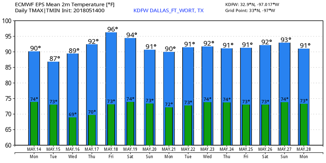 ANOTHER VERY WARM OUTLOOK - We've had a very hot week across the North Texas region with highs mostly in the upper 80s and low 90s with very breezy conditions. We should continue that pattern today with highs in the upper 80s again today with windy days. THE WEEKEND - Not much change from previous forecasts. There is high confidence that we will be in the 90s this weekend as the hot, dry spell continues. Sunny, windy days, fair nights with highs in the low 90s tomorrow and Sunday. It should be the hottest weekend so far this year as we gear up for summer. NEXT WEEK - We should stay dry for Monday and Tuesday with highs in the low 90s, but the chance for scattered showers will increase in the middle of the week as a trough develops to our west. Highs will still be in the upper 80s/low 90s, though. See the Texas Weather Discussion Video for more details. 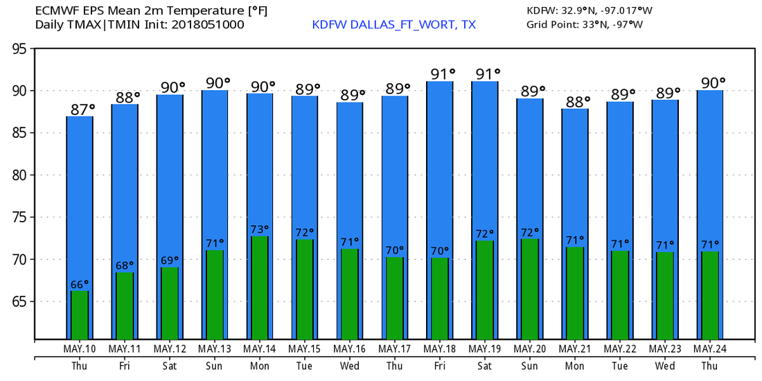 SUMMER PREVIEW CONTINUES - A very warm, windy, and mostly dry pattern will continue through the weekend for much of our region. We could see a shower or two mainly for areas along the Red River, but 99% of the region stays dry. Highs will be in the upper 80s to near 90 for today and tomorrow, warming up to the 90s for the weekend, making it the hottest weekend thus far. One of our writers made the bold prediction that the first 100 degree day for DFW will be June 14. Not to be taken seriously, but lets see how far he goes! I'm also starting to think that we skipped spring and went straight to summer... NEXT WEEK - We may introduce the chance for some decent rainfall next Thursday with a slow moving surface front, front nothing too widespread and no severe weather problems. The better rain chances will remain to the east as a disturbance from the Gulf of Mexico lifts north, and a trough develops in the vicinity. See the Texas Weather Discussion Video for more details.  ANOTHER MAY MORNING - Once again, temperatures are mostly in the mid to upper 60s across the region this morning. Today will be another very warm day with abundant sunshine with highs just at or below 90 degrees. TODAY THROUGH THE WEEKEND - Not much change in the weather situation in North Texas through the weekend. We stay dry with very warm days and fair nights. Highs will stay in the upper 80s to low 90s with breezy conditions and abundant sunshine. NEXT WEEK - Our current pattern stays the same for next week with fair nights, very warm days with highs in the upper 80s to low 90s. We could see an isolated shower or two pass by during the middle of the week, but 98% of the region stays clear from any rain. Also no signs of any severe weather issues across the region for the next ten days. See the Texas Weather Discussion Video for more details. 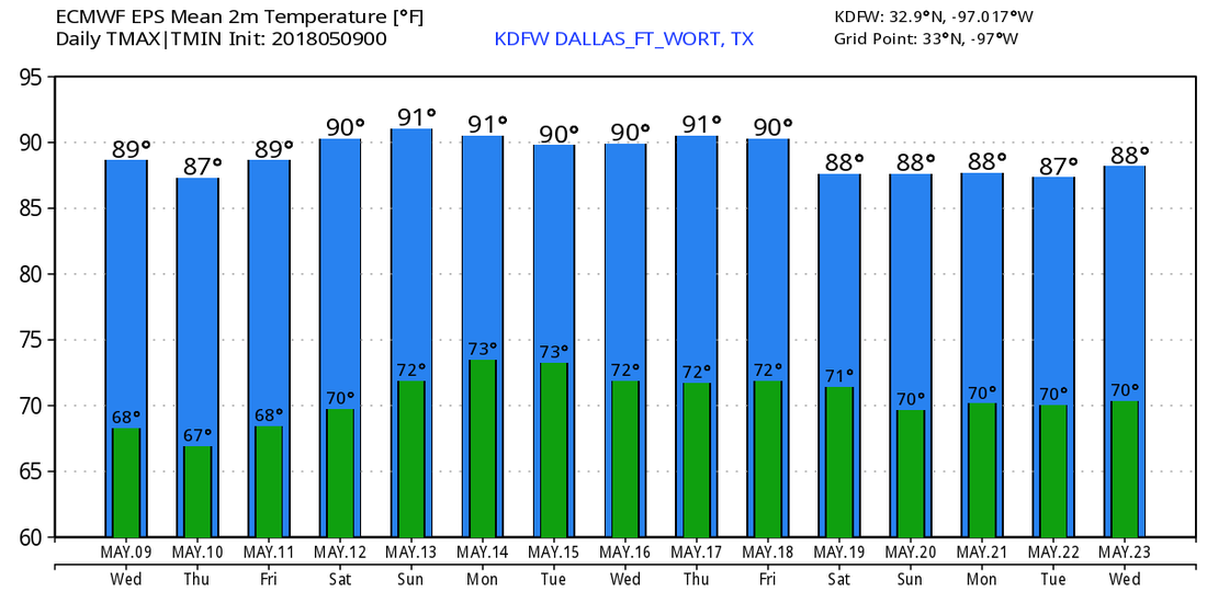 QUIET MORNING - We are starting Tuesday morning off with temperatures in the mid 60s and low to mid 70s in the metropolitan areas. With a good supply of sunshine and a few clouds, we continue to project a high in the low 90s. Very warm, dry weather will prevail tomorrow and Thursday... the sky will remain sunny with highs just at or below 90 on both days. Rain stays well off to our north. FRIDAY AND THE WEEKEND - The calm pattern prevails through the weekend as the main storm track stays well to our north. We continue to project mostly sunny days with fair nights and highs in the mid to upper 80s. Isolated thunderstorms may develop on Sunday or early next week with a trailing cold front, but most places will stay dry due to the ridge. NEXT WEEK - A surface front could bring a chance of shower and maybe a thunderstorms during the middle of next week, but severe weather is not expected and most places will remain dry. The mild pattern will continue to prevail through most of next week. See the Texas Weather Discussion Video for more details. 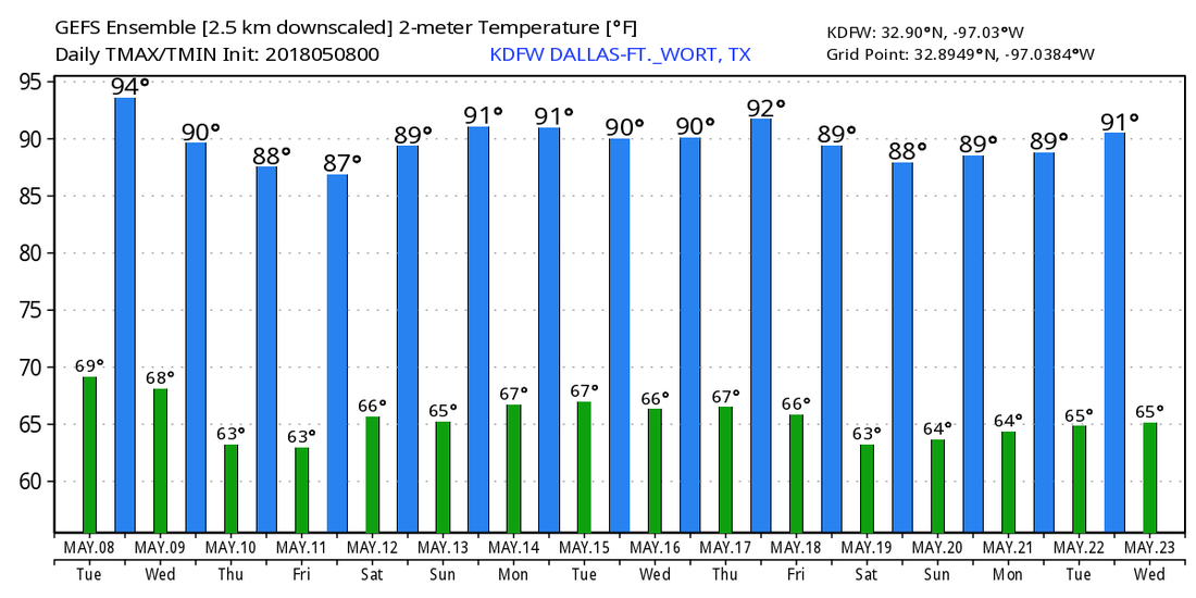 COMFORTABLE START - Temperatures range from mid 50s in Arlington to around 70 degrees in Dallas Love Field this morning. Look for a big warm-up today; with breezy conditions and sunshine in full force we will likely see our first 90 degree day of the year this afternoon. Tonight will be clear with lows in the mid 60s. REST OF THE WEEK - A building upper ridge over the western third of the nation will bring the warmest weather thus far this year in Texas. Look for highs in the low 90s tomorrow, Wednesday, Thursday, and upper 80s on Friday. Sunny days, fair nights, and no sign of rain for the workweek. THE WEEKEND - A few clouds start to roll in here by Saturday, but we will still be hot. We will introduce a chance of scattered showers and thunderstorms on Sunday with a trailing cold front, despite the GFS showing no rainfall on Sunday. No "wash-out" or severe weather is expected. Sunday's high will be in the mid 80s with a mix of sun and clouds. NEXT WEEK - The early part of next week looks very warm and dry as the upper level ridge rebuilds.... See the Texas Weather Discussion Video for more details. 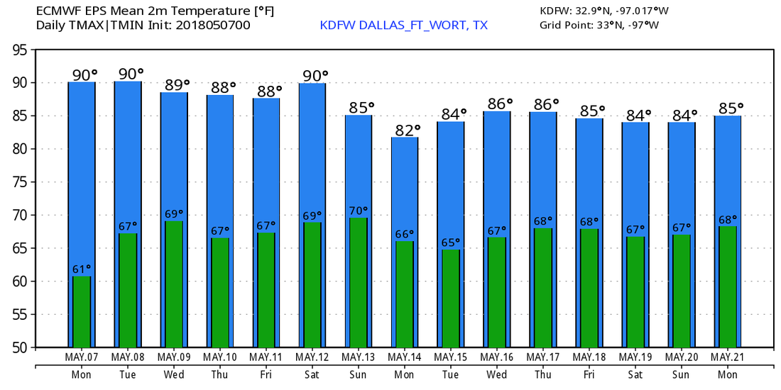 RADAR CHECK - Rain and thunderstorms continue to move to the east and northeast towards DFW this morning...  A cold front is due in here later this morning, which means that widespread rain and thunderstorms will persist throughout most of the morning and afternoon. Be sure you prepare by taking an umbrella to work or school as you head out this morning. Be careful for wet spots on roadways too. Most of North Texas is in the low 70s this morning, but with the cold front coming through, temperatures will go the wrong way today. We will start in the low 70s, and fall to the mid 60s during the afternoon. Don't expect much sunshine if you don't see rainfall. Rain amounts should stay in the 1/2-1 inch range. THE WEEKEND - Once the cold front moves through, we immediately warm back up on Saturday with highs in the low 80s with sunshine in full force. We stay pleasant during the weekend with highs in the mid 80s with overnight lows in the low 60s under a fair sky. NEXT WEEK - Looks like the week full of EOC's and AP testing will be mostly dry and mild with afternoon highs in the upper 80s under a sunny sky. There is a chance that some places could see 90 for the first time this season, but that's way too far out to predict. See the Texas Weather Discussion Video for more details. 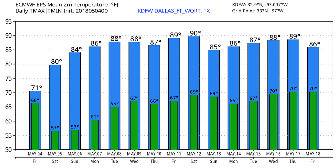 STORMS THIS MORNING - To our northwest, a mini QLCS is moving through parts of northwestern Texas near Wichita Falls, where two tornado warnings have been posted just to the north of the city. To our north, some non-severe storms for our counties to our north continues to move eastward.  It is also worth mentioning that a severe thunderstorm watch has been posted for our three northernmost counties (Grayson, Montague, Cooke) until 11AM this morning. Damaging winds and large hail can be expected with any severe storm that develops. Brief, isolated tornadoes can't be ruled out embedded in the main line. In North Texas, we are quiet now with temperatures in the low to mid 80s, but it may get noisy as we head into the early afternoon. A cluster of strong to severe storms is likely around 11AM into noon, tapering off during the evening hours. Be aware that all modes of severe weather will be possible, including the potential for gusty winds and large hail. The tornado potential is very low, but not zero. Be sure to stay tuned to the website and use our interactive radar for more details. We will still be wet tomorrow from the moving cold front, but there is no severe weather risk defined for North Texas after today. Rain is likely again during the morning and afternoon, and will taper off during the evening. Again, no severe weather is expected, just a classic rainy day is expected. Maybe some thunder, but that's really about it. Highs will be in the mid 70s as a result of that front. THE WEEKEND - Once the storm system lifts off to the east, we clear to pleasant conditions during the weekend. Highs should be in the upper 70s on Saturday, warming up to the mid 80s by Sunday. Each day will feature a sunny sky. NEXT WEEK - An upper ridge will build over the central part of the country, and that should keep us dry for most of the week. Highs should be in the mid 80s each day with a sunny sky. See the Texas Weather Discussion Video for more details. 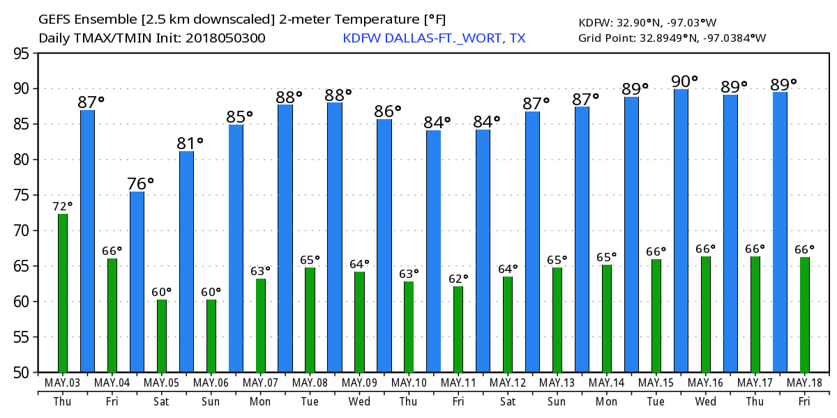 MILD START - Despite some morning drizzle out on the radar, temperatures are well into the low 70s this morning as anticipated. The average high for May 2 is 81 degrees in Dallas. Highs will be well into the mid 80s again today with cloudy skies. Scattered showers and thunderstorms could develop during the afternoon and evening hours. An upper trough in the western side of the country will bring the chance of widespread severe storms with very large hail, damaging winds, and a few tornadoes, some of which could be on the strong side from Texas through parts of the Midwest. The highest tornado probabilities are maximized over portions of Western Oklahoma and Kansas this time. 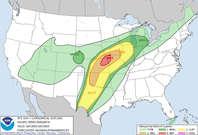 For North Texas, we might see some random showers and thunderstorms that could turn marginally severe, but that's really about it. Our main focus for severe weather will be Thursday as the cold front moves to the east. We do note that the SPC has all of North Texas under the standard “slight” risk for severe storms tomorrow. 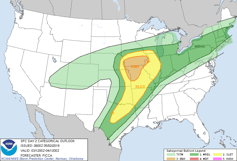 A batch of showers and thunderstorms will be possible during the pre-dawn hours before a cluster of strong to severe thunderstorms move in during the afternoon. These storms could produce large hail and damaging winds, maybe even a couple of weak tornadoes given a few strong hodographs. If you don’t see anything, tomorrow will be mostly cloudy with highs in the low 80s. FRIDAY AND THE WEEKEND - We will still continue to mention the chance of rain and thunderstorms during the day, but severe weather will not be an issue. Rain amounts should be in the one and a half inch range by Friday. Highs will only reach the upper 70s due to cold air advection from the cold front. We will warm up through the weekend with a mix of sun and clouds, and highs should be in the 80-85 degree range. NEXT WEEK - After an active week of severe weather, next week should be mostly dry and sunny with afternoon highs in the mid 80s. See the Texas Weather Discussion Video for more details. 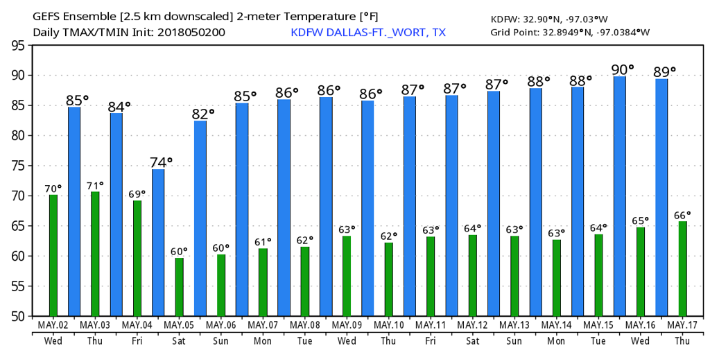 SPRING-LIKE MORNING - It is starting to feel more like spring deep in the heart of Texas this morning. Temperatures are in the upper 60s to around 70s across the region, and today should be mostly cloudy and very windy, similar to yesterday. We will mention the chance of a stray shower or two, but not very likely and most places will stay dry. Highs will be in the low 80s. Tonight will be mostly overcast with lows in the upper 60s/low 70s again. REST OF THE WEEK - A upper-level trough will reach down to the southwestern part of the nation for most of the week, which means we will most likely see some sort of severe weather threat during the middle of the week. Despite a major severe weather threat three hours to the north of us, we forecast only a few scattered showers and storms on Wednesday with highs in the mid 80s. A few storms might end up turning severe, but that is really about it.  Thursday will be our best day in terms of seeing localized severe storms as the cold front progresses eastward. Of course, the storm system will have weaened a bit, but we still need to mention the risk for severe weather. TIMING - Showers during the pre-dawn hours are likely, which may affect the morning commute to work and school. We get a break from the rain during the morning before a cluster of strong to severe storms develop in West Texas and move to the east. They should be in the region by about lunch time. THREATS - The main threat that comes out of this system comes from large hail to damaging straight-line winds. Some models suggest that a couple of tornadoes can't be ruled out as well. For those that don't see anything on Thursday, it should be mostly cloudy and dry with afternoon highs in the low 80s. FRIDAY AND THE WEEKEND - We generally clear out for the weekend, though we still could see a few stray showers during the weekend, but most places stay dry with highs in the low to mid 80s. Winds should turn out generally calm, and should be quite comfortable. The sky will be sunny. NEXT WEEK - It looks like most of next week will remain dry and pleasant with highs mostly in the mid 80s with sunshine in full force. See the Texas Weather Discussion Video for more details. 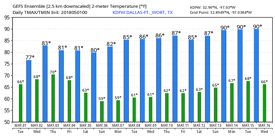 about the authorDonovan Neal is one of the most trusted and recognized meteorologist and storm specialist in his community and school. He currently holds two Advanced Storm Spotter Training Certificates and is a NOAA Weather-Ready Nation Ambassador. |
Archives
April 2024
Categories |
 RSS Feed