
|
EARLY MORNING WAKE-UP CALL: After midnight, a lone thunderstorm out near Wichita Falls began making a turn to the south, cycling as it made its way to the metroplex. By the 4:30-5:30 timeframe, the storm produced frequent cloud to ground lightning, some damaging winds, and golf-ball sized hail. The NWS Office in Fort Worth measured 1.5" hail at 4:26 am. 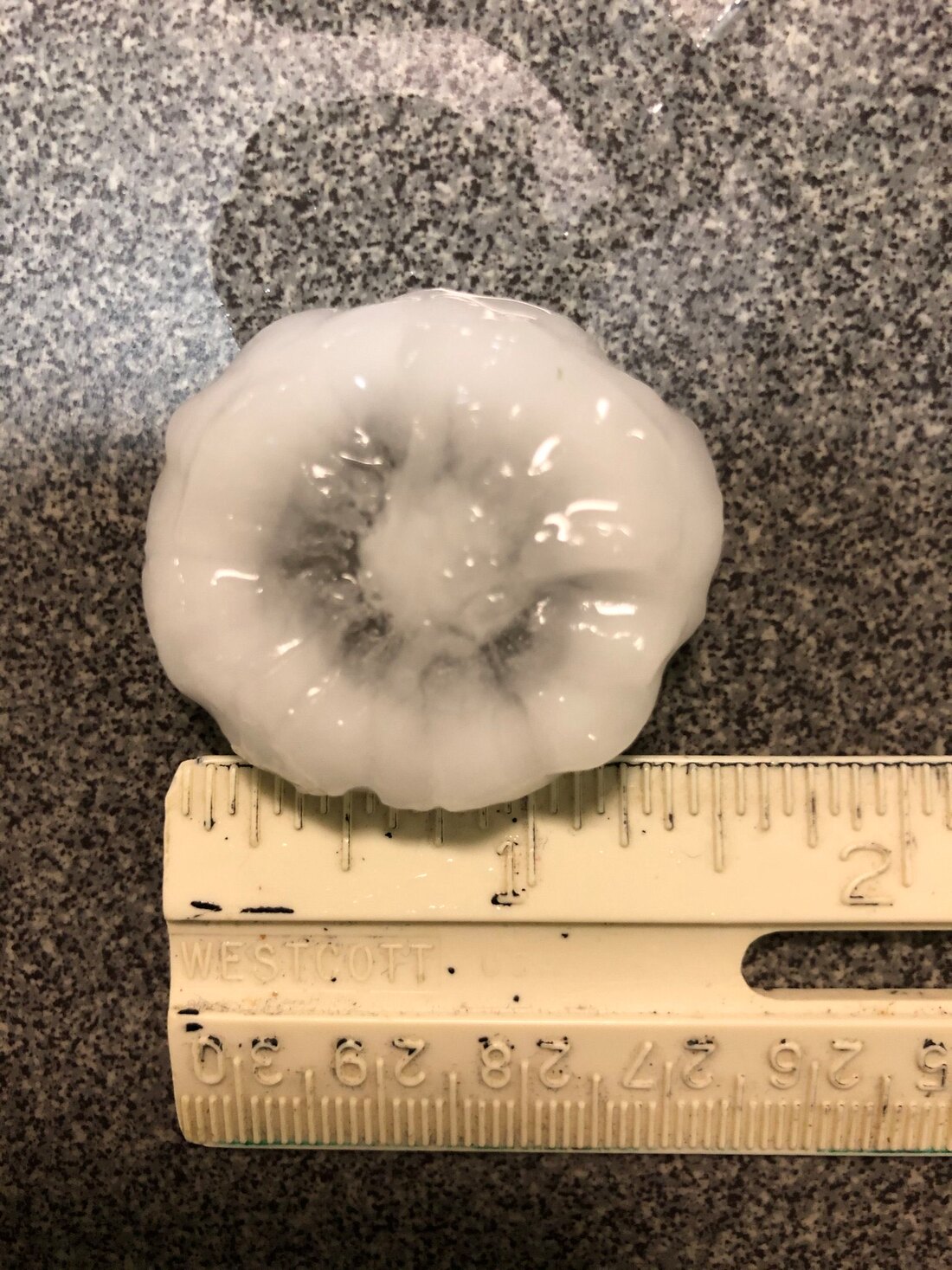 The storm has weakened and has subsequently continued to push to the east/southeast. We will remain partly sunny and dry for at least the early afternoon hours, with highs in the upper 80s to low 90s. SEVERE WEATHER LIKELY OVERNIGHT: A rather unstable airmass is expected to hold and move south this evening into tonight, and high resolution data suggests rapid development of severe thunderstorms at around sunset just to the south of Wichita Falls. SPC has issued a wind-driven "moderate risk" (level 4 of 5) of severe storms for parts of northeast Texas and East Oklahoma. The rest of North Texas is surrounded by an "enhanced risk" (level 3 of 5) of severe storms, extending down to Central Texas. UPDATE: AS OF 11:30 TODAY, DFW HAS NOW BEEN ADDED TO THE MODERATE RISK OF SEVERE WEATHER. THE RISK OF SIGNIFICANT WIND GUSTS AND VERY LARGE HAIL IS INCREASING. 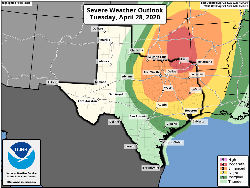 TIMING: Storms will likely develop near Wichita Falls after 7PM and move southward through the region overnight. The broad window for severe storms in North Texas will be from 8PM to 7AM tomorrow morning. The focused window will be from 10PM to 4PM through the metroplex.
THREATS: Any storm clusters that form during the early stages will have the possibility of becoming quite severe, posing the threat of very large hail (up to the size of tennis balls), damaging winds, and tornadoes. Any clusters will very quickly congeal into a QLCS (quasi-linear convective system), mainly posing the risk for damaging winds, some up to hurricane force gusts of 80 mph or more (remember, damaging straight-line winds can produce tornado-like damage). The highest tornado probabilities will be focused in the northeast corner of Texas and extreme southeast Oklahoma. RAINFALL: Rain amounts of around 1-1.5" inches is possible across the region, with isolated higher amounts. Some flooding is possible with torrential rainfall. CALL TO ACTION: Be sure to have multiple way of receiving warnings during the overnight hours (don't rely on a siren!!!). In your safe place, make sure you have helmets for everyone in your family. If you are in a mobile home, know your location of a site built-shelter, and how to get there quickly. This is the day to treat severe thunderstorm warnings very seriously. Severe thunderstorms can and occasionally produce tornadoes and tornado-like straight line wind speeds. Make sure your NOAA Weather Radio is on overnight, so it can wake you up if you are sleep while these storms are coming through. Also, make sure you are in our text-messaging system (text @apexstorm to 81010). Donovan Neal Owner - ApexStorm After a nice Saturday, a continued nice day is expected today with highs in the lower 80s expected with abundant sunshine. A few more clouds will be possible later this afternoon, but dry weather is expected. Tomorrow overall will remain fairly uneventful, but a decaying area of showers and storms will dive out of Oklahoma early tomorrow afternoon and may set up an outflow boundary somewhere in North Texas. This may allow for a very low storm chance, however no severe weather is expected. Skies will be partly cloudy with highs in the low to mid 80s. A few storms may develop N/W of the region tomorrow evening, and could make a run at our western/northern zones tomorrow night. At this time, severe weather is not expected as weakening is likely. Lows will remain in the upper 60s. Tuesday is shaping up to be an active severe weather day across parts of the state. While most of the day will be dry, a dryline will sharpen out to the west and will be the focus (along with a cold front in Oklahoma) for thunderstorm development. There are uncertainties about a capping inversion aloft preventing storm initiation, however some models (incl. Euro) have shown rather explosive supercellular development just west of I/35 late afternoon on Tuesday and moving eastward into our area during the early evening hours. 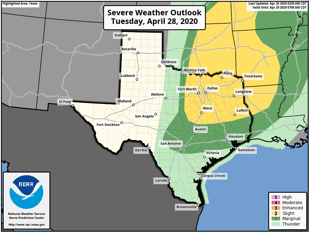 The Storm Prediction Center has already outlined much of the area in a "Slight Risk" for severe weather on Tuesday for storms capable of very large hail, damaging winds, and a few tornadoes. Remember, the initial threat of severe weather is conditional, but if storms develop they could be rather intense. 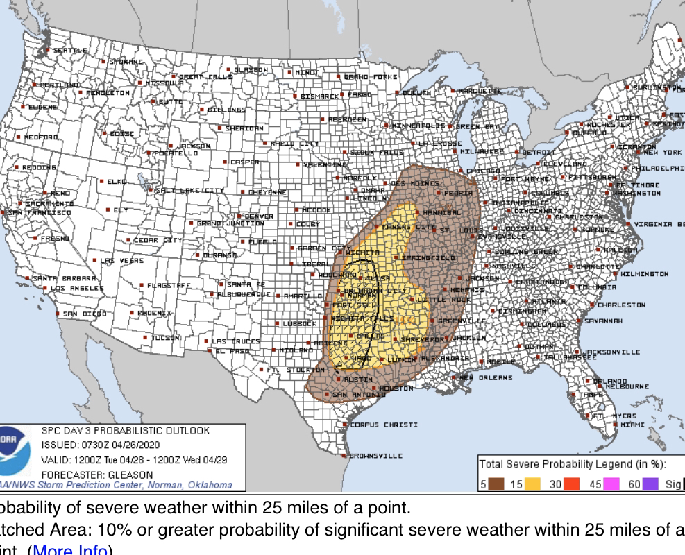 Notice the area inside the black circle (includes much of North Texas, including DFW) where the SPC has concerns for significant severe weather. (hatched risk) We are closely monitoring this.
Tuesday afternoon and evening isn't our only risk of storms. As a cold front slides in during the early overnight hours, an additional area of storms could develop. The best chance will be along and east of I/35 where better bouyancy and moisture remains. These storms could also be severe, primarily with damaging winds and a low tornado threat. Large hail still isn't ruled out with these storms. The rest of the week will be much calmer but remaining warm with highs in the 80s. Our next storm system will approach by next Sunday, and increasing southerly flow could shoot temperatures into the 90s with storm chances increasing, especially into early next week. Given the climatology, severe weather would certainly be in the realm of possibility. However, this is a week out and too many of uncertainties exist to get into any sort of detail. Have a great Sunday! Logan Shipley THIS AFTERNOON: It warmed very nicely to the mid 70s around lunch time! We will continue to see the temperature warm to the low 80s during the late afternoon and evening hours. THREAT OF SUPERCELLS TOMORROW: Let's just preface this blog by saying that this is the most serious threat of severe weather we have had in recent years. We saw what has been going on the past couple of Sunday's in Dixie Alley and Mississippi, and knew that our time was inevitably coming. So, here we are. Another vigorous spring weather system will impact the Ark-La-Tex and Piney Woods region tomorrow afternoon and evening, with the threat of tornadoes, very large hail, and damaging winds. SETUP: The mid-level jet will become coupled with the low-level jet by the afternoon and evening hours, especially after sunset, creating a favorable combination of lift, shear, and helicity for potentially strong tornadoes and very large to perhaps giant sized hail. The greatest probabilities for a localized episode of tornadoes is forecast from south-central Oklahoma through much of the North-Central Texas in the greatest threat of the "enhanced risk" area. In addition to the tornado risk, very large to giant sized (golf ball sized or larger) hail and wind damage will like be likely across a large part of the Ark-La-Tex region tomorrow afternoon and evening. The threat for damaging winds is expected to increase as a mesoscale convective system (MCS) moves eastward across East Texas overnight, eventually into Louisiana and Arkansas by Thursday morning. An hour ago, the SPC (Storm Prediction Center) has defined a "enhanced risk" (level 3/5) for areas along and east of I-35 and along and south of I-40 in Oklahoma and Arkansas. There is the standard "slight risk" (level 2/5) from generally to the east of Wichita Falls into the Houston area, and a "marginal risk" (level 1/5) defined as far out as Wichita Falls, Ranger, New Braunfels, and Victoria. 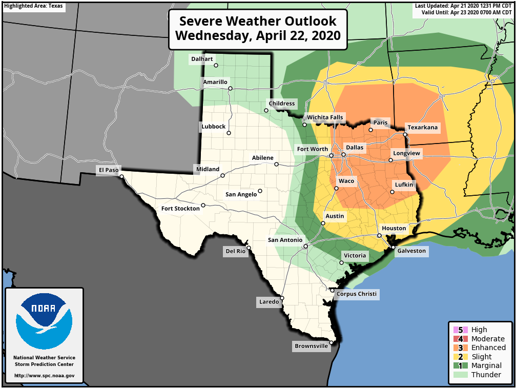 PLACEMENT: The position of the dryline tomorrow afternoon will determine the extent of the hail and tornado risk in North Texas. I believe the dryline will be somewhere near, or just to the west of I-35 (Denton to Waco).
TIMING: The main window for severe thunderstorms will come from around 4:00PM to 10:00 PM. The threat will initiate in Northwest Texas, shifting to the east through the evening and overnight hours. THREATS: Thunderstorms over North-central Texas will be capable of producing very large to giant sized hail, damaging winds, and a few tornadoes. Strong tornadoes (EF2 or greater) will be possible in the North Texas region, which includes the DFW Metroplex. CALL TO ACTION: It is late April. You know the drill. Be sure you have a way of receiving warnings. Have an action plan if you find yourself under a tornado warning polygon. •Have a NOAA Weather Radio in your home and workplace. Ensure that it is properly programmed with a fresh battery in it in case of power outages. •Make sure you have WEA (Wireless Emergency Alerts) enabled on your phone. Go to Settings > Notification > then scroll all the way down and make sure emergency alerts are on. Make sure you are in our free ApexStorm text messaging system as a secondary way of getting warnings. Text @apexstorm to 81010. •Identify the safe place in your home, which is a small room (hall, closet, bathroom), on the lowest floor, near the center of your house, away from windows. In that safe place, have helmets for everyone that lives with you, portable airhorns, and hard-sole shoes. •If you are in a tornado warning polygon, you musn't stay in a mobile home. Know where the closest site-built structure is located, and how to quickly get there. •Protecting yourself from a tornado is the first priority when it comes to the Coronavirus pandemic. Tornadoes and hail are immediate threats to life and property; get to your safe place first, then do the best you can to prevent the spread of the virus. Aforementioned above, there is the risk of a few tornadoes, but we will not see a system over 100 tornadoes in Dixie Alley on Easter Sunday. However, just know that all it takes it one tornado in the entire region, and if you come down your street, that is YOUR tornado event. ANXIETY: We are all tired of the Coronavirus. We are not here to scare anyone, or add to everyone's level of worry. However, we need to do our jobs of letting you know about the severity of the weather tomorrow. If you are feeling anxious reading this, just keep in mind that even in a severe weather outbreak, the chance of your house being hit by a tornado is low. Be sure to follow @donowx, @LoganShipleyWx, and @weltywx on Twitter, as we will be frequently posting forecast updates, warnings, and rapidly changing conditions on there. Donovan Neal Owner - ApexStorm After yesterday's severe storms, it was a much nicer and calmer day in North Texas. However, our severe weather risks ramp back up in the next 24-48 hours. More details below... FIRST OFF: A couple thunderstorms will develop late tonight near I/20, however the extent, if the lift is even enough for development, and intensity of these is uncertain. If storms develop, they will tap in to some elevated instability and strong deep layer shear. These storms could produce quarter to half dollar size hail and gusty winds. The overall severe risk is low. The SPC has outlined portions North Texas in a level 1 "Marginal Risk" for severe weather tonight.  These will clear out late tonight and we will be left with a partly to mostly cloudy day tomorrow. A few storms will be possible as a warm front lifts northward through the area dependent on a capping inversion. Strong low level instability and deep layer shear will favor a risk of supercellular structure in any storm that develops with UH near 250 m2/s2. The main risks will be large hail and damaging winds and will favor areas north/west of DFW. 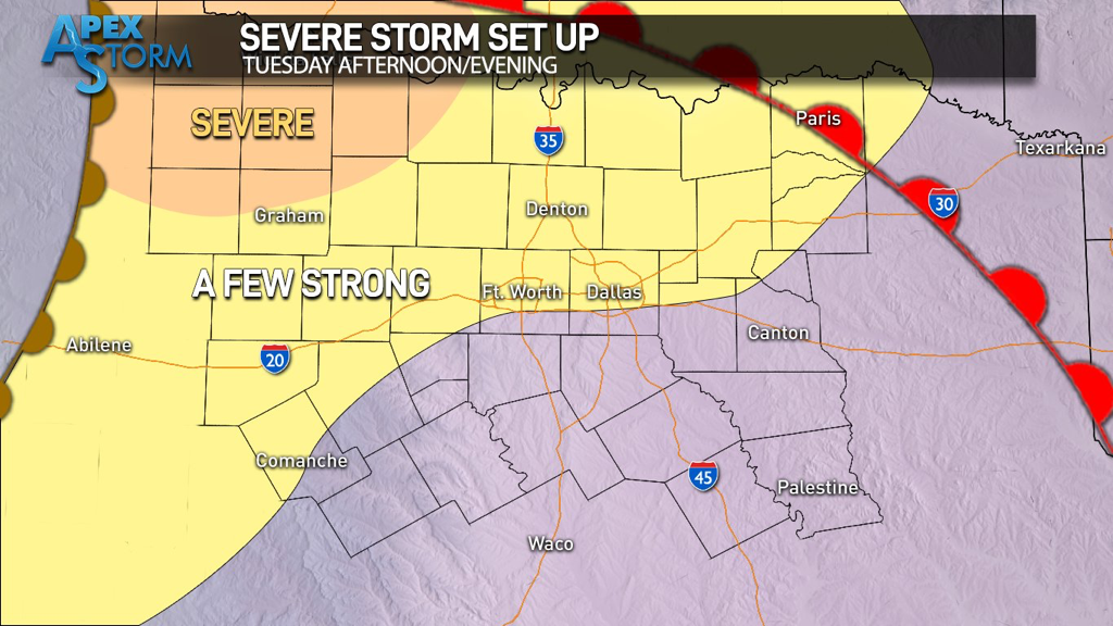 We will watch as they attempt to make a run at North Texas during the evening hours. Whether or not these make the trip (nonetheless even materialize) is very uncertain at this time. Below is a more aggressive solution from the TTU-WRF. 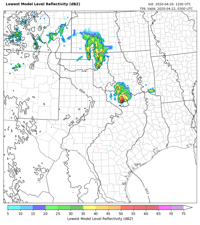 Meanwhile, the NAM 3km favors a dry forecast with any storms well northwest of our area. 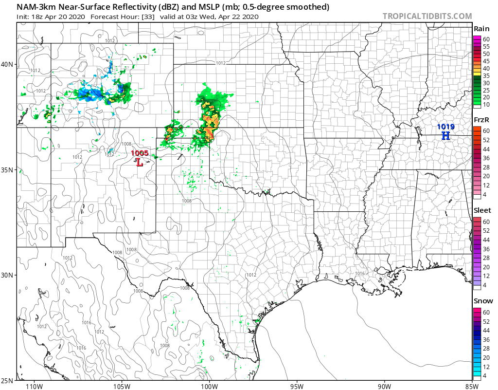 These storms will clear out of North Texas either way by early to mid morning on Wednesday, leaving us wide open in the warm sector with rapid destabilization expected. By late morning into early afternoon, we could see some development that will remain more elevated and will favor areas east of I/35 capable of large hail. However, by 3-5pm the dryline will be mixing west as our boundary layer mixes out and surface air parcels find the unstable and bouyant airmass set up east of the dryline. This will be the area to watch for initial supercellular development (near I/35) capable of initially very large hail and a tornado or two. The Storm Prediction Center has outlined a good portion of the area in the "Slight Risk" of severe weather with a hatched large hail risk. (--- meaning greater potential of 2" hail or larger---) Due to increasing LI's, storms will begin to cluster as they move into East Texas favoring a risk of heavy rain and damaging winds, and with increasing LLJ a QLCS-based tornado risk may evolve during the overnight hours in East TX into LA. 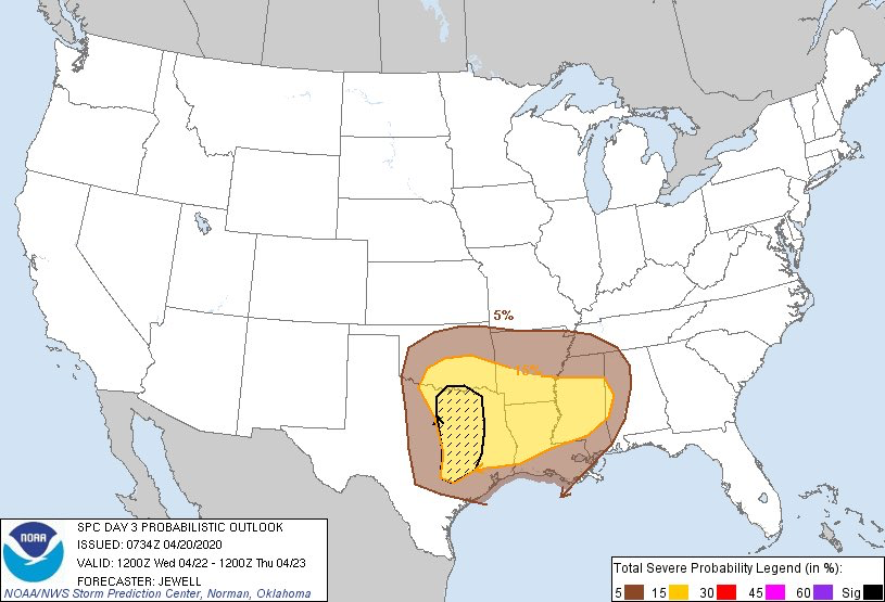 A cold front will follow the dryline and usher in drier air for Thursday, with temperatures in the 70s and pleasant temperatures. A quick return in moisture will occur Friday afternoon into the overnight, and a few storms may develop along a boundary that could pose a severe risk mainly east of DFW. A quiet weekend is expected, but storm chances will return early next week as the next shortwave approaches and a NW flow aloft begins to settle in.
Logan Shipley LOCALLY: Early morning/afternoon showers and thunderstorms continue to lift to the northeast, out of the region. New development is expected by the late afternoon hours, with the severe threat beginning in our counties to the west by 3p. We will continue to reach for the low 70s later this afternoon. TEXAS SEVERE WEATHER THREAT: As expected, the risk of severe weather for a good chunk of North Texas has increased as the mesoscale model data becomes more refined as well as reaching realizations of our current atmospheric conditions. A potent storm system with very strong wind fields is advancing to the east, and will continue to do so through the weekend, interacting with a very unstable airmass across Texas and the Deep South. As the atmosphere destabilizes, long-track, dangerous supercells evolve where the cap erodes and will subsequently move very quickly to the east to the north-east, capable of producing strong to violent tornadoes, very large hail, and damaging winds, depending on where you are in the Deep South. Our afternoon/evening of severe weather will be today through the overnight hours for much of Texas. The greatest risk of severe weather will lie in West and Central Texas. The SPC (Storm Prediction Center) has issued an "enhanced risk" level (level 3 of 5) of severe storms from a broad line from Childress to San Antonio, followed by the standard "slight" risk (level 2 of 5) encompassing the rest of the state. 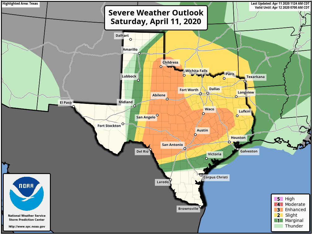 Continue to understand to understand it doesn't matter where you are in these colors. If you live in North or Central Texas, just understand that you have a chance of seeing severe weather this afternoon and evening into the overnight hours. Storms do not follow these guidelines that are used to illustrate where the best combination of thermodynamics and dynamics are. TIMING: Initial thunderstorm development will take place in Northwest Texas at around 3 to 4PM. These storms will move to the east-northeast with time, and the core threat of supercell thunderstorms will come during the evening to overnight hours, generally between 4PM and 12AM. Our last round of rain/severe thunderstorms will come from the Del Rio Valley, developing at around midnight, making its way into the North-Central Texas area from around 3 to 8 AM as the cold front moves to the east. THREATS: With the first round of supercell thunderstorms, all modes of severe weather will be possible, including primarily large hail, damaging winds, and a few tornadoes. Given the dynamics that are in place, while I don't anticipate widespread tornado reports, I do think there is *potential* for one or two intense tornadoes with the initial supercells that develop in Northwest Texas and move to the east. The threat with the pre-dawn QLCS (Quasi-linear convective system) will come from mainly damaging winds and (very) large hail in some spots. There is even the risk for a couple of embedded, brief tornadoes. RAIN: Rain amounts should generally stay below an inch for most places in North Texas, so flooding will not be of concern. Now, that we have covered this evening, let us shift the attention to our folks that may be affected in the Deep South. Please share this if you know anybody that might be in this area. The SPC maintains a "moderate risk" (level 4 out of 5) of severe weather for much of Central Louisiana, Mississippi, and parts of west and Central Alabama, with an "enhanced risk" (level 3 out of 5) encompassing much of the Deep South at this point. 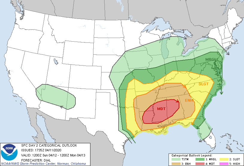 TIMING: Initial thunderstorm development will take place in the Ark-La-Tex region late morning as unstable air shifts northward in advance of the warm front. The peak threat of supercell thunderstorms for the most affected region will take place from around 12PM to 12AM.
THREATS: All modes of severe weather will be possible, including the threat for very large hail and damaging winds. Based on the magnitude of the atmosphere, several tornadoes are expected, including the potential for a few violent, long track tornadoes. UNCERTAINTY: WIth any severe weather event, comes with the air of uncertainty that could either make for a worse-case scenario or for storms to not be as intense, which is ultimately what we want. Elevated convection within the warm sector is expected during the morning hours, which could dampen the overall severe potential, or produce enough outflow to introduce a higher-end tornado potential. This type of uncertainty precludes the need to upgrade to a high risk with this forecast at this present time. However, confidence is still high that a macro-scale severe weather event takes place. WiLl tHiS bE LiKE aPRiL 27tH, 2011?: I really do not like this question at all. 216 tornadoes were confirmed that day, with a third of them being strong to violent. Those are generational events. Meaning, they tend to happen once every 40 years or more. However, bear in mind that if there is only one tornado in your state, and that happens to come down your street, that is YOUR April 27th, 2011. PREPARE, PREPARE, PREPARE: Today is day where you and your family need to keep ready for severe thunderstorms. Be sure you have multiple ways of receiving warnings. NEVER RELY ON A TORNADO SIREN. First, make sure you have a NOAA Weather Radio. Every home in the Plains and Deep South needs one as they work off of their own network, making them very reliable. On your phone, make sure you have WEA (Wireless Emergency Alerts) enabled on your phone. To make sure of this go to Settings > Notifications > scroll all the way down to the bottom to ensure that "Emergency Alerts" are enabled. If you live in the North-Central Texas region, be sure to join our text messaging system by texting @apexstorm to 81010; it is an excellent way of getting severe weather watches and warnings pushed to your phone, as well as daily forecasts and forecast updates. Find the safest place in your home. It is typically in a small room, on the lowest floor, near the center of your house, away from windows. In that safe place, have helmets for everyone, airhorns (in case you are injured and need to alert first responders on site), and hard-sole shoes (if you must walk over tornado debris). If you live in a mobile home, you can not stay put during a tornado warning. Identify the nearest location of a shelter or safe place, and know how to get there at a moments notice. YOU'RE GONNA BE FINE: I am well aware that we are in a time in our society that most people in the South, and nationwide, are suffering from high anxiety from a global pandemic. The last thing we want as trusted forecasters is to add to that anxiety. However, at the same time, we must present the weather situation the way it currently stands. If you are located anywhere in the Deep South, just know that there is no reason to panic about today or tomorrow. Even during a severe weather outbreak, the chances of a tornado hitting your house are low, as tornadoes are tiny compared to counties, or the entire state. Unfortunately, lots of amateur weather weenies are on the social media outlets today using a myriad of scare tactics, which is ridiculous and irresponsible. They do not have any prior knowledge behind the different models and maps, what they mean, or how to interpret it. Yet, people will share them without second guessing. Please stay away from these pages, as nobody needs more anxiety. Only get weather information from trusted sources (like this blog and our social media outlets). COVID-19: From the National Weather Service offices in Alabama and Mississippi, the Alabama and Mississippi Department of Health: MISSISSIPPI: This spring, the Mississippi Emergency Management Agency (MEMA), the Mississippi State Department of Health, (MSDH), and the National Weather Service (NWS) are offering the following guidance for how to take shelter from severe weather during the COVID-19 pandemic. The need to practice social distancing and prevent the spread of COVID-19 brings added complications to taking shelter from severe weather. However, state and federal officials agree that your top priority should be to protect yourself from a potential tornado. Officials recommend sheltering from tornadoes inside your home when possible. If you don't have a below-ground storm shelter, well-constructed homes and buildings provide life-saving protection from many of Mississippi's tornadoes. Take shelter in a closet, bathroom, interior hallway or other interior room with no windows on the lowest level of the house or building. For mobile home residents, you should abandon the mobile home in favor of a sturdy building during severe weather. This alternative structure should be a part of a severe weather plan that is identified well in advance. If your family typically takes refuge in a public storm shelter in your community, first check with your community shelter managers to ensure they will still be open and if there are any special considerations to plan for due to COVID-19. Now is the time to explore the best options to keep you safe from severe weather as well as limit your exposure to the virus. Don't wait until a tornado warning is issued to make a plan. Wherever you choose to shelter from a tornado: take as many precautions as possible to inhibit the spread of COVID-19 as best as you can, continue social distancing, and frequent handwashing. The best way to prepare for severe weather during a pandemic is to stay informed of the latest weather forecast from the NWS and local media: as well as the latest recommendations regarding COVID-19 from the Center for Disease Control (CDC), the Mississippi State Department of Health, and local authorities. ALABAMA: The decision to seek shelter in a community storm shelter is certainly made more difficult by the consideration for COVID-19, and each individual will need to make an educated decision on where and when to shelter from a tornado. At this time, the Alabama Department of Public Health (ADPH) is recommending that your first priority should be to protect yourself from a potential tornado. If a warning is issued for your area, you are more likely to be affected by the tornado than the virus. However, the decisions to open any community shelters are done at the local or county level. Before you make a decision to go to a community shelter, you should check with your community shelter managers to ensure they are open, and if there are any local COVID-19 considerations. Certainly, wherever you choose to shelter from a tornado, you should use as many precautions as possible to inhibit the spread of COVID-19 as best as you can. If you rely on public community shelters, now may be the time to explore other options that might keep you safer from severe weather and possibly limit your exposure to COVID-19. Keep tabs on our feeds @donowx, @LoganShipleyWx, the blog, and join the ApexStorm text message system by texting @apexstorm to 81010. Just hang tight, we will get through this together. MIDDAY: Morning clouds are continuing to clear the North-Central Texas region as we become more comfortable throughout the afternoon with temperatures approaching the low 70s with a easterly wind. Any chance of showers and storms will remain to the south of San Antonio. SEVERE WEATHER POSSIBLE FOR MOST OF TEXAS TOMORROW: Tomorrow's severe potential will mark the beginning of a multi-day outbreak of severe weather that will last until Monday for parts of the Southern US. A potent storm system with very strong wind fields will advance east through this weekend, interacting with a very unstable airmass across the Deep South. As the atmosphere destabilizes, long-track, severe storms will evolve where the cap erodes, and will move east/north-east, capable of producing violent tornadoes, very large hail, and damaging winds, depending on where you are in the Deep South. Our day of severe weather will be tomorrow afternoon through evening for much of Texas. The greatest threat of severe weather will lie in Central Texas, as I will show below. The SPC (Storm Prediction Center) has issued an "enhanced risk" (level 3 of 5) of severe storms for a fine from Del Rio to Lufkin, with the standard "slight risk" (level 2 of 5) encompassing the rest of the state. 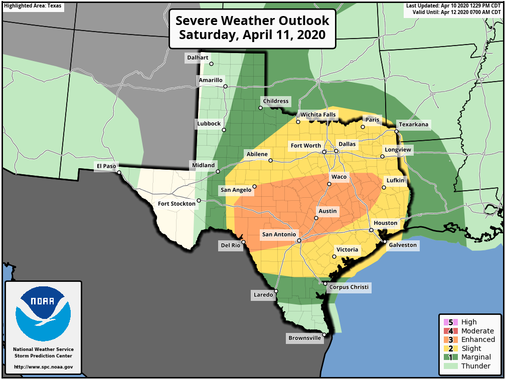 Like I say with any severe threat (this goes for those that are reading this anywhere in the Deep South), please be advised that these maps are only used for guidelines and that these storms do not follow these colors. These risks are used to simply illustrate where the best combination of thermodynamics and dynamics lie.
TIMING: I expect thunderstorm development at around the 1-2PM time frame in Central Texas, and will open the broad window for strong to severe storms in North-Central Texas from around 4PM to 11PM. THREATS: All modes of severe weather will be possible, including the potential for large hail, damaging winds, and tornadoes. Right now, we are looking at a potential MCS (mesoscale convective system) of strong to severe storms capable of producing large hail and gusty winds. However, keep in mind that any storm that becomes discrete will have the potential of producing a strong, long-tracked tornado. The warm sector is sufficiently north with low level shear of over 40kts in many places, combined with 90kts of 8kts shear will make for a very volatile environment for a tornado to thrive in. Also, this is mainly after the sun is set, which would make matters a little more worse because of the low level jet intensifying any shear and upper air forcing already existent. However, there is one caveat. If the storm mode is messy like what the meso models depict, there is a good chance that hail and damaging winds will be a primary threat. Keep in mind that this is entirely conditional and will depend on current observations tomorrow. I am not anticipating a tornado event, but an isolated strong tornado is possible, but not likely at this present time. RAIN: Rain should be confined to a little less than an inch, so flooding should not be a concern in North-Central Texas. CALL TO ACTION: I am very cognizant that we are in a time in our society that most people in the DFW Metroplex, and nationwide, are suffering from high anxiety due to the rapidly changing conditions in the midst of a global pandemic. The last thing we want to do as trusted forecasters is to add to that anxiety, but at the same time, we must present the weather situation the way it currently stands right now so you can be prepared. If you are located anywhere in the Deep South (not just Texas), just know that there is no reason to panic about the next couple of days, you just have to ensure that you and your family take the requisite steps to ensure that you are as safe as possible. First and foremost, you must have a way of receiving warning. NEVER RELY ON AN OUTDOOR SIREN. The baseline is each house being equipped with a NOAA Weather Radio that has fresh batteries, and is properly programmed (start here to get frequency and SAME code information for your area). On your phone, make sure WEA (Wireless Emergency Alerts) are enabled in your settings, under notifications. Furthermore, if you live in the DFW Metroplex, make sure to text @apexstorm to 81010 so you get notifications for when severe weather impacts the Metroplex. Know where your safe place is located, and be sure to have helmets and hard sole shoes, airhorns, or whistles for everyone in your house. If you are in a mobile home, know where you are going and how to quickly get there in the event of a tornado. No need to fear about the weekend. Keep a close eye on my twitter and the ApexStorm Facebook page. We will get through Saturday and Sunday together. Donovan Neal Owner - ApexStorm Scattered to widespread showers and even a couple t-storms are expected today, with temperatures remaining in the 40s. No severe weather is expected, but it is a good day to stay inside. (as we all should be anyway) Temperatures stay steady tonight. Warm air advection increases tomorrow, and we will rebound into the low to middle 60s. The STJ will allow for impulses of energy to provide scattered showers and a few thunderstorms through the day tomorrow, but nothing severe is expected.
A southwesterly flow regime will continue into Monday, and deep moisture will continue to remain in place. More impulses of energy will come along with the remaining STJ, leading to more scattered thunderstorms mainly during the heating of the day. Monday will be warmer and humid with highs in the middle 70s. A slightly greater amount of instability will be in place, so a strong to marginally severe storm or two with 40-50mph winds and upwards of 1" hail in diameter will be possible. Strong southwesterly winds will increase high temperatures on Tuesday, with a dryline pushing eastward towards I/35 during the afternoon. Temperatures will soar well into the 80s Tuesday afternoon with partly sunny skies. There will be a low chance of a storm along the dryline, however veered flow on the humid side and dry side of the boundary will limit any type of convergence that attempts to establish. Therefore, the chance of any storms on Tuesday is very low, but not zero. If a storm does manage to develop or a more defined set up occurs, we will have a very unstable and decently sheared environment capable of severe storms. Again, the chance of any development is low but will remain watched. Wednesday is the more interesting day of the week with a leading trough and surface low combining with a cold front sagging into the Southern Plains with an established dryline in our western counties. A veered flow will be in place ahead of this dryline, and convergence may be better than Tuesday leading to the chance of scattered thunderstorms in the afternoon/evening hours. An unstable and sheared environment will be in place, so there will be a threat of severe weather if storms can develop. There is significant difference among global guidance on whether storm development occurs or not. This will be watched the next few days. Either way, a cold front will move into North Texas late Wednesday night and thunderstorms will likely develop along the boundary. There will be a risk for strong or severe storms during this timeframe, but the extend of storm coverage and the severity of storms is still rather unknown. Thursday will be much colder and windy with temperatures likely falling into the 50s during the afternoon. Scattered showers will remain possible through the day, but nothing widespread or severe is expected. A warming trend will take place next weekend, but dry weather is expected at this time. Logan Shipley |
Archives
April 2024
Categories |
 RSS Feed