
|
THIS AFTERNOON: It warmed very nicely to the mid 70s around lunch time! We will continue to see the temperature warm to the low 80s during the late afternoon and evening hours. THREAT OF SUPERCELLS TOMORROW: Let's just preface this blog by saying that this is the most serious threat of severe weather we have had in recent years. We saw what has been going on the past couple of Sunday's in Dixie Alley and Mississippi, and knew that our time was inevitably coming. So, here we are. Another vigorous spring weather system will impact the Ark-La-Tex and Piney Woods region tomorrow afternoon and evening, with the threat of tornadoes, very large hail, and damaging winds. SETUP: The mid-level jet will become coupled with the low-level jet by the afternoon and evening hours, especially after sunset, creating a favorable combination of lift, shear, and helicity for potentially strong tornadoes and very large to perhaps giant sized hail. The greatest probabilities for a localized episode of tornadoes is forecast from south-central Oklahoma through much of the North-Central Texas in the greatest threat of the "enhanced risk" area. In addition to the tornado risk, very large to giant sized (golf ball sized or larger) hail and wind damage will like be likely across a large part of the Ark-La-Tex region tomorrow afternoon and evening. The threat for damaging winds is expected to increase as a mesoscale convective system (MCS) moves eastward across East Texas overnight, eventually into Louisiana and Arkansas by Thursday morning. An hour ago, the SPC (Storm Prediction Center) has defined a "enhanced risk" (level 3/5) for areas along and east of I-35 and along and south of I-40 in Oklahoma and Arkansas. There is the standard "slight risk" (level 2/5) from generally to the east of Wichita Falls into the Houston area, and a "marginal risk" (level 1/5) defined as far out as Wichita Falls, Ranger, New Braunfels, and Victoria. 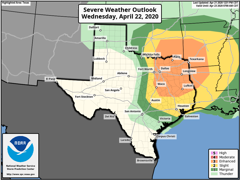 PLACEMENT: The position of the dryline tomorrow afternoon will determine the extent of the hail and tornado risk in North Texas. I believe the dryline will be somewhere near, or just to the west of I-35 (Denton to Waco).
TIMING: The main window for severe thunderstorms will come from around 4:00PM to 10:00 PM. The threat will initiate in Northwest Texas, shifting to the east through the evening and overnight hours. THREATS: Thunderstorms over North-central Texas will be capable of producing very large to giant sized hail, damaging winds, and a few tornadoes. Strong tornadoes (EF2 or greater) will be possible in the North Texas region, which includes the DFW Metroplex. CALL TO ACTION: It is late April. You know the drill. Be sure you have a way of receiving warnings. Have an action plan if you find yourself under a tornado warning polygon. •Have a NOAA Weather Radio in your home and workplace. Ensure that it is properly programmed with a fresh battery in it in case of power outages. •Make sure you have WEA (Wireless Emergency Alerts) enabled on your phone. Go to Settings > Notification > then scroll all the way down and make sure emergency alerts are on. Make sure you are in our free ApexStorm text messaging system as a secondary way of getting warnings. Text @apexstorm to 81010. •Identify the safe place in your home, which is a small room (hall, closet, bathroom), on the lowest floor, near the center of your house, away from windows. In that safe place, have helmets for everyone that lives with you, portable airhorns, and hard-sole shoes. •If you are in a tornado warning polygon, you musn't stay in a mobile home. Know where the closest site-built structure is located, and how to quickly get there. •Protecting yourself from a tornado is the first priority when it comes to the Coronavirus pandemic. Tornadoes and hail are immediate threats to life and property; get to your safe place first, then do the best you can to prevent the spread of the virus. Aforementioned above, there is the risk of a few tornadoes, but we will not see a system over 100 tornadoes in Dixie Alley on Easter Sunday. However, just know that all it takes it one tornado in the entire region, and if you come down your street, that is YOUR tornado event. ANXIETY: We are all tired of the Coronavirus. We are not here to scare anyone, or add to everyone's level of worry. However, we need to do our jobs of letting you know about the severity of the weather tomorrow. If you are feeling anxious reading this, just keep in mind that even in a severe weather outbreak, the chance of your house being hit by a tornado is low. Be sure to follow @donowx, @LoganShipleyWx, and @weltywx on Twitter, as we will be frequently posting forecast updates, warnings, and rapidly changing conditions on there. Donovan Neal Owner - ApexStorm |
Archives
March 2023
Categories |
 RSS Feed
