
|
Looking at the radar, there isn't really that much action going on across the region, however, it is important to note that there will be a redevelopment of marginally severe thunderstorms later this evening towards rush hour. These storms will not be too intense, and will only produce lightning, heavy rain, some gusty winds, and small hail at times. They will quickly move out of the region when the sun goes down. SEVERE WEATHER OUTBREAK POSSIBLE TOMORROW AFTERNOON AND EVENING - A potent storm system coming from the west combined with soupy, moist air from the Gulf will set the stage for potentially significant severe weather tomorrow from North and Central Texas through the Mississippi River Valley. The SPC (Storm Prediction Center) has issued a "moderate" risk (level 4 of 5) of severe weather for communities to the east of downtown Dallas, with the rest of the metroplex and the North-Central Texas region under an "enhanced" risk (level 3 of 5) of severe storms for tomorrow. 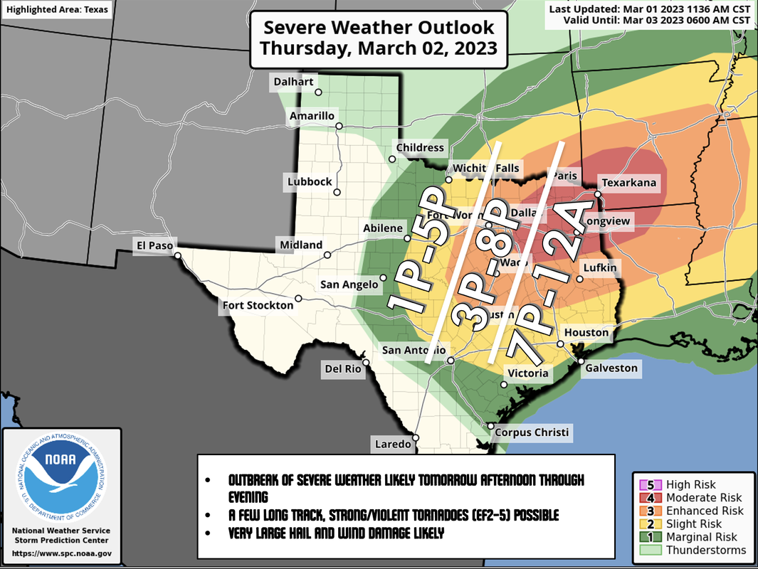 While looking at this map, I always implore people to not get hung up on the exact placement of these colors and lines. Storms inevitably do not follow these maps. They are used to give a general idea of where most of the severe weather is anticipated to happen.
TIMING - In the early morning hours, there will probably be some strong to marginally severe thunderstorms to the south and east of the DFW metroplex. Most of it should be gone by late morning. Everyone in the North-Central Texas region has the potential of seeing severe weather from a broad window of 12pm to 12am tomorrow. However, the core threat for the metroplex will come tomorrow afternoon around the time when most school districts end for the day. The main event for east of the metroplex will come later in the evening after the sun goes down. THREATS - All modes of severe weather will be possible. Very large hail (2" in diameter or greater), wind damage, and several tornadoes are all possible. There might even be a few strong/violent (EF2-EF5) long-track tornadoes tomorrow evening. RAIN - Amounts of 1-2" of rain are likely, and some isolated flash flooding issues are possible. GET READY NOW - Here are some important notes about preparing for tomorrow.
DO NOT BE ANXIOUS OR WORRIED! Events like this are very common in North Texas during our regular tornado season, which includes March, April, and May. Have a way of hearing warnings, have an emergency plan, and you will be fine. Although the odds of any one spot getting a tornado are very low, we must be prepared nonetheless. BE INFORMED: I know I have many first-time readers here. So I would like to say welcome and thank you for taking the time to read my products! I will have many more as we get closer to this event. If you would like frequent weather updates from me, please follow my Twitter @donowx. Please also like our Facebook page linked here. Also, please join our text messaging system to receive daily forecasts and updates by texting @apexstorm to '81010'. Or click the link. |
Archives
April 2024
Categories |
 RSS Feed