
|
TODAY - A warm front is exiting most of Texas this morning. For North Texas, that means skies will remain generally cloudy with isolated to perhaps scattered showers throughout the day, mainly during the afternoon. It will not be a complete washout, but, just keep a close eye on the radar for rain at times. A few rumbles of thunder is possible, but no severe weather issues today. The Storm Prediction Center has removed the marginal risk for parts of North Texas today. Highs will be in the upper 60s to lower 70s. TOMORROW - The old front will exit Texas, and a new, stronger front will begin moving through the region during the morning. Showers will be ongoing for parts of Northeast Texas, eventually spreading to the southeast throughout the day. Most communities will stay dry in the morning, but isolated to scattered showers will increase through the afternoon. Just like Saturday; not a widespread event, but just rain at times. Some storms may produce some thunder, and some of the stronger storms may pose a threat for hail and gusty winds. Highs in the mid to upper 60s. MONDAY - Widespread showers and storms are possible especially during the pre-dawn hours and through most of the afternoon. The cold front will have exited the region by now. Rain will eventually taper off in the evening. No severe weather is expected and afternoon highs will be in the mid 50s due to rain cooled air. TUESDAY - The activity will have finally moved out of the region by early Tuesday morning, which should lead to most of the day being dry, although mostly to partly cloudy. A stray shower or two is never out of the question. Highs will be in the upper 50s/low 60s across the area. WEDNESDAY - The chance of us seeing some sunshine during the day is much greater on Wednesday as we start to dry out now that the shower and thunderstorm activity is out of North Texas. Skies will be mostly sunny with highs in the upper 60s. THURSDAY - A surface low looks to form over the Texas Panhandle during the day that will be moving in our direction throughout the evening. While most of the day will feature a mix of sun and clouds with highs in the upper 60s to low 70s, I can not forget the potential for isolated showers Thursday night and Friday morning as the low rotates through our area. FRIDAY - The low quickly rotates out of our area, and we should be completely dry by daybreak. Another pleasant, spring-like day is expected with highs in the mid to upper 60s across the region. 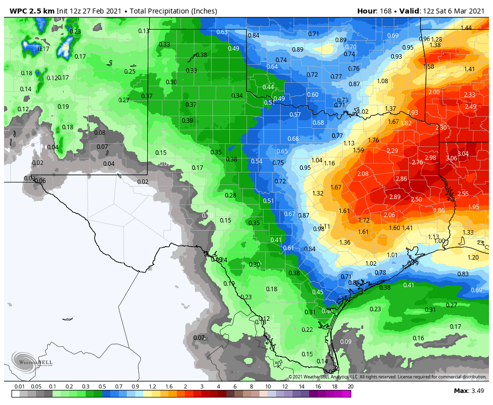 PROJECTED RAINFALL AMOUNTS - We can expect a decent amount of rainfall over the week ahead as the WPC is projecting anywhere from .5-2" of rain for much of North Texas.
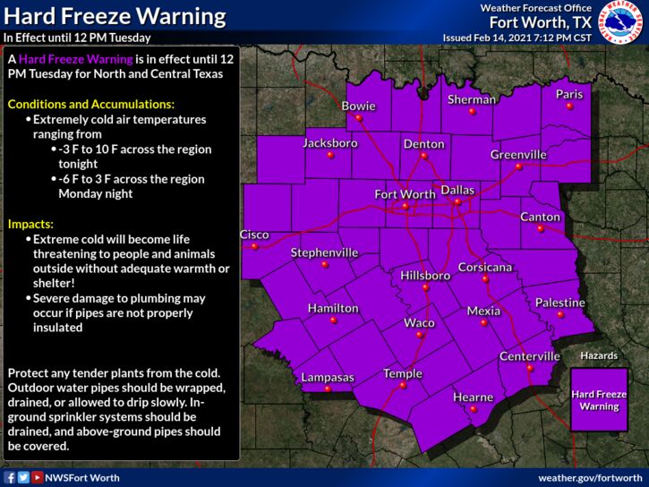
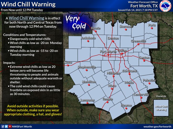
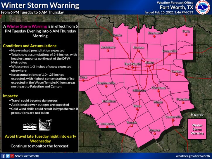
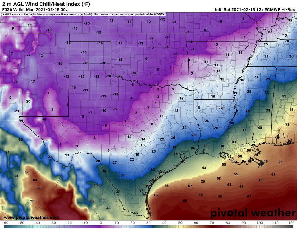
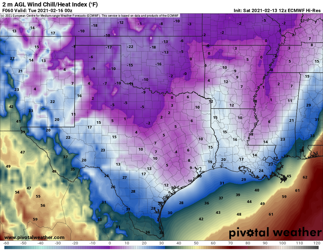
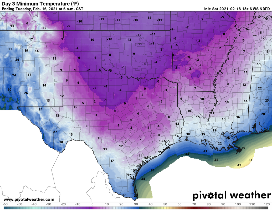
Donovan Neal Owner - ApexStorm Another surge of arctic air is expected over most of the region overnight, which will create the coldest airmass North Texas has seen since 1989, despite us seeing that type of cold this morning. The NBM (National Blend of Models) currently has all of the region at zero degrees, with several places reaching below zero Tuesday morning... 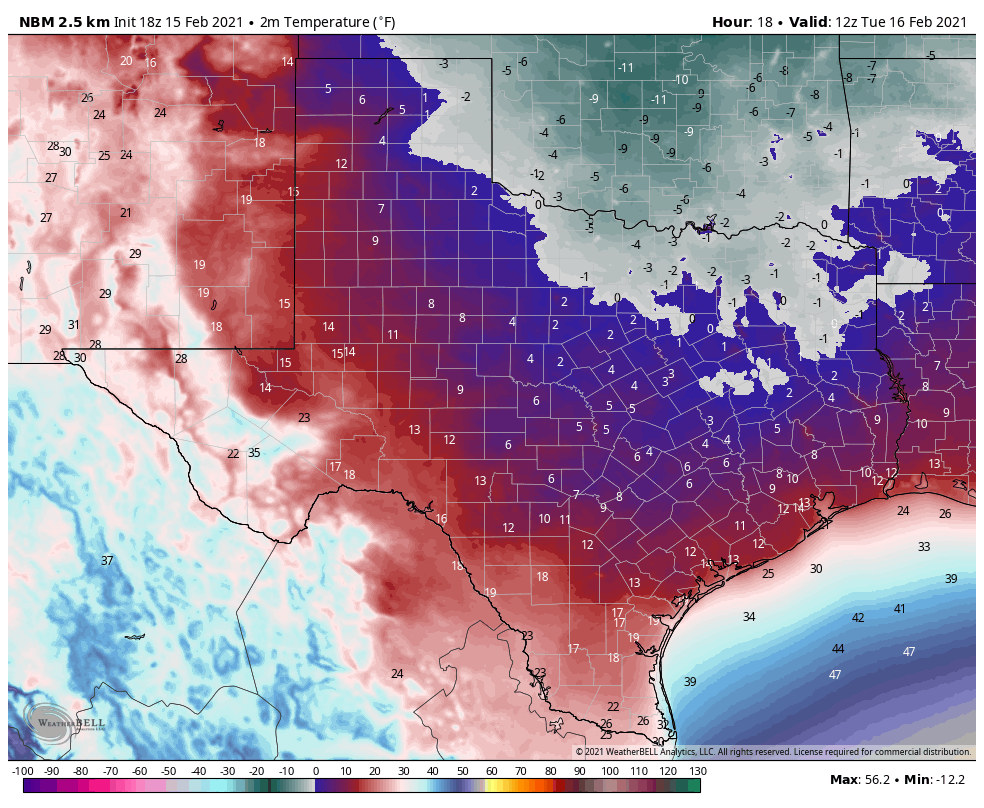 This will allow all of the snow and ice we saw yesterday to continue to stay in place for another day, making travel extremely difficult to nearly impossible throughout the day. I expect the demand to be the same for power across the state, so I don't see any improvements to the power situation across Texas anytime soon. As of 8:08 PM, 4,363,283 Texans are without power right now... 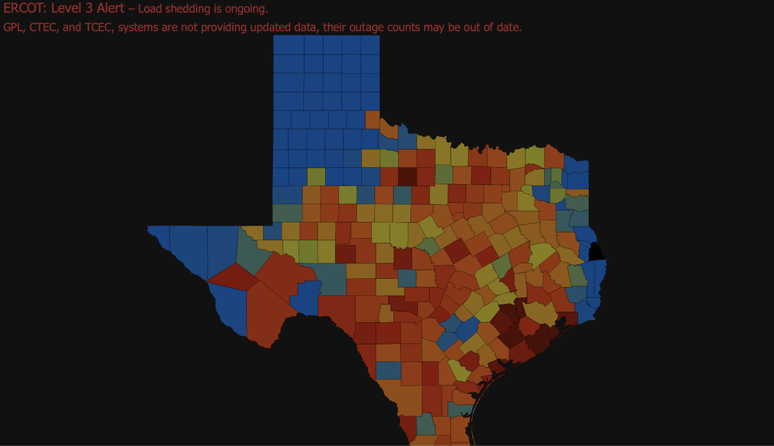 I wish I had good news to share with you all, other than the fact that the sunshine did help just a tad, but not enough to make a difference because of the frigid temperatures. I don't see any improvements on the roads unless they are plowed or until Thursday at the earliest very earliest. WINTER STORM #3 - Our last potent winter storm of this series will impact portions of North Texas, but mainly into East Texas tomorrow night into Wednesday with potential for enough snow and ice accumulation to continue major travel impacts and power outages into Thursday. WATCHES/WARNINGS - All of our North Texas counties are under three warnings... A Hard Freeze Warning is in effect for all counties in North Texas until 12:00 PM tomorrow. A Wind Chill Warning is in effect for all counties in North Texas until 12:00 PM tomorrow. A Winter Storm Warning is in effect for all counties in North Texas until 6AM Thursday morning.
PLACEMENT: The main impact will come in the Winter Storm Warning area. An additional 1-3 inches of snow is possible across the region, which the northwestern side of the region potentially seeing 2-4". For the southern 2/3's of our area, such Waco, Temple, Coriscana, etc., I expect most of your impacts to come in the form of freezing rain, some of which can be heavy at times. That will cause re-icing on most bridges, overpasses and roads. For now, expect another round of snow for all of North Texas, including the Dallas/Fort Worth Metroplex Tuesday evening through Wednesday. However, freezing rain and sleet will also be an issue along with the heavy to moderate snow at times. A change to freezing rain is a good possibility across DFW and points to the south and east as the system skirts eastward with time. Places like Corsicana, Tyler, and Palestine could see a half an inch or more of freezing rain with this event. Some freezing rain is possible as far north as the I35 Junction in Denton county. But again, for most of those in the Winter Storm Warning, it will mostly be snow, some sleet, and freezing rain, in that order. TIMING - The precipitation will come in two phases. The first round will come in a very small window late Tuesday night; light to moderate snow is possible for the northern 2/3rds of the region during that time. Amounts from that will be fairly light, but, it doesn't take much for places to re-ice again, especially since we are still below freezing. The main event will come at around or after midnight for much of North Texas where snow, sleet, and freezing rain will become heavier and more widespread across the winter storm warning area. Impossible travel conditions will continue across the region, and a final layer of ice on top of the snow that has already fallen, including on top of trees and power lines. Precipitation will be over by Thursday afternoon for most of the North Texas region. Roads across the region could remain icy and dangerous all the way through Friday, since temperatures will not reach above freezing until then, even with sunshine. IMPACTS - Not only will be looking at the potential for more heavy snow, but freezing rain and some sleet will be possible. Ice accumulation of .10" to .25" is likely, with additional .40" spots as well. Travel will remain difficult, if not impossible in many areas due to a fresh coating of ice on roads and surfaces. Rolling power outages are likely statewide. This will be a more impactful ice storm for areas to the south and east of the metroplex. 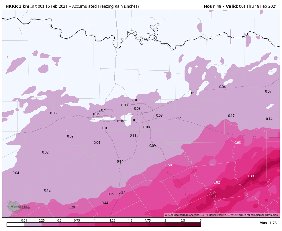 REMEMBER: When we release a snowfall map tomorrow, the boundaries won't be in straight lines like the maps we show you; they are simply used as a guideline. But understand that some places in the winter storm warning will see little to no freezing rain and all snow, while others will see just freezing rain.
More forecast adjustments are possible tomorrow. If you are reading old information, you are working with bad information. PREPARE - Use tomorrow to prepare as much as you can around the house... *Be sure all of your phones, tablets, and other devices are fully charged. *Travel is highly discouraged. If you MUST travel, create an emergency supply kit for your car. Include jumper cables, sand, a flashlight, warm clothes, blankets, bottled water and non-perishable snacks. Keep a full tank of gas. Have cat litter or sand to help tires get traction, or road salt to melt ice. *Gather supplies in case you need to stay home for several days without power. Keep in mind each person’s specific needs, including medication. Remember the needs of your pets. Have extra batteries for radios and flashlights. *Turn your refrigerator and freezer to their coldest settings. *If you lose power and you plug a generator into the house electrical system, turn the main off in the breaker box. Otherwise it can be very dangerous for the crews working to restore power. *Understand some could be without power for more than 24 hours with very cold, sub-freezing temperatures. Have an alternative source of heat. And, use it safely. CONNECT - You can find me on all major social media networks... ApexStorm Text Messaging Join Link Donovan Neal Owner - ApexStorm Before I talk about this region specifically, I would like to point out that Winter Storm Watches or Warnings are in effect for ALL counties of Texas. The entire state of Oklahoma is under a Winter Storm Warning... 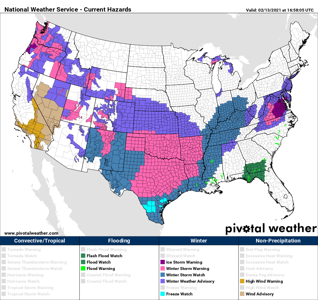 Persons within a winter storm watch will likely be upgraded to a Winter Weather Advisory or a Winter Storm Warning later this afternoon or evening. However, I encourage you not to get hung up on the exact verbiage of these advisories. The main point is, we are expecting accumulating winter precipitation and brutally cold weather across ALL of Texas over the next several days. WEATHER FORECAST HEADLINES - This is probably the most strongly worded headlines I will probably ever write during my time forecasting the weather. The truth is, we have not seen such potential for a winter weather event of this magnitude since the Arctic Outbreak of 1989. With the combination of a winter storm that has the potential to bring snowfall, blizzard-like conditions, freezing rain, and sleet for pretty much everywhere in the Lone Star State, followed by the coldest airmass we have seen in more than three decades, this leads me to conclude that this is a generational event; an event that tends to happen once every 30 years. 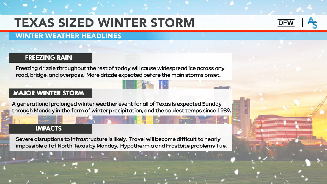 FIRST CALL SNOW ACCUMULATIONS - We continue to forecast significant amounts of snow for the northern two thirds of Texas late tonight through Monday morning. Just like I said I would, we went ahead and delayed making a snowfall map until this morning at the earliest since the storm is in the West Coast now. Here is our first official snowfall accumulation map, made today at 11:00 AM... 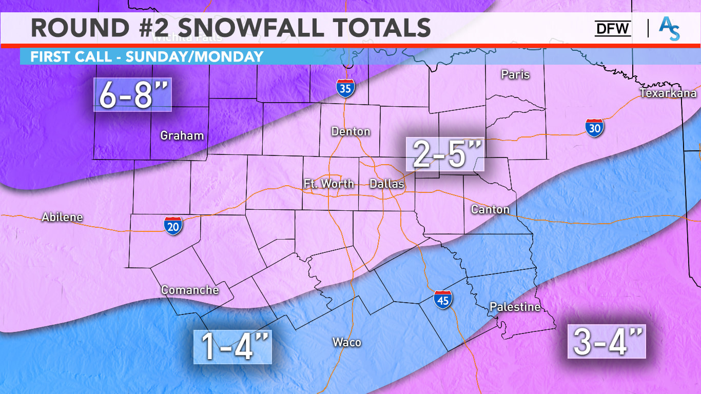 Regarding amounts, it’s still a bit shaky. Keep in mind that this is still on the conservative side of the spectrum, and that any location on this map can see a lot more than forecast. Our NW counties could see 6+ inches of snow, with 2-5” likely in the Metroplex. Yes, it is possible some you see only an inch, some of you may even see 6 inches. It is a wide range due to banding and it is nearly impossible for us to predict, but 100% of North Texas will see snow tomorrow. A good range for us is 2-5 inches with isolated higher and lower totals possible. With temperatures likely in the teens tomorrow afternoon, all this snow will accumulate very easily and travel will be near impossible. Due to gusty north winds and powdery snow, blowing snow will be threat tomorrow and on Monday, even when it’s not snowing. The winter storm warning continues until 6pm on Monday. It is important to note that this storm will not follow these specific guidelines at all. Some places may see more or less snow than what is presented in this forecast, but I think this is a good map; a map that will give everyone in the region an idea of how much snow they can REASONABLY expect. Understand that this map can and will change, even within the next 12 hours. We will probably have another one of these made before you go to bed today. WHAT MAKES THIS WITNER STORM SO DIFFERENT FROM OTHERS WE HAVE SEEN? - Temperatures are currently way below freezing, and will continue to stay that way for a very long time, probably through Thursday. As a result, this winter storm will not be a southern-style winter storm where it snows, and we see roads turn perfectly normal within a few hours of the snow ending. Like I said in yesterday's discussion, this will be a Midwestern style winter storm, where surface temperatures are already below freezing. As a result, anything that falls from the sky, whether it is snow, sleet, freezing rain, etc., will have no problems freezing over, sticking, and turning into ice skating rinks. Additionally, because the air is much drier than with typical snow events in Texas, snow will weigh much lighter. Combined with north sustained winds of 10-20 mph with higher gusts at times, you now mention the issue of blowing snow and near-blizzard conditions, especially for the northern two-thirds of the state. This is exactly why we have been stressing over the fact that travel will become impossible Sunday through at least Tuesday. TIMING: Timing has changed significantly over the past few days. We will be dealing with two storm systems in the next few days. It is now looking like the main event for North Texas from storm #2 will come throughout Sunday, lasting all the way through Monday morning. 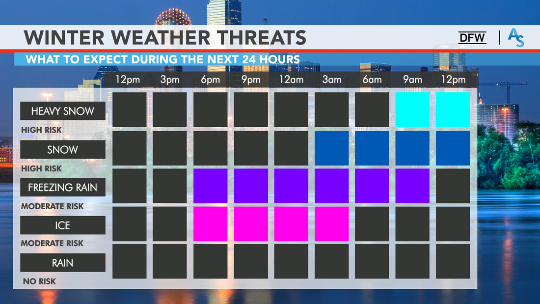 Our first storm system that will affect us is weaker but will be strong enough to sneeze a little winter precipitation before the main storm's onset. Freezing drizzle and rain, and light snow may occur this evening and overnight across North Texas before the main event Sunday morning. While this isn't the main event yet, it is best to not travel when this occurs. Freezing rain creates a glazing of ice on the roads, and it does not take a winter storm to cause major issues on the road ways. The main system will move east overnight, and we could see snow for our far west and northwestern counties as early as the predawn hours tomorrow. Moderate snow should be moving into North Texas, including the DFW metroplex by tomorrow afternoon. Then, a full-fledged mess will unfold for the region by late afternoon tomorrow through tomorrow evening. Most of the snow should be out of the region by Monday afternoon Untreated roads will probably stay undriveable through Wednesday evening at the very, very earliest. HISTORICALLY COLD TEMPERATURES AFTER STORM #2 - As if we weren't cold enough, another brutally cold arctic airmass moves southward on the backside of the departing storm system. This, combined with the cold we are already experiencing, will set the stage for the coldest conditions we have seen in decades by Tuesday morning.
The only way the roads will improve before Wednesday or even Thursday when they get plowed or sanded. Even then, most back roads or untreated roads in residential communities will remain hazardous.
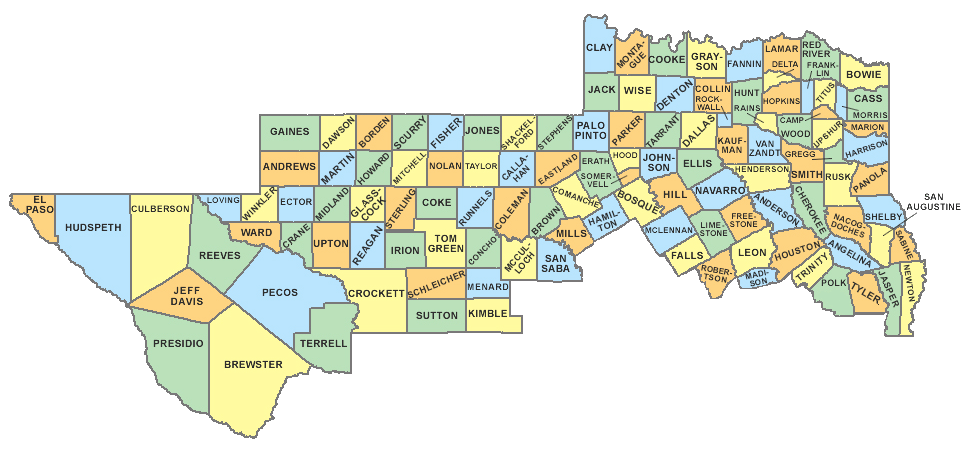
BUT WAIT, THERES MORE! - Another potent upper level storm system will move across the state Tuesday night and Wednesday. Since we have the arctic airmass in place already, this could result in another significant winter storm for North Texas. In addition to what we see with storm #2, several inches of snow is possible for our region again. In fact, this system might be the wetter one with moisture, causing wetter snow and more precipitation than storm #2! This is why I am so adamant that conditions won't start improving until Thursday at the earliest. We will revisit this once we get past tomorrow and Monday. AFTER IT ALL ENDS: - We will be dry for a minute and start slowly increasing in temperature after Wednesday. Even then, we will not see temperatures above freezing until at least Thursday, if the snowpacks melt during that time. CONNECT - You can find me on all social networks... ApexStorm Text Messaging Join Link Donovan Neal Owner - ApexStorm Three Potential Winter Storms With Dangerous Cold This Weekend and Early Next Week For North Texas2/12/2021 One really rough day of winter weather is down in the books. However, we are only a fraction into this entire event, as we have three more potential winter storms to get through over the next five days. Like I said yesterday, not only will this include winter precipitation, but also the coldest air North Texas has felt in decades with some of that cold air already in place as the snow is falling. Definitely not a good combination and certainly not a combination that we are accustomed to. DISCLAIMER: As I mentioned in yesterday's blog entry, this forecast WILL change. I strongly encourage you to only keep up to date with latest information. Remember, if you are reading products that are 16-24 hours old, you are using bad information. READ ME READ ME READ ME READ ME PLSSS: TODAY WILL BE THE LAST GOOD DAY TO PREPARE BEFORE SEVERAL DAYS OF WINTRY PRECIPITATION, DANGEROUSLY COLD TEMPERATURES THAT CAN LEAD TO HYPOTHERMIA AND FROSTBITE IF PRECAUTIONS ARE NOT TAKEN, AND LIFE-THREATENING, HAZARDOUS TO NEAR IMPOSSIBLE TRAVEL CONDITIONS. CONDITIONS WILL SLOWLY START TO GO DOWNHILL SATURDAY NIGHT. FRIDAY: Not as chaotic as yesterday for obvious reasons. We will still need to be on the lookout for freezing drizzle tonight where temperatures are below freezing. That being said, a majority of this blog entry will be focused on tomorrow and early next week. I will post updates about today's conditions on my twitter page if needed. WINTER STORM #1 ON SATURDAY - If you read yesterday's blog, I briefly touched on this. However, I neglected to go into full detail due to some uncertainties. I am getting more concerned about a quick-hitting storm system for much of North and Central Texas for Saturday afternoon and evening. While precipitation mode remains uncertain, this could be a freezing rain/sleet/light snow event for the aforementioned regions. At this time, light snow at times would be the most probable if you are along and north of the I-35W/E Junction in Hillsboro. Conversely, freezing rain and sleet will be more of an issue if you are located so the south of that Junction. In more simple terms in regards to travel, it is possible that roads will start deteriorating in our southern counties by tomorrow evening. Please also be advised that this first storm will not result in a complete whiteout; chances are, you will not see much of any snow fall out of the sky while some areas receive anywhere from a dusting to an inch at best. However, do take notes from yesterday. It does not take a full fledged winter storm to cause major issues on the roads. WINTER STORM #2: THE BIG ONE - I understand that most of you have stayed in the south for most of your life and are not accustomed to Midwest-type winter storms. So, let me preface this section by reminding everybody that when we have winter storms in North Texas, temperatures are generally above freezing in most spots where snow does fall, precluding any extended travel issues after the snow has ended. However, this will not be the case this weekend into early next week. Temperatures will be well below freezing (32°F>) when the snow is falling. This will not only cause dry, powdery snow to fall since the warm air just above the surface is missing, but will also cause long-term travel issues as a result of surfaces already being below freezing, allowing for any precipitation that falls to freeze and accumulate. The drier snow will be more prone to movement by gusty winds, which we will have with this storm. Gusty winds of 10-20 mph with occasionally higher readings is likely. As a result, near blizzard-like conditions are possible, along with the possibility of snowdrifts. HOW MUCH SNOW WILL FALL? - Because the storm system responsible for causing this event is not in our upper air network yet, I will refrain from giving away exact forecast amounts. Instead, I will say that everyone in North Texas has a chance of receiving anywhere from 2-7 inches of snow. Isolated higher amounts are possible, of course. Once this storm system arrives in the West Coast tonight, expect a snowfall map from us as early as potentially tomorrow morning, when we will have access to weather balloon data, as well as higher resolution guidance. WHEN WILL IT GET HERE? - The simple answer is that no one truly knows an accurate answer to that yet. Light snow will already be taking place across the Panhandle by Saturday afternoon and evening, quickly spreading into West Texas during the overnight hours. Precipitation will quickly increase in size and intensity as it slowly begins its journey to the east over the rest of the Lone Star State. Forecast guidance has tried to speed the system up in the last couple of runs, resulting in a mostly Valentines Day event with precipitation ending across East Texas by daybreak on Monday. Others have continued to display a Sunday evening - Monday afternoon event. Like I mentioned previously, we will get a better handle on the timing of this system tomorrow morning. HOW COLD WILL IT GET? - Another surge of arctic air will reach the North Texas area Monday night through Tuesday morning. As if it can't get any colder, this will create the coldest airmass North Texas has seen in decades. Morning lows on Sunday will be in the teens, followed by single digits on Monday, finishing off at near or below zero on Tuesday morning. These are morning lows that I am talking about. Not wind chills. In the worse case scenario, we will see wind chills around 20 below zero for several areas in North Texas. IMPACTS - This will be an extremely dangerous situation for those who are caught traveling in this. With near-blizzard conditions anticipated at the climax of this event, travel will become nearly impossible. I cannot stress how dangerous it will be to travel on Sunday, Monday, and even Tuesday for all of North Texas. It may last several days for the communities that receive significant snowfall/ice accumulations. Power outages are likely in the places we see significant snow and ice buildup on trees and powerlines. Some power outages are possible due to the extreme cold, which will increase the demand for energy. All pipes will be susceptible to bursting if not insulated properly. Hypothermia and frostbite will be possible for those not dressed appropriately. Additionally, we will need warming shelters if the winter storm results in widespread power outages and stranded travelers. Ice and snow will exist on the roads for several days or until road crews are able to plow through the snow drifts. STORM #3 - I alluded to this in the last discussion, but long range forecast guidance suggests the potential for yet another winter storm for much of North Texas either Wednesday or/and Thursday. This would only delay recovery efforts from storm #2. To mitigate the risk of information overload, I will get into more specifics once we through the event this weekend. :-) MAP LITERACY - Just about anytime we forecast extreme weather, we get dozens of messages that consist of "what about *insert town or city here*". Most of these messages come on posts with references to counties or major highways in North Texas. In my five years of doing this, I have learned that several people struggle with geography, and more specifically have a tough time trying to read maps. I understand. I struggle with many things to. If you were to give me analytic geometry questions, I would look at you like you just shot a man before my eyes. But there is no way we can name hundreds of municipalities in North Texas on every post. I encourage you to take a few minutes to learn the major highways and counties relative to your location. I promise it will help you understand the blog entries and the posts I make here addressing any time of weather extreme.
CONNECT - You can find me on all of the major social networks...
ApexStorm Text Messaging Join Link Donovan Neal Owner - ApexStorm FREEZING LINE: The freezing line is south to a line from Marathon to Rocksprings to Boerne to Giddings to Jacksonville to Clarksville. The line represents where temperatures are 32° or below, or, for simple terms, where it is below freezing. As you can see, a majority of the Lone Star State fits under that category right now... 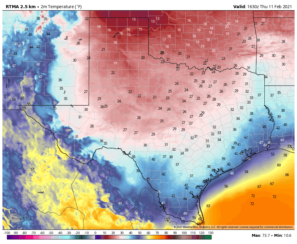 As we saw this morning, the rain, combined with below freezing temperatures, resulted in freezing rain causing ice accretion on several major highways, roads, bridges, and overpasses. Dozens of accidents were reported this morning across the region, and they still continue to come in. A mass casualty incident is taking place in Fort Worth on I-35W just after I-30, where a 100 car pileup occurred, resulting in at least six fatalities.
Fortunately, for the DFW Metroplex, freezing rain has tapered off for the most part, and will continue to do so throughout the afternoon. That should prevent new issues of icy bridges for the rest of the day. The Winter Weather Advisory for DFW will expire at noon today. At the same time, freezing rain will continue for some of our southern North Texas counties, where it will be their turn to experience freezing rain and ice accumulation. FREEZING RAIN CONTINUES THIS AFTERNOON IN SOUTHERN NORTH TEXAS - There are increasing concerns over ice accumulation over than a quarter of an inch over much of Southern North Texas and Central Texas this afternoon. This will lead to not only hazardous travel, but extensive tree damage and power outages. A Winter Storm Warning has been issued for the counties outlined in magenta on the graphic below to address this concern. 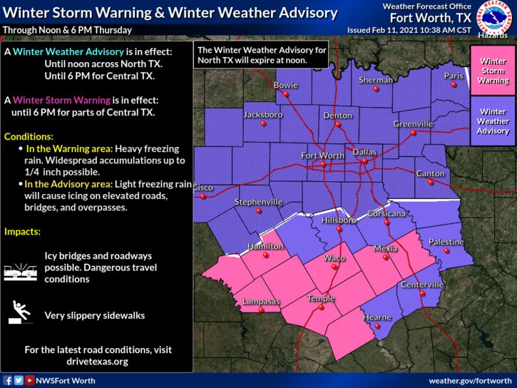 Another great concern is that temperatures will likely have issues rising above the freezing level over the next few days. We have a significant winter storm brewing in the next few days, which would weigh down trees and power lines even more. WINTER STORM EXPECTED FOR MUCH OF TEXAS SUNDAY NIGHT INTO MONDAY - Another surge of arctic air is expected to arrive on Sunday, resulting in a MAJOR temperature drop for ALL of Texas. This is not just cold air that I'm talking about, I am talking about the coldest airmass we have seen in decades. However, most of you are not really concerned about how cold it is going to get next week, but are more focused on the precipitation aspect, so I am going to save the discussion on temperatures for the final part of the blog entry. DISCLAIMER: THIS FORECAST WILL CHANGE, CONSIDERING HOW THE STORM SYSTEM RESPONSIBLE FOR THE EVENTS SUNDAY THROUGH MONDAY WILL NOT ENTER THE AMERICAN UPPER AIR NETWORK UNTIL FRIDAY NIGHT. Long time followers of ApexStorm know that I do not 'hype' these events (sharing the most eye-catching snowfall maps, or posting the worst case scenario) in an effort to get likes, clicks, shares, follows, and retweets. I have been doing this for five years, and know all of the people on Facebook and Twitter that will use scary maps and verbiage to elicit a reaction from the general public. That's not me. I try and share the information I know with the experience I have, explain the uncertainties, what we don't know yet, and go from there. Keep that in mind as you continue reading and as you read the subsequent blogs in coming days. BEHIND THE SCENES: The long-range weather analysis has done an excellent job illustrating this arctic air outbreak over the past two weeks. Guidance in that sector continues to agree on Sunday and Monday. Deterministic weather guidance continues to disagree on snow totals and timing. Like I have said before, looking at deterministic weather output is not helpful at all. This far out, it is best to use ensemble model output, as well as probabilistic forecasts. An ensemble is a set of forecasts that present a myriad of future meteorological possibilities. Each simulation has a slight variant in its' initial conditions and with slightly skewed weather models. These simulations represent uncertainty in the initial conditions and approximations in the models. For a more simple definition, the name is derived from a range of possible weather conditions. The ECMWF-EPS (European Ensemble Model) suggests the chance of snow greater than one inch for North Texas is about 90-100 percent. Meanwhile, the GEFS ( American Ensemble Model) shows the same thing. Point being, confidence is high that a significant winter storm resulting in major impacts over a widespread area late Sunday into early Tuesday morning. TIMING: Snow will be in progress Sunday afternoon and evening over parts of the Texas Panhandle into Northern West Texas. For North Texas, scattered to perhaps widespread sleet is possible throughout the day on Sunday. That being said, you will not see sleet all day, just sleet at times, and certainly might be enough to cause travel issues due to the surfaces already being below freezing. By the overnight hours, snowfall rates will significantly increase and become more widespread out in West Texas as it moves east overnight. SNOW TOTALS AND IMPACTS: Significant snow accumulations are forecast. For now, we are going with 3-6" over the North Texas region. However, based on latest guidance, I may need to raise those numbers in later updates. Gusty winds from the north at around 15-20 mph with gusts of up to 30+ would result in blowing snow and snowdrifts. This will be a scenario where travel will be extremely difficult to near impossible for not only North Texas, but for much of the state. It is looking like 100% coverage for a good part of this event in North Texas. I must remind everyone again, we are still hypothesizing about many of this storm's features, considering how we need it to be in at the US West Coast to get weather balloon data on it, and that will not happen until Friday. That is why I must state again that this forecast will change in the coming days. As we get closer to the event, we will be able to narrow down specific precipitation types, timing, accumulation totals, and temperatures during and after the event. Winter Storm Watches will be issued by the National Weather Service Office in Fort Worth once we are within a few days of the winter storm’s onset. DANGEROUSLY COLD AIR EXPECTED EARLY NEXT WEEK: While a brutally cold airmass is already in place during the winter storm, more arctic air will usher in from the north as the storm exits the region Monday night into Tuesday, creating the coldest airmass Texas has seen in decades. To make matters worse, because extremely cold air will be in place before the snow begins (rare in North Texas) there is a chance many areas will see snowpacks - layers of snow that are incredibly slow to melt. In that scenario, to get a more accurate understanding of what the low temperature may be, subtract five to ten degrees from the numbers on that map. Yes, that would result in near or below zero low temperatures for North Texas on Tuesday, and we are not even talking about the wind chill. Wind chills, in that scenario, would be ten to around 20 degrees below freezing across the region Tuesday morning. Yes, that means danger from the cold will be a real threat, as many will not be informed as to how cold it will really get. Additionally, we could have a real issue with people needing warming shelters if the winter storm results in widespread power outages or stranded travelers.  CRAP APPS: For those who did not see my story on Snapchat yesterday, I have received literally dozens of stories and comments from people telling me what their weather app is showing.
Look, I understand the convenience of the app that is preinstalled on most smartphones. It is insanely convenient! you open it, you are shown a symbol with the high temperature, a low temperature, and a chance of precipitation. In a complex, active winter pattern such as this one, automated apps and websites are pretty much useless 5-6 days in advance (sometimes 24-48 hours as well). They use computer model data which can be absolutely horribly inaccurate in a time like this. They do not provide ANY context, and, most importantly, does not communicate uncertainty at all when forecasting. There is going to be range of possibilities and it takes a little more than a glance at an app on a phone to understand the complex weather pattern that we are in. So, I would use great caution while you are looking at an app, and I will leave it at that. :-) LATER IN THE WEEK: Temperatures will be hard-pressed to rise above freezing across Northern Texas until any snowpacks begin to melt. Speaking of snow, we are tracking another chance of a winter storm across North Texas next Wednesday into Thursday. But, I think I've talked enough for one blog post. BE INFORMED: I know I have many first-time readers here. So I would like to say welcome and thank you for taking the time to read my products! I will have many more as we get closer to this event. If you would like frequent weather updates from me, please follow my Twitter @donowx. Please also like our Facebook page linked here. Also, please join our text messaging system to receive daily forecasts and updates by texting @apexstorm to '81010'. Or click the link. Donovan Neal Owner - ApexStorm WEEKEND UPDATE: Happy Super Bowl Sunday everyone! A great game is slated for today and I think it’d be easier to predict the score of the game than next week’s forecast as there is so much uncertainty. I’ll detail everything you’ll need to know about next week and what to look out for! EARLY WEEK: Monday and Tuesday will be relatively cool days with some overcast skies and occasionally breaks in the clouds. An arctic front will slowly be approaching North Texas as the week progresses so each day will become cooler and cooler. While the initial front will move through Oklahoma on Monday, it won’t make it to DFW until midday Tuesday, as it slowly encroaches upon the region. The arctic air mass is relatively shallow, so while we know it will come into North Texas sometime on Tuesday, it’s hard to know how quickly it’ll move through, and how deep the cold will be. The GFS and Euro have it fizzling out and staying relatively warm (in the 50s and 60s) through Wednesday, whereas the NAM shows a brief warmup period early Tuesday with another drop in temperatures as DFW struggles to get out of the 40s. Typically, models struggle with shallow cold, so expect wild temperature swings in the forecast for the next few days. In addition, some of the mid range models are indicating the potential for freezing drizzle overnight Tuesday into Wednesday as the arctic air seeps its way into Texas. The initial front on Monday/Tuesday won’t have any moisture associated with it but there is a low chance of it occurring overnight Tuesday. However, it’s extremely minimal so don’t anticipate any wintry weather for the first part of the week. ARCTIC BLAST: Cold air has been building up in Canada for a few days as Greenland Blocking and global teleconnections have set up conditions for a proper arctic blast. A ridge of cold air will move southward and make it to NTX sometime later in the week. There are large differences between the models as the ICON and GFS are forecasting extremely cold temperatures (as low as the single digits for Valentine’s Day) due to a stronger front with more arctic air, whereas the Euro slows the progression of the front and limits temperatures. On Wednesday, there’s decent potential for moisture, however most of it will likely be a cold rain. That being said, there is low confidence in a potential ice storm taking place overnight if the air moves quickly enough. In addition, there is some general instability that could facilitate a few thunderstorms south of DFW along the boundary of the air mass. While it’s unclear what will happen with that moisture overnight, it’s likely that it won’t have any travel impacts on the region. It’s generally agreed upon, however, that by Thursday, temperatures will be in the 30s and possibly dip down into the low 20s overnight. And, as the weekend approaches, temperatures are supposed to decline—it’s just unclear by how much. Also, as we shift to a period of cooler temperatures, it’s possible we might have multiple shots at winter weather, with ice storms, freezing rain, and snow all shown as a possibility over the next 10 days, with multiple chances for precipitation. It’s hard to hone in on one example due to high model disagreements over the progression of the arctic airmass and global oscillations that affect larger air mass movements and pressure systems. Ensemble guidance is promising but continues to change, so it will be something to monitor as we progress through the week. For now, enjoy the last few mild days as it starts to get colder next week. Stay warm, stay safe, and stay weather aware! -Colin Welty
|
Archives
April 2024
Categories |


 RSS Feed