
|
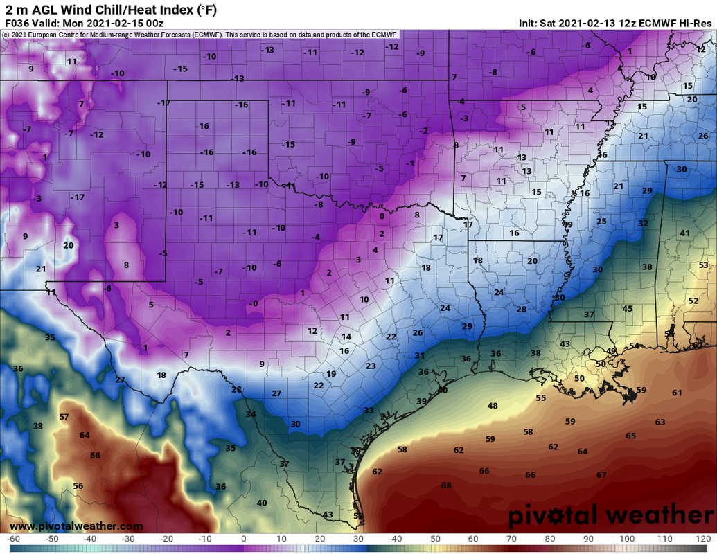
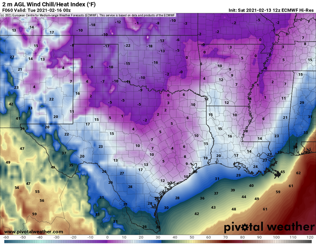
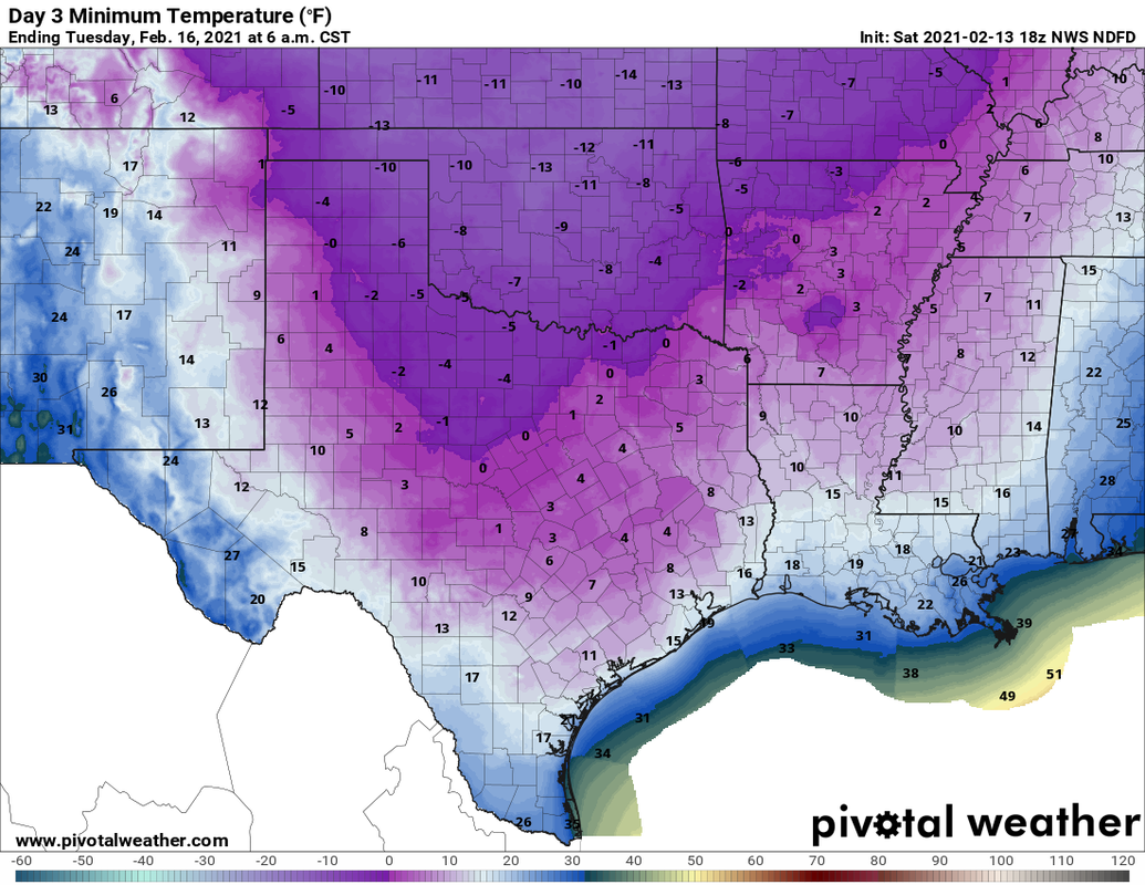
Before I talk about this region specifically, I would like to point out that Winter Storm Watches or Warnings are in effect for ALL counties of Texas. The entire state of Oklahoma is under a Winter Storm Warning... 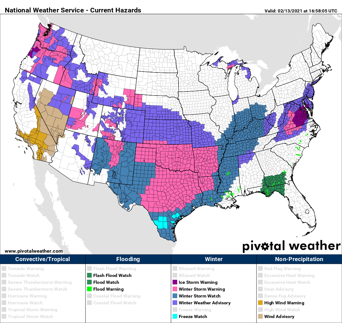 Persons within a winter storm watch will likely be upgraded to a Winter Weather Advisory or a Winter Storm Warning later this afternoon or evening. However, I encourage you not to get hung up on the exact verbiage of these advisories. The main point is, we are expecting accumulating winter precipitation and brutally cold weather across ALL of Texas over the next several days. WEATHER FORECAST HEADLINES - This is probably the most strongly worded headlines I will probably ever write during my time forecasting the weather. The truth is, we have not seen such potential for a winter weather event of this magnitude since the Arctic Outbreak of 1989. With the combination of a winter storm that has the potential to bring snowfall, blizzard-like conditions, freezing rain, and sleet for pretty much everywhere in the Lone Star State, followed by the coldest airmass we have seen in more than three decades, this leads me to conclude that this is a generational event; an event that tends to happen once every 30 years.  FIRST CALL SNOW ACCUMULATIONS - We continue to forecast significant amounts of snow for the northern two thirds of Texas late tonight through Monday morning. Just like I said I would, we went ahead and delayed making a snowfall map until this morning at the earliest since the storm is in the West Coast now. Here is our first official snowfall accumulation map, made today at 11:00 AM... 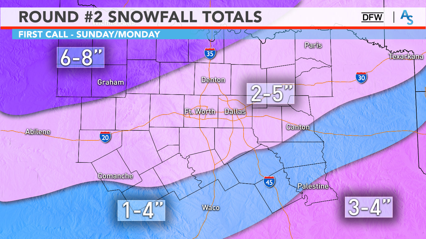 Regarding amounts, it’s still a bit shaky. Keep in mind that this is still on the conservative side of the spectrum, and that any location on this map can see a lot more than forecast. Our NW counties could see 6+ inches of snow, with 2-5” likely in the Metroplex. Yes, it is possible some you see only an inch, some of you may even see 6 inches. It is a wide range due to banding and it is nearly impossible for us to predict, but 100% of North Texas will see snow tomorrow. A good range for us is 2-5 inches with isolated higher and lower totals possible. With temperatures likely in the teens tomorrow afternoon, all this snow will accumulate very easily and travel will be near impossible. Due to gusty north winds and powdery snow, blowing snow will be threat tomorrow and on Monday, even when it’s not snowing. The winter storm warning continues until 6pm on Monday. It is important to note that this storm will not follow these specific guidelines at all. Some places may see more or less snow than what is presented in this forecast, but I think this is a good map; a map that will give everyone in the region an idea of how much snow they can REASONABLY expect. Understand that this map can and will change, even within the next 12 hours. We will probably have another one of these made before you go to bed today. WHAT MAKES THIS WITNER STORM SO DIFFERENT FROM OTHERS WE HAVE SEEN? - Temperatures are currently way below freezing, and will continue to stay that way for a very long time, probably through Thursday. As a result, this winter storm will not be a southern-style winter storm where it snows, and we see roads turn perfectly normal within a few hours of the snow ending. Like I said in yesterday's discussion, this will be a Midwestern style winter storm, where surface temperatures are already below freezing. As a result, anything that falls from the sky, whether it is snow, sleet, freezing rain, etc., will have no problems freezing over, sticking, and turning into ice skating rinks. Additionally, because the air is much drier than with typical snow events in Texas, snow will weigh much lighter. Combined with north sustained winds of 10-20 mph with higher gusts at times, you now mention the issue of blowing snow and near-blizzard conditions, especially for the northern two-thirds of the state. This is exactly why we have been stressing over the fact that travel will become impossible Sunday through at least Tuesday. TIMING: Timing has changed significantly over the past few days. We will be dealing with two storm systems in the next few days. It is now looking like the main event for North Texas from storm #2 will come throughout Sunday, lasting all the way through Monday morning. 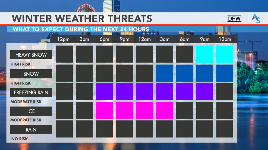 Our first storm system that will affect us is weaker but will be strong enough to sneeze a little winter precipitation before the main storm's onset. Freezing drizzle and rain, and light snow may occur this evening and overnight across North Texas before the main event Sunday morning. While this isn't the main event yet, it is best to not travel when this occurs. Freezing rain creates a glazing of ice on the roads, and it does not take a winter storm to cause major issues on the road ways. The main system will move east overnight, and we could see snow for our far west and northwestern counties as early as the predawn hours tomorrow. Moderate snow should be moving into North Texas, including the DFW metroplex by tomorrow afternoon. Then, a full-fledged mess will unfold for the region by late afternoon tomorrow through tomorrow evening. Most of the snow should be out of the region by Monday afternoon Untreated roads will probably stay undriveable through Wednesday evening at the very, very earliest. HISTORICALLY COLD TEMPERATURES AFTER STORM #2 - As if we weren't cold enough, another brutally cold arctic airmass moves southward on the backside of the departing storm system. This, combined with the cold we are already experiencing, will set the stage for the coldest conditions we have seen in decades by Tuesday morning.
The only way the roads will improve before Wednesday or even Thursday when they get plowed or sanded. Even then, most back roads or untreated roads in residential communities will remain hazardous.
BUT WAIT, THERES MORE! - Another potent upper level storm system will move across the state Tuesday night and Wednesday. Since we have the arctic airmass in place already, this could result in another significant winter storm for North Texas. In addition to what we see with storm #2, several inches of snow is possible for our region again. In fact, this system might be the wetter one with moisture, causing wetter snow and more precipitation than storm #2! This is why I am so adamant that conditions won't start improving until Thursday at the earliest. We will revisit this once we get past tomorrow and Monday. AFTER IT ALL ENDS: - We will be dry for a minute and start slowly increasing in temperature after Wednesday. Even then, we will not see temperatures above freezing until at least Thursday, if the snowpacks melt during that time. CONNECT - You can find me on all social networks... ApexStorm Text Messaging Join Link Donovan Neal Owner - ApexStorm |
Archives
March 2023
Categories |
 RSS Feed
