
|
FREEZING LINE: The freezing line is south to a line from Marathon to Rocksprings to Boerne to Giddings to Jacksonville to Clarksville. The line represents where temperatures are 32° or below, or, for simple terms, where it is below freezing. As you can see, a majority of the Lone Star State fits under that category right now... 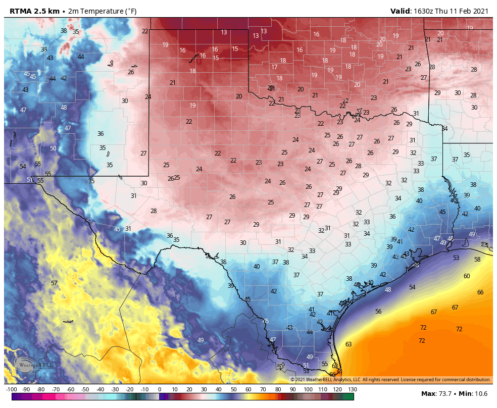 As we saw this morning, the rain, combined with below freezing temperatures, resulted in freezing rain causing ice accretion on several major highways, roads, bridges, and overpasses. Dozens of accidents were reported this morning across the region, and they still continue to come in. A mass casualty incident is taking place in Fort Worth on I-35W just after I-30, where a 100 car pileup occurred, resulting in at least six fatalities.
Fortunately, for the DFW Metroplex, freezing rain has tapered off for the most part, and will continue to do so throughout the afternoon. That should prevent new issues of icy bridges for the rest of the day. The Winter Weather Advisory for DFW will expire at noon today. At the same time, freezing rain will continue for some of our southern North Texas counties, where it will be their turn to experience freezing rain and ice accumulation. FREEZING RAIN CONTINUES THIS AFTERNOON IN SOUTHERN NORTH TEXAS - There are increasing concerns over ice accumulation over than a quarter of an inch over much of Southern North Texas and Central Texas this afternoon. This will lead to not only hazardous travel, but extensive tree damage and power outages. A Winter Storm Warning has been issued for the counties outlined in magenta on the graphic below to address this concern. 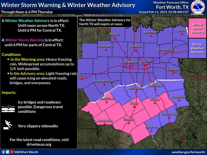 Another great concern is that temperatures will likely have issues rising above the freezing level over the next few days. We have a significant winter storm brewing in the next few days, which would weigh down trees and power lines even more. WINTER STORM EXPECTED FOR MUCH OF TEXAS SUNDAY NIGHT INTO MONDAY - Another surge of arctic air is expected to arrive on Sunday, resulting in a MAJOR temperature drop for ALL of Texas. This is not just cold air that I'm talking about, I am talking about the coldest airmass we have seen in decades. However, most of you are not really concerned about how cold it is going to get next week, but are more focused on the precipitation aspect, so I am going to save the discussion on temperatures for the final part of the blog entry. DISCLAIMER: THIS FORECAST WILL CHANGE, CONSIDERING HOW THE STORM SYSTEM RESPONSIBLE FOR THE EVENTS SUNDAY THROUGH MONDAY WILL NOT ENTER THE AMERICAN UPPER AIR NETWORK UNTIL FRIDAY NIGHT. Long time followers of ApexStorm know that I do not 'hype' these events (sharing the most eye-catching snowfall maps, or posting the worst case scenario) in an effort to get likes, clicks, shares, follows, and retweets. I have been doing this for five years, and know all of the people on Facebook and Twitter that will use scary maps and verbiage to elicit a reaction from the general public. That's not me. I try and share the information I know with the experience I have, explain the uncertainties, what we don't know yet, and go from there. Keep that in mind as you continue reading and as you read the subsequent blogs in coming days. BEHIND THE SCENES: The long-range weather analysis has done an excellent job illustrating this arctic air outbreak over the past two weeks. Guidance in that sector continues to agree on Sunday and Monday. Deterministic weather guidance continues to disagree on snow totals and timing. Like I have said before, looking at deterministic weather output is not helpful at all. This far out, it is best to use ensemble model output, as well as probabilistic forecasts. An ensemble is a set of forecasts that present a myriad of future meteorological possibilities. Each simulation has a slight variant in its' initial conditions and with slightly skewed weather models. These simulations represent uncertainty in the initial conditions and approximations in the models. For a more simple definition, the name is derived from a range of possible weather conditions. The ECMWF-EPS (European Ensemble Model) suggests the chance of snow greater than one inch for North Texas is about 90-100 percent. Meanwhile, the GEFS ( American Ensemble Model) shows the same thing. Point being, confidence is high that a significant winter storm resulting in major impacts over a widespread area late Sunday into early Tuesday morning. TIMING: Snow will be in progress Sunday afternoon and evening over parts of the Texas Panhandle into Northern West Texas. For North Texas, scattered to perhaps widespread sleet is possible throughout the day on Sunday. That being said, you will not see sleet all day, just sleet at times, and certainly might be enough to cause travel issues due to the surfaces already being below freezing. By the overnight hours, snowfall rates will significantly increase and become more widespread out in West Texas as it moves east overnight. SNOW TOTALS AND IMPACTS: Significant snow accumulations are forecast. For now, we are going with 3-6" over the North Texas region. However, based on latest guidance, I may need to raise those numbers in later updates. Gusty winds from the north at around 15-20 mph with gusts of up to 30+ would result in blowing snow and snowdrifts. This will be a scenario where travel will be extremely difficult to near impossible for not only North Texas, but for much of the state. It is looking like 100% coverage for a good part of this event in North Texas. I must remind everyone again, we are still hypothesizing about many of this storm's features, considering how we need it to be in at the US West Coast to get weather balloon data on it, and that will not happen until Friday. That is why I must state again that this forecast will change in the coming days. As we get closer to the event, we will be able to narrow down specific precipitation types, timing, accumulation totals, and temperatures during and after the event. Winter Storm Watches will be issued by the National Weather Service Office in Fort Worth once we are within a few days of the winter storm’s onset. DANGEROUSLY COLD AIR EXPECTED EARLY NEXT WEEK: While a brutally cold airmass is already in place during the winter storm, more arctic air will usher in from the north as the storm exits the region Monday night into Tuesday, creating the coldest airmass Texas has seen in decades. To make matters worse, because extremely cold air will be in place before the snow begins (rare in North Texas) there is a chance many areas will see snowpacks - layers of snow that are incredibly slow to melt. In that scenario, to get a more accurate understanding of what the low temperature may be, subtract five to ten degrees from the numbers on that map. Yes, that would result in near or below zero low temperatures for North Texas on Tuesday, and we are not even talking about the wind chill. Wind chills, in that scenario, would be ten to around 20 degrees below freezing across the region Tuesday morning. Yes, that means danger from the cold will be a real threat, as many will not be informed as to how cold it will really get. Additionally, we could have a real issue with people needing warming shelters if the winter storm results in widespread power outages or stranded travelers.  CRAP APPS: For those who did not see my story on Snapchat yesterday, I have received literally dozens of stories and comments from people telling me what their weather app is showing.
Look, I understand the convenience of the app that is preinstalled on most smartphones. It is insanely convenient! you open it, you are shown a symbol with the high temperature, a low temperature, and a chance of precipitation. In a complex, active winter pattern such as this one, automated apps and websites are pretty much useless 5-6 days in advance (sometimes 24-48 hours as well). They use computer model data which can be absolutely horribly inaccurate in a time like this. They do not provide ANY context, and, most importantly, does not communicate uncertainty at all when forecasting. There is going to be range of possibilities and it takes a little more than a glance at an app on a phone to understand the complex weather pattern that we are in. So, I would use great caution while you are looking at an app, and I will leave it at that. :-) LATER IN THE WEEK: Temperatures will be hard-pressed to rise above freezing across Northern Texas until any snowpacks begin to melt. Speaking of snow, we are tracking another chance of a winter storm across North Texas next Wednesday into Thursday. But, I think I've talked enough for one blog post. BE INFORMED: I know I have many first-time readers here. So I would like to say welcome and thank you for taking the time to read my products! I will have many more as we get closer to this event. If you would like frequent weather updates from me, please follow my Twitter @donowx. Please also like our Facebook page linked here. Also, please join our text messaging system to receive daily forecasts and updates by texting @apexstorm to '81010'. Or click the link. Donovan Neal Owner - ApexStorm |
Archives
March 2023
Categories |


 RSS Feed
