
|
RADAR CHECK: A complex of showers and thunderstorms are moving to the southeast across North Texas this morning. This is just a period of light to moderate rain with no severe and probably very little thunder. These storms should clear by the afternoon, and we should be in the mid 80s for the rest of the day with a mix of sun and clouds. Not much change for the weekend; each day will feature a mix of sun and clouds with a chance of either widely scattered showers and storms or a complex of storms in the morning/early afternoon. Highs each day will be in the 87-91 degree range. NEXT WEEK AND BEYOND: Relatively dry weather will continue for most of the week, but each day will feature at least some chance of showers and storms during the morning/afternoon hours. Afternoon highs for much of the week will be in the upper 80s to low 90s; around seasonal averages for this time of the year. Global model data suggests we will continue to see the opportunity of widely scattered showers and storms through mid-June. See the Texas Weather Discussion Video for more details.   DROUGHT MONITOR: The new drought monitor data this morning shows drought conditions starting to creep back into parts of south and southwest Texas. Most of the state is drought free as a result of the severe weather and rain over the course of the last two months. 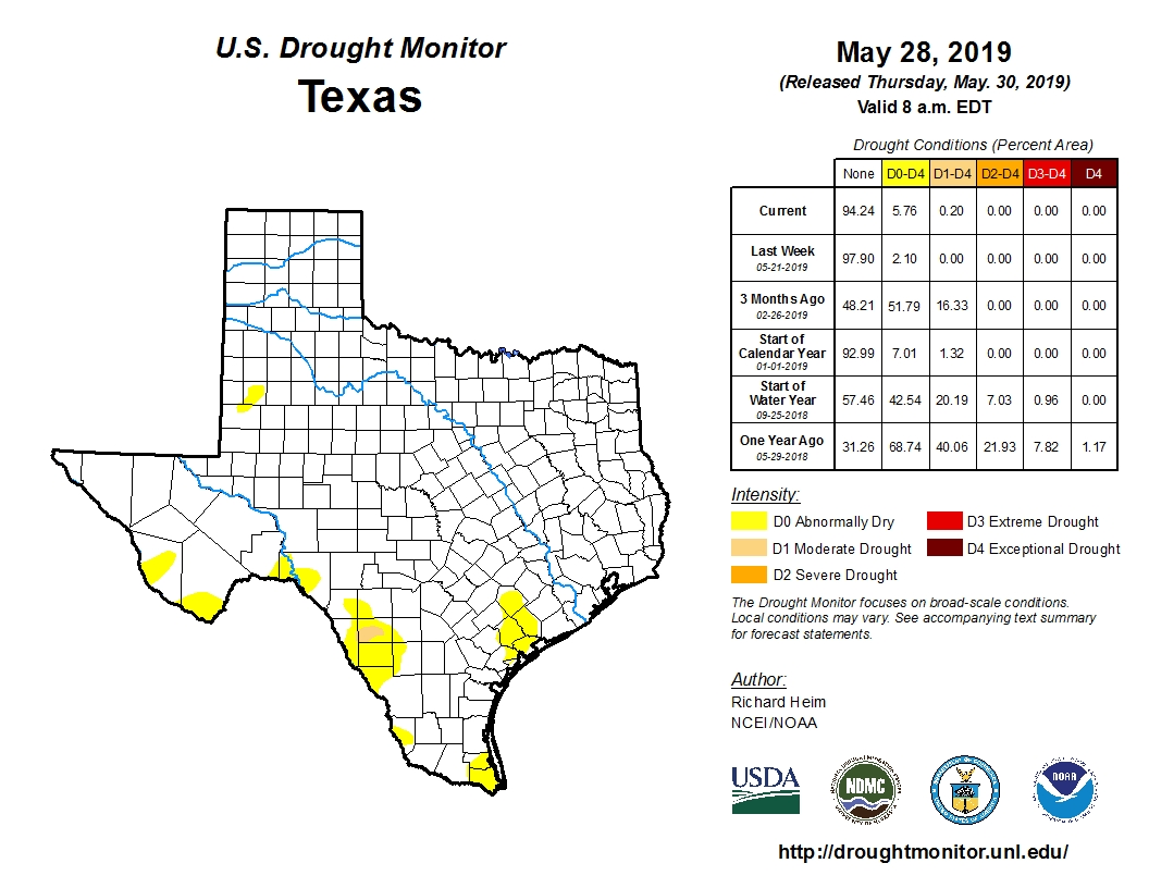 ON THIS DAY IN 2013: A massive EF3 tornado occured over the rural areas just outside of Oklahoma City. This was the widest tornado in recorded history, and was a part of a multi-day tornado outbreak. The tornado touched down southwest of El Reno as it rapidly grew in size and became more violent as it track through central Canadian county. Since the tornado remained over mostly open terrain, it did not impact many structures. However, measurements from mobile radars found 301 mph winds inside of the tornado, the second highest observed wind speeds on Earth, with the May 3rd, 1999 Bridge Creek, Moore tornado only exceeding that number by a margin.
This tornado is also known for killing four storm chasers, the first known deaths in the history of storm chasing. Although the tornado tracked through open terrain, many chasers were caught off guard with the size and movement of the tornado. Near the vicinity of Highway 81, scientist and engineer Dr. Tim Samaras, with his son Paul Samaras and research partner Carl Young, died in the tornado. Paul and Young were ejected from their Chevrolet Cobalt by the tornado's vortex, while Tim still had his seatbelt in the passenger seat. VERY LITTLE CHANGE THROUGH THE WEEKEND: The overall weather pattern won't change much through the weekend for North Texas, but we will mention the chance of a few isolated to widely scattered showers and storms tomorrow through the weekend. Only one in five locations will get wet, otherwise, today will feature a mix of mostly sun and clouds with highs in the mid 80s, a few degrees below our average high of 88°. Look for mostly dry weather tomorrow, Saturday, and Sunday with mostly sunny days with calm nights. We go back to seasonals averages with highs in the upper 80s to low 90s. NEXT WEEK: Most locations will be dry throughout the week, but each day will feature a chance of isolated showers and storms through Thursday. Afternoon highs much of the week will be in the upper 80s to low 90s. See the Texas Weather Discussion Video for more details.  VERY ACTIVE AFTERNOON AHEAD: You will want to pay attention to the weather over the next 24 hours as we will have the dual threat of some flash flooding and severe thunderstorms this afternoon and evening. CALM BEFORE THE STORM: As advertised, a cluster of ongoing severe storms to the west of the metroplex is starting to turn more to the north with time. The chance of severe storms is low, but not zero this morning across the metroplex. We are currently "lull" right now, as we have sun and few clouds over the metroplex currently. Our real threat for severe storms does not begin until the afternoon. ROUND ONE: A complex of severe storms are currently ongoing for areas just to the west of the DFW Metroplex, and is moving to the east-northeast at 45 mph. One or two of these storms could turn severe with strong, straight-line winds and hail up to the size of quarters possible. For here, the sun has been breaking out in some places, and temperatures will rise to the upper 80s in some spots by the afternoon. With dewpoints in the upper 70s currently, this will make for a very unstable, volatile airmass by the mid afternoon hours. ROUND TWO: New storms could begin to form as early as 12:00 PM today over the North Texas region ahead of the complex of storms in the increasingly unstable air, and as dynamic support increases, we will have a risk of severe storms through this late evening. TIMING: We will focus on the broad 12 hour window from 12:00 PM until 12:00 AM. Supercell development could begin as early as 11:00 AM this morning (you will need to pay attention to all warnings throughout this morning and afternoon), but the better combination of dynamics and thermodynamics will come this mid-afternoon into the early evening hours. PLACEMENT: The SPC has defined an "enhanced risk" of severe weather for all of North-Central Texas and for our adjacent states to the northeast with the standard "slight risk" of severe storms encompassing much of Central and West Texas, including Abilene and San Antonio. The highest tornado probabilities are in the enhanced risk, and a strong tornado or two is not out of the question for North Texas. But, be advised that a tornado is possible anywhere in the state today. 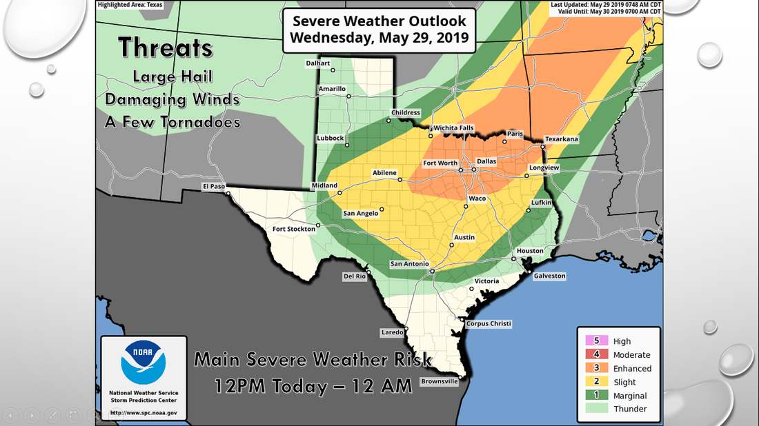 MODES: In addition to tornadoes, severe thunderstorms will primarily produce very large hail. The damaging wind threat will come in the late afternoon/early evening hours. FLOODING: A flash flood watch remains in effect for much of the North Texas area through tonight; average rainfall amounts of 2-3 inches are likely, with isolated totals to 4 inches. This could create localized flash flooding. CALL TO ACTION: Be sure you can hear severe weather watches and warnings this afternoon, and know where you are going if you are under a tornado warning polygon. And, be sure you have a readiness kit in your safe place, including helmets, air horns, and hard sole shoes. For more informations, including thoughts on apps for your phone, please see this post. TOMORROW: Once the severe weather clears, we will transition to our very mild pattern with a mix of sun and clouds with occasional isolated showers and storms. Highs will be in the mid to upper 80s. THE WEEKEND: Not much change. Sunny, mostly pleasant days and clear, mild nights. We project seasonal temperatures with highs in the upper 80/low 90 degree range. NEXT WEEK: The weather for much of next week will feature highs in the low 90s with mostly sunny skies and pleasant weather. Occasional showers and storms are possible on Monday and Thursday. See the Texas Weather Discussion Video for more details. 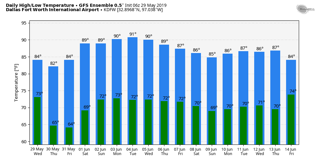 LATE MAY SEVERE WEATHER THREAT - As we head towards the beginning of the start of Meteorological Summer (June 1), this is usually where severe weather activity is the highest in the Plains. This year is no exception. There have been 288 confirmed tornadoes so far in May, with 15 of them being intense EF3 tornadoes. Luckily, we are not looking at a tornado threat this time, but it could be another stormy evening. The Storm Prediction Center has expanded the "enhanced risk" (level 3 of 5) of severe storms to include the DFW Metroplex and points to the north and east, away from the state. The standard "slight risk" (level 2 of 5) of severe storms includes areas to the outside of the DFW Metroplex, including West and Central Texas. 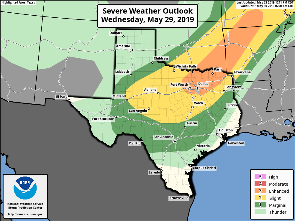 Just with any severe weather threat, please be advised that this is a guideline and storms do not know or follow any of these risk lines; all of North and Central Texas has some chance of seeing severe weather tomorrow. TIMING: Some isolated storms are possible in the late morning hours, but severe storms will develop around the 1-3PM timeframe. The complex of severe storms will affect the metroplex at around 4PM-11PM time frame. Although some isolated storms will develop, most of it will come in a form of supercells. THREATS: Since a mess of severe thunderstorms is our primary concern this time, the tornado threat is relatively low, but not zero due to the abundance of storms expected. Even if supercells develop, the main threat would be very large hail (up to tennis ball size) and damaging winds. If the storm takes a more "linear" mode, the damaging wind threat will be the most robust. Some gusts have the potential of reaching tornado-like wind speeds with the most intense parts of the complex. RAIN: The secondary threat Wednesday evening will come from heavy rain. Rainfall amounts of 2-3 inches overall is possible. With the possibility of locally higher amounts with any slow moving storms, a Flash Flood Watch (dark green) has been issued for some counties in North Texas to address this possibility.  CALL TO ACTION: This is just like any other threat of severe weather here in the Southern Plains. Just make sure you have a way of receiving weather warnings on your phone by having a good weather warning app. If you happen to be under a severe thunderstorm warning, just be sure to distance yourself from any doors and windows in case of hail or damaging wind. And, of course, if you are in a tornado warning, seek shelter in your interior room on the lowest part of your home, away from windows.
Be sure to follow my twitter @apex_dfw_wx for any further updates this evening and tomorrow. CALM BEFORE THE STORM: As forecast, temperatures are already in the middle 70s across North Texas this morning, which are high temperatures you would typically see on a good spring day. Like I said in the video, when temperatures are that high this early, you already know days like this will be pretty bad for some. Due to an abundance of moisture, some fog is possible in some communities this morning. Today will also be particularly windy, and a Wind Advisory is in effect for all of the North Texas region today. We will be in the upper 80s today. TORNADO OUTBREAK EXPECTED ACROSS NW TEXAS AND OKLAHOMA: The large scale features is indicative of a classic Plains tornado outbreak scenario across Oklahoma and Northwest Texas. A surface low that's on the Colorado, NM border will also be supported by a deep upper trough and strong shearing. Forecast surface based CAPE values (instability measure) are expected to soar into the 4,000-6,000 j/kg range, making for a "powder keg" and a "loaded gun" situation by the afternoon hours. The SPC has placed parts of NW Texas and much of Western Oklahoma in a very rare "High Risk" (level 5/5) of severe weather. This is the first high risk day since May 2017 and only the third time a high risk has been issued under the five tier categorical outlook system. Usually a high risk is issued when there is great confidence of a major severe weather and/or tornado outbreak for that zone. That is what we are seeing this morning... 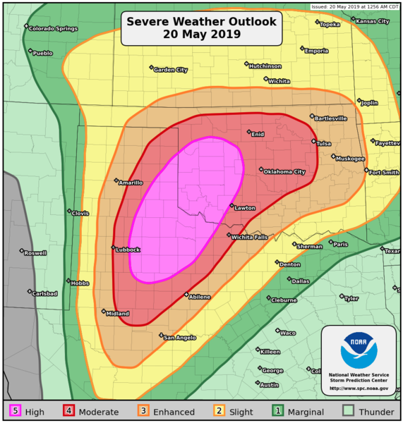 Although there is the high risk in place, I advise you to not get caught up in looking at these risk maps as this is just simply a guideline; storms do not read these maps and certainly don't know where these exact lines are. Just realize that all of the Southern Plains is at a significant risk of a major tornado outbreak this afternoon and evening. TIMING/THREATS: There will be multiple waves of storms and severe weather throughout the day. The primary threat with the ongoing morning storms out in the Texas Panhandle currently is hail and strong, gusty winds. Storms from around 12PM to 12 AM Tuesday morning will be capable of producing very large hail, very damaging winds, and the potential for violent, long-track tornadoes, especially in the High and Moderate risk zones. RAIN: Heavy rain will be the second biggest threat today across Central Oklahoma, and rainfall amounts anywhere from 2-9" with locally higher amounts are likely. Flash Flood Watch is in effect for most of the Oklahoma state. CALL TO ACTION: Right now, make sure you have a way of receiving warnings at a moments notice, NOAA weather radio is the baseline, but a good smartphone app is the next level of prepardness. Identify your safe place in your home or business, and ensure everyone knows where it is. In that safe place, make sure you have helmets and hard-sole shoes for everyone, and a whistle and portable airhorn in case you need help. A full detailed list of severe weather safety information can be found here. TAKE ONE DEEP BREATH: This is the peak of spring tornado season here in the plains, and severe weather threats are very common here, nothing unusual like today. However, we have had a quiet 3-5 years compared to years past, and we all knew it couldn't stay quiet forever... just make sure you have a way of receiving warnings, have a plan of action, and prepare a good readiness kit in your safe place and you will ride this outbreak out just fine. Also, keep in mind that there is always the potential that this outbreak could "bust", which is best described as a situation where storms are not as severe as forecast. Be advised that it takes multiple factors to come together in one place and time for tornadoes to develop. REST OF THE WEEK FOR NORTH TEXAS: North Texas will continue mentioning mostly dry weather for the next week. Some storms are possible tomorrow morning, but most of the week will feature mostly sunny skies and a few clouds with highs in the upper 80s. THE WEEKEND: Not much change, the weekend will feature seasonal temperatures with mostly sunny skies. Highs will be in the mid 80s. NEXT WEEK: Not much change, seasonal temperatures will continue along with sunshine and smiles. See the Texas Weather Discussion Video for more details. 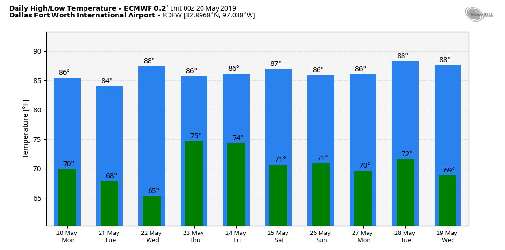 ON THIS DAY IN 2013: A large and extremely violent EF-5 tornado tore through parts of Moore, Oklahoma and adjacent areas, with peak winds estimated at around 210 mph, killing 24 people and injuring 212 others. This was the latest EF5 tornado recorded in the US, and that part of Oklahoma has a risk of violent tornadoes today.
WARM MORNING: Just like the past few days this week, temperatures are in the upper 60s with even a reading of 70° already this morning. With mostly sunny skies, we will mention highs in the mid to upper 80s again today, still about 5 to 6 degrees above our average high for May 16. A few clouds roll in here by Friday, and we will mention a mix of sun and clouds with breezy conditions during the afternoon. Humidity levels will stay the same, and highs will remain in the mid to upper 80s. THE WEEKEND: As advertised, a potent storm system from West Texas will more than likely bring severe weather to the North-Central Texas region from late Saturday morning through the afternoon hours. The SPC has already issued the "enhanced risk" (level 3 of 5) of severe storms for areas to the southeast of the immediate greater DFW Metroplex, although this does include Dallas. The standard "slight risk" (level 2 of 5) of severe storms exists for areas elsewhere. 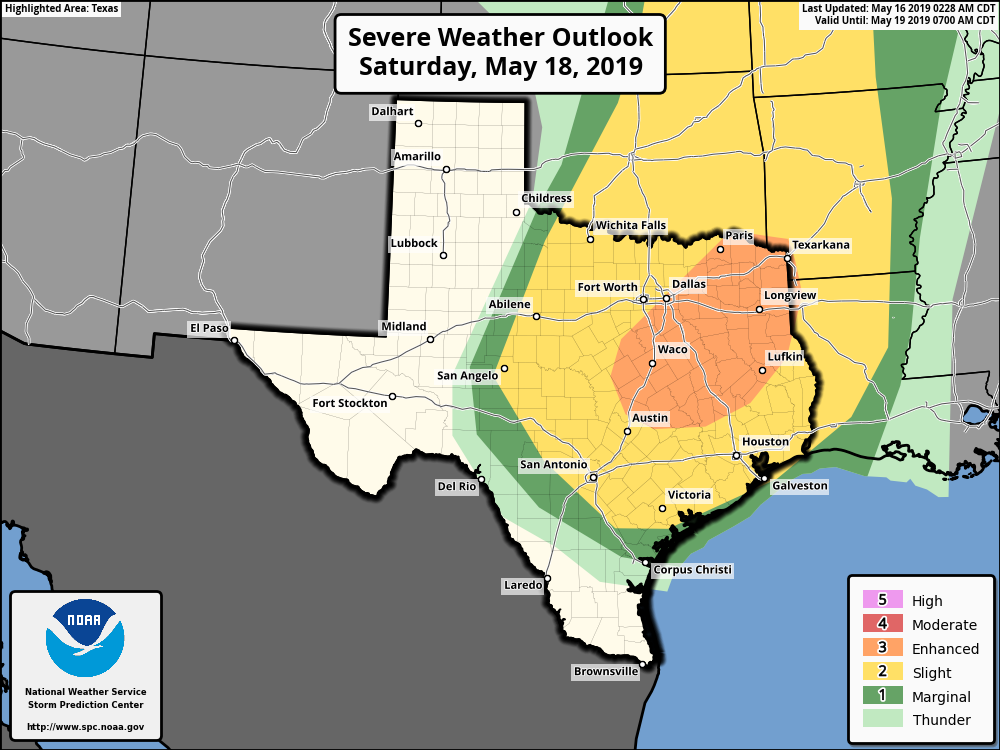 TIMING: An MCS (mesoscale convective system) is likely to roll through the region from the west and northwest during the late morning and afternoon. Severe storms are possible anywhere from 9AM through 9PM Saturday. THREATS: Instability and helicity values continue to indicate the potential for all modes of severe weather, including some supercells mixed into the squall line. Damaging winds, large hail, and a few tornadoes all seem possible, especially in the Enhanced risk area. Once severe storms clear the state, we should be mostly nice and dry overnight with lows in the upper 60s and highs in the mid 80s on Sunday with mostly sunny skies. NEXT WEEK: After the possibility of showers and more severe storms on Monday and Tuesday, the rest of the week looks very dry and warm as an upper level ridge builds over the south-central US. Highs will continue to be in the mid 80s as that hot and dry pattern continues through Memorial Day weekend. See the Texas Weather Discussion Video for more details.  MILD MORNING: Temperatures are currently in the middle to upper 60s already this morning as the humidity is increasing. The sky will be mostly sunny, and highs will be in the middle 80s later this afternoon. The sky will continue to stay fair tonight, and we project a morning low in the mid to upper 60s again tonight. REST OF THE WEEK: The weather turns slightly warmer and more humid; look for highs in the mid 80s tomorrow and Friday. Some clouds will return on Friday with an approaching storm system, but rain chances will continue to be non-existent. ACROSS THE PLAINS: A very active pattern of severe weather is developing for parts of the Central and Southern Plains and the Mississippi River Valley region over the next 7 to 10 days. This marks the first time the SPC has a highlighted area of severe weather for all but one day with a 15% or greater probability of severe weather occuring. 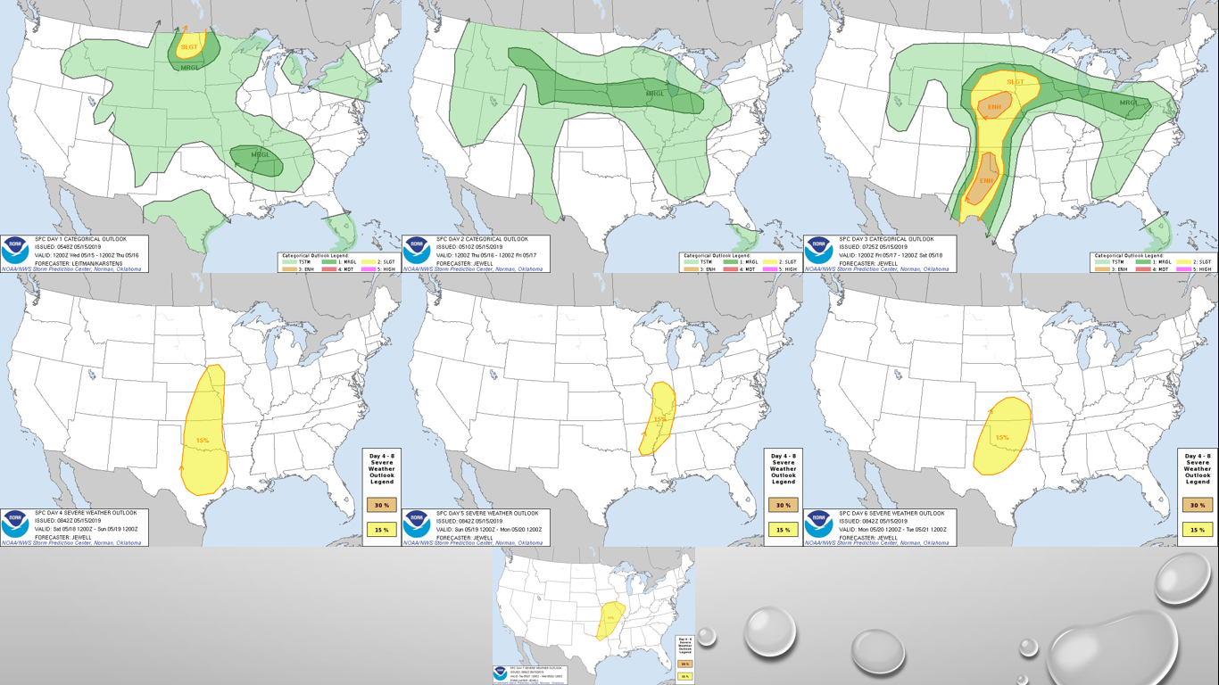 Our days to watch for North Texas is Saturday (Day Four) and Monday (Day Six). Saturday will feature more of a damaging wind event, but a few tornadoes are still possible in the storms that are more supercellular. Tornadoes and damaging winds are possible on Monday. The damaging wind threat will increase throughout Monday evening as storms begin to congeal and move to the east. The exact timing and placement of the storms are unknown at this time, as these events are still far too early to pinpoint specifics. Just know that everyday, somewhere will see severe weather for at least the next week. NEXT WEEK: After some severe weather on Monday leading into parts of Tuesday, expect some severe clear for the rest of the week with afternoon highs well in the mid to upper 80s for the latter half of the week. See the Texas Weather Discussion Video for more details. 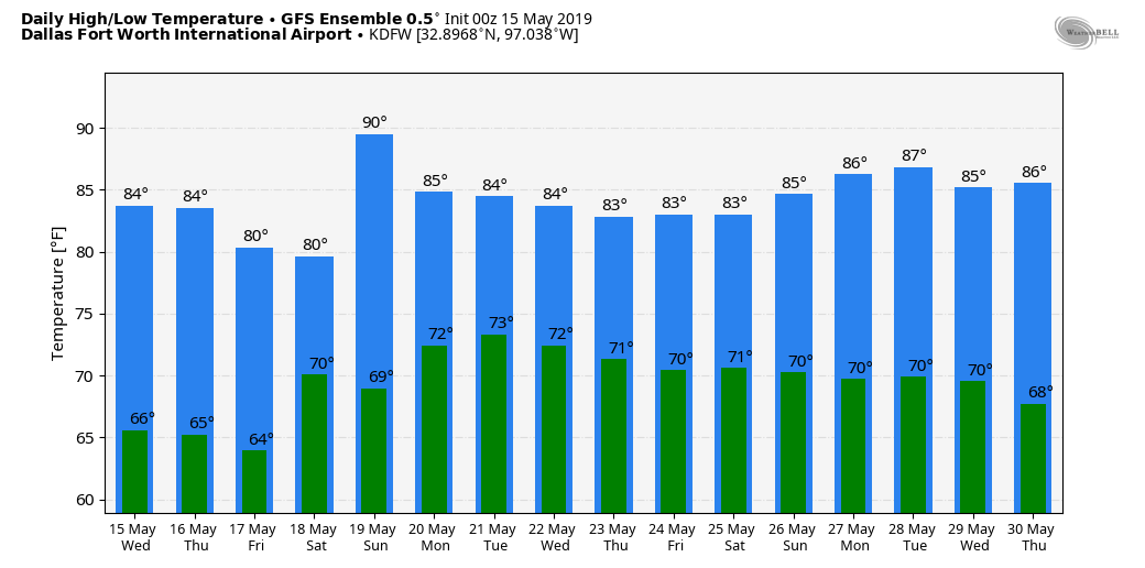 ON THIS DAY IN 1923: An early morning F5 tornado cut a 45 mile path of destruction through Howard and Mitchell counties. 23 people passed away and 250 were injured. The width of the tornado reached 1.5 miles at one point, and the entire farms were literally "wiped off the face of the Earth". The First Baptist Church in Colorado City became an emergency hospital for victims.
ANOTHER WARM MORNING: Like always, temperatures are in the upper 50s to low 60s across the metroplex this morning. Expect mostly sunny skies with afternoon highs in the mid 80s. REST OF THE WEEK: The rest of the week will feature a pattern where the weather doesn't change much for North Texas. Each day will feature mostly sunny skies with increasingly humid conditions with highs in the mid 80s throughout the week. Friday will be breezy with more of a mix of sun and clouds. THE WEEKEND: A dynamic storm system will bring the chance of severe weather during the afternoon and evening on Saturday for North Texas and much of the Southern and Central Plains. The SPC has already outlined a risk of severe weather for their Day 5 Outlook, and will probably introduce higher probabilities as confidence increases. 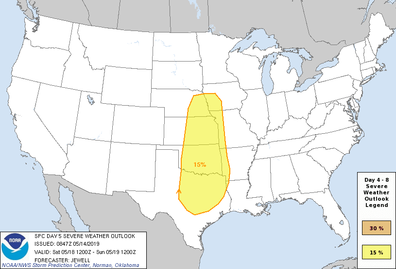 At this point, it is still too early to pinpoint any specifics regarding timing, threats, and placement. Just know that there is a chance for stormy weather on Saturday, and you should keep close tabs on the forecast. We completely clear the state of any storms on Sunday, and should subsequently be a really nice day with afternoon highs in the mid 80s and mostly sunny skies. NEXT WEEK: An upper level ridge builds across the Southern US, and we will continue to maintain dry conditions for much of next week with highs mostly in the mid 80s with mostly sunny skies... See the Texas Weather Discussion Video for more details. 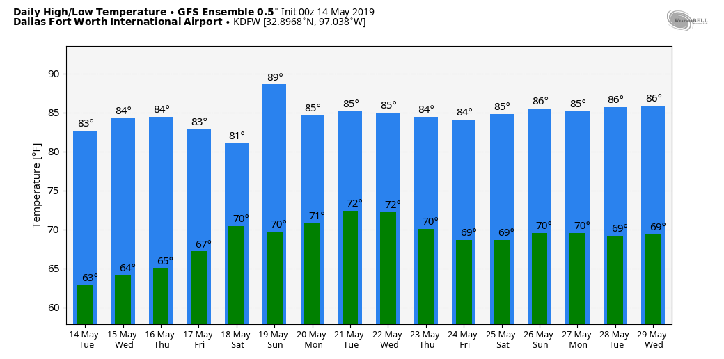 DRIER AIR STILL IN PLACE: After an unsettled period of wet weather Friday night through Saturday afternoon, drier air is still in North Texas today. The sky will feature partly to mostly sunny skies with a high in the low 80s, which is actually where are seasonal averages are at. The average high for DFW for May 13 is 83°. Tonight will remain dry and fair with many places ending up in the low 60s again. The day will feature a mix of sun and clouds with rain showers possible for our southwestern counties. The high will remain in the low 80s. REST OF THE WEEK: Not much change. Each day will feature mostly sunny skies and breezy conditions with afternoon highs in the mid 80s. We will see a notable increase in humidity each day. THE WEEKEND: Another storm system is due in here on Saturday, and severe storms will be possible on that day. The SPC has already issued a risk of severe weather for Central Texas extending into Southern Kansas. This includes all of the North-Central Texas area. 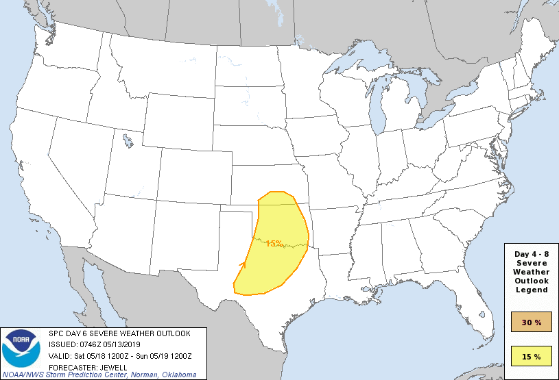 There is still significant model spread concerning the storm mode during the afternoon and evening. At this point, is it far too early to pinpoint any specific threats, timing, and placement of the storms. This just serves as a heads-up going into the weekend. Then we clear the state of any rain on Sunday. We will stay mostly sunny with highs in the mid 80s on both days. NEXT WEEK: The beginning of next week looks tranquil with afternoon highs in the mid 80s. No signs of any hot 90° for the time being. See the Texas Weather Discussion Video for more details.  ISOLATED SHOWERS TODAY: The radar is quiet early this morning. With no rain across much of North Texas, temperatures are mostly in the low 50s. The sky will feature more clouds than sun, if any, and isolated showers and storms will develop later in the day. However, this will not be a widespread rain event like Wednesday and severe storms are not expected. Most of the day will be dry. The high this afternoon will be at around 62°, which is twenty degrees below our average high of 82°. THE WEEKEND: A complex of moderate rain develops out in West Texas and moves through much of North Texas early Saturday morning. Expect rain at times through Saturday morning, ending during the afternoon hours. This will not be a washout, and there will be breaks in the rain due to the scattered nature of the showers and thunderstorms. The sky will turn sunny by the afternoon, and afternoon highs will be in the low 70s. MOTHERS DAY: The surface front will finally get a southern component of motion, and much of the state should be dry of any showers and storms by that point on Sunday. We will forecast mostly sunny skies with highs in the upper 70s. NEXT WEEK: Most of the week looks fairly dry, but a few showers for mainly are southern counties are possible Tuesday and Wednesday. We will forecast seasonal averages for most of the week. See the Texas Weather Discussion Video for more details.  ON THIS DAY IN 2010: Oklahoma experiences its worst outbreak of tornadoes since the May 3rd event. Fifty-five tornadoes touched down, two were rated EF-4. Those storms were responsible for killing three people and injuring 81. Both of the tornadoes rated EF-4 struck Norman, Oklahoma, where the Storm Prediction Center and National Weather Service is located. 14 tornadoes also struck the state on May 11-13. The total cost of the storms from May 10th alone was estimated at around $2 billion.
RADAR CHECK: We have very light drizzle encompassing much of the Metroplex and the region this morning. We also have some pretty thick fog out so please exercise caution as you are traveling to work and school this morning. A Dense Fog Advisory is in effect for all of the North-Central Texas area until this afternoon.  Aside from that, temperatures are currently in the mid 60s this morning, which is pretty normal for early May. We will not warm much this afternoon; we will only reach the low 70s today with more clouds than sun. Off to our surrounding friends, showers and thunderstorms are possible over South and East Texas by the afternoon, and we will mention a chance of a few showers by tonight. The SPC has areas to the south and east of the I-35 corridor in a "marginal risk" (1/5) of severe storms.  Luckily, dynamic support will lift to the north of the state, and the overall severe risk is low. Some of the strongest storms could produce gusty winds and small hail this evening, but there is no tornado threat. FRIDAY AND THE WEEKEND: A surface front becomes stationary across the state, setting the stage for another unsettled weather pattern for the next 36 hours or more. We will have the chance of widespread scattered showers and thunderstorms anywhere from 7AM Friday morning through 7 PM Saturday evening. The sky will feature more clouds than sun, and we do not expect any severe weather. There are many outdoor events going on around this time of the year, especially tomorrow with many schools having their field days around this time of the year. There is no exact start and stop times for every single storm with a pattern like this. There will, of course, be breaks in the rain, but just be ready for it to rain at anytime during that timeframe, as they can come at any time. The highest coverage of rain will come Friday night through Saturday morning. Rain amounts between tomorrow morning and Saturday afternoon will be in the 1-3 inch range for North Texas with higher amounts the further south you go. The high Friday will be in the upper 60s, followed by low 70s on Saturday, and mid 70s on Sunday. NEXT WEEK: With the front clearing, Sunday, Monday, and Tuesday look dry for much of the state with sunshine and highs in the low 80s. A little shortwave will bring a round of showers on Wednesday before seeing drier air Thursday and Friday. See the Texas Weather Discussion Video for more details. 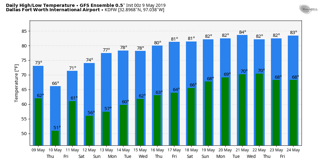 ON THIS DAY IN 2003: This was day two of a consecutive three day outbreak of strong to violent tornadoes in Oklahoma. A violent F4 tornado affected Moore, Oklahoma City, Midwest City, and Choctaw and took a very similar path to the May 3rd, 1999 tornado. Despite 130 injuries, no one died from this tornado.
A TYPICAL SPRING DAY: Temperatures in the mid to upper 60s in the morning, a mix of sun and clouds in the afternoon, temperatures in the low 80s with at least some chance of isolated showers and storms in the afternoon and evening hours - it must be spring in North Texas. Any storms we see will tend to be isolated in nature, and most spots will not see rain today. Some storms could be on the stronger side and may try to produce some hail and gusty winds in some spots. 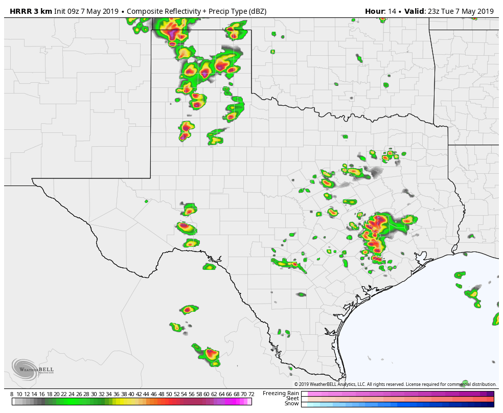 NOT AN ACTUAL FORECAST!!! While we enjoy just a few innocent rain showers in some spots, an active severe weather day is expected over parts of the Southern Plains down into West Texas. There is a "moderate risk" (4/5) of severe storms today for parts of the Texas Panhandle into extreme West Oklahoma. 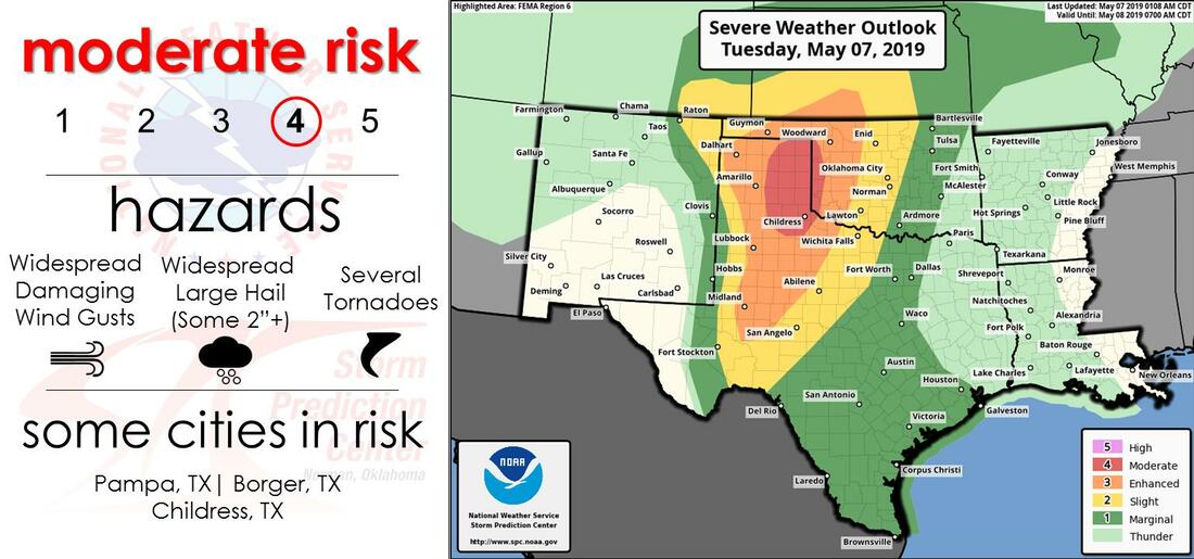 TOMORROW: There still lies many questions about tomorrow, and there are many factors to key into play. But for now, the Storm Prediction Center has areas to the east and south of the greater DFW Metroplex under the "enhanced risk" of severe storms (3/5) tomorrow, while DFW and surrounding areas retain the standard "slight risk" of severe storms (2/5). 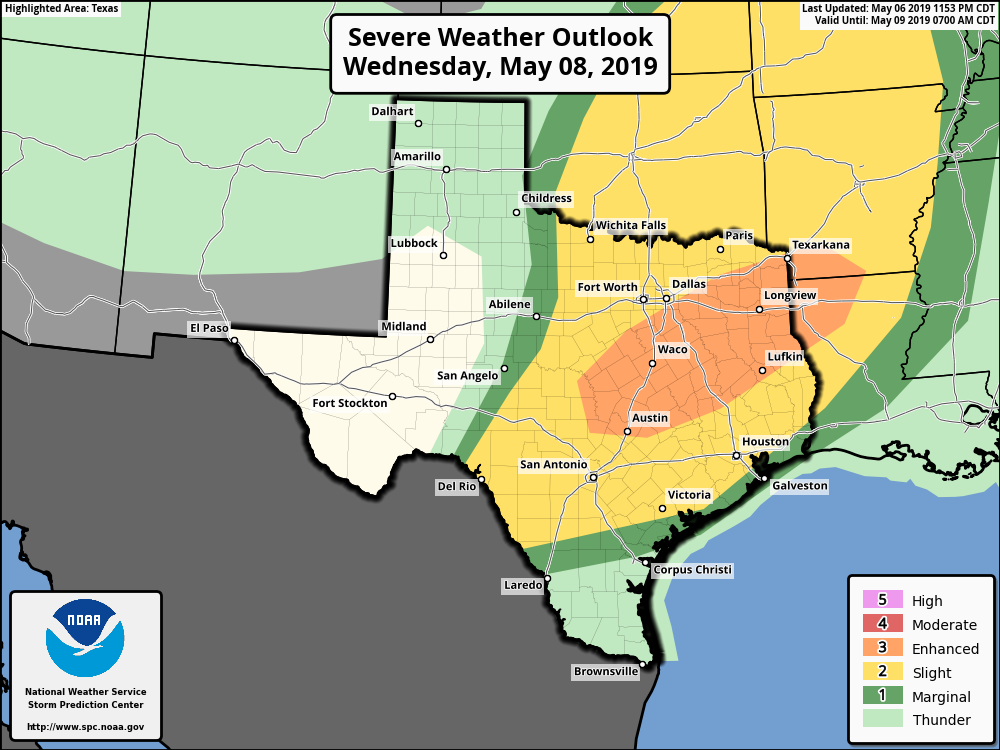 MORNING ROUND OF SEVERE WEDNESDAY: Using what Logan talked about in yesterday's blog, we should know that there are many scenarios that may go into tomorrow. Right now, our current thinking is that a line of strong to severe storms will roll through the North and Central Texas area during the morning rush hour and continue to move to the southeast with time. If this were to happen, the main thing we would have to deal with is strong, damaging wind gusts from the line in this morning, as the atmosphere would have already regained stability in the afternoon and evening, precluding any greater threat of severe storms in the evening. 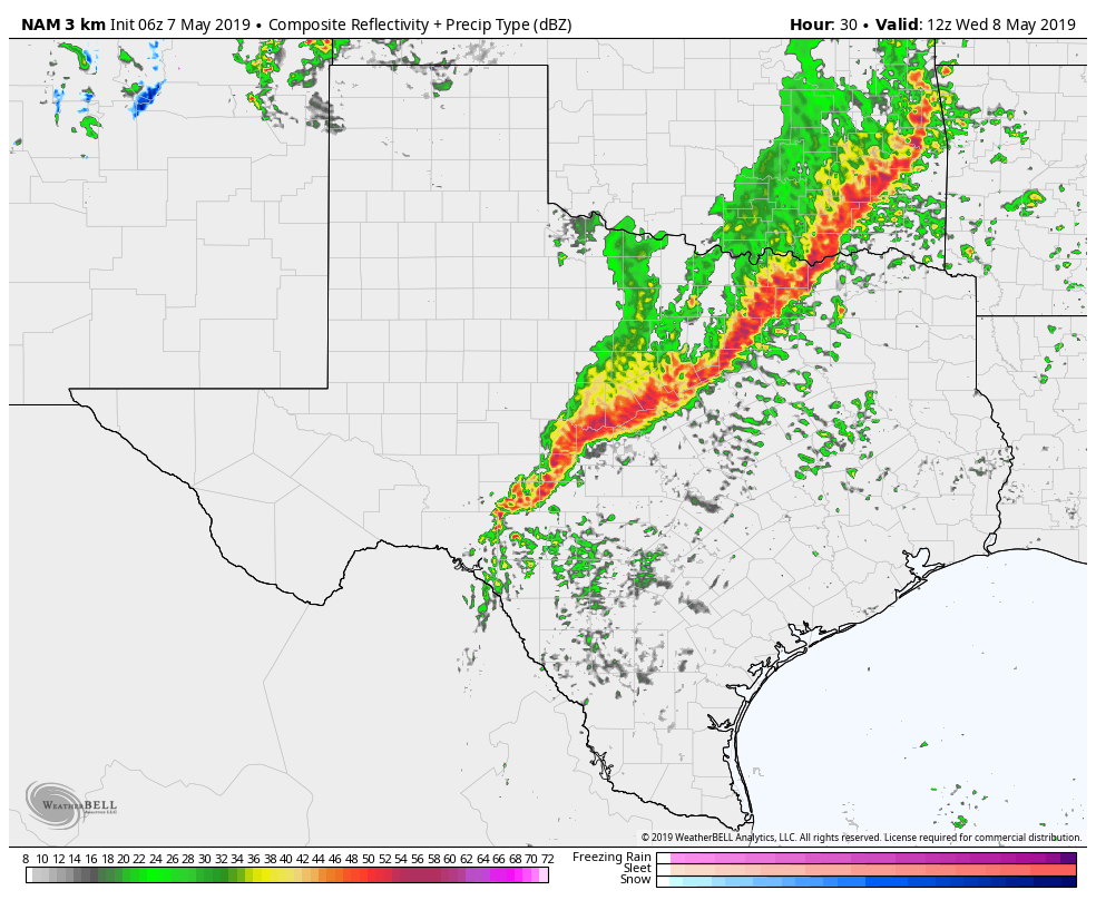 NOT AN ACTUAL FORECAST!!! However, keep in mind that there is the chance that a) the line of storms stay to the north in Oklahoma and doesn't affect North Texas or b) the line doesn't develop at all. If any of those scenarios happen, North Texas would be at a higher risk of severe storms in the afternoon and evening, which would ultimately be more of a hail and tornado risk at that point. As you can see, this is a very low confidence forecast with so many "if" factors coming into fruition. But one thing we can be certain of is North Texas seeing some type of severe weather tomorrow; we just don't know when. Therefore, it is imperative that you stick to the latest forecasts and make sure you have emergency alerts enabled on your phone. Moreover, every home and business should have a NOAA Weather Radio. THURSDAY: After the severe weather has passed, expect a mixture of sun and clouds throughout the day with highs in the low 80s, very seasonal for May in North Texas. FRIDAY AND THE WEEKEND: The cold front bringing severe storms to the southern plains will stall out around here for Friday and Saturday, so we will need to keep the chance of showers and storms in the forecast on Friday and Saturday. No severe weather threat on any of those days, and it will not rain all day. The high will be in the 70-75 degree range for the weekend. Sunday will feature a mix of sun and clouds. NEXT WEEK: The early part of next week looks a little wet with isolated showers possible on Monday and Tuesday. Otherwise, expect very seasonal conditions throughout the week. See the Texas Weather Discussion Video for more details.  Me and Logan are busy preparing graphics and setups to provide you with the most accurate and visually pleasing forecasts in the Dallas/Fort Worth Metroplex! Be sure to stay tuned for later updates!
I will have my next blog post (weather permitting) tomorrow morning at 7AM! Enjoy the day! Donovan Neal It is May in North Texas... it's the time of year we see an uptick in severe weather, and that is exactly what will happen as we move forward to Tuesday and Wednesday this week, especially Wednesday. There are 4 possible scenarios that could occur during the day Wednesday, let's dig in a bit more and discuss these details/scenarios. SCENARIO #1 - A complex of showers and storms, some severe, tracks across Oklahoma early Wednesday morning. While Oklahoma would have a fairly stable atmosphere, supercellular development would take place across North Texas. All modes of severe weather would be possible. SCENARIO #2 - A complex of showers and storms, some severe, tracks across north Texas and parts of Oklahoma early Wednesday morning, with damaging winds being the main threat, along with isolated tornado and small hail. A few storms would continue into the midday hour, before shifting east of our area. the atmosphere would remain stable, and the severe threat Wednesday afternoon would be much lower. SCENARIO #3 - Showers and storms track across North Texas & Oklahoma Wednesday morning, some severe. However, the rain moves out quickly and we see sunshine and sufficient destabilization Wednesday afternoon, and scattered supercells develop across North Texas and Oklahoma. All modes of severe weather will be possible. SCENARIO #4 - The severe storms that develop in West Texas Tuesday evening fall apart before reaching North Texas and Oklahoma, and we stay dry Tuesday night and Wednesday morning. Supercells develop Wednesday afternoon, and all modes of severe weather will be possible. As stated above, there are several different scenarios that could evolve Wednesday. This makes the forecast very complex and sensitive to any minor changes. The NWS/SPC has issued an ENHANCED RISK of severe weather for much of North Texas and Oklahoma, including the entire Dallas/fort Worth Metroplex. 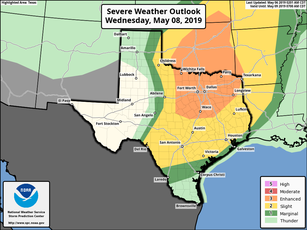 Stay with ApexStorm the next several days as we continue to refine the forecast.
Logan S. Forecaster for ApexStorm PREVIEW OF SUMMER: Temperatures are currently holding in the low to mid 70s across the great region of North Texas this morning; we expect sunny weather across north texas with highs in the 83-86° range this afternoon. Winds will be breezy, and humidity values will be very average.
TOMORROW: The weather for most of the day will still be very dry; will still continue to feature a mix of sun and clouds throughout the day. With moisture advection from the Gulf, we will mention the chance of a few isolated storms during the evening, but most places will not see rain. With the approach of a cold front, we cool down a few degrees with highs in the low 80s. WARM MORNING: Temperatures have not fallen much from yesterday, and are still mostly holding in the low to mid 70s this morning. There's a good chance we stay cloudy for the majority of the day, and we will only warm 10 to 15 degrees this afternoon as a result. ANOTHER ROUND OF SEVERE STORMS POSSIBLE THIS AFTERNOON: After dealing with some severe weather in North Texas yesterday evening that produced a couple brief tornadoes in Tarrant/Denton counties, we are expecting round #2 of severe weather this week to kick off the month of our peak severe weather season here in the Plains. The Storm Prediction Center has added an "enhanced risk" (level 3/5) of severe storms from Big Spring in West Texas to areas in and surrounding the DFW metroplex. The standard "slight risk" surrounds the areas outside of the metroplex such as Canton, Waco, Tyler, Texarkana, etc. 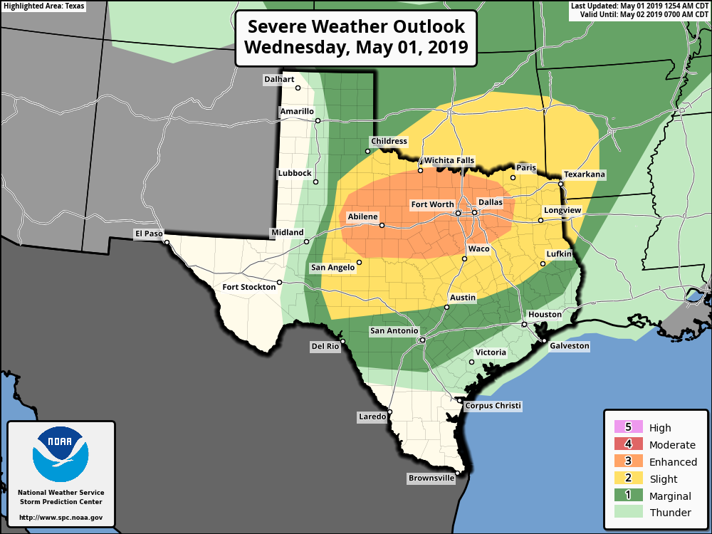 TIMING: Severe thunderstorms will develop in the late afternoon after 2PM in West and East Texas. They will encroach towards the metroplex over time, before impacting us during the evening and overnight hours. I expect the main action for our area at around 4-7PM. THREATS: These storms will have the capability of producing not only damaging winds, but large hail as well. The hail threat is just as equal as the damaging wind threat, considering how North Texas is notorious for seeing some of the most significant hail events. Just like yesterday, we could see a couple of brief tornadoes in the mix as well. RAIN: Another threat this afternoon and evening for everyone is heavy rain. Downpours are likely for those that experience severe thunderstorms this evening. Rainfall amounts of 2-3 inches are possible with isolated 4" likely. Flooding will become a concern for areas that not only see multiple storms, but for areas that received heavy rain yesterday. To address this, the NWS has issued a Flash Flood Watch for the Greater DFW Metroplex and areas to the North.  We are basically in the peak of severe weather season, and these type of threats are very common. However, it is imperative that you know where to go when threatened by severe weather. Some great severe weather safety tips can be found here. Also, you must ensure that your devices are charged, and you have a way of receiving warnings. That can also be found in the direct link above. Most of the severe weather could come during rush hour, so getting home a bit early won't hurt today. But most importantly, DO NOT PARK UNDER HIGHWAY OVERPASSES. THEY OFFER NO PROTECTION FROM SEVERE WEATHER AND CAN PUT LIVES AT RISK BY BLOCKING ANY ONCOMING TRAFFIC.
We will repeat this process again on Thursday, with another risk of severe weather for much of North and Central Texas this time. With lower wind shear values, we will have more of a large hail and damaging wind threat. Just like the past few days, we would like to get through today's severe weather threat before we focus on tomorrow's. |
Archives
April 2024
Categories |
 RSS Feed