
|
THIS MORNING - Temperatures are in the mid 60s across the region this morning, very mild for the last day of October. A few closely scattered showers and thunderstorms are about across the metroplex as well. Temperatures will go the wrong way with the cold front coming through, falling to the low 60s by the evening. STORMY AFTERNOON/EVENING AHEAD - A potent weather system will bring the threat of severe storms across Southern Texas this evening. Higher instability values will be located over southeastern Texas through central Louisiana, but higher helicity values are located near the northeastern tip of Texas. The best combination of all severe weather parameters will be located in southeastern Texas. The SPC has defined the "enhanced risk" (level 3/5) of severe storms from areas to the east of Austin to the west of Jackson, Mississippi. There is the standard "slight risk" (level 2/5) of severe storms defined from Ozona, Texas through Central Mississippi. And, there is a "marginal risk" (level 1/5) of severe storms defined for much of the DFW metroplex. 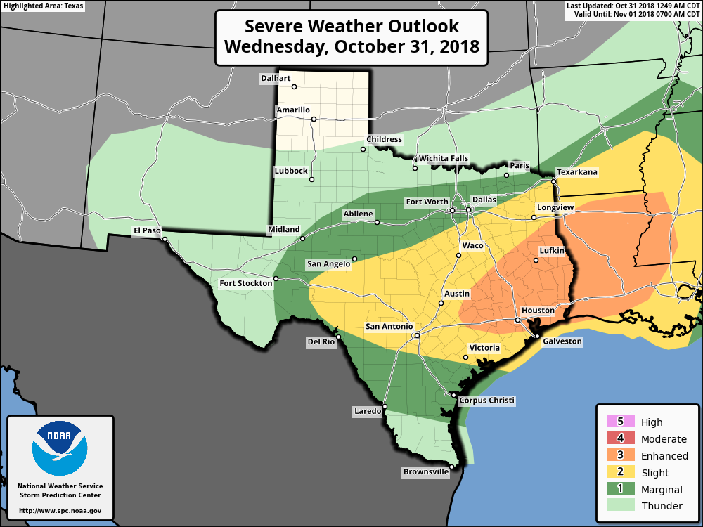 - The main window for heavy rain for North Texas will be from 7AM through 9PM this evening. - A few cells producing gusty winds and small hail can't be ruled out during the afternoon evening hours, especially for our southern counties. - Rain throughout the day will be heavy at times, with amounts of 1-3 inches likely to close out the wettest October on record. Be sure to follow ApexStorm on Twitter for forecast updates as activity begins to increase. Thursday (November 1) represents the beginning of late severe weather season here (November and December). FRIDAY AND THE WEEKEND - Clouds will linger throughout the day on Friday, but it will be another comfortable day with highs in the lower 70s. Then, the weekend will feature sunny skies Saturday and Sunday. We will stay in the lower 70s throughout the weekend. Morning lows will be in the mid 50s each day. NEXT WEEK - Most of next week looks mostly sunny and dry with highs in the 60s... See the Texas Weather Discussion Video for more details. 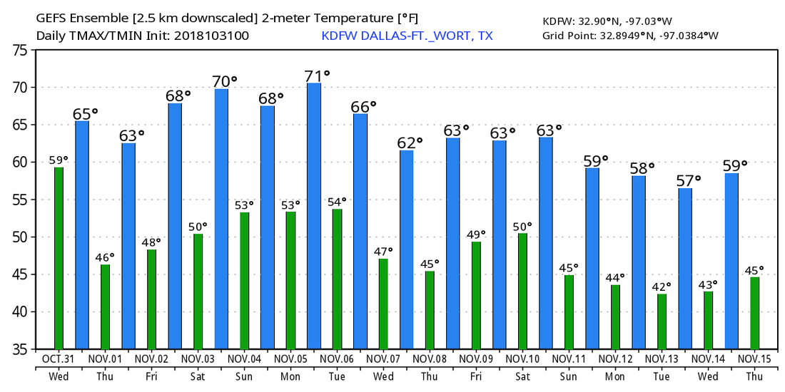 TROPICS - Hurricane Oscar is in the Central Atlantic, packing sustained winds of 75 mph. It will continue its journey to the northeast, away from land. The rest of the Atlantic Basin is quiet.
CLEAR MORNING - Nothing but dry weather and clear skies across our great state of Texas this morning; temperatures are mostly in the mid to upper 60s. Today will be dry and warm with increasing clouds by the afternoon. Highs will be in the upper 70s for most communities today. HALLOWEEN - We are forecasting a mostly wet, rainy, and cool Wednesday with widespread scattered showers and thunderstorms across the region throughout the day as a cold front and a dynamic weather system moves into Texas from the west. The SPC has much of the area to the southeast of North Texas in risks of severe thunderstorms on Wednesday, and we in North Texas will certainly have the potential for a couple of those. 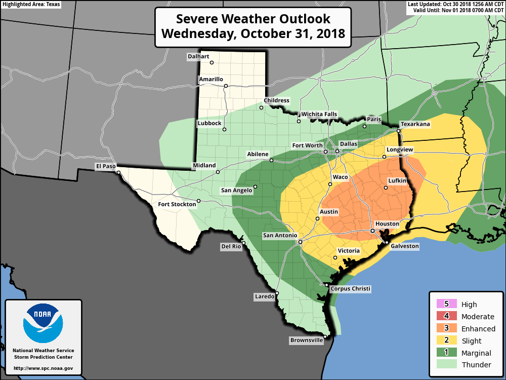 - It looks like the best chance of severe weather tomorrow will come over the southern half of the state where instability values are much higher by the afternoon and evening. - Storms over Southern Texas will have the potential of producing damaging winds and large hail. A brief tornado or two can never be ruled out, based on shearing profiles. - The main window for the most widespread rain will come from 10:00 a.m. - 10:00 p.m.. - Rain amounts will range anywhere from an inch to two and a half inches across North Texas. Of course, the forecast will be fine tuned more throughout the day as confidence increases. FRIDAY AND THE WEEKEND - The sky will be mostly sunny on Friday as drier air rolls into the state. Friday will be in the upper 60s. Then, we expect a pleasant weekend ahead full of sunshine Saturday and Sunday. Highs will be in the 70s with lows in the mid 50s. NEXT WEEK - Most of next week looks pleasant and dry with average temperatures... See the Texas Weather Discussion Video for more details. 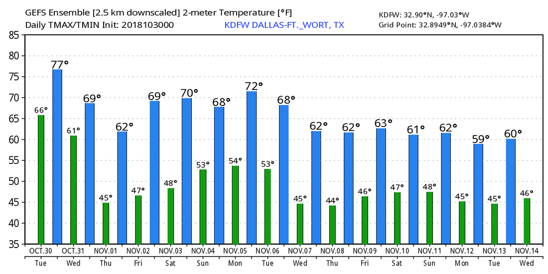 TROPICS - Hurricane Oscar is still in the Central Atlantic as a category two with max sustained winds of 105. It will move to the north, northeast, away from land in coming days. The rest of the Atlantic Basin is quiet. 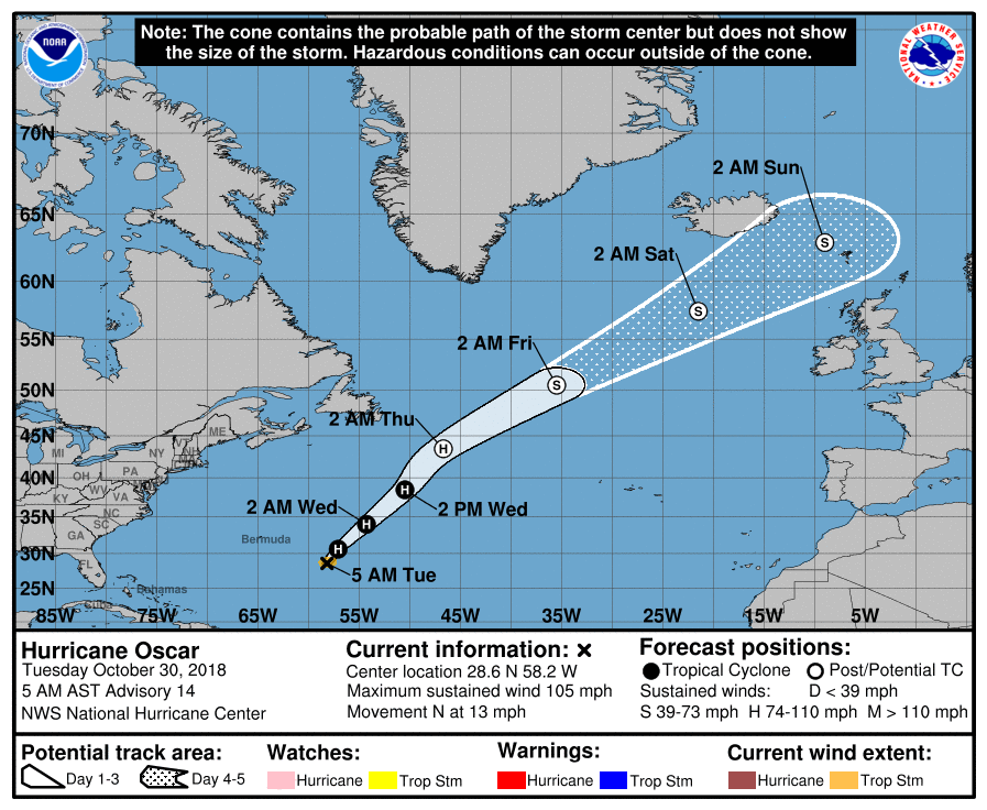 FAIRLY COOL START - Temperatures are currently in the mid to upper 50s across the North Texas area... We will warm to the low 80s today with sunshine in full force, which is above our average high of 74° for late October. Not much change in the forecast for tomorrow either; mostly sunny, very warm afternoon with highs near 80°. HALLOWEEN - A cold front will move through during the early morning hours on Wednesday, which means cooler temperatures and a good chance of scattered/numerous showers and thunderstorms throughout the day. The good news is rain may begin to dissipate before 7P, which is the perfect time for trick-or-treating though the streets will likely be quite wet. Highs will be in the upper 60s Wednesday with mostly cloudy skies. REST OF THE WEEK THROUGH THE WEEKEND - A high pressure builds over West Texas on Thursday, and we subsequently stay dry for the rest of the work week with mostly sunny skies. Highs will be in the mid 60s for Thursday and Friday, closer to 70° on Friday, absolutely perfect weather for high school football games. The weekend will be no exception to more sunshine and nice, fall weather. Highs will be in the upper 60s both days with mostly sunny skies. Clouds may increase on Sunday. NEXT WEEK - The beginning of the first full week of November looks dry with abundant sunshine. Highs will stay in the upper 60s to low 70s. See the Texas Weather Discussion Video for more details. 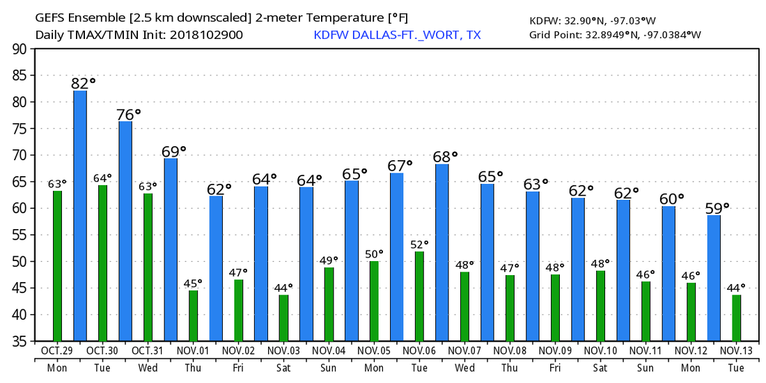 TROPICS - Hurricane Oscar is in the Central Atlantic with maximum sustained winds of 80 mph. It may try to intensify to a Category Two hurricane before it becomes post-tropical in the Northern Atlantic Thursday morning. No threat to any land areas. The rest of the Atlantic Basin remains very quiet. The 2018 Atlantic Hurricane Season officially ends November 31. 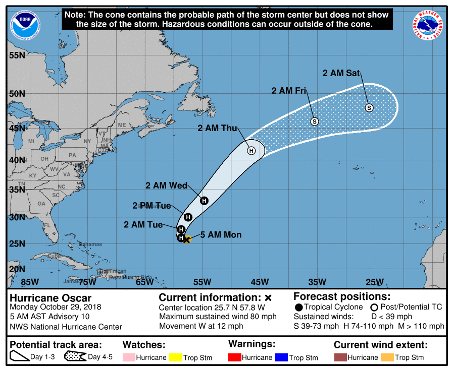 THIS MORNING - We have a chilly morning in place with temperatures in the mid 50s with light fog and light drizzle in some places. Clouds will linger for most of the region tonight in response to a surface low over southern Texas. Highs will be in the low to mid 60s today. FRIDAY AND THE WEEKEND - We will stay rain free for the next three days with highs mostly in the 70 degree range. The sky remains mostly sunny during the weekend, and morning lows will be in the low 50s for most spots. NEXT WEEK - The first half of next week will be dry with sunny, pleasant days with cool, clear nights. Some rain is likely along a cold front towards the Halloween and the start of November. See the Texas Weather Discussion Video for more details. 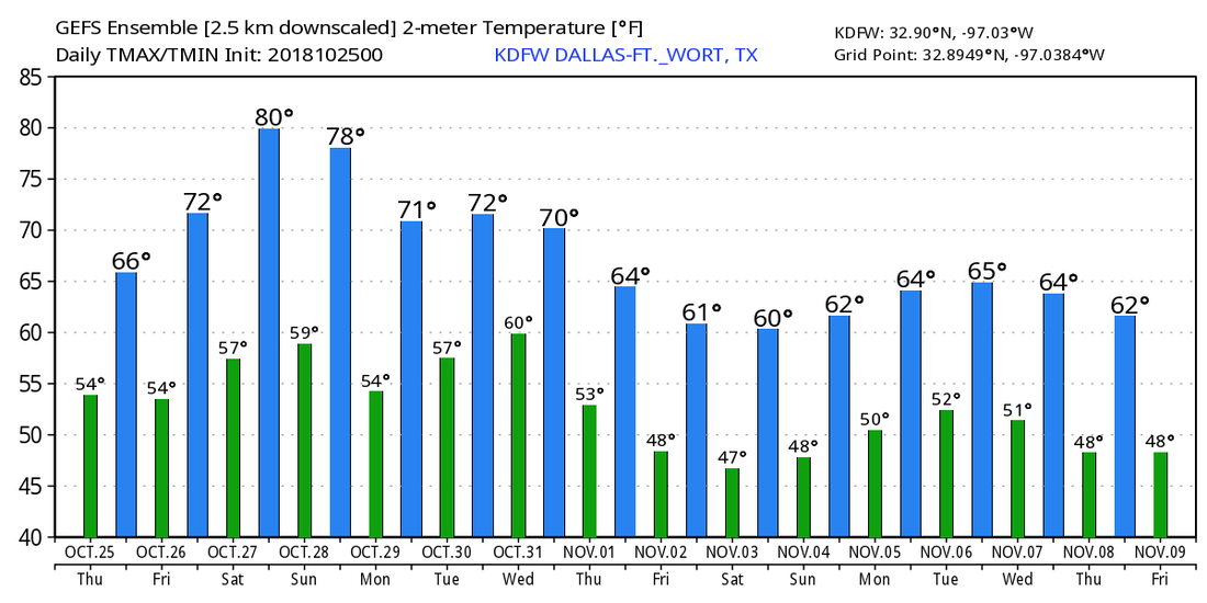 TROPICS - A disturbance in the Central Atlantic could develop into a tropical depression in the next few days, but it will most likely remain very far from land. The rest of the Atlantic Basin remains quiet.
FAIR MORNING - Temperatures are currently in the mid 50s with a mostly cloudy sky. We won't warm much today as rain-cooled air keeps us below 60°. Tropical Depression Willa in Central Mexico will dissipate into an open wave later today, but its wave energy will spin a low in the Gulf and move to the northwest which will cause widespread rain chances for most of the state this afternoon. The main window of the highest probability of rain will be from 11:00AM-12:00AM. Some rain may persist into early Thursday morning in some spots. Rain amounts will be in the 1"-1 1/2" range for most communities in North and Central Texas today. Since we are in a cool, stable airmass, lightning and thunder will not be of concern today, just periods of heavy rain at times. The rainmass will move to the east early Thursday morning, and afternoon highs will be in the mid 60s on Thursday partly to mostly cloudy skies. FRIDAY AND THE WEEKEND - We revert back to a nice, stable fall weather pattern with mostly sunny skies and highs in the low to mid 70s with morning lows in the upper 40s to low 50s. No rain is expected through the weekend. NEXT WEEK - Next week becomes questionable in terms of rain chances. Recent guidance shows at least some chance of showers and storms by Halloween with a cold front moving to the east. But then Friday might be a wet day with lingering moisture. Too early to tell at this point, so we will leave a mostly dry forecast next week with afternoon highs mostly in the low to mid 70s. See the Texas Weather Discussion Video for more details. 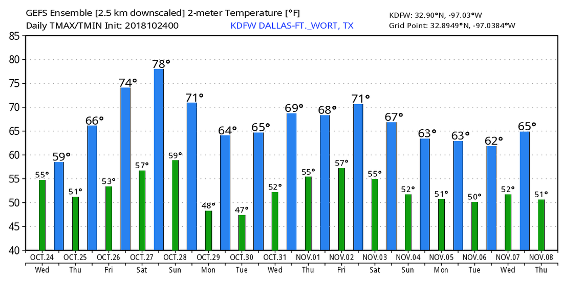 TROPICS - There is a broad low in the central Atlantic that the NHC gives a 50/50 chance of developing into a tropical depression or storm this weekend... It will gain a little bit of latitude before turning to the west. It is way too early to pinpoint whether or not this will have an impact on the US East Coast. The rest of the Atlantic Basin is quiet. 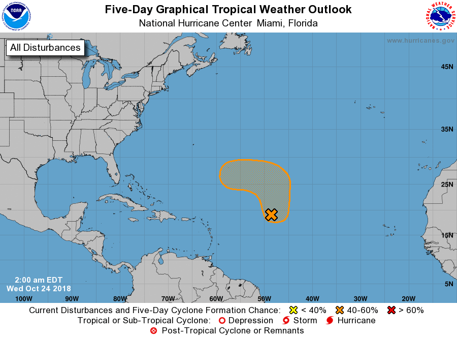 FALL-LIKE WEATHER CONTINUES - For most of North Texas, dry weather continues today; the sky will feature a mix of sun and clouds with a high in the low 70s. Clouds will thicken during the overnight hours. WEDNESDAY/THURSDAY - High wave energy from Hurricane Willa in the eastern Pacific will spin up a surface low in the Gulf tonight. The feature will move northward, and will bring the chance of widespread rain statewide. The best window for widespread rain is Wednesday afternoon/early Thursday morning. The rain will end from west to east Thursday afternoon as the low moves eastward. Temperatures will hold in the 50s for most spots on Wednesday, well below our average high for late October. Rain amounts of 1/2 - 1 inch will be possible for most areas in North Texas, with over an inch possible for the central part of the state. FRIDAY AND THE WEEKEND - Friday looks dry with a mixture of sun and clouds with highs in the low 70s. Sunshine will be in full force Saturday and Sunday with highs in the mid 70s and upper 60s with morning lows in the upper 40s to low 50s. NEXT WEEK - Monday and Tuesday look mostly dry with a mix of sun and clouds... Some rain returns with mostly cloudy skies during Halloween and the first of November with an approaching front. See the Texas Weather Discussion Video for more details. 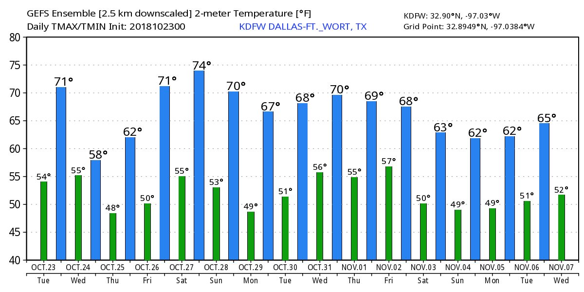 TROPICS - The Atlantic Basin continues to remain very quiet. However, in the eastern Pacific, Hurricane Will will landfall on the Mexican coast as a Category three hurricane later today. It will dissipate in Northern Mexico tomorrow afternoon, but moisture from the system will move into Texas. 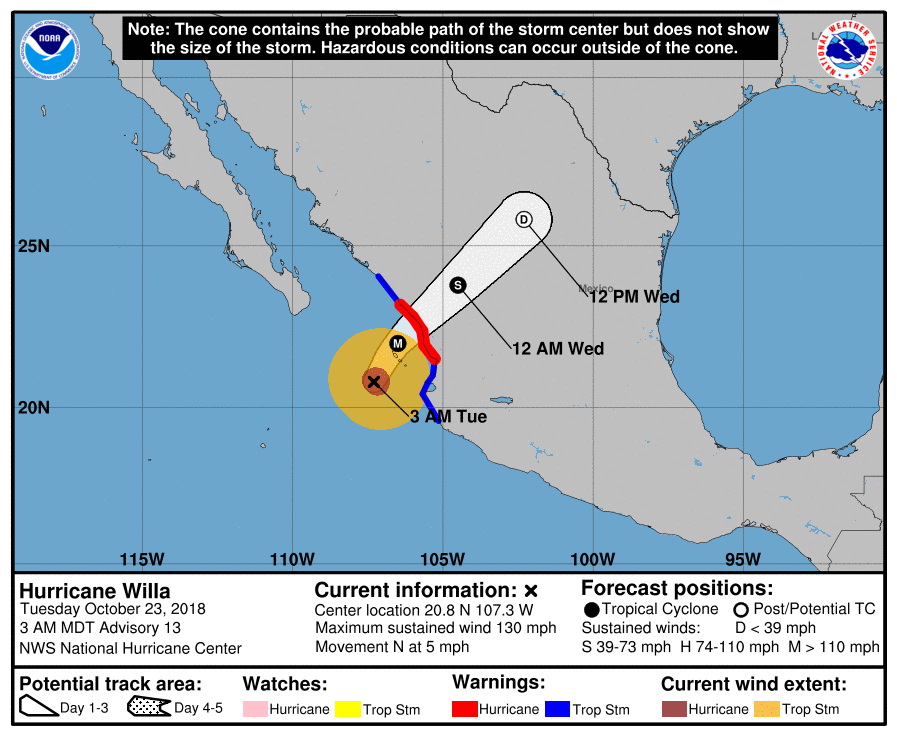 DRY MORNING - Temperatures are mostly in the upper 40s to low 50s this morning with a mostly clear sky. We will continue with a mostly dry day with a mix of sun and clouds as we enter a zonal flow here. Highs will be in the low to mid 60s today and tomorrow. MIDWEEK - Moisture from the remnants of Wilma in the Gulf will continue to slowly move eastward, bring widespread showers and thunderstorms to the state on Wednesday. Everyone will have a fair game in some rain at times, and temperatures will be in the mid to upper 50s with a mostly cloudy sky. Some morning leftover rain will be possible Thursday morning, clearing out by the afternoon to a mix of sun and clouds. Thursday and Friday look mostly dry with highs in the low to mid 60s. THE WEEKEND - Not much change. With an upper high in Central Texas, we will continue to mention sunny, fall-like weather with afternoon highs in the low 70s with morning lows in the mid 50s, that's still about 5 to 7 degrees below our average high of 77. NEXT WEEK - The early part of next week looks mostly dry and sunny with highs mostly in the mid 70s. As we transition into Wednesday, model guidance now shows a strong front carrying at least some chances of scattered showers and storms during the afternoon with highs in the low 60s. Other solutions showed 70 degrees as afternoon highs. The bottom line is - we don't know yet. It is still too far out to pinpoint any specific details regarding temperatures or precipitation chances for Halloween. See the Texas Weather Discussion Video for more details. 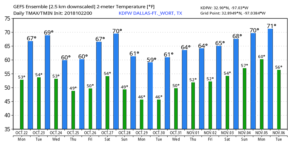 TROPICS - All is quiet in the Atlantic Basin, and no new tropical cyclones are expected to form for the next week. The 2018 Atlantic Hurricane Season ends on November 31.
RADAR CHECK - A few scattered showers and thunderstorms are about this morning in North Texas, mainly to the west of the North-Central Texas coverage area.  This will be another case of another round of numerous/widespread showers and thunderstorms later this afternoon and evening. As a result, we will not warm much this afternoon, and temperatures will most likely stay in the mid 50s for the rest of the day. FOOTBALL WEATHER - For the high school football games tonight, the game will be played under an overcast sky with showers and thunderstorms likely at any time. Temperatures will remain in the mid 50s throughout the game. THE WEEKEND - We will mention a chance of morning light rain, but it will not rain all day. Otherwise, expect Saturday to be another cool day with a mix of sun and clouds with temperatures in the upper 60s. The sky fully clears Saturday night, and sunshine finally returns in full force Sunday. Saturday and Sunday morning will be very cool with lows in the upper 40s. The high Sunday will be in the mid 60s, about 13 degrees below our average high of 78°. NEXT WEEK - Monday and Tuesday looks mostly dry with highs in the low 60s. A wave from the Gulf of Mexico moves into Texas which will cause a surge of moisture, enough to introduce the chance of scattered/numerous showers and thunderstorms on Wednesday. We start to clear out during the latter half of the week to a mix of sun and clouds on most afternoons. Highs will mostly be in the 60 degree range with morning lows in the 50s. See the Texas Weather Discussion Video for more details. 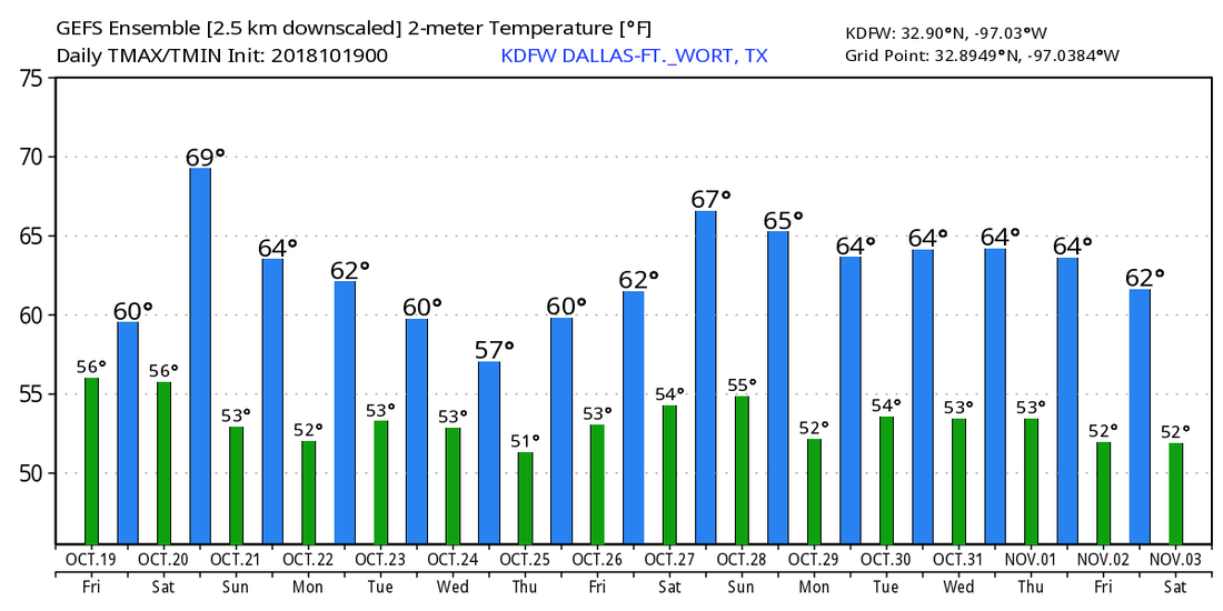 TROPICS - The Atlantic Basin continues to remain quiet, and tropical cyclone formation is not expected for at least the next week.
DRY MORNING - For the first time this week, we don't have widespread showers and thunderstorms across the entire region. This has allowed temperatures to rise to the low to mid 50s with mostly cloudy skies. However, rain will increase this afternoon and evening, but it will be more of a light rain rather than downpours. Highs will be in the low 60s otherwise. FRIDAY AND THE WEEKEND - Friday morning should be another dry morning with the morning low in the low 50s once again. However, widespread rain will be possible again during the afternoon and evening with highs near 60°. Rain continues through early Saturday morning, then tapers off during the afternoon. We should stay dry for most of the weekend with highs in the mid to upper 60s under mostly cloudy skies. Lows should be closer to 50°. FOOTBALL WEATHER - For the high school football games tomorrow, expect the games to be played under rain for most spots. Temperatures will start in the upper 50s at kickoff, falling into the low 50s by the final whistle. NEXT WEEK - Next week looks mostly dry with the exception of Wednesday, where a shortwave trough will move easterly, causing another round of widespread showers and thunderstorms mainly during the afternoon. Otherwise, expect cloudiness to linger early next week, with the sun coming out by the latter half of the week. See the Texas Weather Discussion Video for more details. 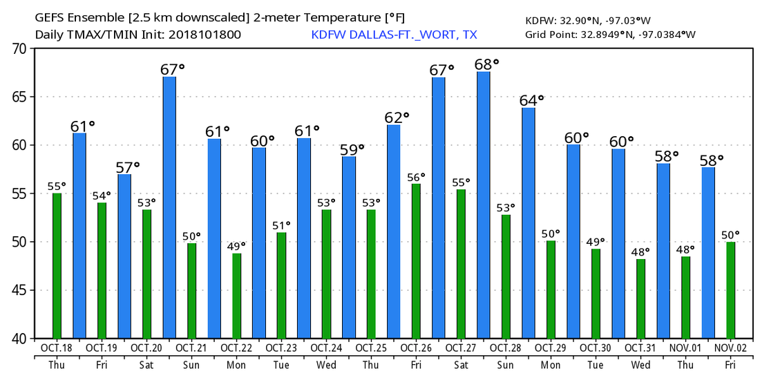 TROPICS - The Atlantic Basin remains very quiet, and tropical cyclone formation is not expected through the weekend.
*no Texas Weather Discussion Video this morning* RADAR CHECK - Once again, showers and thunderstorms are entering DFW from the southwest this morning...  The difference with today is that we should experience more breaks from the rain today, until it eventually tapers off during the afternoon and evening hours. Temperatures are currently in the middle 40s right now. The nice thing is that we should not stay in the low to mid 40s all day. We will likely see temperatures in the mid 50s by the afternoon hours with mostly cloudy skies. Rain may develop overnight and persist into Thursday morning before tapering off in the afternoon (eventually). The best chance of any one spot getting wet is in the 60/70 percent range on Thursday. Afternoon highs will be closer to 60 degrees for Thursday and Friday. Afternoon showers and thunderstorms will be possible Friday as the morning stays dry. THE WEEKEND - We may deal with a morning batch of rain, but the good news is that it won't be as persistent and widespread as in recent days. The chance of a spot getting wet on Saturday is only in the 30 percent range, so most communities will stay dry with highs in the middle to upper 60s. Sunday will feature mostly cloudy skies and a mainly dry forecast for the first time in ten days! Highs should be in the upper 60s again. NEXT WEEK - We start off next week dry with partly to mostly cloudy skies, then we introduce small chances of scattered showers and thunderstorms towards the latter half of the week. Right now, it looks like most communities stay dry during the week with highs closer to 65° and morning lows in the low 50s. 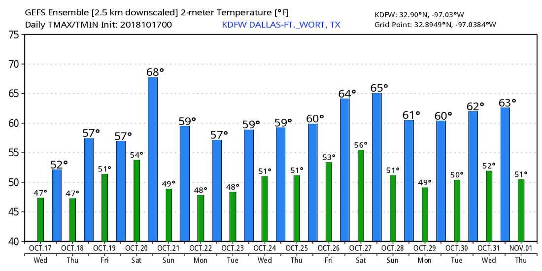 TROPICS - For the first time since August, the Atlantic Basin is quiet, and no new tropical cyclones are expected for the rest of this week through the weekend.
RADAR CHECK - Cold rain continues over much of the North/Central Texas area this morning.  Widespread rain will continue moving northeast over the course of the day. A Flash Flood Watch remains in effect until 7PM this evening, and additional rainfall amounts of 1-4 inches will be possible over North Texas over the remainder of this week. Temperatures are currently in the low to mid 40s now with the wind chill in the mid 30s. We will likely stay there as the rain does not go away anytime soon today. WEDNESDAY THROUGH FRIDAY - Rain will continue through the morning hours before decreasing in coverage during the afternoon and evening. We will be slightly warmer as temperatures will warm to the low to mid 50s during the afternoon on Wednesday. Confidence is increasing that a good chunk of Thursday morning will be dry with temperatures in the 50s, but more rain will move in during the afternoon hours and persist overnight through Friday. The good news is that the widespread coverage does not appear that likely at this present time, but is not out of the question. Temperatures will stay just at or below the 60 degree mark for Thursday and Friday. THE WEEKEND - An upper high builds in the Central Plains, pushing a new surge of drier air into the region. We will stay mostly cloudy though with highs in the low to mid 60s for Saturday and Sunday. Occasional showers and thunderstorms are not completely out of the question. NEXT WEEK - For now, the early part of next week looks dry with a mix of sun and clouds with highs in the mid 60s. A few showers could move in from the south during the latter half of the week, but a majority of the week looks partly to mostly cloudy and dry. See the Texas Weather Discussion Video for more details. 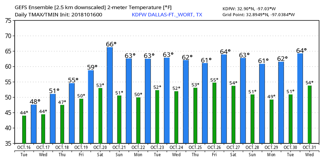 TROPICS - There is a disturbance near the Yucatan Penisula that will travel inland towards Central America. The rest of the Atlantic Basin and the Gulf of Mexico remains quiet.
RADAR CHECK - Widespread showers and thunderstorms continue to move to the northeast this morning, affecting most of the North Texas area...  There will indeed be breaks in the rain from time to time, but expect numerous showers and thunderstorms all throughout the day as moisture continues to move to the northeast. Heavy rain will continue to come in waves throughout the day, and a Flash Flood Watch remains in effect for much of North Texas until tomorrow morning. 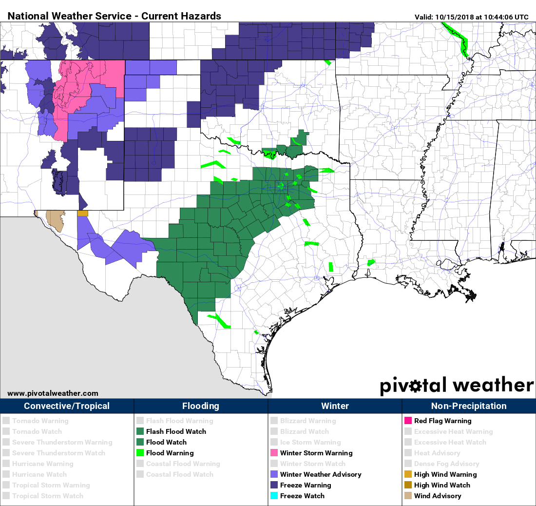 SWEATER WEATHER - Due to the cold front that came through overnight, we are currently seeing temperatures in the low 40s this morning, even as low as the upper 30s in some communities. DFW is tying its record low for the day of 42 degrees. We won't warm much today and tomorrow; we will only see temperatures as high as the mid 40s at best. The wind chill will feel like the middle to upper 30s in most spots, just at or above the freezing mark. WEDNESDAY THROUGH FRIDAY - Showers and thunderstorms begin to taper off during the morning hours on Wednesday, and we might see more breaks from the rain during the latter half of the week. But expect conditions to stay mostly wet throughout the work week with highs in the upper 50s/low 60s through Friday with mostly cloudy skies. THE WEEKEND - Rain finally begins to taper off Saturday afternoon as an upper high pushes a surge of drier air to the south. Expect a few scattered showers Saturday morning followed by dry conditions as we head into the afternoon and Sunday. We stay mostly cloudy with highs in the middle 60s throughout the weekend. NEXT WEEK - The early part of next week looks fairly dry to start off. Some rain could sneak into the latter half of the week, but we are still quite a ways away from that. Expect a mix of sun and clouds with highs in the middle 60s throughout the week. See the Texas Weather Discussion Video for more details. 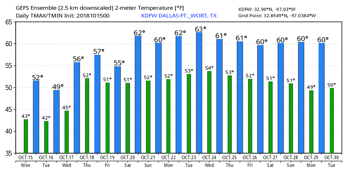 TROPICS - There is a small wave in the northern Caribbean that the NHC gives a 30 percent chance of becoming a tropical cyclone. It is expected to move onto land and weaken within the coming days. The rest of the Atlantic Basin remains quiet.
COOL AIR - We are starting the day with temperatures down in the upper 50s/low 60s for most communities in North Texas. Today will feature mostly cloudy skies with scattered showers and thunderstorm chances all day. The best chance of a spot getting wet is in the 40/50 percent range at this time. Many places will struggle to reach 70 degrees today, but overnight lows will be in the low 60s again. THE WEEKEND - Our weather for the weekend will be dependent on how Tropical Storm Sergio behaves once it reaches North Texas. Right now, Sergio looks like it will brings tons of moisture to North and Central Texas on Saturday, which will mean widespread scattered showers and thunderstorms is starting to look more likely for the weekend, mainly on Saturday. Most communities will get wet during the weekend, and rain amounts will be in the 3-4 inch range for most of North Texas, which also raises the concern for flash flooding, especially on Saturday. The remnant low dissipates on Sunday, but we could still tap on some moisture for a few scattered showers. The best chance of a spot getting wet is 30 percent on Sunday. Highs will stay in the middle 60s for both days. NEXT WEEK - Another disturbance moves down from the north early Monday morning, bringing more chances of widespread showers and thunderstorms and maybe even the potential for winter precipitation for the Texas Panhandle. Monday looks like a cold, raw, muggy day with highs only reaching the low 50s, though global models only show most of North Texas in the middle to upper 40s by the afternoon. The rain lingers through Tuesday, which will be another raw, muggy day with highs only in the low to mid 50s by the afternoon. Flooding could be a concern again as an additional 2-3 inches of rainfall is expected through Wednesday morning. We trend dry for the latter half of the week as we warm to the middle to upper 60s with partly to mostly sunny skies. See the Texas Weather Discussion Video for more details. 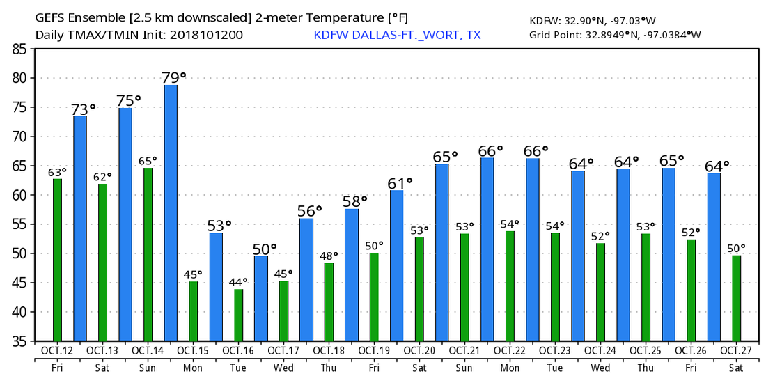 TROPICS - Michael is now a post-tropical cyclone, moving away from the US. Hurricane Leslie and Tropical Storm Nadine are in the eastern Atlantic posing no threat to land. A disturbance in the Caribbean will move into Central America in coming days. The NHC only gives it a 20 percent chance of developing over the next five days. 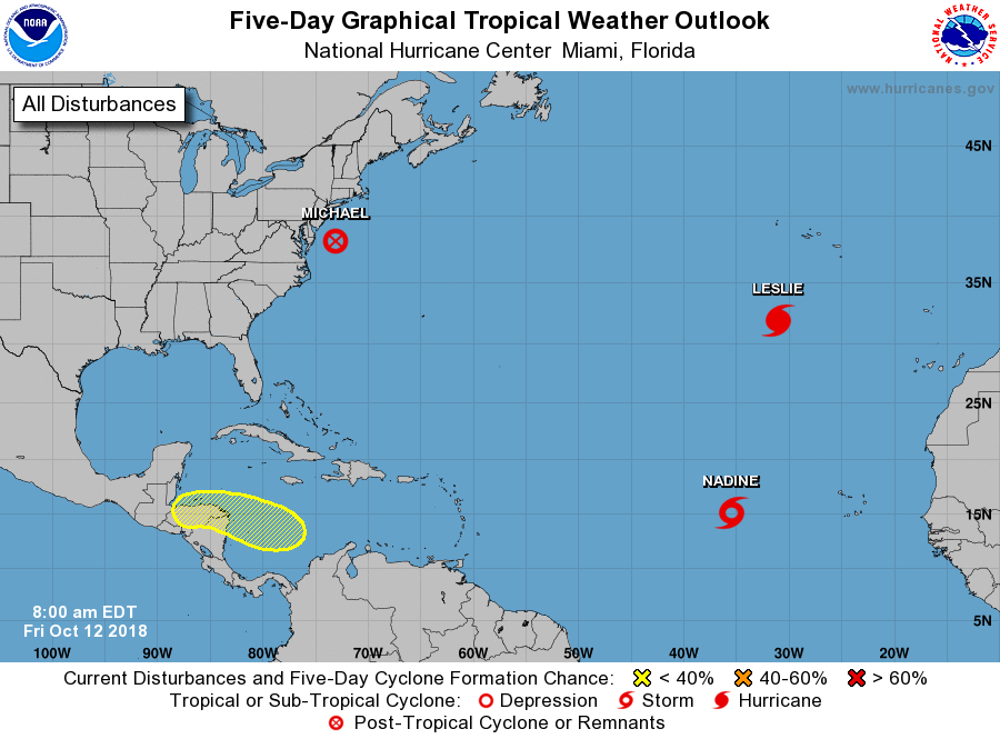 CHILLY START - Temperatures are in the middle 50s to start the day off... Probably the coolest we have been since April. We project a high closer to 70 degrees today with mostly sunny skies. We have been getting a real feel of fall for the past few days and it is only expected to continue. FRIDAY AND THE WEEKEND - A little bit of moisture starts to move to the east by Friday, and we will mention a few scattered showers during the afternoon and evening. The best chance of a spot getting wet is in the 20/30 percent range, and highs will be closer to 70 degrees again with partly to mostly sunny skies. The remnant low of Tropical Storm Sergio in the Eastern Pacific will move inland to the northeast towards North Texas on Saturday. The best chance of rain this weekend will lie during the afternoon/overnight hours on Saturday as the low moves to the northeast. A cold front comes through late Sunday morning, which will promote cooler temperatures for the rest of the day. We will mention partly to mostly cloudy skies with highs hovering in the low 70s/upper 60s. NEXT WEEK AND BEYOND - Moisture begins to plume over Texas, which signals even more chances of scattered showers and thunderstorms. The chance of one spot getting wet is around 50/50 for Monday at that point. Highs will be in the mid 50s and morning lows in the mid 40s, about 25-30 degrees below our average high of 80.  We will continue to have cool, crisp air for the rest of the week with afternoon highs in the 60-70 degree range with morning lows in the low to mid 50s. And the CPC (Climate Prediction Center) suggests that we will have below average temperatures for the next 6-10 days. With strong cold front that will come through Sunday morning, we will experience multiple chilly mornings and cool, crisp afternoons for a while, a true feel of what fall is like. See the Texas Weather Discussion Video for more details.  TROPICS - In the Atlantic Basin, we have a total of three named storms.
Tropical Storm Nadine will dissipate this weekend with no threat to land. Hurricane Leslie will weaken and become post-tropical by this weekend with no threat to land. Tropical Storm Michael is moving through the Carolinas at this time. It will continue to move to the northeast and become post-tropical once it hits the water again. From there, Michael will continue its journey to the northeast with no threat to land. And, there is another wave in the Caribbean Sea that has a 50/50 chance of becoming a tropical depression in the next five to seven days. This will impact Mexico with no threat to the U.S. MICHAEL NOW A CATEGORY FOUR HURRICANE - Overnight, Michael strengthened into an extremely dangerous, life-threatening category four hurricane in the Gulf of Mexico now with sustained winds of 140 mph. This will make landfall near Panama City Beach today. 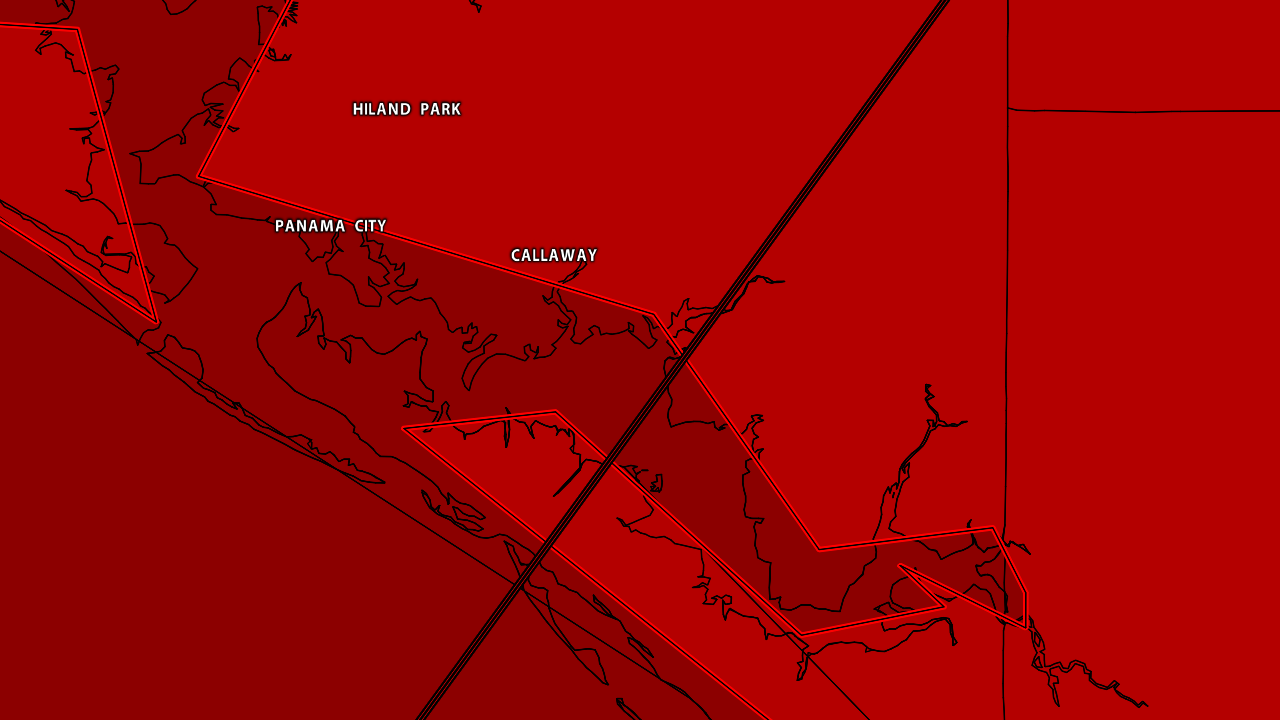 A HURRICANE WARNING IS IN EFFECT FOR...
* ALABAMA/FLORIDA BORDER TO SUWANNEE RIVER FLORIDA A TROPICAL STORM WARNING IS IN EFFECT FOR... * ALABAMA/FLORIDA BORDER TO THE MISSISSIPPI/ALABAMA BORDER * SUWANEE RIVER FLORIDA TO CHASSAHOWITZKA FLORIDA * NORTH OF FERNANDINA BEACH FLORIDA TO SURF CITY NORTH CAROLINA A STORM SURGE WARNING IS IN EFFECT FOR... * OKALOOSA/WALTON COUNTY LINE FLORIDA TO ANCLOTE RIVER FLORIDA. DANGEROUS STORM SURGE AND TIDE WILL CAUSE TYPICALLY DRY AREAS TO BE FLOODED BY THE OCEAN WATERS. THE WATER WILL HAVE THE POTENTIAL TO REACH THE FOLLOW HEIGHTS ABOVE GROUND AT PEAK SURGE DURING THE HIGH TIDE... TYNDALL AFL TO KEATON BEACH - 9-13FT OKALOOSA/WALTON COUNTY LINE TO TYNALL AFB - 6-9FT KEATON BEACH TO CEDAR KEY - 6-9FT CEDAR KEY TO CHASSAHOWITZKA - 4-6FT CHASSAHOWITZKA TO ANNA MARIA ISLAND - 2-4FT Rain amounts of up to five to six inches are possible across the Florida Panhandle through southern Georgia and Northern North Carolina. This is a progressive system that will not stall like Florence. A few tornadoes are possible today across North Florida and southern Georgia and areas on the right side of the center of Michael. Sunshine will return to the Gulf Coast tomorrow, which should be perfect for the National Shrimp Festival in Gulf Shores this weekend with sunny, pleasant days and fair nights. REST OF THE WEEK FOR NORTH TEXAS - An upper high is located over the Texas Panhandle, which means we will experience cool, crisp days for a long time. Highs will be in the mid 70s and morning lows will be in the mid 50s with mostly sunny skies. THE WEEKEND - The remnants of Sergio in the pacific will be moving to the northeast towards North Texas, and we should be able to pick up a bit of moisture from the system. We will mention the chance of scattered showers and thunderstorms Saturday evening through early Sunday morning. A good chunk of both days will be mostly dry with highs in the mid 70s on Saturday, falling into the middle 60s on Sunday as the cold front moves through. NEXT WEEK - We truly welcome in fall weather for the next several days with cool, crisp afternoons and fair, cold nights. Lows will be mid 40s to mid 50s, and the sky will be partly to mostly cloudy with highs in low to mid 60s for most of the week. See the Texas Weather Discussion Video for more details. VERY STRONG SUBSIDENCE - A strong upper meter high is located over the Deep South, and the sinking air is subsequently precluding any showers or thunderstorms from forming in North Texas. We will continue to be mostly sunny today with highs in the upper 80s/lower 90s, 7-10 degrees above average for early October in North Texas. THE WEEKEND - A cold front moves south during the weekend, but doesn't quite make it to North Texas on Saturday. We will still mention the chance of a few scattered showers and thunderstorms during the afternoon though. Odds of one spot getting wet are in the 30 percent bracket. Moisture increases Sunday, and we will subsequently mention the chance for scattered showers and thunderstorms during the afternoon, which brings the chances of a spot getting wet to the 50/50 percent range. Highs will be in the middle 80s with partly to mostly sunny skies. NEXT WEEK AND BEYOND - Showers and thunderstorms will continue through the early part of next week, with Tuesday having the best chance of one getting wet as the storm system pushes off to the east. Storms will taper off Wednesday morning, and we should be dry for the rest of the week. Highs will stay close to 80 degrees for most of the workweek with partly to mostly cloudy skies. Global models continue to indicate a possible pattern chance which much cooler temperatures by the middle of the month. See the Texas Weather Discussion Video for more details.  TROPICS - Tropical Storm Leslie is in the middle of the Atlantic, it will continue to remain to far from land. The NHC now gives the disturbance near the Yucatan Peninsula a 60 percent chance of developing within the next five days as it continues its journey northward towards the Gulf of Mexico. 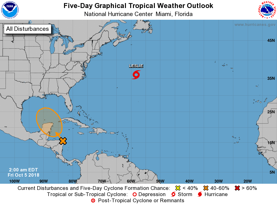 FEELS LIKE SUMMER - A very persistent upper meter high will remain parked over the central and eastern third of the country for at least the next two to three days. This means temperatures here in North Texas will remain generally above average. While we are experiencing late-summer time heat in October, parts of North Dakota are experiencing their first snow of the season. This was taken from one of North Dakota's NDDOT cameras yesterday morning. 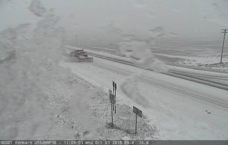 We are projecting mostly sunny skies and very warm days with fair nights today and tomorrow. Afternoon highs will be close to 90 degrees with lows in the 68-74 degree range. The chance of one spot getting wet is less than five percent, not even high enough to mention in a forecast. THE WEEKEND - A strong cold front approaches from the north on Saturday, but doesn't quite make it towards North Texas. We will mention a slight chance of scattered showers and thunderstorms on Saturday, depending on how south the front gets. Then, moisture increases drastically on Sunday, and that's when we will see the better chances of showers and thunderstorms. The best chance of one spot getting wet on Sunday is 50/50. We do note that with a digging trough in the west, there is enough to support a risk of severe weather for the Texas Panhandle and parts of West Texas on Sunday. 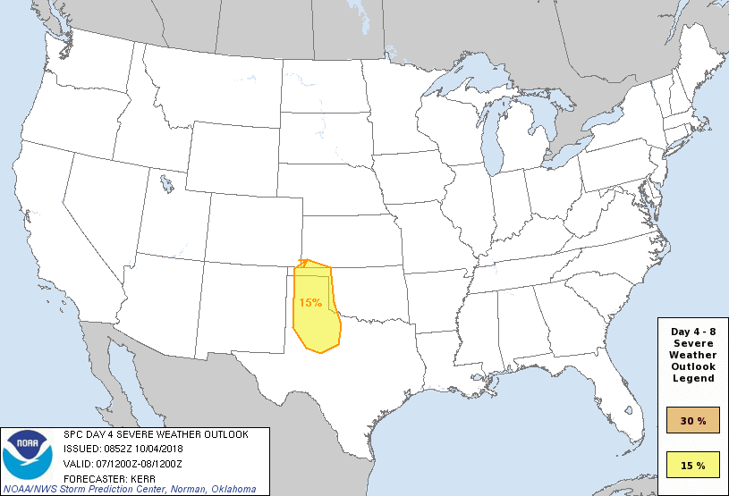 At this point, it is too early to know the exact timing and impact of severe storms this weekend. Highs will be in the mid 80s on both days.
NEXT WEEK - Our rain chances will linger into next week the storm system finally starting to move eastward. If the ridge in the east moves farther to the east, we will then mention the risk of potential severe storms for North Texas. But we will worry about that with time. Our best chance of rain looks to be Tuesday, when the system moves to the northeast. The latter half of the week should be dry with highs in low 80s to upper 70s. See the Texas Weather Discussion Video for more details. TROPICS - Hurricane Leslie is still in the Central Atlantic, far from land. It will continue north, then turn east later this week. A disturbance in the Caribbean has a 30 percent chance of development over the next five days as it moves to the north. VERY WARM SEPTEMBER - It was a warm September across North Texas with a mean of 78.1 degrees. The highest temperature we have seen was 95 degrees on the first day of September.
WELCOME TO OCTOBER - October is usually the fourth wettest month of the year for most of North Texas, and usually features falling temperatures as well. It has been as hot as 106 degrees, recorded on October 3, 1951. Subsequently, it has been as cold as 24 degrees, recorded in October 30, 1917. Earliest first freeze ever recorded for DFW was on October 22, 1898. TODAY - We are forecasting mostly sunny skies today with any showers to the south few and far between. A few clouds will linger, and the high will be in the upper 80s. REST OF THE WEEK - An upper ridge will continue to hold over the southern U.S., which will lead to more warm and humid afternoon weather. This means mostly sunny days, fair nights, and above average temperatures. The high will be in the upper 80s tomorrow, followed by upper 80s Thursday and middle 80s on Friday. This is about five to seven degrees above the average high of 83 degrees on October 1st. THE WEEKEND - A very high amplitude pattern develops in the U.S. with a cold trough over the northwestern U.S. followed by a strong ridge to the east. The trough will do a good job of pushing a cold front down our way, which will mean cooler temperatures and, of course, more rain chances. We will keep rain chances for the weekend to a minimum, based on current trends of the ridge not making it all the way down south. We will maintain partly to mostly cloudy skies for most of the weekend with afternoon highs in the low 80s. NEXT WEEK - The upper trough pushes the ridge to the east, which means we will have cooler temperatures and more frequent chances of scattered afternoon showers and thunderstorms as a result of the cold front. See the Texas Weather Discussion Video for more details. TROPICS - Tropical Storm Leslie is still meandering in the Central Atlantic. It could become a hurricane later, but will be stationary and will not impact any land. Tropical Storm Rosa in the Pacific will come closer to the southwestern US today, bringing moisture further north which could support a flood threat over the affected area for the next few days. |
Archives
April 2024
Categories |
 RSS Feed