
|
THE DOG DAYS OF SUMMER: Temperatures will be in the upper 90s to around the 100 degree mark for the rest of the workweek with mostly sunny skies and humid conditions. We could see 100° again for any of these days, just like what we saw with yesterday. At around 2:30 PM DFW Airport reached 100° for the first time this year. Usually our first 100° day is July 1st, so we are almost a month behind, which is a good thing because we are cooler than we normally are. THE WEEKEND: Not much change. We will be just a couple of degrees cooler with highs still around the 95-98° range. Isolated afternoon showers and storms will be possible, especially for our eastern counties. NEXT WEEK: Not much change. Most of the same summer weather is expected with highs back near the 100° mark with overnight lows in the upper 70s to low 80s. Very typical for this time of the year. See the Texas Weather Discussion Video for more details. 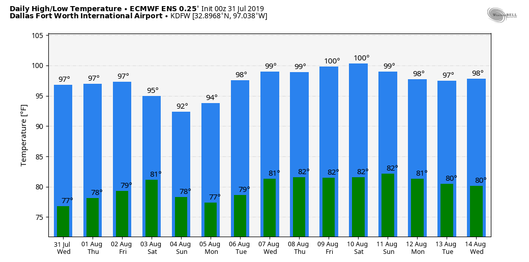 ANOTHER SUMMER MORNING: We will be forecasting classic summer time weather for the foreseeable future, meaning, mostly sunny skies with hot and humid conditions with highs in the upper 90s. Overnight lows will be in the upper 70s for most of the week. THE WEEKEND AND NEXT WEEK: Still not much change. The same classic weather pattern is in the forecast for the next several days with afternoon highs in the upper 90s with lows in the upper 70s and low 80s. Some showers and storms are possible Sunday, but they should remain more isolated. See the Texas Weather Discussion Video for more details. 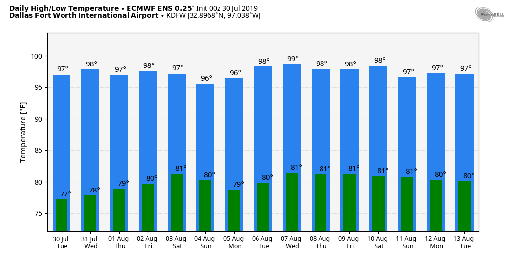 BACK TO NORMAL: Many areas are reporting temperatures in the upper 70s as well as low 80s in the urban areas. Today will be another mostly sunny day with humidity levels on the rise. The high will be in the 92-95° range for most communities. The average high for DFW for July 29 is 97°. A "front" will bring a small chance of isolated showers and storms this afternoon over a good portion of the region. Due to the usual spotty nature of the storms in summer time, it is nearly impossible to predict exact start/stop times, just be aware during the late morning/early afternoon hours. REST OF THE WEEK: Even though the humidity levels will rise again this week, it looks like the weather will stay dry over most of the region through the week with mostly sunny days and fair nights. A few isolated storms could show up over the northeastern corner of the state, but they should be stray and few and far between. Highs tomorrow and the rest of the week will be in the 95-99° range. THE WEEKEND: Not much change. We will forecast seasonal average temperatures along with the typical chance of "isolated, mostly afternoon and evening showers and storms" with highs in the mid 90s. Overnight lows will mostly lie in the mid 70s with a fair sky. NEXT WEEK: Any showers on Monday will continue to remain isolated, but we should trend drier for the rest of the week. Afternoon highs will remain in the mid 90s, just about where they should be for this time of the year. See the Texas Weather Discussion Video for more details. 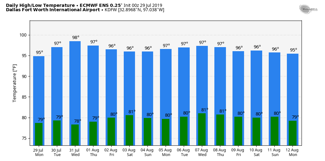 TROPICS: NHC is only giving a 20% chance of any tropical development over the Lesser Antilles, the rest of the Atlantic Basin remains quiet. 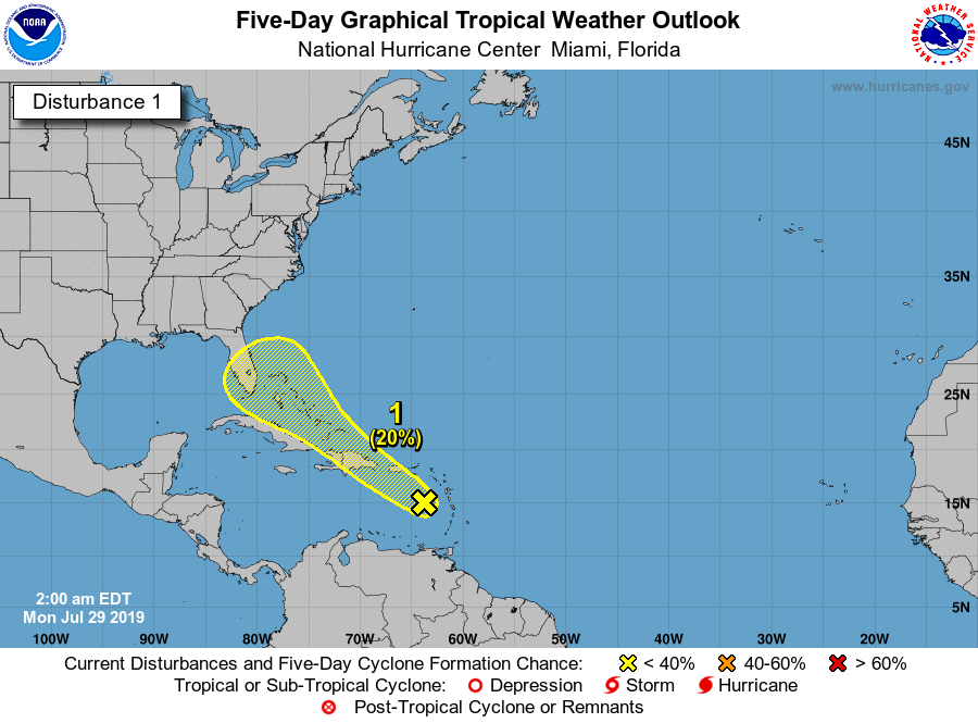 EARLY FALL PREVIEW: Temperatures are currently in 60s to mid 70° range this morning, with a most likely upper 50 reading in Glen Rose early this morning. We project highs around the 90-91° range today with mostly sunny skies and lower humidity values. THE WEEKEND: Humidity values begin to slowly increase, and highs will be in the mid 90s with mostly sunny skies and higher humidity. Overnight lows stay in the low to mid 70s with a fair sky. NEXT WEEK: A boundary has the small chance of bringing isolated showers to parts of North Texas on Monday. We project afternoon highs to be in the upper 90s once again, very seasonal for this time of the year. See the Texas Weather Discussion Video for more details. 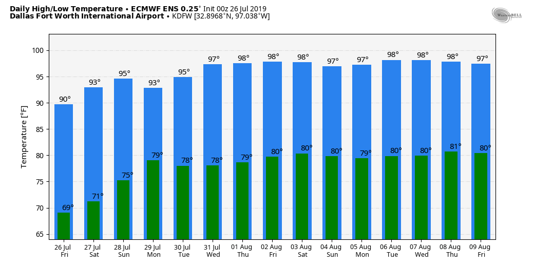 TROPICS: The Atlantic Basin remains quiet, and no new tropical cyclones are expected this week.
NEAR RECORD LOWS: DFW Airport recorded a temperature of 69° this morning. The record low at the same site is 65° which was set in 1915. As you can tell, it feels more like a fall morning with a very dry airmass, cooler temperatures, and fair conditions. Today will be mostly sunny and warm again with highs around 90°. Tonight will still remain cool with overnight lows around 70° with a fair sky. Then, we slowly warm on Friday with highs in in the 92-95° range. THE WEEKEND: Not much change. We begin to slowly warm up through the weekend with mostly fair skies. Highs will be around the mid 90s with a mostly sunny sky each day. Humidity levels increase, so we will introduce the chance of a stray storm during the afternoon. We will see overnight temperatures in the mid 70s this weekend. NEXT WEEK: We go back to seasonal weather with highs mostly in the upper 90s with humid conditions and a mostly sunny sky. A disturbance might bring the chance of isolated storms Monday evening. But most places stay dry for the week. See the Texas Weather Discussion Video for more details. 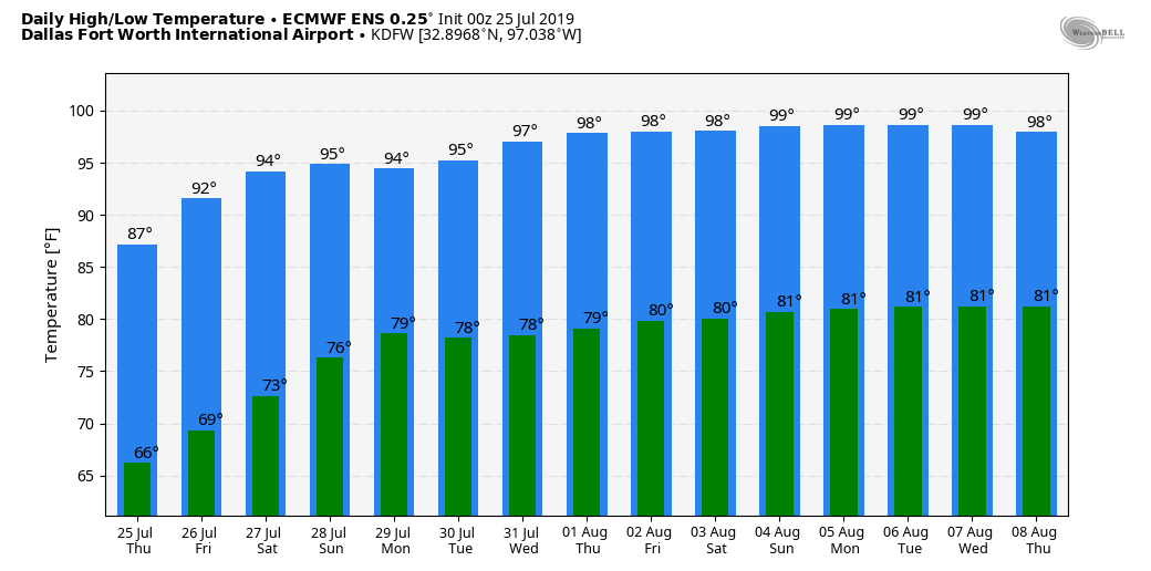 TROPICS: The disturbance over the Gulf of Mexico is not expected to develop due to lots of dry air and shear. The rest of the Atlantic Basin is quiet.
REFRESHING CHANGE: After a long awaited front came through North Texas Monday afternoon, dry air continues to flow into the state with a partly cloudy sky, lower humidity levels, and below average temperatures. DFW is reporting a low of 74° this morning while other sites report lows in the low to mid 60s, some cities even seeing record lows, like Abilene. We will probably reach the upper 80s today, but that is still ten degrees below our average high. Tonight will be fair and cooler once again as temperatures drop into the 60 degree range with upper 50s possible near the cooler valleys. TOMORROW AND FRIDAY: Not much change. Mostly sunny days, low humidity levels for summer, followed by fair, pleasant nights. Highs will be in the low 90s tomorrow, followed by mid 90s on Friday. THE WEEKEND: Moisture levels will rise, humidity values will increase, and we will forecast hotter, humid weather with highs in between 92-97°. NEXT WEEK: We will go with the standard mid-summer forecast through the weekend. Partly cloudy, hot, and humid each day with the risk of a passing afternoon shower in a spot or two. Highs will mostly be in the mid 90s, right at seasonal averages for late July. See the Texas Weather Discussion Video for more details. 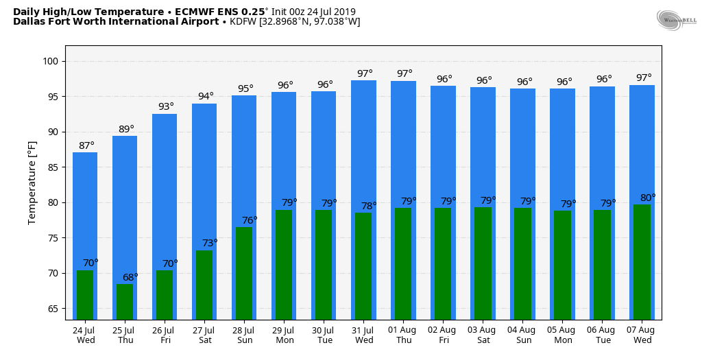 TROPICS: Tropical Depression Three dissipated yesterday morning off of the Florida coast. The NHC is now looking at a disturbance in the vicinity of the stalled front across the Gulf of Mexico, giving it a 20 percent chance of tropical depression or storm formation. 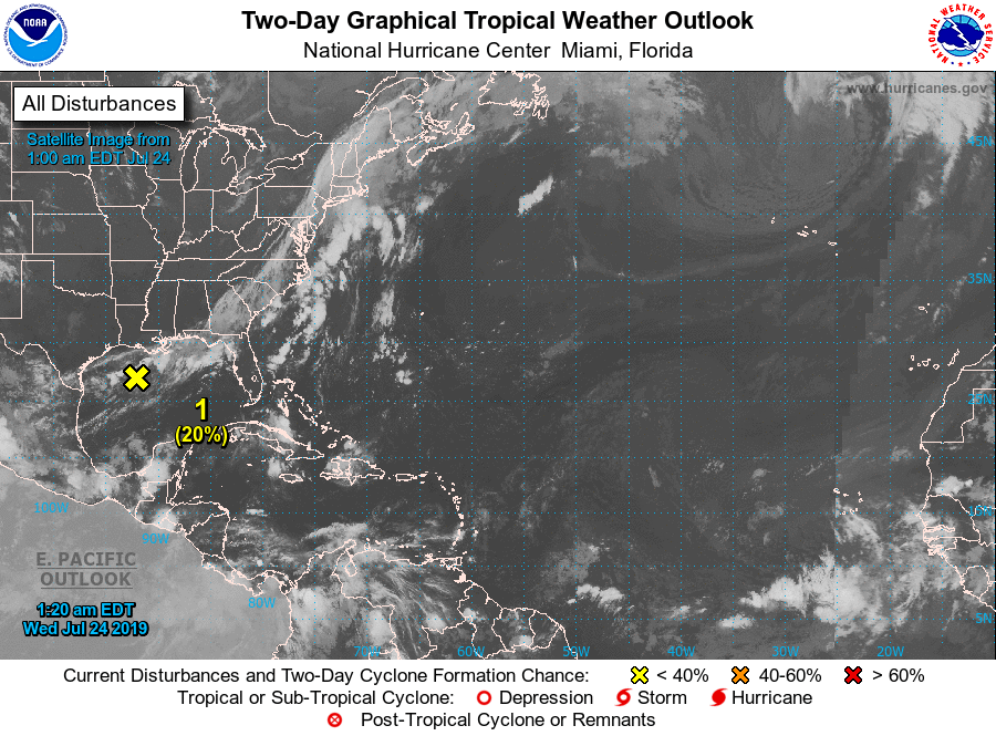 TYPICAL SUMMER MORNING: Temperatures are in the mid to upper 70s with a couple of upper 60 readings with fair skies this morning, but we will see overnight lows in the upper 60s for the coming days, which will feel very refreshing. BREATH OF FRESH AIR: The rest of the week will feel very pleasant for mid-summer; Sunny days, lower humidity, no afternoon storms, and cooler nights. Highs will be in the upper 80s with lows well in the mid 60s. Some of the cooler areas will likely see lower 60s sometime this week. FRIDAY AND THE WEEKEND: We all know that dry air will not last long around here in the summer time. Moisture levels begin to rise again on Friday, which will lead to increased humidity values. Highs will be in the low 90s. Then, on Saturday and Sunday, look for seasonal weather with hot and humid conditions featuring afternoon highs in the mid to upper 90s. NEXT WEEK: For now, fairly routine summer weather is in the forecast; hot and humid conditions, mostly sunny skies with highs in the around 95-97 degrees. See the Texas Weather Discussion Video for more details. 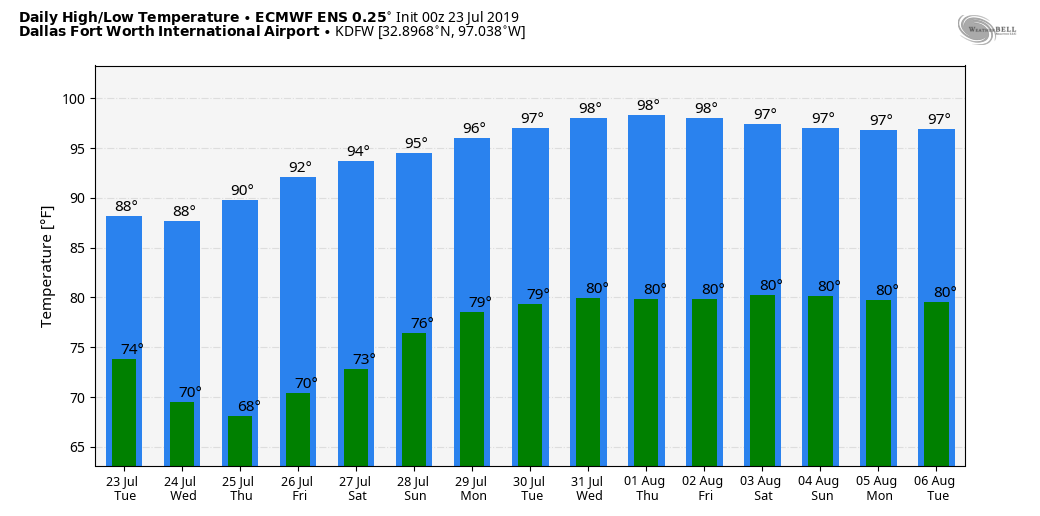 TROPICAL DEPRESSION FORMS: Tropical Depression Three has formed near the Central Bahamas. It is expected to remain a tropical depression as it stays off of the mid-Atlantic coast, and is expected to dissipate within 48 hours. No threat to the Gulf of Mexico. The rest of the Atlantic Basin remains quiet. 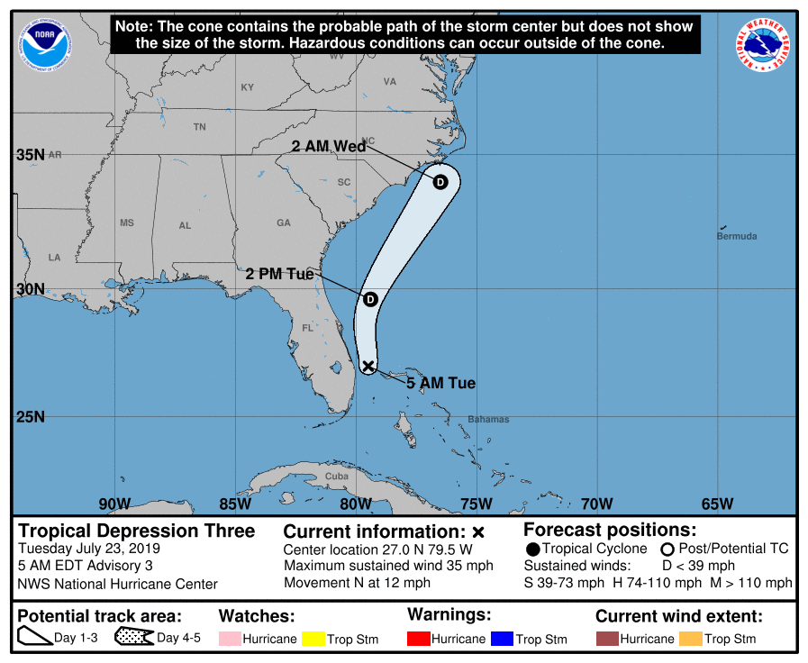 TYPICAL SUMMER MORNING: Temperatures are currently in the upper 70s to low 80s around the metroplex, which is pretty average for this time of the year. A rare summer time cold front will arrive in North Texas this afternoon, which may bring the chance of isolated showers and storms, especially for our southernmost counties. We will not experience cooler temperatures until the next day, and afternoon highs will be around the 95° range. TUESDAY AND THE REST OF THE WEEK: We will forecast highs in the upper 80s for Tuesday and probably Wednesday as well, which is ten degrees below our average high for this time of the year. Lower humidity values are also likely with mostly sunny skies. Highs will be close to the mid 90s by Friday. THE WEEKEND: Not much change. Each day will feature highs in the mid 90s with mostly sunny skies with a southerly wind. We continue to stay dry for the weekend. NEXT WEEK: We will forecast average summertime weather with mostly sunny skies. Highs will be in the mid to upper 90s again with dry conditions. No signs of any changes in the pattern for the foreseeable future. See the Texas Weather Discussion Video for more details. 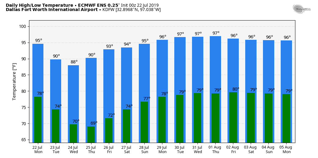 TROPICS: A disturbance in the Bahamas has a small chance of developing within the next five days. However, models currently point that the disturbance will curve to the North Atlantic, staying far away from land. The rest of the Atlantic Basin remains quiet. 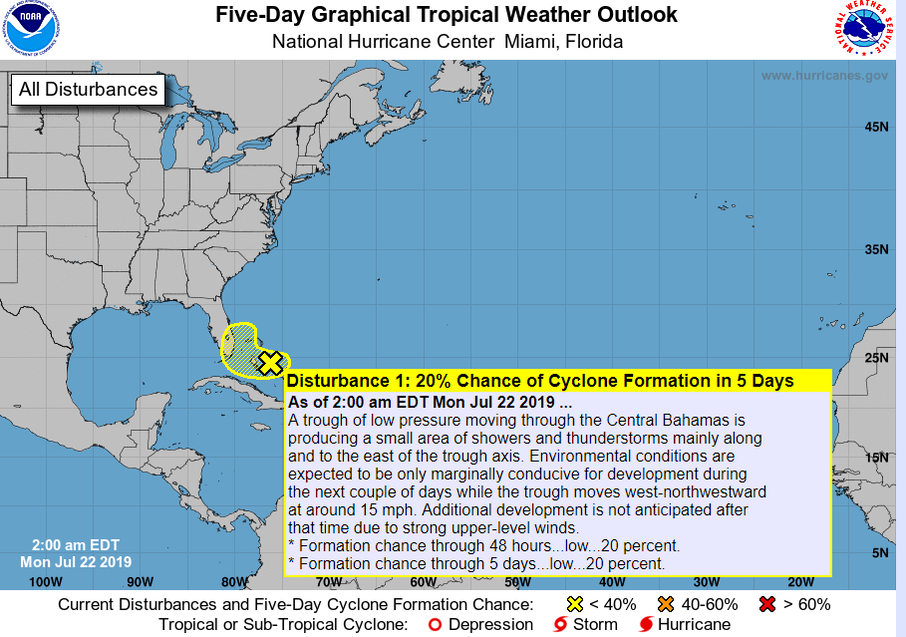 HOT AND DRY: Similar to yesterday, today will be mostly sunny and dry with highs in the mid to upper 90s in the afternoon. Tonight will feature fair skies with overnight lows in the low 70s. THE WEEKEND: Not much change. Each day features highs in the upper 90s with lows in the low 70s. NEXT WEEK: A cold front comes through Monday afternoon, so we will mention the chance of mostly isolated showers and storms Monday and Tuesday. Cooler, drier air filters in from the north, and afternoon highs will be in the upper 80s to low 90s throughout the entire week, which will definitely feel nice. The CPC (Climate Prediction Center) predicts a good chance of below average temperatures for the next 6-10 days. See the Texas Weather Discussion Video for more details.  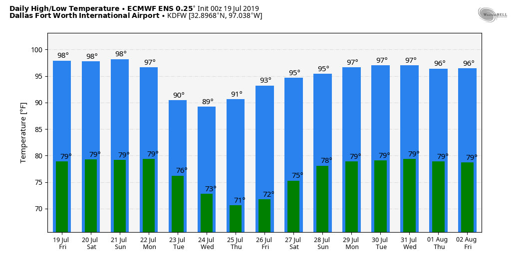 DROUGHT UPDATE: North Texas continues to remain drought-free. However, severe drought conditions are starting to appear more for parts of South Texas. Some of those issues may be rectified if we see showers and storms further south with next week's cold front. 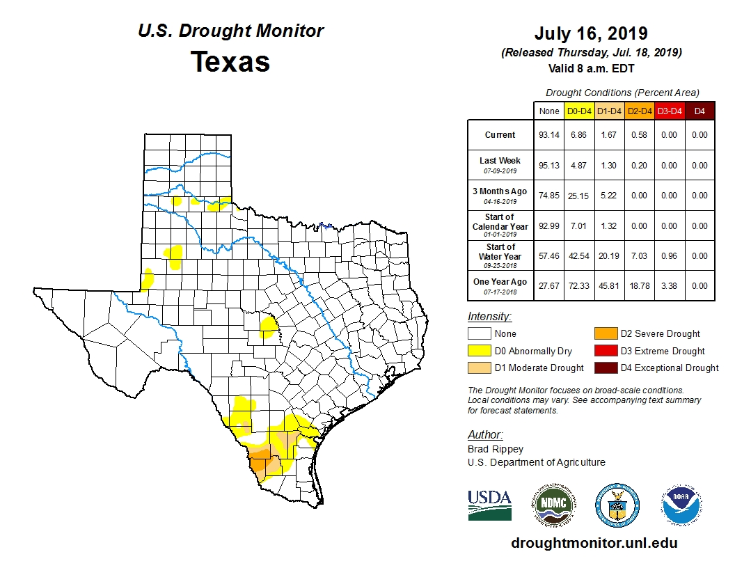 TROPICS: The Atlantic Basin continues to remain quiet for the next week. Tropical cyclone development is not expected.
SLIGHTLY COOLER: The next few days will feel just a tad cooler with mostly sunny skies skies, clear conditions with lower humidity values. We will maintain that forecast for tomorrow and the weekend with highs in the upper 90s. Humidity values should not rise to the point of needing another Heat Advisory this week. NEXT WEEK: A surface front comes through the region during the day Monday, and we will need to mention the chance of isolated showers and storms during the early part of next week and parts of midweek. Nothing indicates the possibility of widespread of rain, but just rain at times. Highs will also be in the low 90s for most of the week with lower humidity values throughout the entire week.  TROPICS: The Atlantic Basin remains quiet, and tropical cyclone development is not expected this week.
STILL VERY HOT: The Heat Advisory in effect for much of North Texas has been expanded to include parts of East Texas and more of the adjacent states as well. Hot and humid conditions will prevail this afternoon with highs mostly in the upper 90s with heat indices around 105-108°. REST OF THE WEEK AND THE WEEKEND: The trough associated with the "ghost of Barry" will continue to drift to the northeast, and that will clear to even drier conditions this week and the weekend. With mostly sunny skies, we expect highs in the upper 90s for the rest of this weekend and the weekend days. NEXT WEEK: An approaching surface front could introduce the chance of rain across a good chunk of Texas early next week, and the chance of showers and storms could shift into South Texas by mid-week. See the Texas Weather Discussion Video for more details.  TROPICS: The Atlantic Basin is quiet, and tropical storm formation is not expected this week. 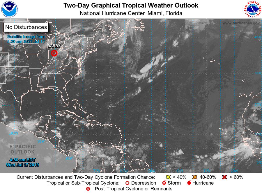 VERY HOT LATER TODAY: The remnants of Barry will continue to lift to the northeast, and the upper high from the southeast will take over, making for very hot conditions for the next several days. A Heat Advisory is in effect for much of the metroplex this afternoon through tomorrow evening for heat indices in the 105-110° range. Highs will be in the upper 90s with mostly sunny skies. REST OF THE WEEKEND THROUGH THE WEEKEND: Not much change. Each day will feature mostly sunny skies, hot conditions, highs in the upper 90s. A few clouds will remain possible, but showers and storms will be extremely limited as the upper high is still on top of us. NEXT WEEK: A surface front slips into the region Monday, and we could see a few isolated storms Monday and Tuesday. Other than that, expect mostly dry and hot conditions with highs continuing in the mid to upper 90s for most of the week. See the Texas Weather Discussion Video for more details. 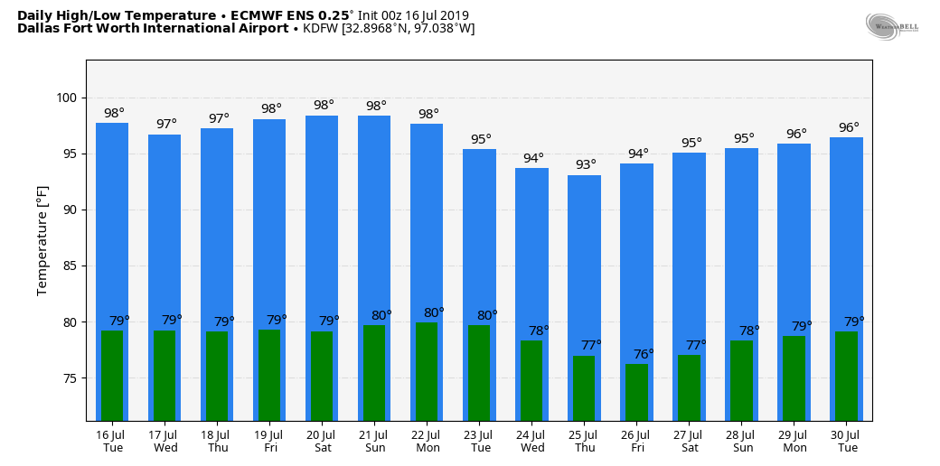 TROPICS: The remnants of Barry will continue moving to the northeast towards the North Atlantic. The rest of the Atlantic Basin remains quiet.
A BIT COOLER: Temperatures are in the low 70s with a few upper 60 readings across the region. Clouds will continue to decrease as the remnants of Barry continue to move to the northeast. Highs will be in the mid 90s with mostly sunny skies and lower humidity. THE REST OF THE WEEK AND THE WEEKEND: You will hear me say this a lot this week. We have entered the time of the year where the weather will not change much at all. Expect mostly sunny skies with hot and humid conditions with afternoon highs in the upper 90s each day. There is a chance that we will see our first 100° day tomorrow. Our average first 100° day for DFW is July 1, we are more than two weeks behind schedule... NEXT WEEK: A rare July surface front could bring back the chance of isolated to widely scattered showers and storms to parts of our region early next week. Otherwise expect much of the same summertime weather with afternoon highs in the upper 90s. See the Texas Weather Discussion Video for more details.  TROPICS: Barry is now a remnant low in Central Arkansas. It will still continue to produce heavy rain at times for areas along the Mississippi River Valley as it continues to the northeast. It should be fully dissipated by Wednesday. The rest of the Atlantic Basin remains quiet...
SOME RELIEF: Temperatures are mostly in the mid to upper 70s this morning. Arlington has already reported a temperature of 80 degrees this morning. We will see a bit of relief today and through the weekend, as slightly lower temperatures and humidity values are expected. We will still be in the mid 90s today with mostly sunny skies. THE WEEKEND: Not much change. Most of the region stays dry with mostly a mixture of sun and clouds. Highs will be in the low 90s with overnight lows in the low to mid 70s. NEXT WEEK: As we enter the "dog days" of summer, expect an increase of temperatures and humidity values next week with highs mostly in the upper 90s. DFW might record their first 100° day by Wednesday of next week. Our average first 100° day is July 1st, we will be over two weeks late.  TROPICAL STORM BARRY UPDATES: The system nearing the Louisiana coast was upgraded to a Tropical Storm yesterday morning. It is still a middle-end tropical storm with sustained winds of only 50 mph as it is fighting northerly shear and dry air around the circulation. However, some slight strengthening is possible today as it moves to Louisiana coast tonight or early tomorrow morning. This storm will likely maintain tropical storm status . Barry will weaken as it moves northward near the Mississippi River Valley this weekend. 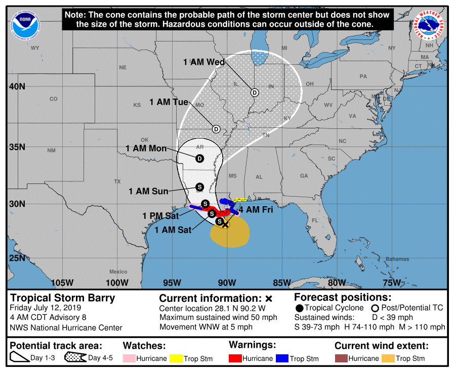 *A Tropical Storm Warning is in effect for the Mouth of the Pearl River to Grand Isle, Lake Pontchartrain and Lake Maurepas including New Orleans, and Intracoastal City to Cameron. *A Storm Surge Warning is in effect for Intracoastal City to Shell Beach *A Storm Surge Watch is in effect for Shell Beach to Mississippi/Alabama Border and Lake Pontchartrain *A Tropical Storm Watch is in effect for East of the Mouth of the Pearl River to the Mississippi/Alabama Border. *For the coastal areas, understand that it will mostly rain at times and will not be continuous. However, dangerous rip currents are likely along the coastline, and double red flags are flying in many places, which means the water is closed, but the beaches are open. *A Flash Flood Watch is in effect for parts of Southern Louisiana, Mississippi, Alabama, and the Florida Panhandle. Anywhere from 1-2 feet of rain is expected for areas surrounding Baton Rouge and New Orleans with a high risk of flash flooding tomorrow and Saturday. Life-threatening flooding is expected Saturday for New Orleans and Baton Rouge.  Elsewhere, expect anywhere from 4-10 inches of rain for areas along and each of the Mississippi River Delta.
*The weather will improve along the Gulf Coast early next week as Barry weakens to a remnant low and moves away from the coastline. See the Texas Weather Discussion Video for more details. ON THIS DAY IN 1936: From the 5th to the 17th of July, temperatures exceeding 111° ended the lives of 1,180 people, most of which were the elderly and infants, during the most prolonged, deadliest heat wave on record. 400 of the deaths were caused by people drowning attempting to seek refuge from the heat. The heat was so intense that steel rain lines and bridge girders twisted, sidewalks buckled, crops wilted and fruit baked on trees. Some of the temperatures include 112° at St. Albans and Emerson, Manitoba, 111° at Brandon, Manitoba, and 108° at Atikoban, Ontario and Winnipeg, Manitoba. A BIT COOLER: Temperatures are in the mid 70s early this morning, a few degrees cooler than in recent days. Just like most days, today will feature dry hot and humid weather with highs in the mid to upper 90s, and that will be the case for the foreseeable future. Nothing much will change with our weather pattern for the weekend or next week. ALL EYES ON THE GULF: A tropical storm is expected to form today in the northern Gulf of Mexico; it's name will be Barry. The NHC has designated it as "Potential Tropical Cyclone Two" for the time being. It will continue to move westward, and curve to the Louisiana coast where it is expected to landfall during the day Saturday as a category one hurricane. 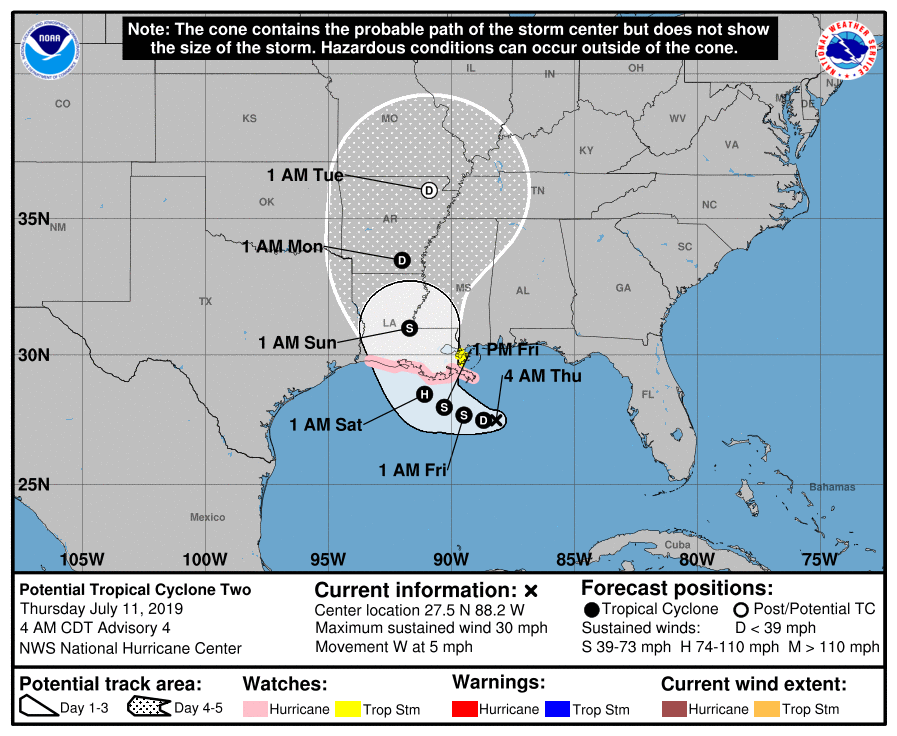 GULF COAST: *A Storm Surge Watch is in effect from the mouth of the Pearl River to Intracoastal City. *A Hurricane Watch is in effect from the mouth of the Mississippi River to Cameron. *Lastly, a Tropical Storm Watch is in effect from the mouth of the Mississippi River northward to the mouth of the Pearl River. *The main storm surge and wind threat will be along the segments mentioned above along the Louisiana coast beginning Friday night lasting into the day on Saturday as Barry approaches. Dangerous rip currents are likely Friday and the weekend, so expect double red flags flying. *For ALL areas to the east and northeast of Lake Charles, please be advised that heavy rain bands are expected at times tomorrow through Sunday. These bands will be well to the south and east of the center of the circulation. Also, brief, isolated tornadoes and/or waterspouts will be possible with these bands. *Rain amounts of ]2-4 inches is expected for areas near Shreveport and points east. Lighter amounts are possible to the west. The heaviest rainfall will lie in Southern Louisiana, where over 15 inches is likely.  *The weather for the coast should trend calmer by early next week.
See the Texas Weather Discussion Video for more details. ALREADY WARM: We already have low to mid 80 readings across the metroplex this morning with very humid conditions... Temperatures will be in upper 90s again with mostly sunny skies today, and a Heat Advisory remains in effect for ALL of the North-Central Texas region until 7PM today. Then, a complex of strong thunderstorms from Oklahoma will move southward towards the metroplex, affecting the area at around 10-12PM. Gusty winds are possible, as well as some hail at times, but do not expect anything widespread. REST OF THE WEEK THROUGH NEXT WEEK: Not much change. Each day will feature mostly sunny skies with a few clouds in the mix, hot and humid conditions with hidden daily chances of "spotty, mostly afternoon and evening showers and storms". Highs will be in the mid to upper 90s each day. We will maintain a dry forecast for North Texas for the weekend for the time being. ALL EYES ON THE GULF: A disturbance that is now in water at this point is expected to become better organized over the coming days, ultimately becoming a tropical storm within the next 48 hours. It's name will be Barry if it becomes a tropical storm. 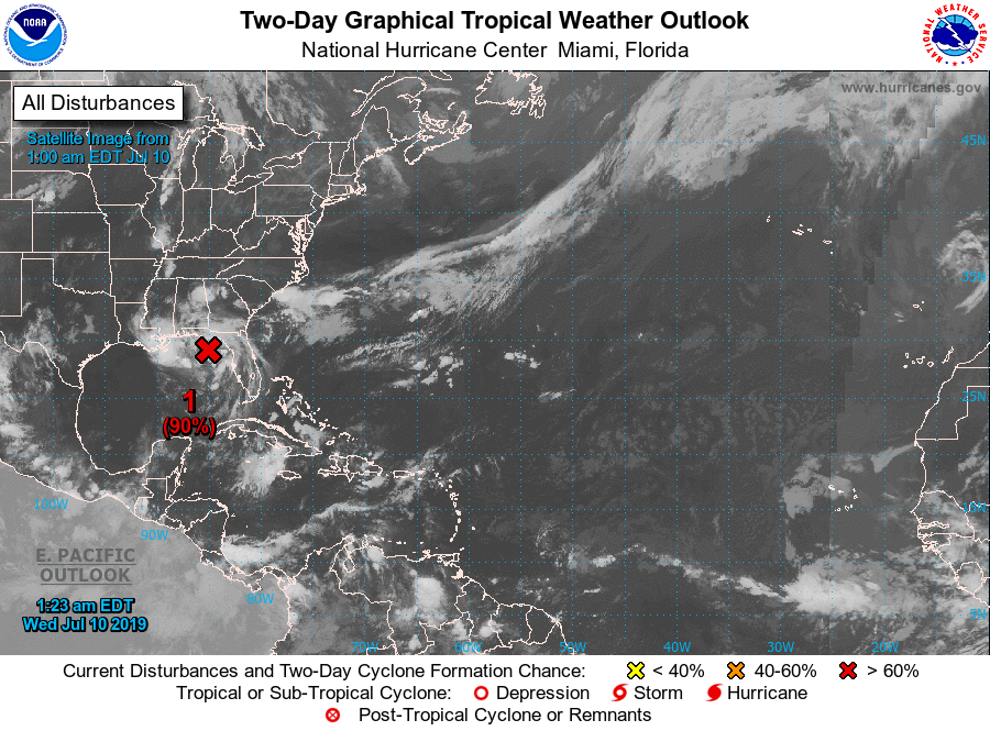 It will drift to the southwest slowly. bringing unsettled weather to the Central Gulf Coast inland into parts of the Deep South over the coming days. Here are the main takeaways. -Intensity guidance this morning is going a little more on the aggressive side on the storm, suggesting it might be a high-end tropical storm to minimal hurricane by Saturday. For now, we are still expecting this to remain below hurricane strength, but this will definitely change within the coming days. 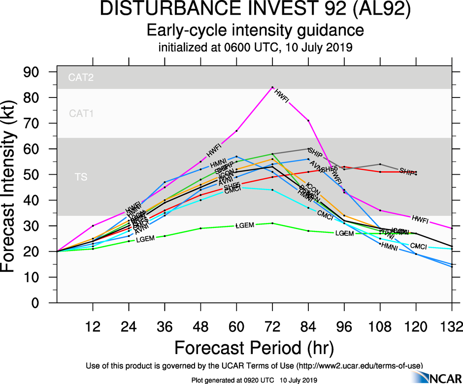 -The main impacts from this thing will come from heavy rain which may lead to flooding, and rough surf/rip currents. Gusty winds will also be likely, and a few brief waterspouts/tornadoes are possible Thursday and Friday along the coast. The SPC has a "marginal risk" for severe storms defined for parts of the Florida Panhandle, and the coasts of Alabama, Mississippi, and Louisiana. -The system should drift inland somewhere over Louisiana Saturday evening. Do not focus on the circulation center too much. Heavy rain will be possible a couple hundred miles to the east and north of the center of circulation. 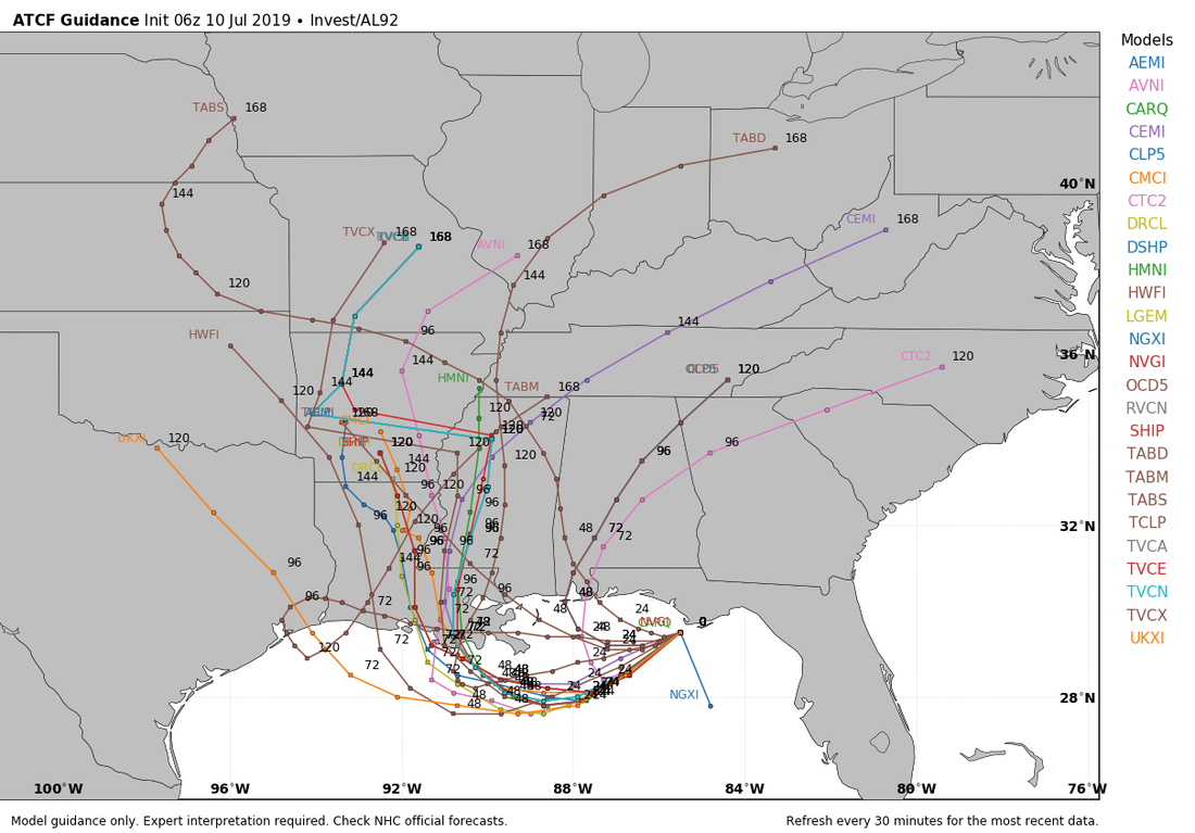 -Once we establish a center of circulation in the Gulf, there will be much better confidence in impact and exact tracking forecasts. This should happen later this evening.
See the Texas Weather Discussion Video for more details. VERY HOT AND HUMID DAY: A heat advisory is in effect for much of North and East Texas today where highs will be in the upper 90s and humidity values will make it feel like 105-110 degrees. However, whether in the heat advisory or not, everyone will be hot and humid with highs in the upper 90s. A few spotty storms could form this afternoon, but they should be fairly isolated. REST OF THE WEEK: The heat advisory will last into tomorrow afternoon with highs still in the upper 90s. A surface front will drop from the north, enhancing our chances of isolated showers and storms on Thursday. We will still stay mostly dry on both days with highs in the upper 90s. THE WEEKEND: This weekend's weather will be largely dependent on how a developing tropical system in the Florida Panhandle behaves. This is what we know about Invest 92L. *A tropical depression or storm is expected to develop in the Gulf of Mexico by Friday. If it becomes a tropical storm, its name will be "Barry". *It is highly unlikely that the system reaches hurricane strength. The main impact will be heavy rain inland, followed by rough rip currents towards the coast. The SPC has a "marginal risk" (1/5) for severe storms defined for the coasts of Mississippi, Alabama, and the western Florida Panhandle to address the possibility of an isolated tornado or waterspout Thursday. *Once it gets into the water, the system will begin to drift southwestward, with most models having it somewhere around Lake Charles and the Texas border by Saturday evening. However, heavy rain will extend to the north and east by a couple hundred miles. 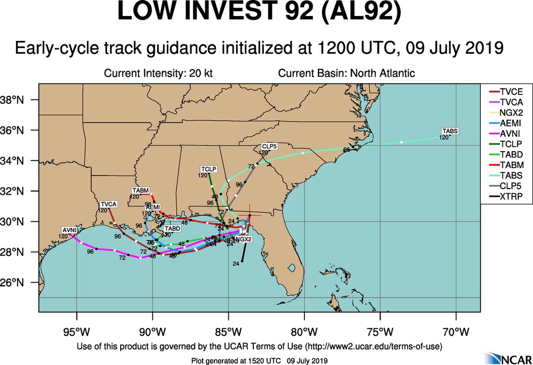 The Weather Prediction Center has the heaviest rain from the Mississippi Coast, mainly impacting North Charles, to southeast Texas. Lighter amounts are forecast to the east and northeast of the center. 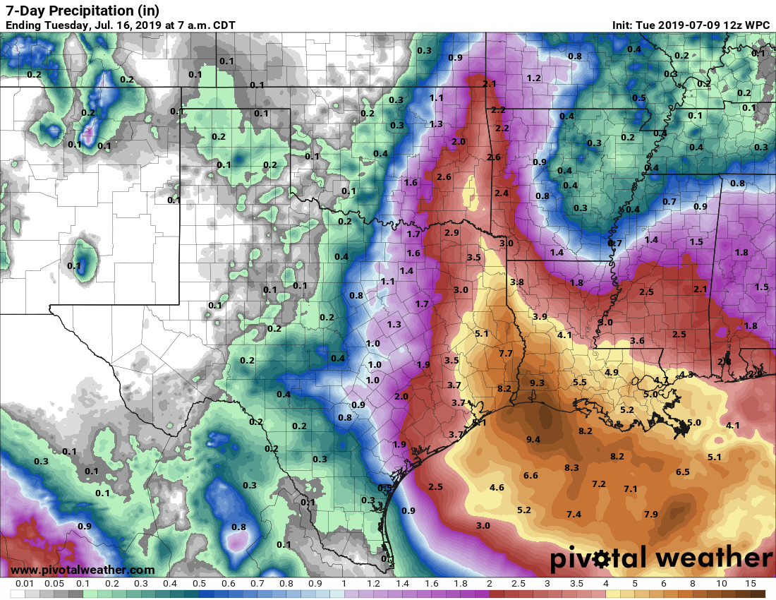 Please be advised that this map right now is very very arbitrary. Confidence is very low in forecasting the area of heavy rain until this system develops. In other words, the forecast will change in the next few days.
*For North Texas, I will continue to keep a dry forecast for the weekend through early parts of next week. However, if we see a notable shift to the west, that can change, so stay tuned NEXT WEEK: Expect routine July weather across Texas with the usual daily chance of "isolated, mostly afternoon and evening showers and storms". Highs will be in the low to mid 90s. See the Texas Weather Discussion Video for more details. ON THIS DAY IN 1979: Hurricane Bob formed in the Gulf of Mexico, becoming the first Atlantic Hurricane to receive a male name. RADAR CHECK: Scattered showers and storms are continuing to develop in West Texas and are moving east this afternoon. Only thing to be concerned with is frequent lightning at times and gusty winds. There is no way of determining exact start/stop times of storms because of the scattered nature and small scale features. Just make sure to keep a close eye on the radar if you are outside. If you don't see rain, expect a mix of sun and clouds with hot and humid conditions. Highs will be in the upper 90s this week with heat indicies in the triple digits. REST OF THE WEEK THROUGH NEXT WEEK: To be completely honest with you, we have reached the time of the year where the weather doesn't change much at all. Each day will feature sunshine with some clouds around, humid conditions, daily hidden chances of "isolated, mostly afternoon and evening showers and storm(s)" with highs in the upper 90s. There will be no way in determining exactly where and when the storms form because of small scale features that not even the mesoscale models can resolve. Heat indices will be in the 100-107 degree range each day. See the Texas Weather Discussion Video for more details.  TROPICS: There is a broad low over the Gulf of Mexico that has a high (80%) chance of becoming a tropical depression within the next five days. What we don't know is where the system will end up. Some of the global models have hinted the system moving west towards the Texas/Louisiana Coast. More are starting to pick up on that idea. One way or another, expect heavy rain where the system does move into land. The rest of the Atlantic Basin remains quiet.  |
Archives
April 2024
Categories |
 RSS Feed