
|
Hey guys! Shorter midweek post ahead.
The heat is unrelenting. We are seeing yet another day in the high 90s and it looks like this heat spell will continue for the foreseeable future. A few weekday updates are ahead. THURSDAY: Expect a high of around 99 today with a heat index of around 105. It will continue to be sweaty weather so continue to hydrate and stay cool. Overnight it’ll reach a low of around 80 degrees, which is still quite warm for a low so make sure to hydrate even if it’s dark outside. FRIDAY: A high of around 98 with another heat index around 105. Humidity will be slightly less than Thursday but not noticeably. The low will hopefully dip below the 80s into the high 70s overnight. Look forward to future updates and sorry for the lack of info! It’s been a relatively informationless week. Stay cool! -Colin Welty 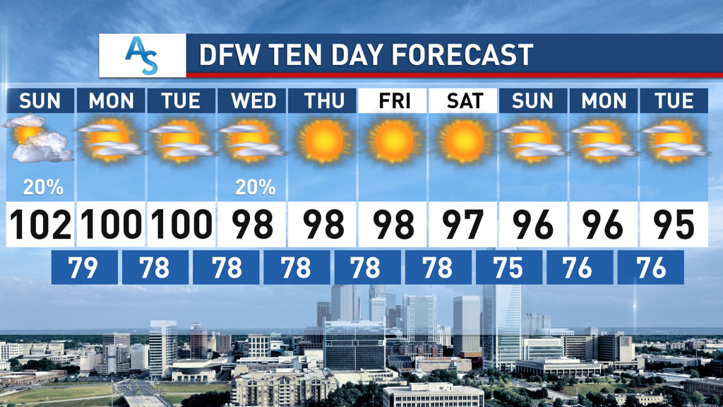 HOT HOT HOT:
Hot weather has blanketed the North Texas area as of late with the sun baking down upon us. Many of us are experiencing our first triple digit days today—many in West Texas are seeing near record heat as well. Somehow, as of writing this, DFW has yet to hit 100 this year but that will definitely change with our hot start to this week. Many places are also seeing heat advisories, so it’s imperative that you drink tons of fluids, wear sunscreen, and keep in the shade at all possible times, ESPECIALLY when staying outside for prolonged periods. While this is a great time to be swimming or enjoying your local park, remember that just being near or in water doesn’t keep you hydrated, so please drink water. And, don’t expect these hot temperatures to disappear anytime soon. LOOKING FORWARD: Sunday is sure to be the hottest day of the year so far with Dallas projected to reach 102 degrees. While this pales in comparison to some of the July heat we’ve experienced in years past, it’s sure to be intense and important to stay on top of. Don’t put yourself in a compromised position because you were ill-prepared for that classic Texas summer heat. The good news is we are late experiencing our first stretch of triple degree weather. The bad news is, it’s coming up, and it’s going to be a rough week for weather as there doesn’t look to be much break from the core of this heatwave. The subtropical ridge is moving over our state and positioning itself right in the heart of Texas, bringing us multiple chances at triple degree weather, though parts of Central and West Texas will likely see much worse temperatures than we do. That being said, heat indices of up to 110 degrees are not out of the question. One thing that is looking somewhat plausible is that the adversely high temperatures of our heatwave could be diminished if atmospheric convection (cumulus clouds mainly) appears each afternoon like some models are suggesting. The bulk of our heatwave will occur from Sunday-Tuesday, with temperatures slightly dropping off as the week progresses. There is also a LOW but nonzero chance of some pop up showers tomorrow as well, mainly in the later part of the day, as convective storms from Oklahoma dissipate as they move southward. If the dissipation gets delayed and the storms move more quickly with more moisture than anticipated, then parts of North Texas could be lucky enough to see some brief relief from the grief of heat. However, confidence in this is low. LATE WEEK: There isn’t too much to report here other than the low potential for some scattered showers and storms Wednesday. Expect to continue to see high temperatures and look out for heat advisories. Continue to drink plenty of water and seek the coolness of the A/C whenever possible. It’ll be hot out there in Texas. Stay cool, stay hydrated, and stay weather aware! -Colin Welty QUIET AFTERNOON: As forecast, the radar is very quiet this afternoon. The sky is mostly sunny, and temperatures are in the mid 90s across the area with heat indices well in the triple digits. There are a few showers for the counties to the northeast, but, those will dissipate by sunset.
THE WEEKEND: Get ready for tomorrow and Sunday to be the hottest days of the year. Highs for the weekend will be in the triple digit mark for most places with heat indices in the 105-110°+ range with mostly sunny skies. Despite potential cloud cover Sunday, it will not be sufficient to suppress the continuing heat, so the Heat Advisory has been extended until Sunday evening. Some places that do not see clouds on Sunday will reach Excessive Heat Warning criteria, and an upgrade to that may be warranted. One way or another, prepare for the hottest weekend of the year. NEXT WEEK: Not much change to the weather forecast. Mostly sunny skies, oppressive heat, highs in the low 100s with heat indices in the triple digits, and non-zero rain chances continue. You may see slight fluctuations in temperature, but, you will not feel the difference. TROPICS: Tropical Storm Fay is moving into New Jersey; maximum sustained winds are 60 mph. Flash flood warnings are in effect for the New York City boroughs this afternoon, where heavy rain continues to fall. The remnant circulation will move into Eastern Canada tomorrow. The rest of the Atlantic basin, including the Gulf of Mexico, remains very quiet for now. Keep in mind the peak of the hurricane season comes in August and September. ON THIE DATE IN 2005: Dennis made landfall as a category three hurricane near Navarre Beach. The hurricane had reached Category 4 strength for the third time earlier in the day on July 10 as it approached Florida, attaining its lowest barometric pressure of 27.46?. This ranked Dennis as the strongest hurricane in the Atlantic basin to form before August; however, this record was broken just six days later by Hurricane Emily, which surpassed Dennis and attained Category 5 status. Colin Welty will continue the blog update this weekend. I will be on vacation next week, so, Logan and Colin will hold down the daily blogs next week. Expect MY next blog update on Monday, July 20th... Enjoy the weekend!!! Donovan Neal Owner - ApexStorm RADAR CHECK: As advertised, isolated showers and storms are non-existent across the region this afternoon. The sky is mostly sunny with temperatures in the middle to upper 90s with heat indices well within the triple digits. Temperatures overnight will stay in the upper 70s. TOMORROW THROUGH THE WEEKEND: Unfortunately, tomorrow looks to be the last time with highs in the upper 90s for a few days. Look for a high in the triple digits this weekend as heat levels continue to rise. A Heat Advisory is in effect through Saturday evening, but, I do expect that to get extended. An Excessive Heat Watch may be needed for areas to the south and east of the metroplex. One way or another, it will stay VERY hot across NTX over the forecast period. 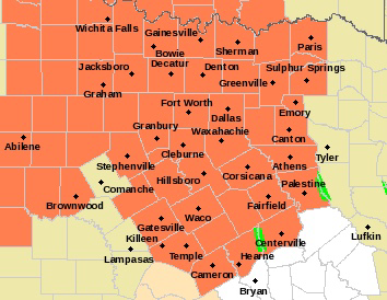 NEXT WEEK: Hot, humid weather is the main headline of weather through the course of next week. Basically, what you would expect around here in July. Highs in the upper 90s to triple digits, mostly sunny skies, and a non-zero chance of an isolated shower or storm during the daytime heating process. TROPICS: Looks like Tropical Storm Fay has formed out of the northern banks of the Carolinas. it will move northeast in coming days, hugging the upper Atlantic coast of the U.S. The system is expected to produce locally heavy rainfall that could cause some flash flooding across portions of eastern North Carolina, the coastal mid-Atlantic, and southern New England during the next few days. Gusty winds are also possible along the North Carolina Outer Banks today, and along the mid-Atlantic and southern New England coasts Friday and Saturday. The rest of the Atlantic basin, including the Gulf of Mexico, is very quiet. ON THIS DAY IN 1979: Hurricane Bob was born in the Gulf of Mexico, becoming the first Atlantic Hurricane to be given a male name. Look for the next Texas Weather Blog update at around noon tomorrow.. Have a great night! Donovan Neal Owner - ApexStorm Double-tap to edit.
LAST CHANCE OF RAIN FOR A WHILE: As an upper trough lifts away from the region, so will the daily chances of scattered showers and storms. Some isolated showers will remain possible to the east of 35, but those will, of course, dissipate by sunset. Highs will continue to be in the mid 90s through the afternoon. The average high for DFW is 95°. 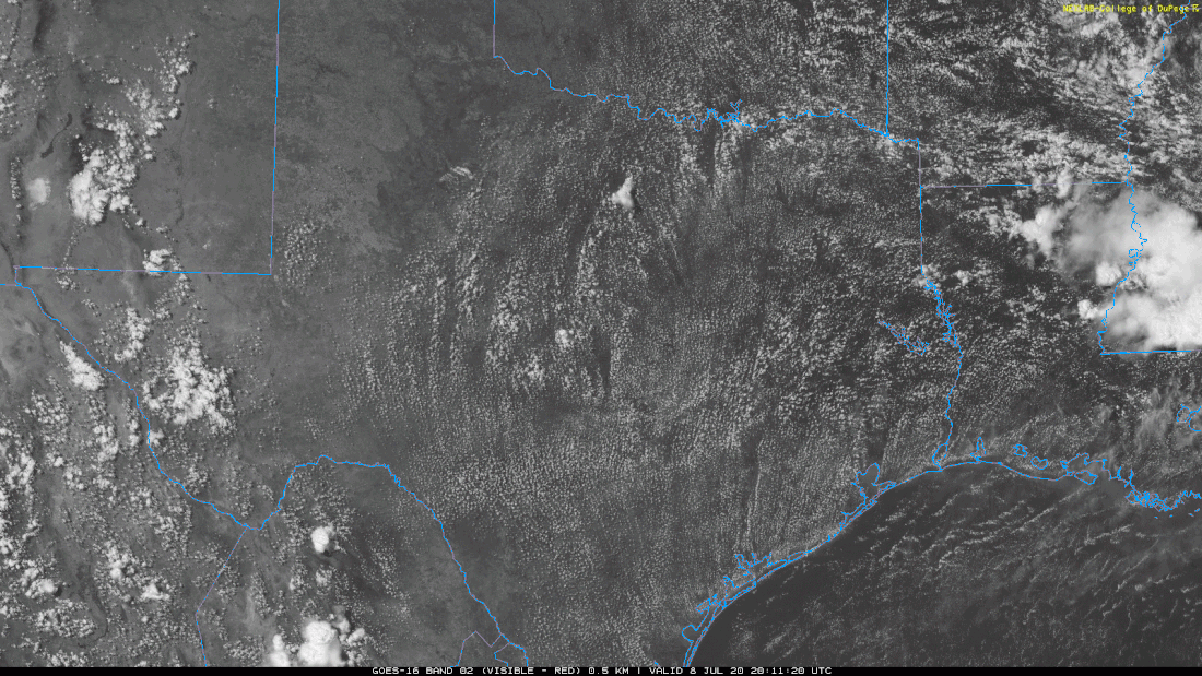 TOMORROW THROUGH THE WEEKEND: Tomorrow will be the beginning of many REALLY HOT days that are in store for North Texas. The afternoon highs tomorrow and Friday will reach the upper 90s, with a few 100° readings in some of our western zones. Heat indices will have no problem reaching the 105-110° range, so, a Heat Advisory has been issued for all of North Texas until Saturday at the EARLIEST. I expect most places to observe their first 100° day of the year on Saturday. The average first 100° day for DFW each year is the first of July, so I think it's a good thing that we are a little behind schedule. Regardless, it is going to be very hot for the weekend. NEXT WEEK: The forecast for next week will feature high temperatures well in the century mark and oppressive heat indices. The rain chances will be minuscule to none for the foreseeable future, providing no relief to the classic summertime heat. The upper level ridge will continue to hold through next week, and, combined with sinking subsidence, we will experience the hottest temperatures of the year over the course of next week. Highs each day will be in the 100-105° range with overnight lows in the low 80s. Heat indices will soar into the 105-110°+ range, so the Heat Advisory will likely continue through most, if not all, of next week, with an Excessive Heat Watch or Warning possible. I can not stress enough how important it is to practice heat safety by staying hydrated, mitigating outdoor activities, and protecting family and pets. We are in a global pandemic, so, you shouldn't be outside anyways. Now, more than ever, is a good time to stay indoors. TROPICS: A broad area of low pressure located near the coast of northeastern South Carolina continues to produce a large area of disorganized showers and thunderstorms over the adjacent Atlantic waters and portions of eastern North Carolina. The low is expected to move northeastward near or just offshore of the North Carolina Outer Banks on Thursday, and then turn north-northeastward and move along the mid-Atlantic coast Friday. Environmental conditions are expected to be conducive for development, and a tropical or subtropical cyclone is likely to form within the next day or so. Regardless of development, the system is expected to produce locally heavy rainfall that could cause some flash flooding across portions of eastern North Carolina, the coastal mid-Atlantic, and southern New England during the next few days. Gusty winds are also possible along the North Carolina Outer Banks through Thursday and along the mid-Atlantic and southern New England coasts Friday and Saturday. 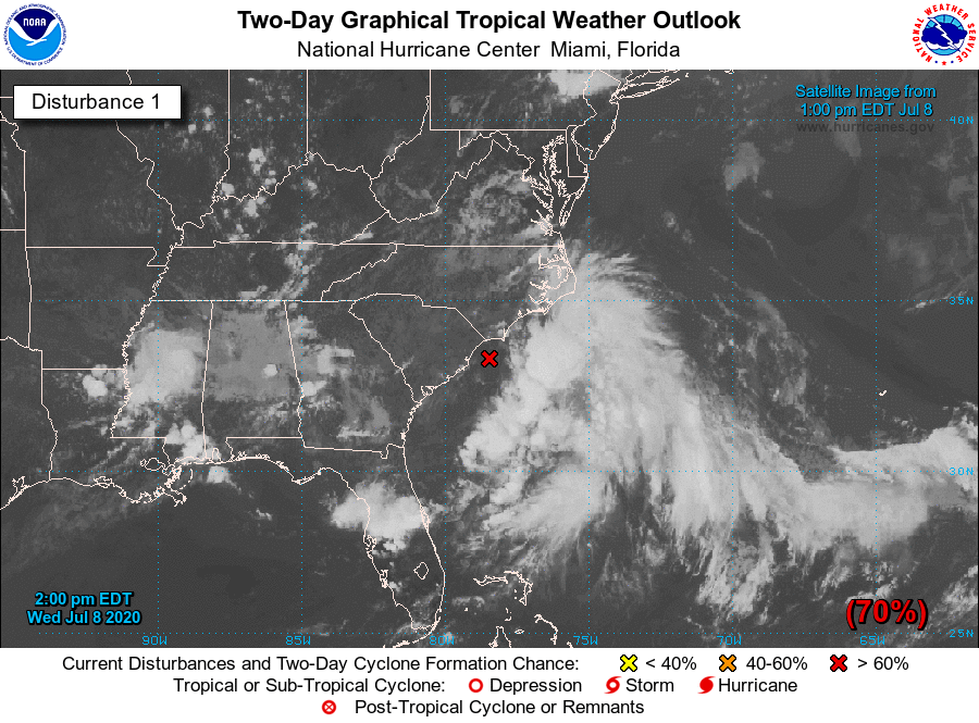 The rest of the Atlantic Basin, including the Gulf of Mexico, is quiet.
ON THIS DAY IN 2003: What may be the world’s highest dew point temperature was recorded at Dhahran, Saudi Arabia, in the Persian Gulf. A dew point of 95 degrees was recorded at 3 PM while the air temperature was 108 degrees. The apparent temperature at that time would have been 172 degrees. Look for the next blog update tomorrow at noon.... Have a great night! Donovan Neal Owner - ApexStorm Over the last few days, we've seen several rounds of thunderstorms, some of which have been severe. Another round is expected late this afternoon. Scattered t-storms are ongoing to the west of DFW (as of 2:35pm) with gusty winds and lightning. These will slowly shift east/southeast with time with a few clusters around this evening. 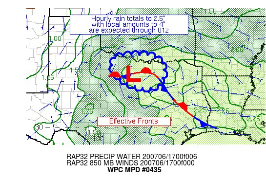 The WPC has issued a discussion for potential of 2-4" of rain this evening for DFW. Some of these storms may also produce some severe weather, primarily as damaging winds. Frequent lightning and small hail will also be possible. A brief break is expected overnight, but activity will pick back up just before daybreak tomorrow. Another round of thunderstorms is likely with gusty winds, heavy rain, and frequent lightning near I/20. One final round of storms is possible tomorrow afternoon, but should be more isolated to scattered in coverage. Severe weather isn't expected.
The ridge will become dominant late week, but a northerly flow aloft may allow for a storm complex to sneak in at some point this weekend east of I/35, but the chances appear low right now. A 600dm ridge at H5 will build back next week, and our first triple digits of the year (possibly highs beyond 105°) look likely with dry weather expected. Logan Shipley HOT, HUMID SUMMER WEATHER: The weather looks pretty routine for the holiday weekend across North Texas with hot, humid days, a partly to mostly cloudy sky, and the risk of scattered, mostly afternoon and evening showers and storms, generally between 12:00 and 9:00PM. Odds of any one spot getting wet is only about 1 in 5 each day. No way of knowing exactly where and when they pop up, due to small scale features that are not foreseeable. But, remember, when thunder roars go indoors... summer storms, as we saw yesterday evening, can be very effective lightning producers.
We project a high today between 95-98°. Then, the high today will stay in the mid 90s for the holiday weekend. NEXT WEEK: Moisture levels will still stay very high, and a broad upper trough develops over the region. We will maintain the chance of "scattered, mostly afternoon and evening showers and storms" for the first half of the week, before the showers thin out Thursday and Friday. Highs will stay in the mid 90s. TROPICS: The Atlantic Basin remains very quiet, and tropical storm formation is not expected for the foreseeable future. The peak of the hurricane season comes in August and September. ON THIS DAY IN 2014: Hurricane Arthur made landfall at 11:15 pm July 3, over Shackleford Banks, between Cape Lookout and Beaufort, at category two strength. It is the earliest hurricane to hit North Carolina in a season since records began in 1851. Widespread power outages were reported throughout coastal eastern North Carolina. Surge flooding up to 4 to 5 feet above normal was observed over the central and northern Outer Banks with portions of NC Highway 12 and U.S. Highway 64 closed in Dare County. The peak wind gust during the storm was 101 mph at Cape Lookout. We are on a holiday schedule, so no weather discussion tomorrow. But Logan Shipley will post fresh forecast notes on Sunday... Enjoy the weekend! Donovan Neal Owner - ApexStorm TYPICAL JULY WEATHER: Overall moisture levels remain the highest they have been in about three years. So, we will continue to roll with a persistent forecast this afternoon through Friday. Partly to mostly cloudy skies, hot, humid, with the chance of isolated, mostly afternoon and evening showers and thunderstorms. Highs will be in the 93-98° range, with heat indices continuing to be in the 105-110° range. As such, a Heat Advisory remains in effect for much of the coverage area today. 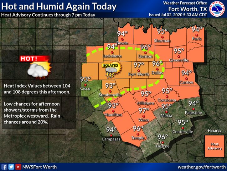 FOURTH OF JULY WEEKEND: The main westerly winds aloft (aka jet stream) will remain far to the north, and fairly typical July weather will continue across North Texas through Sunday. Partly to mostly cloudy, hot, and humid, with the chance of isolated to scattered, mostly afternoon and evening showers and thunderstorms. Most of the thunderstorms (not necessarily all) will form around 12:00-8:00PM, and the odds of any one spots getting wet is about one in three. No exact way of knowing where and when they form, you just have to pay attention to radar trends if you have any outdoor activities. Afternoon highs will be in the upper 90s.
NEXT WEEK: No real change in the forecast next week. Hot, humid summer weather will continue with the daily chance of "isolated, mostly afternoon and evening showers and storms". No way of knowing where and when they form in advance. Highs will be in the mid to upper 90s throughout the week. TROPICS: The Atlantic Basin remains quiet, and tropical storm formation is not expected through the weekend. ON THIS DATE IN 2001: In Michigan, frost and freezing temperatures were observed in some locations with Grant dropping to 29 degrees. Muskegon reported their coldest July temperature on record with 39 degrees. Other daily record lows included: Lansing: 38, Muskegon: 39, Flint: 40, Youngstown, Ohio: 40, and Grand Rapids, Michigan: 43 degrees. Look for the next blog update tomorrow at around 5PM.... Enjoy the day! Donovan Neal Owner - ApexStorm |
Archives
April 2024
Categories |
 RSS Feed