
|
*No Texas Weather Discussion Video due to traveling* Radar Check - Widespread shower activity is currently ongoing across much of North Texas this morning along with temperatures in the mid 40s for communities behind the cold front. 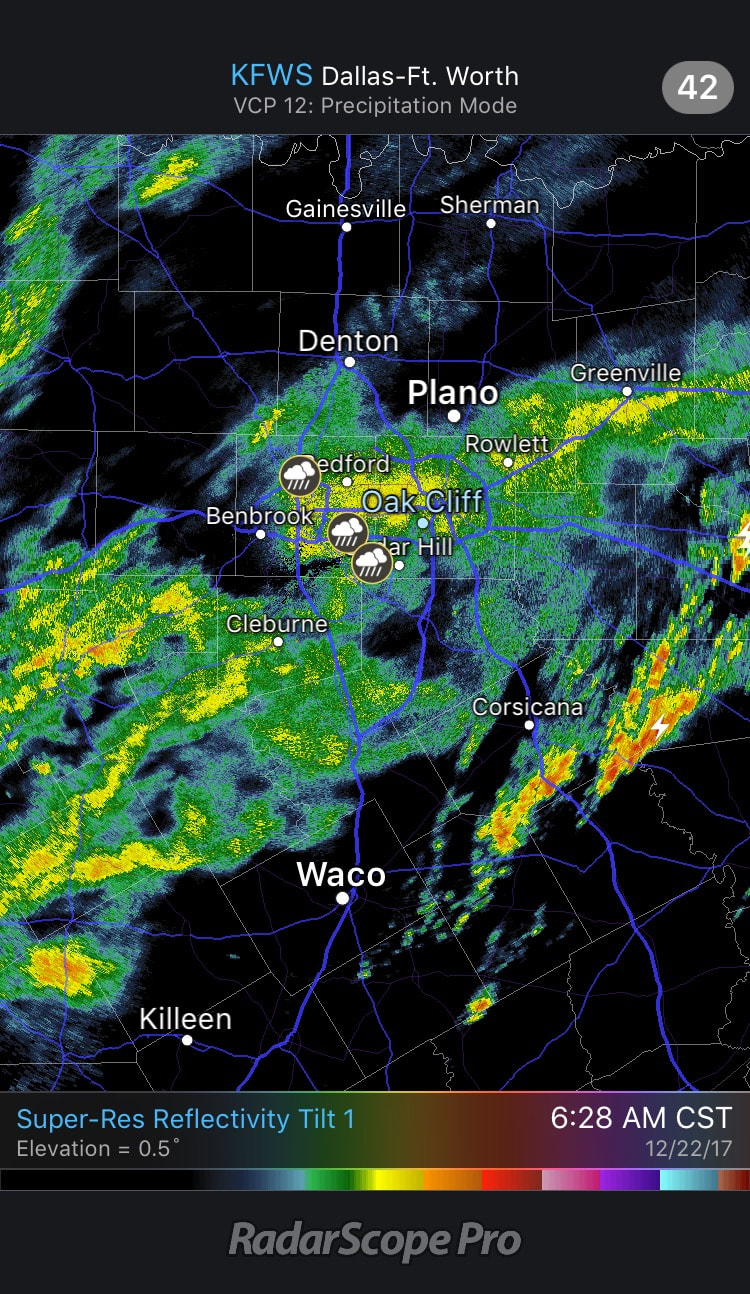 This is caused by an upper trough lifting out of the Southwest US, which will bring plenty of rainfall to North Texas throughout the day. Rain amounts should stay in the one inch range in most spots. Some thunder will remain possible, but organized severe weather should not be an issue. This system will also bring more rainfall to other parts of the Deep South over the next 36 hours, where a flash flood watch is in place for a far east Texas, much of Central and Southern Arkansas, parts of Tennessee, and far North Mississippi, where rain amounts up to 3 and a half inches is possible inside the warned area. 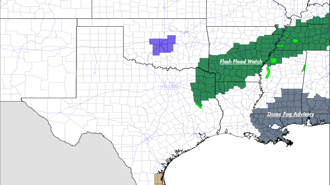 Temperatures are already starting to go the wrong way this morning. Many communities started in the mid 50s this morning, temperatures are already starting to fall to the upper 40s in most spots, and will continue to fall to the low 40s this afternoon and evening. Saturday and Christmas Eve looks cold and dry with highs in the 45-50 degree range. Christmas Day - Sunny and cold conditions will continue to prevail for North Texas on Monday; We start the day in the low to mid 30s, and the high should be in the low 50s during the peak of the day, right at average temperatures for December 25. Rest of the Week Ahead - The weather will continue to be dry Tuesday and Wednesday, then we introduce a chance of showers and rain during the later half of the week. Past that, models tend to agree on colder conditions around New Years, but they continue to have huge discrepancies with the idea of snow at around the same time.  Another Foggy Start - For the third time this week, many North Texans are waking up to mostly misty and foggy conditions, where a Dense Fog Advisory continues to remain in effect this morning until 10AM. Visibility of less than 1/4 of a mile is likely within the warned area, so be sure to once again exercise caution as you travel to work and school. Otherwise, many of us are starting the day in the mid 50s around the metro. After the fog thins out, and the morning hours pass, we should start to see mostly sunny skies with highs in the low 60s across the board. Not much change in tomorrow's forecast; we continue to remain dry with a mix of sun and clouds with near-record highs possible. We should be in the mid 70s by the peak of the day, Midwest Group - I am actually writing this blog update in a hotel room with two people sleeping behind me in Chicago, Illinois, where the Summit High School Wind Symphony will perform at the 71st annual Midwest Band and Orchestra Clinic and Convention. Please make sure to bundle up and dress WARM this morning as temperatures will likely be in the low 30s by the time most of you wake up (yes, I know most of you are still asleep as I'm writing this). Be sure that you stay warm throughout the day as highs will only reach the upper 30s to low 40s in most spots. A mix of sun and clouds is likely throughout the day. More specifics about the weather for tomorrow and Friday will come later. Friday - In North Texas, an arctic front will push through the area, resulting in cooler temperatures and more rain chances on Friday. By noon, most of the rain mass should be in the North Texas area. Some embedded thunderstorms will be possible, but organized severe weather should not be an issue. Rain amounts should generally stay in the one inch range. The Weekend - Saturday and Christmas Eve look very overcast and dry. We will start the day in the low to mid 20s, but we only peak at mid 40s on Saturday, and mid 30s on Sunday. Christmas Day - We are finally starting to get in good agreement in terms of the models. Both the GFS and the European (ECMWF) models continue to show a dry Christmas Day for North Texas with plentiful sunshine along with highs in the low 40s. Since this is still five days out, this could of course change, but right now, the chances of a "White Christmas" in North Texas are very low at this present time.  Rest of Next Week - During the latter half of next week, another disturbance comes from the northwest, and we should see more chances for showers and storms starting Wednesday. To the north of us, winter precipitation will be possible, but for North Texas, just rain for now. The cold weather will still stick around. See the Texas Weather Discussion Video for more details. 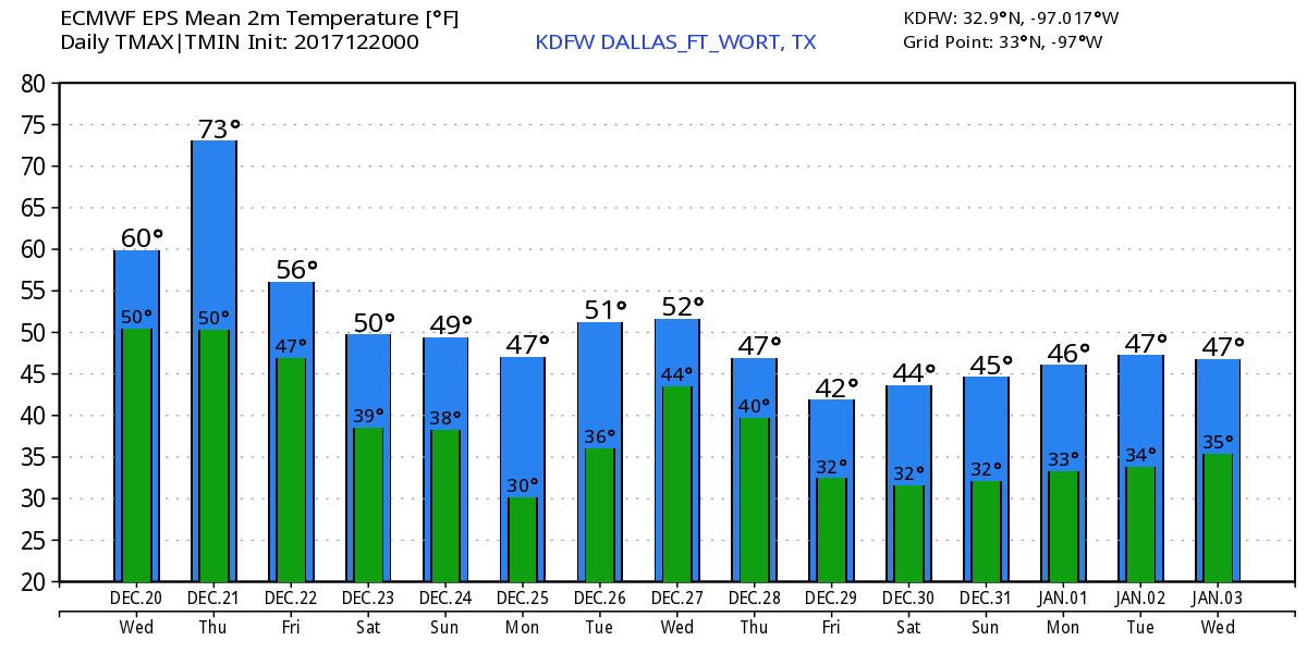 Foggy Start - As you head out this morning, you're probably going to run into problems seeing clearly as you head to work and school. Yeah, there's a lot of fog in the air right now. In fact, a Dense Fog Advisory remains in effect for all of North Texas until 11PM this morning. Be sure to exercise caution when traveling on roadways.  Today, the sun won't show much, and we generally stay overcast throughout with afternoon highs in the low 60s. Tuesday - With a deep surface low developing and a warm front lifting up from the south, North Texas should be in for another around of scattered/numerous showers and storms during the day. A 12-hour window frame of when rain will most likely start and end would be at around 7 AM to 7 PM. Of course, some thunderstorms will be possible, but no organized severe weather is expected. We warm to the low 60s during the afternoon. Midweek - After the rain comes through, we should be considerably drier the next day with the sunshine and with afternoon highs in the upper 60s, seasonably warm for this time of the year. We peak on Thursday in terms of the warming trend, and we forecast highs in the mid 70s during the late afternoon hours. Friday and the Holiday Weekend - Another surface front pushes through Friday morning, which will bring another chance of scattered showers and storms on Friday. For now, the holiday weekend looks mostly dry and overcast with highs in the 50 degree range. The low on Sunday will be in the upper 20s. Christmas Day - For now, global models are leaning more towards the idea that much of North Texas will stay dry for Christmas 2017. Not enough confidence to take rain and some snow showers completely out of the forecast yet, but for now, it looks like we generally stay dry with that new surge of cold air coming through. Afternoon highs will only reach the upper 30s. We start present-opening in the mid 20s. Next Week and Beyond - The rest of next week looks dry and cold with highs in the upper 30s to low 40s. Overnight lows will continue to be in the low 30s. The global models also trend towards winter precipitation later this month into the beginning of 2018. Still early for a specific forecast, but don't get your hopes up for a White Christmas. See the Texas Weather Discussion Video for more details. 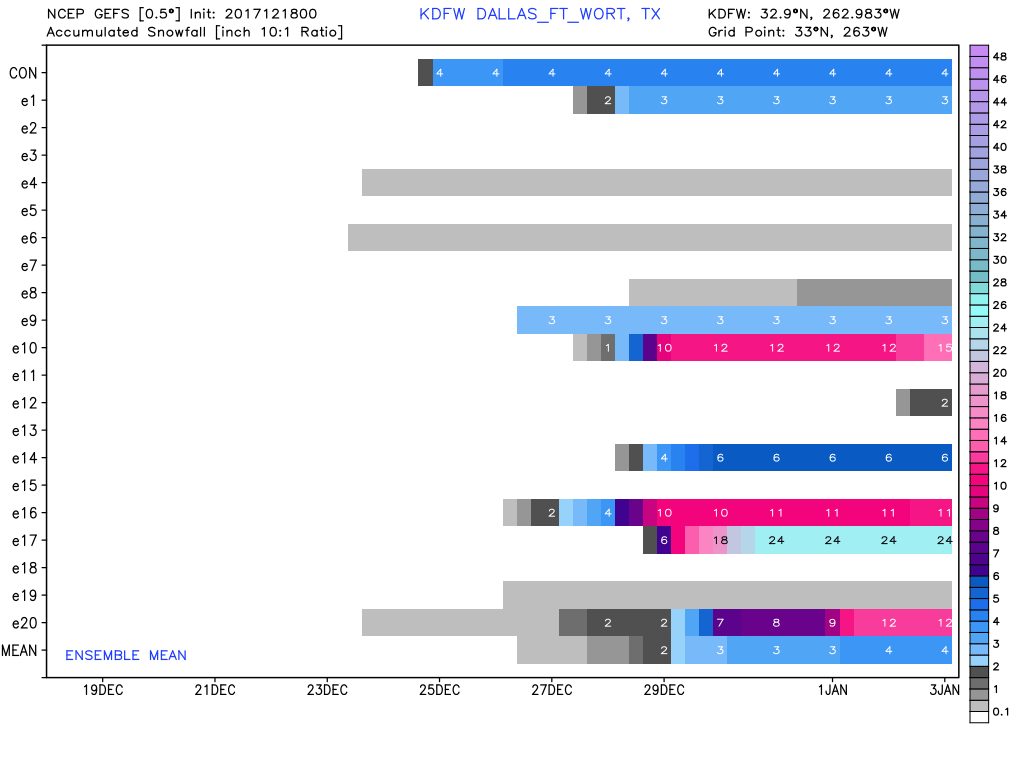  Dry Airmass Through Saturday Evening - Temperatures are mostly in the mid to upper 30s this morning across much of North Texas, some of the colder spots in the western counties are in the upper 20s. Today will be another one of those dry days with highs in the mid 50s, which is actually below seasonal averages for mid-December. Expect a great supply of sunshine today. The Weekend - Saturday morning will still be chilly with most communities starting in the low 40s, then we should warm to the low 60s with abundant sunshine during the afternoon hours. Clouds will start to move in Saturday morning, then rain should begin during the late Saturday night hours or near midnight as a shortwave trough approaches from the west. Any lingering showers will most likely be Sunday morning, but we should be clear for most of the day, and highs should be in the mid 60s. Next Week - Next week looks generally dry with cool nights and pleasant days; highs should average to about the mid 60s with lows mostly in the low 40s. The strongest cold front of the season moves in Thursday evening, which should drop temperatures considerably and maybe even create chances for winter precipitation during the weekend. Still way too early for a specific forecast on that, but just an idea. As we get closer, we dive even more into model madness with this event. 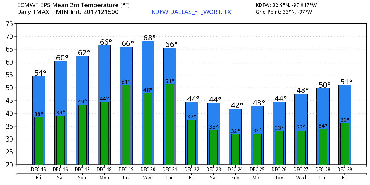 Christmas - Still way too early for a specific forecast, but confidence is increasing that we could see some snow before Christmas. A White Christmas in some spots is still not out of the question though, but we dive more into the model madness the closer we get to the event. We will have the first real look at the situation this Monday. See the Texas Weather Discussion Video for more details. 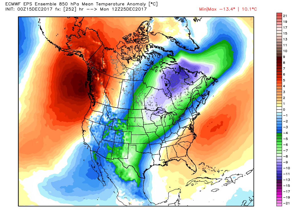 Chilly Start - Another chilly start to the day in North Texas where in Denton, our weather station reports a temperature of 33 degrees as of 5:36 AM. Other locations other than the north are in the 40s. Today will be sunny with a high in the low 60s this afternoon, tomorrow we continue to remain dry with highs in the mid 50s with plenty of sunshine. The Weekend - We begin the weekend on Saturday pretty chilly with lows in the low 40s, then with highs reaching the low 60s with abundant sunshine during the day. Clouds will start to increase during the evening on Saturday ahead of a surface front, then Saturday night through Sunday morning could be wet at times with a few showers or even a thunderstorm as a surface front pushes through and a shortwave trough ejects from the west. Some thunder is possible, but no organized severe weather is expected. And we will certainly take any rain that we can catch right now because many locations around North Texas are entering their 53rd day of no measureable rainfall. Rain amounts will try to amount to 1/2 an inch in most spots. The high should be in the mid 60s on Sunday. Next Week - The early part of next week looks very dry and seasonably warm. The same forecast of cool nights and pleasant days sticks with us for a while. Models do hint at some rain returning late next week... See the Texas Weather Discussion Video for more details. 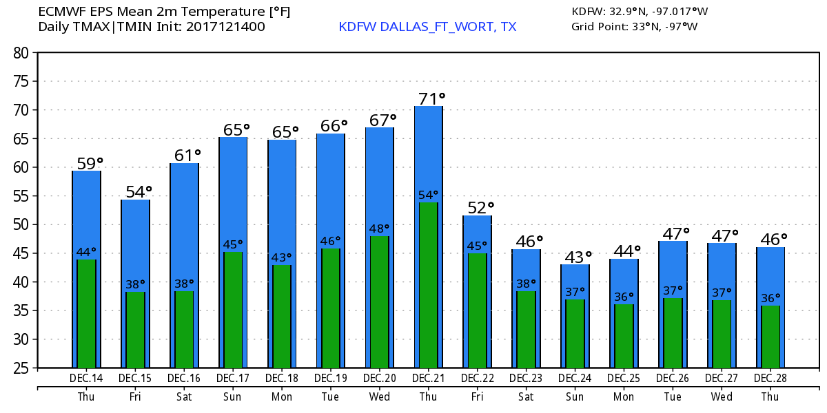 Thoughts on a White Christmas - Lets not get ahead of ourselves, now. Global models have been trending towards some kind of winter weather at or around Christmas day. We could also have a wet down during the week of Christmas, something that we desperately need. Some wintery weather is possible alongside the precipitation. 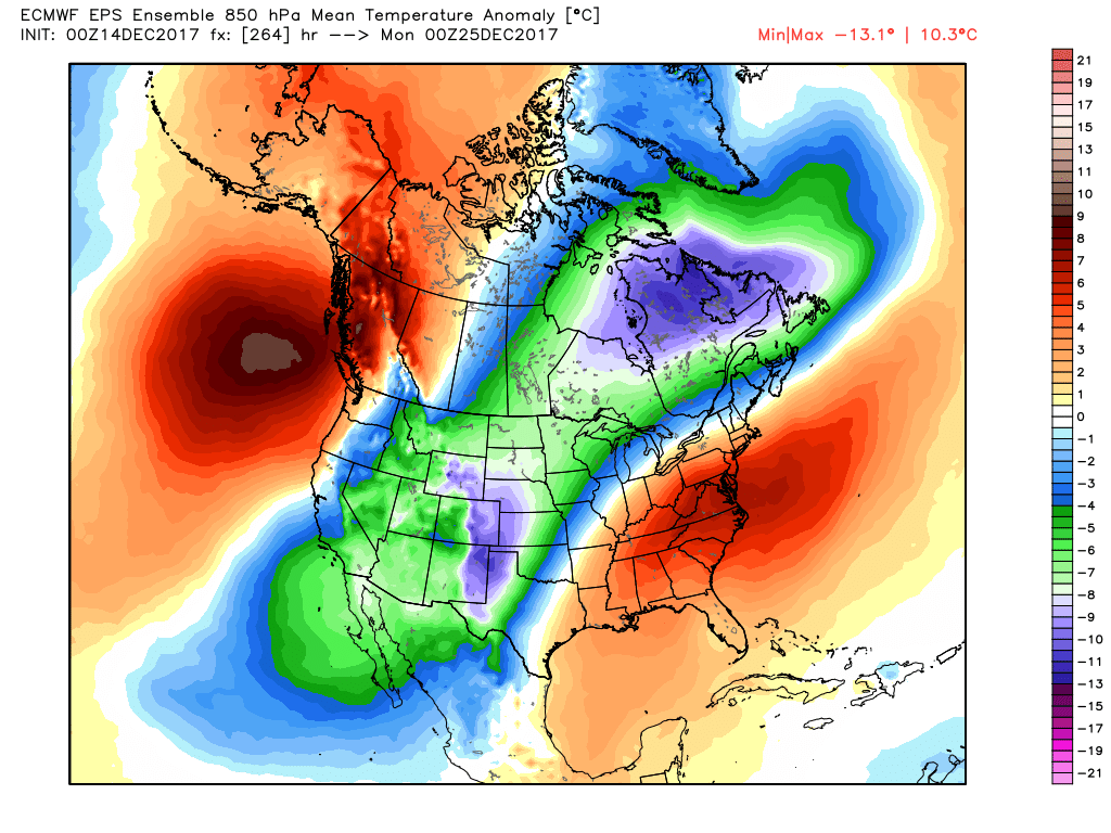 Dry Airmass - A very dry pattern persists for North Texas through the first half of the weekend. We only warmed to the low 60s yesterday, today we will be 10 degrees warmer. Today's high should be around 70-73 degrees. Today will also be relatively breezy with winds speeds in the 10-12 mph range. Due to the drought, almost two months of no measurable precipitation in some spots, low humidity, and above average temperatures in some spots, fire weather conditions are starting to become a concern. Elevated to near Critical fire weather conditions will persist today. There is no red flag warning in effect for North Texas, but be sure to check with your county for any local burn bans. Tomorrow morning will also be cold as temperatures drop to the mid 30s. Friday and the Weekend - Mostly pleasant days, clear, cool nights with highs in the low 60s and lows in the low 40s. We will see abundant sunshine in full force on Friday and Saturday. Clouds begin to increase during the weekend, and we will mention a chance of rain Saturday night into Saturday morning ahead of a passing surface front. We do note that there are model discrepancies in this solution, so the confidence in the amount of rain and timing is pretty low at this time. Otherwise, expect highs in the low 60s on Sunday. Next Week - The dry weather pattern persists for North Texas, and for now, no issues with any major weather event here in the Deep South... 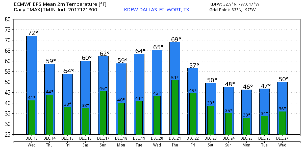 Christmas Snow?? - Although models have been trending towards a white Christmas in North Texas, there is simply no skill in forecasting the weather past ten days. However, we can take analog data that we have (sampling atmospheric conditions and comparing them to past weather events) and come to the conclusion that our chances of a White Christmas is low, but not zero. 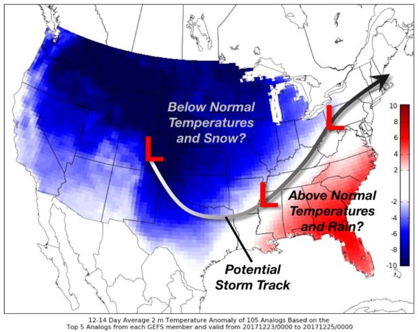 However, we remind you that this is still nothing but an educated guess. We will have a first peek of what Christmas may look like on December 18. See the Texas Weather Discussion Video for more details.
Chilly Start - Temperatures are actually not that bad this morning. Mostly mid to upper 40s across the board. After dealing with near record highs yesterday afternoon, today should be considerably cooler with temperatures in the upper 50s to low 60s due to the cold front that came through during the evening hours. The average high for DFW on December 12 is 58. For the Rest of the Week - Tomorrow should continue to stay nice and pleasant with highs in the low 70s, about ten degrees above average for December. The rest of the week looks to be very dry with cool nights and pleasant days. Another cold front comes through during the day on Thursday, which will cause temperatures to drop to near 60 for that day, followed by mid 50s on Friday. The Weekend - Saturday looks to be a very pleasant day with plenty of sunshine. After starting the morning in the mid 40s, we warm nicely to the low 70s. Moisture will start to increase on Sunday ahead of another cold front, and with that, we will mention a chance of scattered showers during the day on Sunday. However, the European (ECMWF) model shows most of the rain developing to the east of North Texas, showing that we continue to stay dry, which brings the confidence in the forecast down. The high will be near 70 degrees. Next Week - Anything left from Sunday should be out of here by Monday. The high should be around 75 degrees. The rest of the week looks seasonably warm with above average temperatures. Voodoo - Five of the twenty members of the GFS Ensemble show very little hope of snow at or around Christmas, but the other fifteen show nothing. Still way too early in the game to know, and based on climatology, the chances of a White Christmas in DFW is less than one percent... so I wouldn't hold my breath on that. 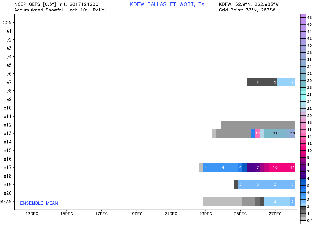 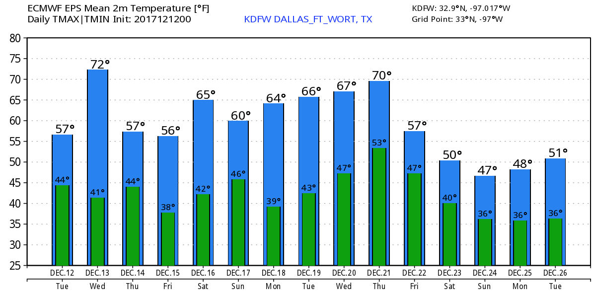 Another Chilly One - Similar to last week, we start the day with temperatures in the 30 to 50 degree range this morning. Today should be a pleasant start to the week with abundant sunshine with highs in the mid 70s. A cold front comes through during the overnight hours, which will make Tuesday a cooler day with highs in the upper 50s. Still plenty of sunshine though. Wednesday through Friday - Not much change. We continue to stay dry and sunny with chilly nights and pleasant days. We forecast a high temperature in the low 70s on Wednesday, falling into the low 60s on Thursday and Friday. The Weekend - Same consistent weather continues this weekend; sunny and dry with highs in the low 70s and lows in the mid 40s. Next Week - The early part of next week looks to be similar to this week; cool nights and pleasant days. We will generally forecast highs in the low 70s to mid 60s for the early part of next week. A cold front comes through by Monday, and it remains unknown if we get rain during the early part of next week. See the Texas Weather Discussion Video for more details. 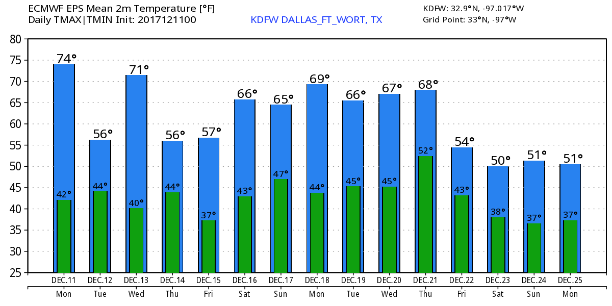 Hard Freeze - A hard freeze is underway for many North Texans early this morning. Here are some of the temperatures as you head to work and school... DFW - 29 Arlington - 25 Burleson - 23 Cleburne - 21 Waxahachie - 25 Denton - 19 McKinney - 21 Mineral Wells - 20 Gainsville - 16 Bowie - 19 Graham - 12 Hopefully you prepared for this by protecting sensitive plants and animals, turning off sprinklers, bringing your dogs in for the night, and more importantly, protecting yourself with the proper clothing. The good news is, today shouldn't feel as brutally cold as yesterday as the wind chill will not interfere with the actual temperature today. Plan for a very cool day with highs reaching the upper 40s to low 50s today and abundant sunshine. Across The Region - Many locations across the Deep South currently have ongoing winter weather one way or another. Either by expected snow accumulation or a very hard freeze. Either way, it is a very cold sight across the Deep South this morning.  Some places in Southern and central Texas had accumulating snow. Places like San Antonio, Houston, and College Station turned into a winter wonderland yesterday evening! 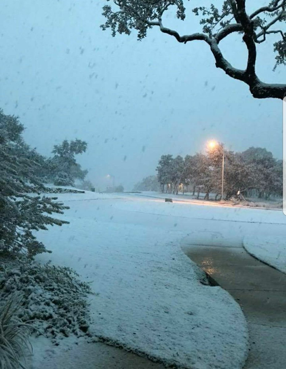 Football Weather - For the high schools continuing in their fourth round of playoff games today, the games should be played under a clear sky with temperatures falling from the upper 30s. Lake Ridge High School takes on Highland Park tonight at AT&T Stadium (kickoff @ 7:30p). The game should be played with temperatures around 37 degrees at kickoff, falling to around 35 by the final whistle. Legacy High School takes on Lone Star tonight at SMU's Ford Stadium (kickoff @ 2:00p). For now, the game looks to be played under a sunny sky with the temperature around 45 at kickoff, increasing a degree or two by the end of the fourth quarter. The Weekend - As we go through the weekend, we begin a warming trend. Abundant sunshine will still be in place, but afternoon highs will range from around 55-65. The overnight lows should be in the 35-40 degree range. Next Week - Another cold front comes by after Monday, which should bring temperatures down to the mid 60s. Otherwise, most of next week looks seasonably warm with above average temperatures. See the Texas Weather Discussion Video for more details. 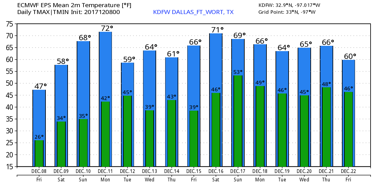 Radar Check - Very light rainfall continues over parts of Central Texas this morning. Some of the rain is not even hitting the ground at this point... 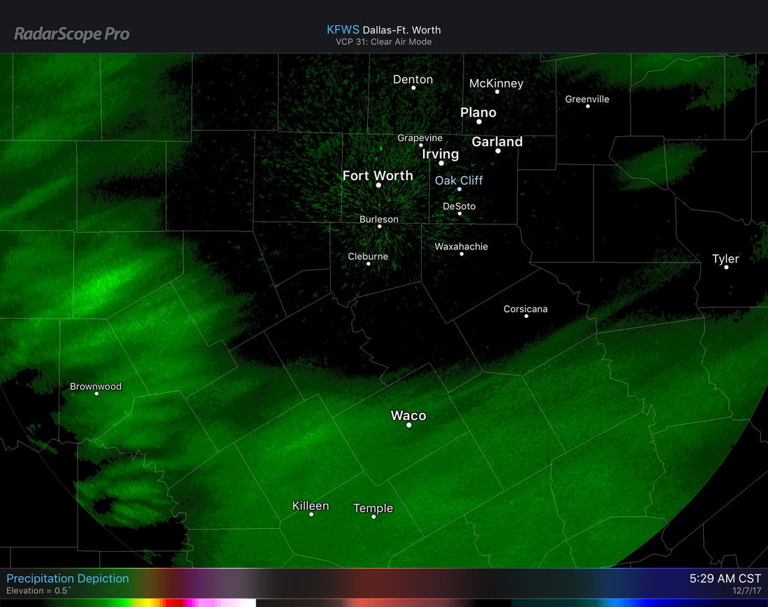 There is still the chance that some of the rain could turn into a sleet/snow mix. But no accumulation or impacts is expected at this time. Most communities in and around the DFW metro are in the mid 40s this morning. If it is cold now, it will only get colder as we progress through the day. With a cold trough in our area, a cold front passing through this afternoon, and a northwest wind at 10-15 mph, high temperatures will fall to the lower 40s this afternoon. The wind chill associated with the northwest wind will actually make it feel like the low 30s/upper 20s, making for a raw, cold day. Be sure to dress accordingly this morning and plan ahead for the rest of the day. 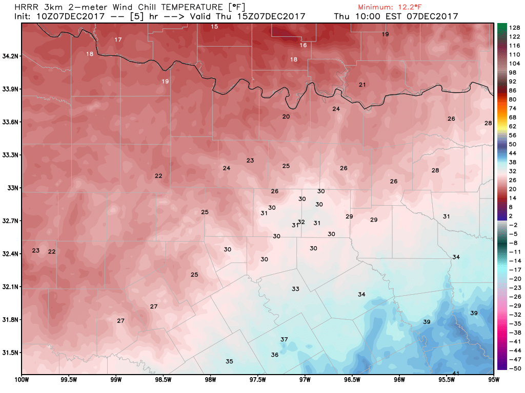 During the overnight hours, the temperature will drop significantly to the upper 20s during the overnight hours, which means that we will most likely see our first freeze of the season in North Texas. A Freeze Warning will most likely be required for the DFW metro area and much of north-central Texas this evening for the possibility of a widespread freeze tonight into Friday morning. After the morning hours, Friday will also be another chilly day with highs only reaching the upper 40s in most spots. The sun comes out by the afternoon, which won't help much with our cold situation. Football Weather - For the high school playoff games tomorrow night, the game should be played under a mostly fair sky with temperatures falling from the mid to upper 40s during the game. Lake Ridge High School will take on Highland Park at AT&T Stadium Friday night (kickoff @ 7:30p). The weather going into the dome looks very cold with a temperature around 48 at kickoff, falling to around 43 by the final whistle. The Weekend - We trend warmer and sunnier through the weekend, and we will forecast highs in the 60-68 degree range with lows in the upper 30s. Next Week - The upper-level trough should continue to be anchored over the eastern thirds of the U.S., and the week ahead looks very dry with temperatures generally below average. See the Texas Weather Discussion Video for more details. 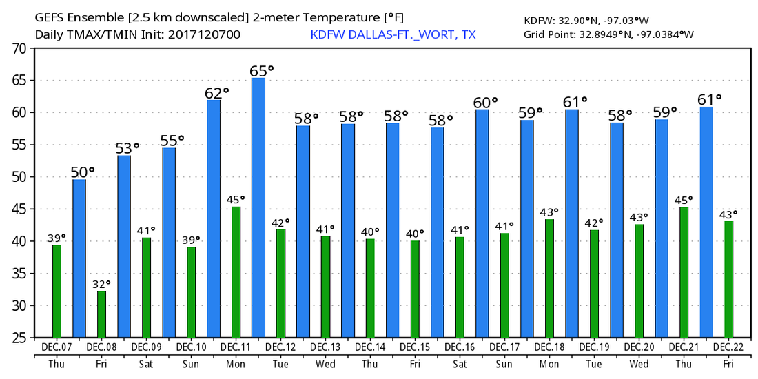 Radar Check - Most of the light rain is now mainly to the south of I-20 this morning, and is generally spreading to the east. 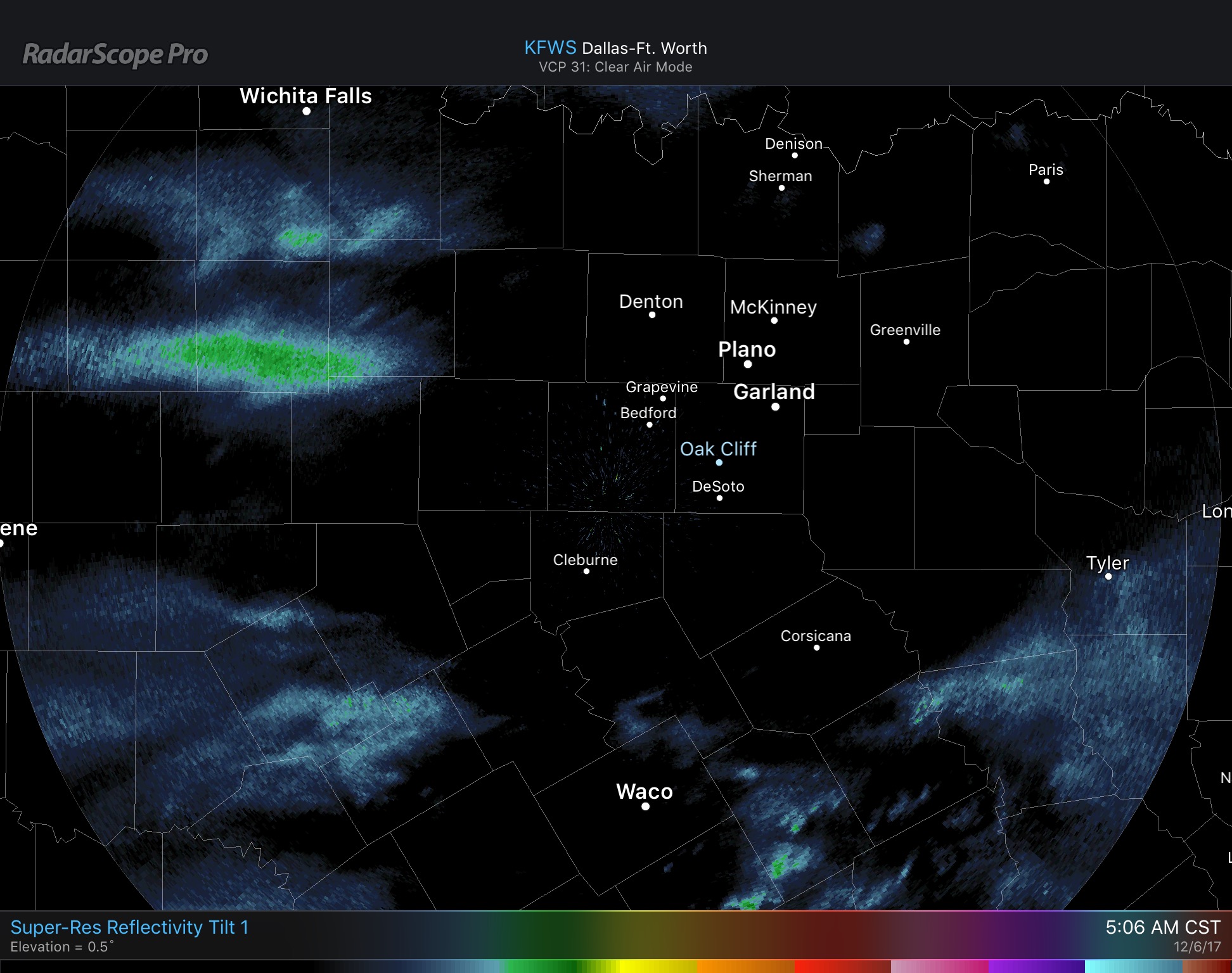 There is still a chance that some of the rain could turn into sleet pellets, but the chances are still more likely to be confined to the west of I-35 this morning, where temperatures near the upper 30s in those spots.
In DFW, it will still very chilly as you head out this morning with temperatures in the mid 40s. And it won't get that much better as we progress through the day. Temperatures in North Texas are only expected to warm to the low 50s, about 10-14 degrees below average. Widespread overcast conditions will continue to prevail today. Thursday - Not much change. It will still feel cold and raw throughout the day, with highs only reaching the mid 40s. Be sure to dress appropriately for the coldest day of the season thus far. Cloudy conditions will also continue on Thursday. Friday - The first widespread freeze of the season takes place early Friday morning past midnight, where temperatures fall into the upper 20s in most spots. However, the sun should come back out during the afternoon, and temperatures will reach the mid 50s during the peak of the day. Football Weather - For the high school playoff games still taking place in North Texas, the weather will be relatively cold with temperatures falling from the low 50s during the game. Lake Ridge High School takes on Highland Park at AT&T Stadium this Friday (kickoff @ 7:30p). For the weather going inside the dome, it will be cold with temperatures at around 52 by kickoff, falling to 49 by the final whistle. The Weekend - Not much change in the forecast during the weekend; we continue to remain mostly sunny and dry with highs in the 60-65 degree range. Next Week - We remain slightly above average for the next 7 days, next week looks pretty dry with highs generally in the mid 60s. See the Texas Weather Discussion Video for more details. December Chill - We start the morning in the mid to upper 50s in most communities. We will actually drop to the upper 40s as we progress through mid morning, then we should warm to the lower 50s as we get closer to the afternoon. It should stay mostly cloudy throughout the day, and highs should generally stay below 55. The average high for DFW on December 5 is 60 degrees. Another disturbance rolls in here during the overnight hours, and widespread showers will be possible beginning just before midnight. Rain should stay light, and rain amounts should stay generally below .10 of an inch. Rain could linger into the morning on Wednesday, but should clear during the afternoon, and we should stay in the low 50s for highs. Thursday and Friday - After the disturbances pushes through, we remain mostly sunny with highs in the low 50s on Thursday, warming up to near 60 by Friday. Areas of frost is possible on both days, with overnight lows in the 30-40 degree range. The Weekend - Not much change. We will continue on a warming trend leading up to Sunday. Both days should be sunny with highs in the 60-65 degree range. Lows will generally stay in the low 40s. Next Week - This pattern favors average temperatures with drier than normal conditions. Most of next week looks very dry with temperatures above average for December. See the Texas Weather Discussion Video for more details.  Another Chilly Start - We start the day with most locations in the mid 40s/low 50s in North Texas. We could see a few broken clouds starting off, but we should quickly warm to the low 70s this afternoon with abundant sunshine. The Weekend - The weather will continue to be dry on both days with abundant sunshine, mild afternoons and cool nights. Highs will be in the 72-79 degree range on both days with lows generally in the 50s. Football Weather - For the high school playoff games tonight, the weather should continue to remain quiet and dry with temperatures falling through the 60s. Summit High School takes on Highland Park at SMU in Dallas (7:30p kickoff)... For now, we continue to forecast a few clouds in the night sky with temperatures falling from 64 at kickoff to about 60 degrees by the final whistle. No rain expected during the game. Pattern Change Next Week - Rain chances begin as soon as Monday of next week with an arctic front passing through. Rain would be possible on Monday through Tuesday morning. As the cold front pushes off to the east, severe weather does not appear likely, but rain amounts generally stay below a quarter of an inch. Then, a deep upper-level trough progresses through the central and eastern thirds of the nation, and we continue to forecast the coldest air thus far in the season with lows potentially reaching the low to mid 30s and highs in the low 50s. And the medium range global models suggest that the pattern change could stay in place through mid December, and potentially through the rest of the month. Way too early for a specific forecast, but just an idea. See the Texas Weather Discussion Video for more details. 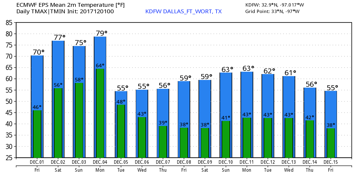 Happy Meteorological Winter! - Today marks the first day of 2017 Meteorological Winter. However, astrological winter begins on December 21 this year. Good news is - colder air is on the way to get us into the holiday feels.
|
Archives
April 2024
Categories |
 RSS Feed