
|
Cool Start - Temperatures on this Halloween morning are actually very similar to yesterday's lows; most locations start out in the 50s, with some of the naturally cooler spots in the 40s. As a result of the cold front that came through yesterday afternoon, we should experience much cooler highs with the temperature only warming 6 to 8 degrees today. A cool day is in place. In addition to the cool air, scattered showers and storms will be possible during the afternoon/evening hours. Most models have the idea that the bulk of the rain will enter DFW at around 4:00, before exiting the area after 7:00. Model guidance also back off the amount of rain associated with this feature, but, you will still need to bring an umbrella just in case anything decides to stick out after the bulk has passed. Tomorrow through Friday - After Wednesday, we start the rapid increase in temperatures with highs ranging from 83-89 degrees. All of us should stay dry from any rainfall, which should also be perfect for the high school football games. The Weekend - Not much change; we maintain fairly consistent weather with cloudy period along with highs in the mid 80s. Most communities in DFW stay dry. Next Week - Another cold front comes through early next week, which will bring the chances for cooler temperatures and scattered showers and storms. More details we get closer. 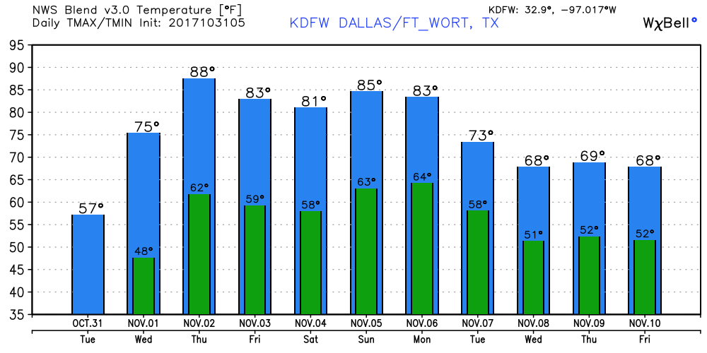 Tropics - The disturbance located in the Central Atlantic is not expected to develop due to strong winds and shear. The rest of the Atlantic Basin remains quiet. Keep in mind that hurricane season runs all the way through November 31. We also begin our late severe weather season tomorrow. See the Texas Weather Discussion Video for more details.
Air You Can Wear - A cool, but comfortable morning is in store for those traveling to work and school; temperatures are mostly around the upper 40s and low 50s. We should only warm to the mid 70s in most spots today with abundant sunshine. A cold front will come through later today which will set the stage for a much cooler day along with rain chances tomorrow. Highs mostly in the mid 50s on Tuesday, with the chance for scattered showers and storms during the late afternoon and evening hours. Trick-Or-Treat? - We do think that most of the rain will come when it is time to go hunting for candy. The latest run of the North American Model (NAM) currently shows the likely time of showers and storms to be 3PM - 8PM. If you still plan on going trick-or-treating, make sure you plan ahead and bring umbrellas and jackets just in case something decides to pop out after sunset. Otherwise, the high for Halloween will be in the mid 50s. Wednesday Through Friday - We start November warm and dry with highs mostly in the 80 degree range with abundant sunshine. No signs of any precipitation at this point. The Weekend - Not much change. Warm, but comfortable weather in store for the weekend, with highs in the 80-84 degree range with clouds out at times. Next Week - After Monday, temperatures cool down to the low 70s to upper 60s, adding a chance of showers early next week, but no signs of any widespread rain anytime soon. 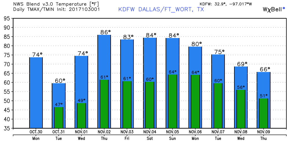 Tropics - The disturbance that was known as the remnants of Phillipe is now a Nor'easter in the northeast, bringing heavy rain and floods to that part of the region.
There is another wave that currently has a medium chance of developing during the next five days. If anything decides to surprise us, it should just meander over the Central Atlantic, posing no threat to the U.S. The rest of the Atlantic basin, is quiet. See the Texas Weather Discussion Video for more details. Air You Can Wear - Temperatures this morning as you wake up and start your morning commute... DFW - 54 Arlington - 52 Love Field - 62 Denton - 55 Weatherford - 56 Burleson - 54 Cleburne - 54 Today will be the hottest its been in recent days with most locations reaching the upper 80s this afternoon; about 13 degrees above average for October 26. Tomorrow - A cold front will come through later today, which will set the stage for a very chilly day on Friday. We start the day out in the mid 30s, meaning some places in North Texas will probably see their first frost of the season. Some of the naturally cooler pockets will see their first freeze of the season. (Be sure that you plan ahead for this because this may kill many crops, ending the growing season.) Additionally, sustained winds of 25 mph is likely with gusts up to 40 mph. A Wind Advisory will go in effect today at 9 PM this evening until 10 AM Friday morning. We will mention the chance of an isolated shower or two during the day. The Weekend - Saturday should be very similar to Friday; lows in the mid 30s, only warming up to the upper 50s during the afternoon hours. A frost/freeze is more likely on Saturday due to the calmer winds during the night. Abundant sunshine is still in full swing though, and we should continue to remain dry. Sunday should be a significantly warmer day starting out with temperatures near 48, warming to near 60 by the peak of the day. Football Weather - For the high school football games tomorrow night, I do think that most, if not all of the rain should be out of here by this late afternoon. Most stadiums will be dry. The sky will be cloudy with temperatures falling from the mid 50s at kickoff to upper 40s by the final whistle. Summit High School hosts Midlothian at R.L. Anderson Stadium for its homecoming game (kickoff @ 7:30p). Things should remain quiet and dry with temperatures falling from near 53 at kickoff to 48 by the end of the fourth quarter. Next Week - Monday will be another dry day. By Tuesday, another cold front will come through, which will bring more chances of showers and storms throughout the day on Tuesday. The rest of the week looks dry with highs generally staying in the 70s. 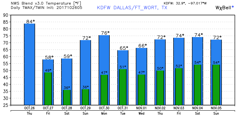 Tropics - A disturbance that is located in the northern Caribbean has a medium chance of developing during the next five days. It should travel northeast along the cold front this weekend, skirting the U.S East Coast. If anything, heavy rain will be possible with the system. The rest of the Atlantic Basin remains quiet. See the Texas Weather Discussion Video for more details.
Cool October Morning - Hmm... The temperature this morning seems to be just right; 56 at Arlington and DFW at 5:32. Not too cold or hot, but you may want to bring a light jacket this morning if you get cold easily. A cold front that came through Monday evening will leave behind a cool October day with highs only reaching the low 70s to upper 60s, which is still five degrees above average. Tomorrow Out - We still forecast sunny, pleasant days and cool, chilly nights. Highs should generally be in the 70s, with lows in the 50s. Some of the naturally cooler spots may reach the 40s in some spots. The one of the coldest days of the work week should be on Friday, where another cold front comes through by Thursday night, which should drop maximum temperatures to the low 60s and lows in the upper 30s. The Weekend - It looks like that we could very well see our first frost of the season by Saturday morning with lows in the mid to upper 30s with potential for frost in some spots. The average first freeze in Texas is usually November 22, so we are just under a month early for this. It will sure feel more like January instead of October. By Sunday, we should warm a good 10 degrees more which highs in the upper 60s in most spots. Lows should warm to the mid 40s in most spots. Next Week - Although we are STILL about five degrees above in temperatures, we say goodbye to 80 degree weather for a while and hello to a real feel of fall. Highs will remain in the low 70s in most spots with abundant sunshine in full force. 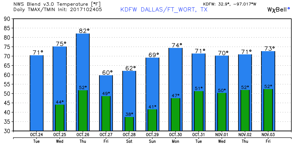 Tropics - The Atlantic Basin is quiet now, but NHC suggests that a wave located in the northern Caribbean has a 50/50 chance of developing during the next five days. If anything does form, it should move on a east/northeast path, and should be a problem to the Gulf of Mexico. See the Texas Weather Discussion Video for more details.
Another Cool Morning - As you head out the door towards work and school, you may want to grab a light jacket. Temperatures will be in the 40s for most spots across the region, but should warm up into the low 80s as we progress throughout the day. Another mild day is in store for us until another cold front arrives this evening which will make tomorrow significantly cooler. Highs will only reach the upper 60s, but the sun should remain in full force for both days. No rainfall is expected for north Texas. Wednesday through Friday - Not much change. We expect a gradual warm up to mild temperatures once again by Thursday, where highs will reach the low 80s. Another cold front arrives Thursday night, which will also result in Friday being much cooler. Afternoon highs should only reach the low 60s with morning lows in the low 40s in most spots. The Weekend - As a result of the cold front moving through on Thursday night, Saturday should be the coldest day of the season thus far with highs only reaching the upper 50s and lows sticking just above the below freezing mark (35 degrees). This is where highs could potentially be 20 degrees below average, which would suggest the first freeze of the season. By Sunday, most clouds clear the region, and temperatures increase to the mid 60s. Cool, refreshing fall weather is in store for us this week. Next Week - After a crazy week of temperature fluctuations, at least the beginning half of next week looks to be dry and stable with highs remaining in the low 70s. 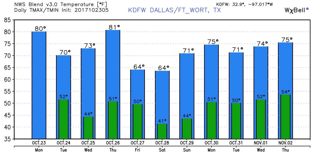 Tropics - A broad area of low pressure that is located in the northwestern Caribbean has a medium chance of developing during the next five days. Details are unclear now, but should become more clear as we progress further. The rest of the Atlantic Basin, is quiet. See the Texas Weather Discussion Video for more details.
Slightly Warmer - Starting out the day, we are slightly warmer than recent days, with temperatures hitting the 60s in most spots. During sunrise, you should see a cloudy sky due to the shortwave trough to the west of the state. It should stay mostly cloudy throughout the day with highs sticking in the low 80s/upper 70s. We will also need to mention the chance of a few showers during the afternoon/evening hours. Saturday - For most of the day on Saturday, we should still be completely dry with the temperature still peaking out near the mid 80s during the late afternoon. After sunset, this is where things get a bit interesting here. Back in west Texas, showers and storms should develop along a cold front and progress to the east, mainly during the overnight hours. This where the SPC has put some spots in north Texas and much of central Oklahoma under the "enhanced" risk of severe storms. 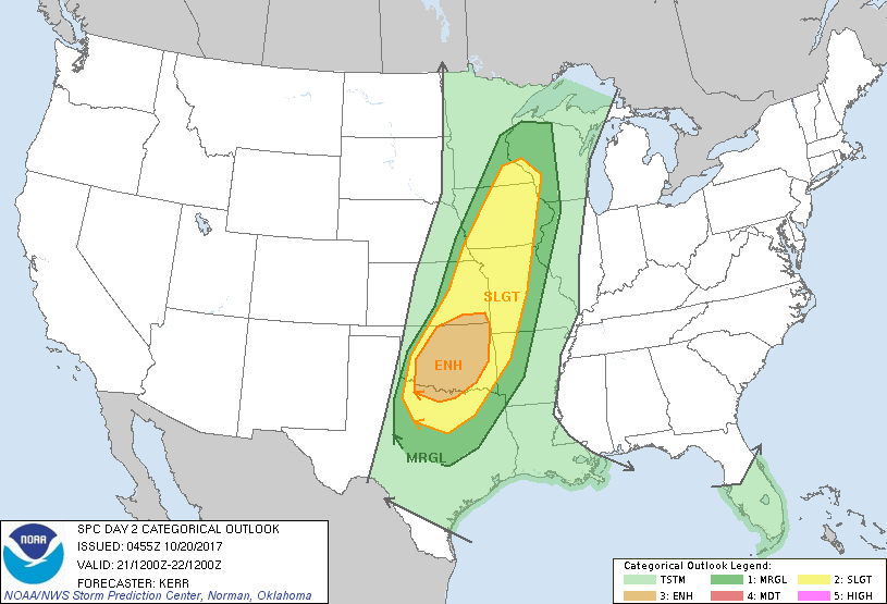 Where we are in DFW, we are still in the standard 'slight' risk for severe storms for Saturday and Sunday. Keep in mind that these outlook run until 7:00 AM the next day. The Setup - A trailing cold front should continue to move to the east. Once it reaches west Texas during the evening hours on Saturday, severe storms should begin to develop. Due to the combination of instability values of 2000-3000 j/kg and some shear of near 30 knots, severe storms capable of producing damaging winds, large hail (some greater than 2" in diameter), and isolated tornadoes will form along the cold front and should move mainly to the east. Most of the development will likely take place in the enhanced risk area, where the area of discrete storms during the early phase is most likely. Where we are, we most likely won't get the squall line until likely past midnight. However, severe weather will still remain a possibility with the threat for mainly damaging winds and some hail. So, for a 12 hour window, the risk for thunderstorms should begin around 9:00 Saturday evening and end at 9:00 Sunday morning. After the storms, the rest of the Sunday looks refreshing and cool with highs in the low 70s. Football Weather - For high school football games tonight, most of the games in North Texas will be played under a cloudy sky; temperatures should fall from the low 70s at kickoff to near the upper 60s by daybreak. Summit High School hits the road once again to take on Red Oak (kickoff @ 7:30p). For now, temperatures should fall from 73 at kickoff to near 68 by the final whistle. We will have to mention a risk of a shower or storm during the game, as the chances will still be possible this afternoon/evening. Next Week - We get rid of 80 degree weather for a while, and 70s and potentially 60s flood the region next week. No sign of any widespread rain event. See the Texas Weather Discussion Video for more details. 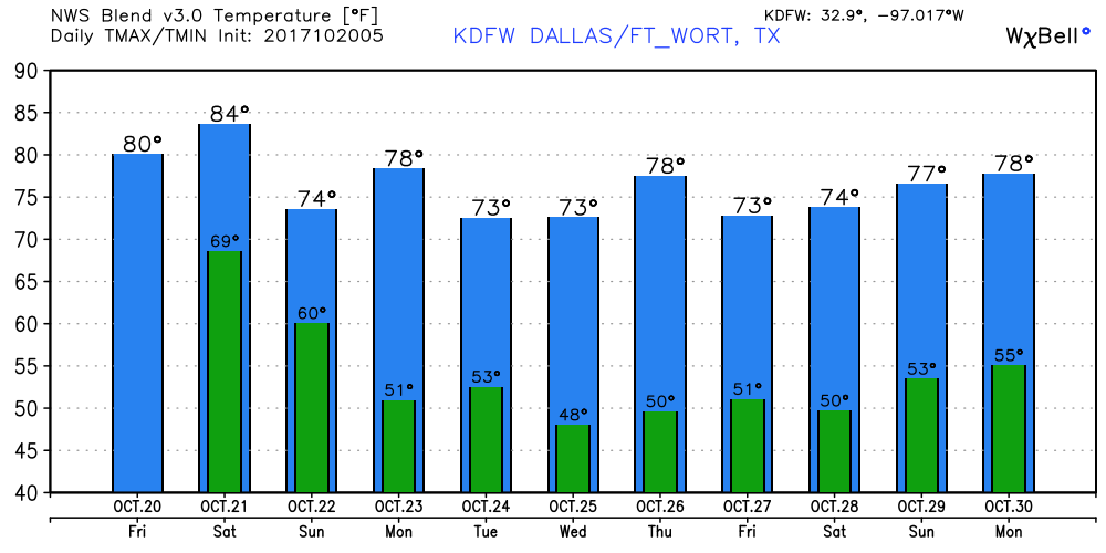 Tropics - The Atlantic Basin remains quiet, and no new tropical cyclones is expected for the next week.
Another Comfortable Morning - Another comfortable morning as we wake up in North Texas; not to hot and not too cold. Arlington, TX reports a temperature of 53 degrees just before sunrise. A light jacket may be needed as you head out the door this morning. Most locations are in the 50s under a clear sky. We expect another cloudless sky today with temperatures reaching the low 80s this afternoon. And no real change on Friday; mostly sunny, pleasant days with cool nights. Highs will remain in the upper 80s on both days with lows in the 60 degree range in most spots. The Weekend - This is where our weather gets a little bit interesting. The cold front arrives Saturday night/early Sunday morning. Along and ahead of that, severe weather remains a possibility for both days, where the SPC has introduced an "enhanced" risk for severe weather in some parts of north Texas. 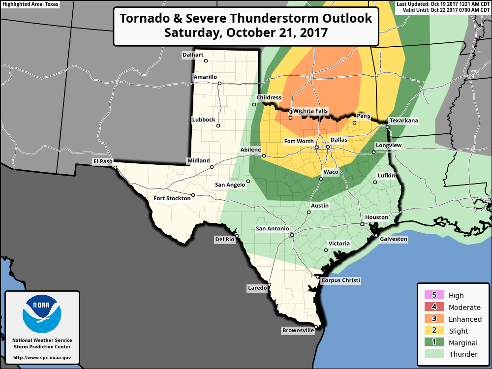 Keep in mind that this outlook for Saturday is valid through 7 AM on Sunday. During Sunday afternoon, a severe squall line will begin to develop in west Texas and make its way east during the overnight hours. Damaging straight-line winds will be the greatest threat, but, a few tornadoes cannot be ruled out. Ultimately, it doesn't matter where you are on this map. If you are under a severe weather risk of any kind, you are still in fair game of getting something. More details to come tomorrow. After the cold front comes through, we are left much cooler with highs in the low 70s. Bring a jacket and a umbrella for the likely wet commute ahead, if anything lingers around. Football Weather - A great night in store for us for high school football games tomorrow night. The temperature will generally fall from the low 80s at kickoff to near the mid 70s by the final whistle. Summit High School hits the road once again to take on Red Oak High School (kickoff @ 7:30p). We will need to mention the slight chance of a shower or two during the game. Otherwise, expect mostly overcast conditions with the temperature falling from 78 at kickoff to near 70 by the end of the fourth quarter. Next Week - Not much change. After the cold front from the weekend, expect mostly sunny and pleasant conditions and cool nights with highs remaining in the low 70s. 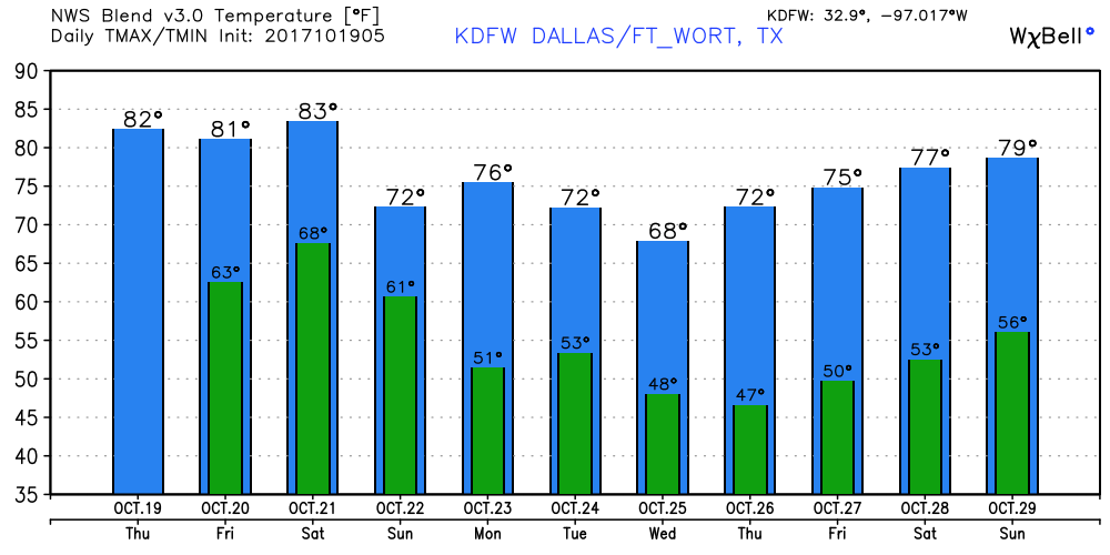 Tropics - The Atlantic Basin remains quiet, and no new tropical storms are expected for the rest of the week. See the Texas Weather Discussion Video for more details.
Still Chilly!! - Here are some of the temperatures this morning... DFW - 53 Fort Worth - 55 Arlington - 45 Dallas Love Field - 56 Waxahachie - 49 Athens - 45 Denton - 50 McKinney - 47 Rockwall - 54 Generally speaking, these are the coolest morning that we have had since early April. Yesterday was the coolest morning we have had since April 6. Going forward, this day will feature more sunshine in full force with highs in the low 80s with low humidity. Tomorrow and Friday - No real change. Mostly sunny and pleasant on both days with clear, cool nights. Highs will be in the low 80s for both days with lows in the 60 degree range. The Weekend - We do note that the SPC has much of North Texas and parts of central Oklahoma under a severe weather risk on Saturday. Ample instability may be enough to kick off some severe storms in the standard "slight" risk area.  It is too early in the game to pinpoint any specific severe weather hazards, but rain amounts of 1 to 1 1/2 inches look possible starting at 6PM Saturday evening until 1 PM Sunday afternoon. Sunday is the day when the cold front arrives, where scattered to perhaps numerous showers and storms will be possible, mainly in the morning hours. The overall high will be at around the mid 80s on Saturday, falling to the low 70s by Sunday. Football Weather - A great night in store for high school football games on Friday; clear skies with temperatures falling from 75 at kickoff to near 70 by the final whistle. Next Week - After this weekend, the rest of the week looks very pleasant with with the sun sticking around along with high temperatures of mid 70s to low 80s. 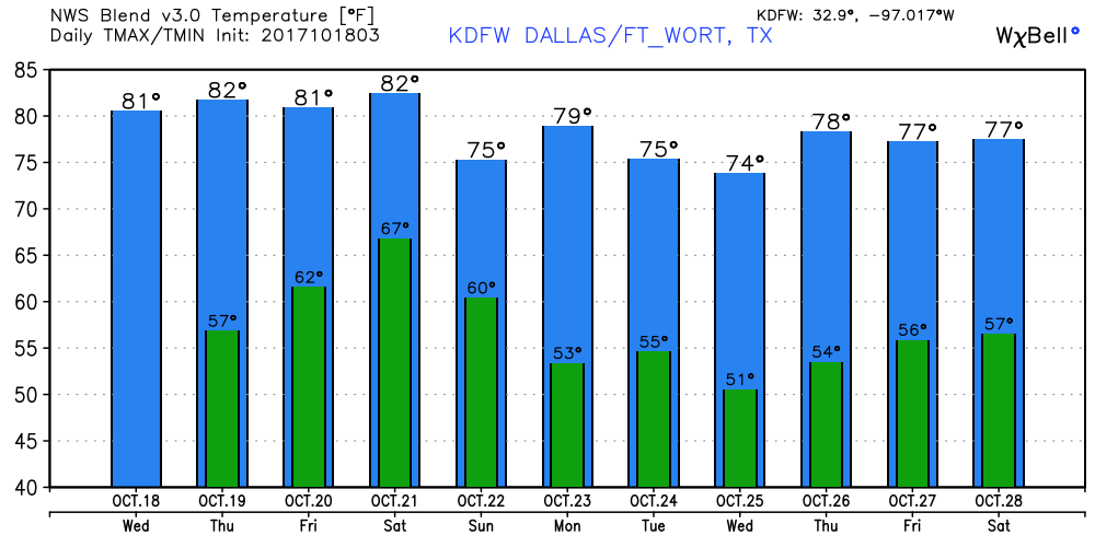 Tropics - The Atlantic Basin remains quiet, and no new tropical cyclones are expected during the next five days. See the Texas Weather Discussion Video for more details.
Fall Weather - The advertised cool change is making most North Texans really happy, even Alaskans. With a very clear sky, temperatures are 5-7 degrees below average with very low humidity levels.  Today will be another picture-perfect fall day, with highs only reaching the mid 70s by daybreak, followed by another chilly night with lows reaching the upper 40s. Tomorrow Out - Picture perfect fall weather will continue with sunny, pleasant days and cool, clear nights ahead. Highs will be in the mid 70s to low 80s with lows in the mid 50s. Really doesn't get any better than this. The Weekend - By Sunday, another cold front drops from the north, which will give us another chance of scattered to numerous showers and storms throughout the region along with more cool temperatures. Global models have been fighting about mostly the timing of the arrival time, but just know that showers and storms will be possible starting Saturday. Next Week - We continue the fall weather with highs in the low 80s with lows in the upper 50s with sunny days and clear, cool nights. 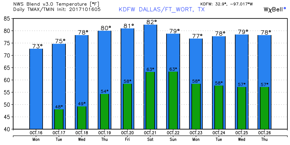 Tropics - The disturbance (Invest 92L) that is east of the Bahamas is not expected to develop due to strong upper-level winds. But, if something does somehow surprise us, it should recurve out to sea, posing no threat to land. The rest of the Atlantic Basin, is quiet. See the Texas Weather Discussion Video for more details.
Fall, Is That You? Finally? - With 90 degree days done and over with (hopefully) for the rest of this year, must cooler air floods the region once again this morning, behind a strong cold front. Most locations surrounding DFW are in the upper 40s, but DFW is no exception to the chilly morning, with a recorded temperature of 50 degrees as of 5:35. A light jacket will be needed as you head out the door this morning, and you may want to just hang on to it for the rest of the day, with temperatures only reaching the mid 70s at most across North Texas. The same weather is in store for us on Tuesday; a chilly morning with a comfortable afternoon in store. Highs will be in the middle 70s once again. Keep that jacket handy for Tuesday as well. Midweek - Not much change, other than a warmer start to the morning. Abundant sunshine sticks with us even on Wednesday, with highs reaching the low 80s in most spots, but no 90 degree weather anywhere. Rainfall is not expected until next week. We still start the day in the mid 50s in most spots. Friday is another pleasant day with a cool start to the morning with highs sticking in the mid 80s, perfect weather for high school football games during the night. The Weekend - Not much change on Saturday. We still stick with mostly sunny weather with highs in the mid 80s with cool nights. By Sunday, another cold front makes its way through North Texas, bring scattered to perhaps numerous showers and storms throughout the day on Sunday. Global models suggests heavy rain in store for some places across the region. Next Week - After the cold front goes through, bringing the chance of scattered/numerous showers and storms throughout the day on Monday, we should be back to 70 degree weather for the early part of next week with clear days and cool nights ahead.  Tropics - Ophelia is now on the northeast corner of the Atlantic Basin, and is continuing to threaten Ireland as a post-tropical cyclone, which should lose its tropical characteristics by Wednesday. Another wave (Invest 92L) that is to the north of the Turks and Caicos Islands have a medium chance of development over the next five days. If anything happens to form, it should recurve into the open Atlantic, posing no threat to the U.S. The rest of the Atlantic Basin, is quiet. See the Texas Weather Discussion Video for more details. 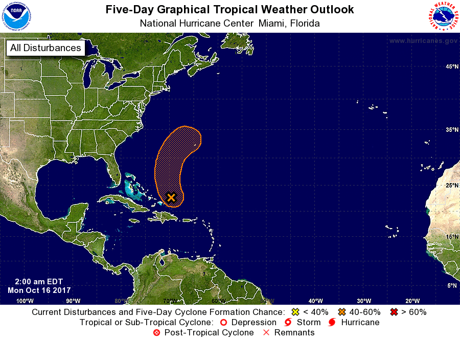 Back on Track - It will feel much like summer once again today with the upper ridge taking over the area for the next couple of days. We will have to wait until this Sunday for it to feel like fall again. Wake-up temperatures are in the upper 60s in most spots. Today will be another above-average day with increased humidity, with highs in the 90s in most spots. The average high for DFW is 79 degrees. The Weekend - Temperatures will quickly rise during the day tomorrow; with abundant sunshine with day time heating, we expect high temperatures to be in the 90s in most spots. Fortunately, that should probably be our last 90 degree day for a while. By Sunday morning, a cold front sweeps through the region, which will bring the chance of scattered showers and storms, wind uptick, and, of course, way cooler temperatures. Be prepared to dress for temperatures in the upper 60s throughout the day on Sunday, something that we have been waiting for for a long time. Football Weather - With a clear sky for high school football games tonight, temperatures will fall from the mid 80s at kickoff to near the upper 70s near the fourth quarter. Summit High School travels to Lancaster to take on Lancaster High School tonight (kickoff @ 7:30p). The game should be played under a clear sky. About 84 degrees at kickoff, falling towards 78 by the final whistle tonight. Wylie Marching Invitational - Great weather is in store for the Wylie Marching Contest with a great supply of sunshine throughout the day. Temperatures will peak at 90 at midday, falling into the mid 70s by the finals awards announcements. Next Week - Although we stay dry for much of the week, we should note that we will be in a much cooler airmass that should stick around all week. Most days should be breezy with abundant sunshine with highs in the upper 70s or low 80s. Perfect fall weather for mid-October. 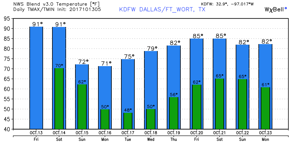 Tropics - A tropical disturbance that is well to the east of the Leeward Islands has a low chance of developing during the next five days. It should gain latitude and curve northward, and appears to be of no threat to land. Meanwhile, Hurricane Ophelia will become post-tropical cyclone this weekend, threatening Ireland and the U.K. The rest of the Atlantic Basin is quiet. Hurricane season runs all the way through November 31. See the Texas Weather Discussion Video for more details.
The cold front that came through Tuesday morning is now lined up from near Grove Hill to Montgomery to near Lafayette, Alabama. Thanks to that, temperatures still feel much like fall this morning with upper 50s and 60s in some spots. But hotter air will make its way in through this weekend. Today will be sunny with fewer clouds in place, gradually getting warmer with highs in the upper 80s today. Tomorrow Through the Weekend - Tomorrow will be a bit warmer, starting out the day in the low 70s, warming up to the low 90s at the peak of the day with abundant sunshine. Saturday looks to be the same with highs in the low 90s. By Sunday, another cold front comes through our area, and scattered showers and storms will be possible along and behind of the front. Nothing heavy or widespread, though. Marching Weekend at Wylie - The weather should continue to be dry this Saturday. Highs should be in the lower 90s at the peak of the day, before cooling down into the low 80s by the finals awards announcements. Football Weather - A clear sky is in store for us for tomorrow's high school football games. Temperatures will fall from 87 degrees at kickoff to near the lower 80s by the final whistle. Summit High School will be on the road to take on Lancaster High School this Friday night (kickoff @ 7:30p). The game will be played under a clear sky. Temperatures should be close to 88 degrees at kickoff, falling into 79-82 by the end of the fourth quarter. Next Week - It should be cooler and drier by Monday with highs in the mid 70s for much of early next week. The rest of the week continues to be overall dry and pleasant with highs in the low 80s. Some places might even see lows in the 40s again, but that will come with time. 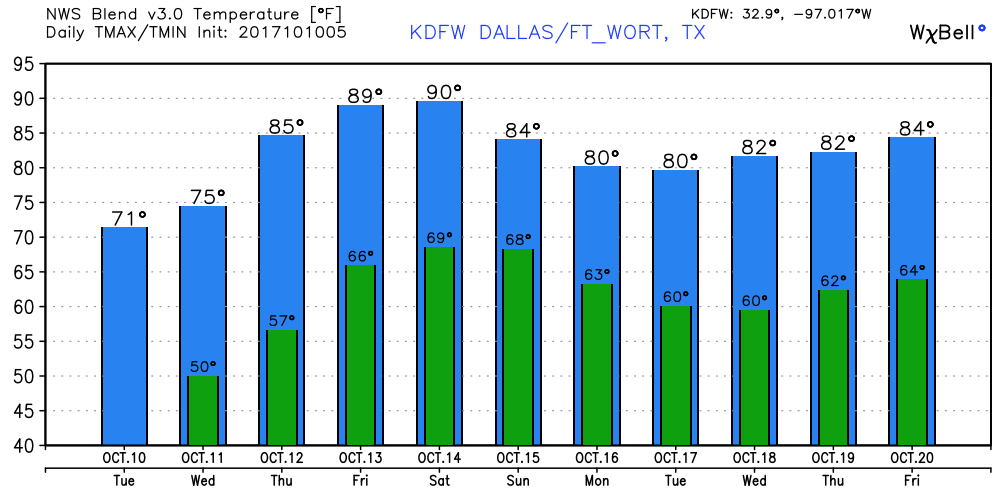 Tropics - Hurricane Ophellia is in the Eastern Atlantic, moving out towards the northeast. It should come close to Ireland and become post-tropical cyclone by early next week. The rest of the Atlantic, is quiet.
Still Chilly? - We are still in the chill zone this morning with many locations waking up to 40s for their mornings. However, it shouldn't stay cold all day, the sun should return in full force today, along with high temperatures in the mid 70s. Don't expect any rain until maybe this weekend. Tomorrow and Friday - As an upper ridge builds back across the south again, drier air will start to feed into our state, which should also make us trend hotter with highs in the low 90s by Friday. The lows should also return to what we are used to as well. The Weekend - Humidity levels will begin to rise on Saturday, which should push us into the low 90s for that day. Then a cold front comes through on Sunday, which should give us increasing chances of isolated showers and storms along and behind the front.  Marching Bands at Wylie - Looks like the weather will be dry at the Wylie High School Stadium on Saturday with very warm days. The high should be in the low 90s. The humidity values will be at its peak on Saturday, so it may feel more like a summer day for some. Football Weather - A clear sky will be in place for Friday night football games. Temperatures will fall from 87 degrees at kickoff to near the low 80s by the final whistle. Summit High School travels to Lancaster to take on Lancaster High School Friday evening (kickoff @ 7:30p). The game will be played under a clear sky with temperatures being close to 85 degrees at kickoff, falling to the upper 70s by the final whistle. Next Week - Along that front, we should feel another cool airmass behind. Not as cold as yesterday, but cool enough to get temperatures down into the mid 70s with no precipitation for the rest of the week.  Tropics - Tropical Storm Ophelia is expected to become a hurricane within the next 24 hours, but should be no issue to land. The rest of the Atlantic Basin, is quiet. See the Texas Weather Discussion Video for more details.
Air You Can Wear - While the cold front came and went through our area, it did leave behind some scattered showers and storms this morning and a moist airmass with dewpoints in the 50s and relative humidity values in the 80s. Again, it also left behind scattered showers and storms at daybreak...  The weather for today, tonight, and tomorrow will consist of mostly sun with maybe a lingering shower or two. Severe weather is not expected this morning, and rain amounts should fall into the 1/2 to 1 inch range. Highs should be in the low 70s for both days (about ten degrees below average). Thursday and Friday - Dry, hot weather continues for North Texas with abundant sunshine and above average temperatures. We will continue to stay very warm with highs in the mid to upper 80s. The Weekend - Sunny, dry, and warm weather will continue to prevail. By Sunday, global models continue to suggest another cold front coming through, bringing a chance of isolated showers and storms during the day. Otherwise, expect mostly quiet conditions with highs in the 85-90 degree range. Wylie Marching Invitational - The weather looks to be pleasant for marching bands on the field at the Wylie High School Stadium this Saturday. Highs will continue to be in the upper 80s. Football Weather - Another clear night for high school football games on Friday; temperatures will fall from the upper 80s at kickoff to the low 80s by the final whistle. Summit High School travels to Lancaster as they take on Lancaster High School on Friday night (kickoff @ 7:30p). The sky will be fair with temperatures at around 86 degrees at kickoff, falling to about 80 degrees by the end of the fourth quarter. Next Week - The weather now looks mostly dry and cooler with highs ranging from the mid 70s to low 80s.  Tropical Storm Ophelia is still going in the Central Atlantic... this storm poses no threat to land, and should continue to move east. The rest of the Atlantic Basin, is quiet. See the Texas Weather Discussion Video for more details.
Dry Through the Weekend - This will still most likely be the shortest thing on this update. Most of this blog update will be directed towards Tropical Storm Nate... Dry, warm weather is in store for North Texas this weekend with a good supply of sunshine for both days with highs in the upper 80s. As usual, we have a mild start to our day in North Texas, with DFW Airport recording a temperature of 71 degrees at 5:40 AM. Tropical Storm Nate - Tropical Storm Nate, which was upgraded nearly 24 hours ago, is currently located in the western Caribbean. Here are some important key points this morning regarding this system... *Nate is forecast to reach minimal hurricane strength by NHC just before landfall near the mouth of the Mississippi River late tomorrow night. From there, the circulation center moves through South Mississippi, and North/Central Alabama Sunday and Sunday night 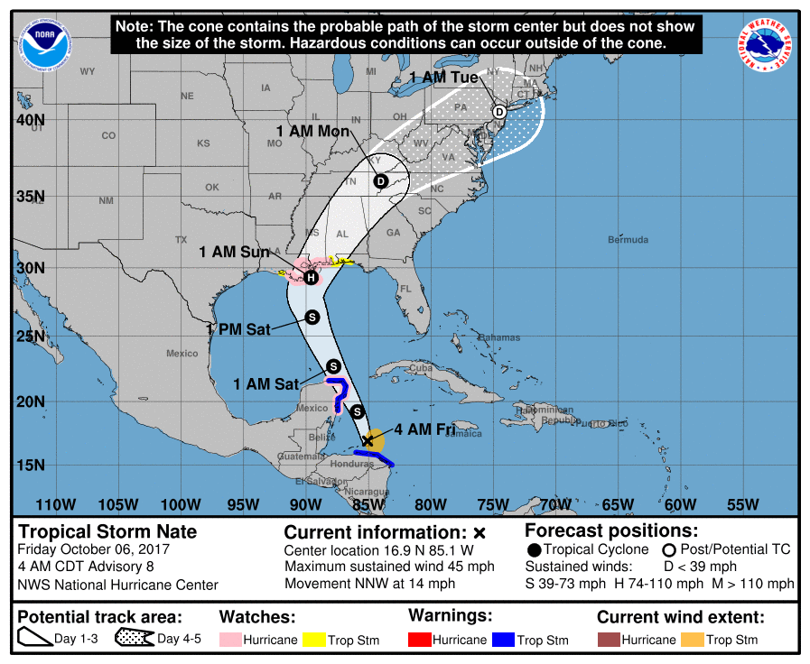 *Nate is forecast to reach minimal hurricane strength by NHC just before landfall near the mouth of the Mississippi River late tomorrow night. From there, the circulation center moves through South Mississippi, and North/Central Alabama Sunday and Sunday night. *The GFS and a number of tropical models suggest Nate will not reach hurricane strength, however, due to dry air, westerly shear, and cooler SSTs (sea surface temperatures) near the coast. One way or another, the impact will be pretty much the same for the Gulf Coast region. A Storm Surge Watch is in effect for... * Morgan City Louisiana to the Alabama/Florida border * Northern and western shores of Lake Pontchartrain A Hurricane Watch is in effect for... * Morgan City Louisiana to the Mississippi/Alabama border * Metropolitan New Orleans * Lake Pontchartrain and Lake Maurepas * Punta Herrero to Rio Lagartos Mexico A Tropical Storm Watch is in effect for... * Mississippi/Alabama border to the Okaloosa/Walton County Line * West of Morgan City to Intracoastal City Louisiana *Baldwin County officials have a voluntary evacuation recommendation for areas south of Alabama Highway 182 (Beach Boulevard) in Gulf Shores and Orange Beach, and the Fort Morgan peninsula beginning this morning. Also, a voluntary evacuation recommendation has been issued for the Causeway (U.S. 90) in Spanish Fort. *Wind and rain will increase on the Gulf Coast late tonight and through the day tomorrow. A storm surge of 1-3' is possible on the Alabama Gulf Coast and through the western part of the Florida Panhandle, and a few isolated tornadoes are possible well tomorrow. Rain will be heavy at times, but it won't rain all day.  *Weather conditions will slowly improve on the coast by Sunday afternoon as Nate moves northward. *Most of the rain for the northern half of Alabama will come Saturday night and Sunday; rain amounts should average 1-3", with isolated heavier amounts of 4 to 5" possible. Major flooding problems are not expected, however, since Nate will be moving along at a pretty good clip. *Pressure gradient winds of 20-40 mph are possible over much of Alabama tomorrow night and Sunday. Probably not high enough for major tree and power line damage, but a few trees could come down. *The main tornado threat Sunday will be south of a line from Mobile to Montgomery to Opelika. For now the tornado threat over North Alabama looks rather low.  *Winds will diminish Sunday night, but lingering showers are likely Monday. Football Weather - For high school football games tonight, the sky should be clear with temperatures near 79-82 at kickoff, falling towards the mid 70s by the final whistle. Next Week - A cold front arrives early next week, which will significantly bring temperatures down to the mid 70s in North Texas. Earlier in the week, global models were suggesting a little bit of moisture along the cold front, but that idea is now out and we should continue to stay dry for the next seven days. See the Texas Weather Discussion Video for more details.  Dry Through The Weekend - The easiest part of this blog update involves today through the weekend. Expect dry weather for North Texas this weekend with a good supply of sunshine with highs in the upper 80s. We will continue to have mild mornings, with lows in the 70s in most spots. Tropical Depression 16 - The weather for the weekend for the Southeast part of the U.S will be greatly determined by how this system behaves, which is now skirting the coast of Central America. Here are the important points... *The depression is still expected to become Tropical Storm Nate later today once it moves off the Central America coast. *NHC has adjusted the track to the west overnight, now suggesting landfall will come across Southeast Louisiana, and then South Mississippi Sunday morning. But, don’t focus on the exact forecast track, especially at the longer ranges, since the average NHC track errors are about 175 and 225 statute miles at days 4 and 5, respectively. More changes are very possible. 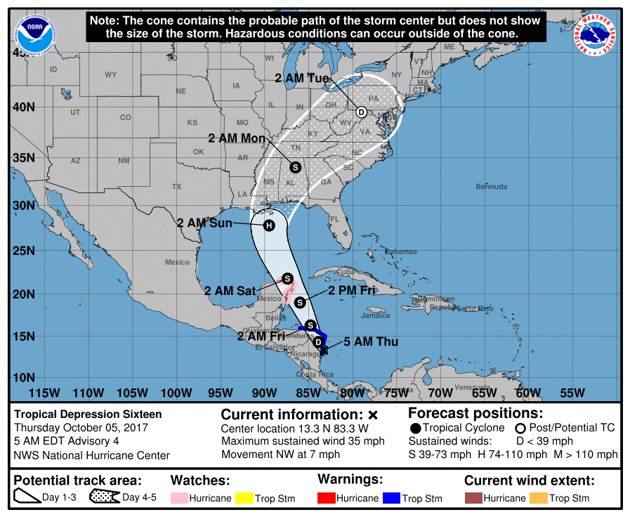 *The European global model shifted to the west on the 00Z run, in better agreement with the GFS and other tropical models. But, there is considerable disagreement concerning the timing of landfall; the Euro is much slower, showing the system moving into the Central Gulf Coast Sunday evening. On the other hand, the North American Mesoscale (NAM) model shows landfall late Saturday afternoon. The bottom line is that uncertainty remains in the forecast. *NHC suggests that “Nate” will be a category one hurricane at the time of landfall, but the system will encounter cooler water near the coast, some westerly shear, and also some dry air. The last two runs of the GFS shows only a weak tropical depression or storm moving up into the Gulf Coast, and the NAM is in fairly good agreement. So, there is a chance this doesn’t reach hurricane strength. But, there is only marginal skill in forecasting the intensity of a tropical cyclone four days in advance. *We note SPC has a “marginal risk” of severe weather defined for the Central Gulf Coast Saturday; a few isolated tornadoes are possible there. 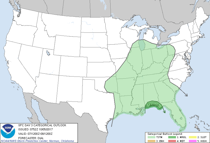 *It is too early to know if there will be a tornado threat inland Saturday night and Sunday. It depends on the strength and structure of the tropical system.
*If you have a beach trip planned this weekend, I would still hold off on changing plans until later today. But, it looks fairly certain that the weekend will be wet and windy for places like Gulf Shores, Pensacola Beach, Destin, and Panama City Beach. Conditions there improve Monday. Next Week - Dry, warm air should continue to linger across the state on Monday. Then, cooler, moist air should filter our region by Tuesday, where highs should drop to the mid 70s in most spots. See the Texas Weather Discussion Video for more details. Radar Check - We do note a few showers this morning on the map. Nothing widespread, just some light to moderate rainfall.  Although this is supposed to taper off by the afternoon and evening hours, the chance of rain will be low, but not zero. The high today will be around the 84-87 degree mark with clouds still sticking around. And we note that quiet, warm weather is in stock for us tomorrow and Friday. While we have that, the western U.S. will continue to be cold and unsettled; some parts of Montana has received two feet of snow. What's Going On Now In The Gulf? - Confidence is now high that a tropical depression or a storm forming in the Gulf of Mexico during the next 48 hours. This system will travel to the north or northeast, going through the Gulf of Mexico during the weekend. Beyond that time frame, we can't give you any other specifics. The Disturbance (Invest 90L) is located in the Southern Caribbean, just off the coast of Central America. Until this disturbance gets better organize, and we are able to receive data from hurricane hunters later this week, models will continue to struggle and disagree on a solution. The American global model, the GFS, features the system making landfall near New Orleans on the Louisiana Coast. However, the better-performing European model (ECMWF) shows landfall close to Tampa and Tampa Bay. Going forward, here are a few key points for any potential questions... *If you have a beach vacation planned this weekend, I would not cancel yet. Simply too early to know the final outcome of the tropical situation, but you do need to be aware that a tropical storm could form and be a high impact event for some part of the Central Gulf Coast. *The amount of rain in Southeast will all depend on the track of the tropical low. If the Euro solution is correct (landfall near Panama City Beach, with a movement into Georgia), when we will be on the “dry side” of the system with some rain certainly possible on Sunday and Monday, but the heavier totals will be east of the region. On the other hand, if the GFS is right, then, the Southeast will get a good wet down Saturday and Sunday. *The name of the system, if it becomes a tropical storm, will be “Nate”. Just keep an eye on the blog for updates as the weekend gets closer. 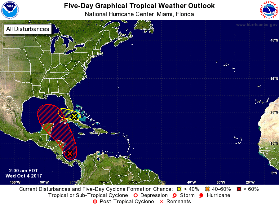 Next Week - Next week looks quiet with a strong cold front coming through which will significantly bring temperatures down. See the Texas Weather Discussion Video for more details. 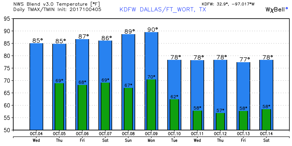 **No Texas Weather Discussion Video this morning due to planning** Radar Check - Really not much to say looking at the radar, other than scattered showers about, mainly to the east of I-35.  We should see more of these increase throughout the day, especially with the surface front coming through. The best chances of rain for DFW will come after 4:30 and end after 10:00. But in reality, you should prepare to see some rain anytime of the day.  I still think the higher chances of rain will remain to the east of I-35, but please note that this model will NOT reflect actual conditions. Scattered to perhaps numerous showers and storms will be likely for all of North Texas today. Some storms may be strong to perhaps briefly severe. Otherwise, the high should be in the low to mid 80s, with ample cloud cover during the morning/afternoon hours. Tomorrow - The potential for scattered showers and storms still exists, mainly in the morning hours. Yes, there will be a possiblility, but it shouldn't be as widespread as today. The high should reside in the mid to upper 80s with clouds deteriorating. Thursday and Friday - We trend drier heading towards the weekend, with rain looking less and less likely in the coming days. Highs should remain in the upper 80s, which is a great look for high school football games. The Weekend - Not much change. We could see a few showers and storms on Saturday, but otherwise, most locations will stay dry with highs in the upper 80s. Next Week - After Monday, cooler air will be featured with a strong cold front coming through with highs dropping into the low 70s and lows reaching into the 50s. 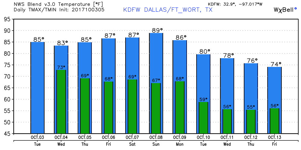 Tropics - All eyes will be on the Gulf of Mexico and the Caribbean Sea where development will be possible in coming days. While the formation of a tropical cyclone is looking more likely with time, it remains unknown whether or not this becomes a tropical storm or depression. For now, the main threat will be heavy rain for parts of the Gulf of Mexico and the southeast U.S. Coast. 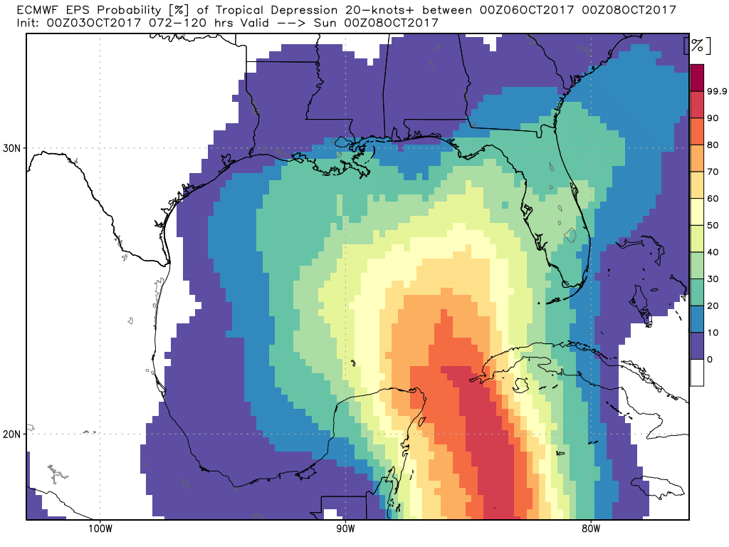 Happy October! - Although the month of October has arrived, it certainly won't feel like October for at least the next seven days. We start the day in the 60s to low 70s, warming to the low 90s by the peak of the day today. If this verifies, I do strongly believe that this could potentially be the last 90-degree day for this year, after having above-normal temperatures for a while. For tomorrow, we should see a noticeable change in temperatures with highs reaching the low to mid 80s for that day, which is still a few degrees above normal temperatures. We will have to wait until next week to get a "real feel of October". However, the chance for scattered showers and storms start to increase by Tuesday night (after midnight) and Wednesday morning, tapering off by the evening hours. Midweek - Aside from the rain, the rest of the week looks dry with clouds still in place. Both days should have ample cloud coverage, which will aid in making it feel cooler than it really is. Friday and the Weekend - Sunshine returns back in full force on Friday, but a few clouds look likely during the weekend with highs in the upper 80s again. No precipitation in the forecast for any of these days. Conditions should also be nice and dry for high school/college football games taking place on Friday and Saturday. Also, go to the State Fair as well! It should be pleasant there too. Next Week - Early next week, another cold front makes its way south, which will significantly drop temperatures to the mid to low 70s for the highs, even into the 50s for the lows. This would be the first "official" fall-like cool down of October, and man, it will sure feel like it. 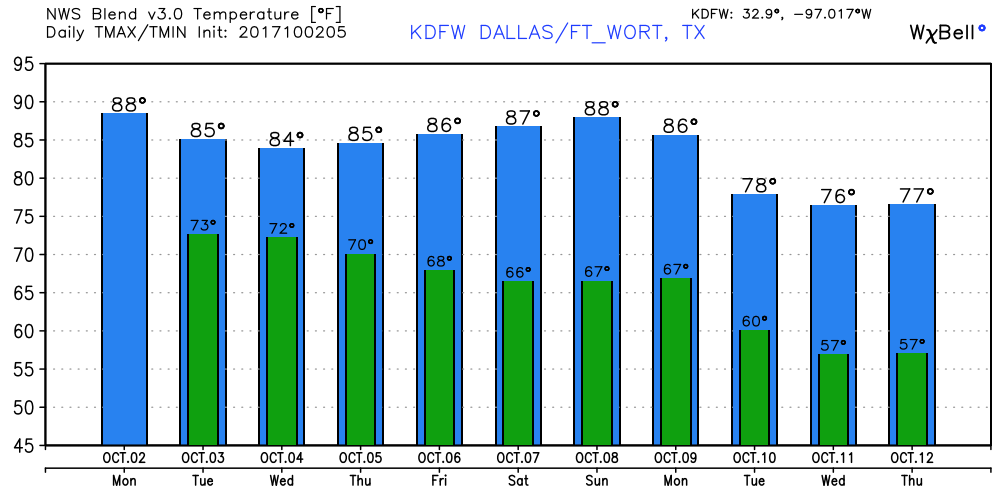 Tropics - Good News! For the first time in almost two months, tropical cyclone formation is not expected for the next 2 days! However, we do have to keep an eye on an area of disturbed weather in the Northwestern Caribbean Sea. The global models don't fully develop this during the next 7-10 days, but this is still something to watch. See the Texas Weather Discussion Video for more details. 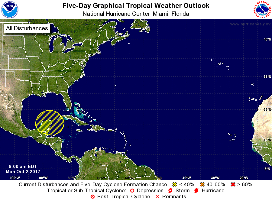 |
Archives
April 2024
Categories |
 RSS Feed