
|
Air You Can Wear - Temperatures this morning as you wake up and start your morning commute... DFW - 54 Arlington - 52 Love Field - 62 Denton - 55 Weatherford - 56 Burleson - 54 Cleburne - 54 Today will be the hottest its been in recent days with most locations reaching the upper 80s this afternoon; about 13 degrees above average for October 26. Tomorrow - A cold front will come through later today, which will set the stage for a very chilly day on Friday. We start the day out in the mid 30s, meaning some places in North Texas will probably see their first frost of the season. Some of the naturally cooler pockets will see their first freeze of the season. (Be sure that you plan ahead for this because this may kill many crops, ending the growing season.) Additionally, sustained winds of 25 mph is likely with gusts up to 40 mph. A Wind Advisory will go in effect today at 9 PM this evening until 10 AM Friday morning. We will mention the chance of an isolated shower or two during the day. The Weekend - Saturday should be very similar to Friday; lows in the mid 30s, only warming up to the upper 50s during the afternoon hours. A frost/freeze is more likely on Saturday due to the calmer winds during the night. Abundant sunshine is still in full swing though, and we should continue to remain dry. Sunday should be a significantly warmer day starting out with temperatures near 48, warming to near 60 by the peak of the day. Football Weather - For the high school football games tomorrow night, I do think that most, if not all of the rain should be out of here by this late afternoon. Most stadiums will be dry. The sky will be cloudy with temperatures falling from the mid 50s at kickoff to upper 40s by the final whistle. Summit High School hosts Midlothian at R.L. Anderson Stadium for its homecoming game (kickoff @ 7:30p). Things should remain quiet and dry with temperatures falling from near 53 at kickoff to 48 by the end of the fourth quarter. Next Week - Monday will be another dry day. By Tuesday, another cold front will come through, which will bring more chances of showers and storms throughout the day on Tuesday. The rest of the week looks dry with highs generally staying in the 70s. 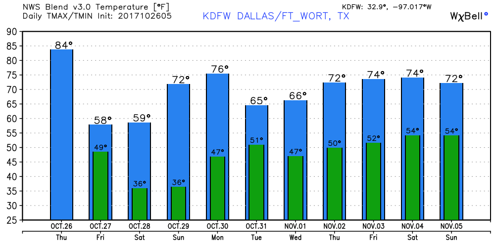 Tropics - A disturbance that is located in the northern Caribbean has a medium chance of developing during the next five days. It should travel northeast along the cold front this weekend, skirting the U.S East Coast. If anything, heavy rain will be possible with the system. The rest of the Atlantic Basin remains quiet. See the Texas Weather Discussion Video for more details.
|
Archives
March 2023
Categories |
 RSS Feed
