
|
Slightly Warmer - Starting out the day, we are slightly warmer than recent days, with temperatures hitting the 60s in most spots. During sunrise, you should see a cloudy sky due to the shortwave trough to the west of the state. It should stay mostly cloudy throughout the day with highs sticking in the low 80s/upper 70s. We will also need to mention the chance of a few showers during the afternoon/evening hours. Saturday - For most of the day on Saturday, we should still be completely dry with the temperature still peaking out near the mid 80s during the late afternoon. After sunset, this is where things get a bit interesting here. Back in west Texas, showers and storms should develop along a cold front and progress to the east, mainly during the overnight hours. This where the SPC has put some spots in north Texas and much of central Oklahoma under the "enhanced" risk of severe storms. 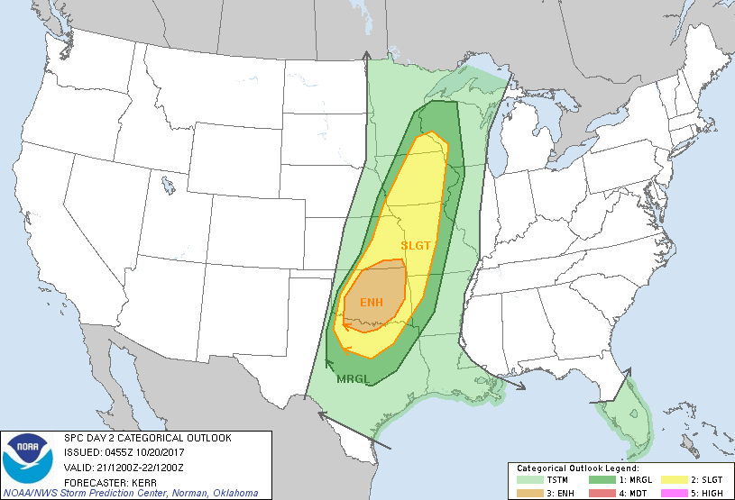 Where we are in DFW, we are still in the standard 'slight' risk for severe storms for Saturday and Sunday. Keep in mind that these outlook run until 7:00 AM the next day. The Setup - A trailing cold front should continue to move to the east. Once it reaches west Texas during the evening hours on Saturday, severe storms should begin to develop. Due to the combination of instability values of 2000-3000 j/kg and some shear of near 30 knots, severe storms capable of producing damaging winds, large hail (some greater than 2" in diameter), and isolated tornadoes will form along the cold front and should move mainly to the east. Most of the development will likely take place in the enhanced risk area, where the area of discrete storms during the early phase is most likely. Where we are, we most likely won't get the squall line until likely past midnight. However, severe weather will still remain a possibility with the threat for mainly damaging winds and some hail. So, for a 12 hour window, the risk for thunderstorms should begin around 9:00 Saturday evening and end at 9:00 Sunday morning. After the storms, the rest of the Sunday looks refreshing and cool with highs in the low 70s. Football Weather - For high school football games tonight, most of the games in North Texas will be played under a cloudy sky; temperatures should fall from the low 70s at kickoff to near the upper 60s by daybreak. Summit High School hits the road once again to take on Red Oak (kickoff @ 7:30p). For now, temperatures should fall from 73 at kickoff to near 68 by the final whistle. We will have to mention a risk of a shower or storm during the game, as the chances will still be possible this afternoon/evening. Next Week - We get rid of 80 degree weather for a while, and 70s and potentially 60s flood the region next week. No sign of any widespread rain event. See the Texas Weather Discussion Video for more details. 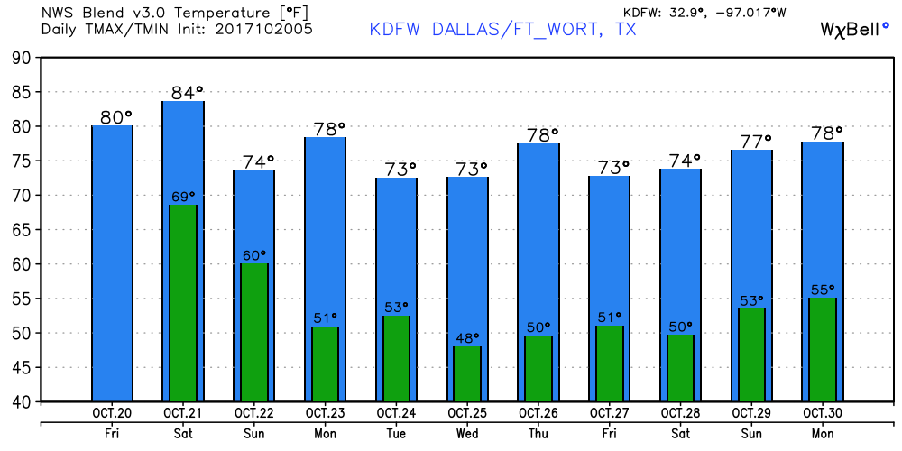 Tropics - The Atlantic Basin remains quiet, and no new tropical cyclones is expected for the next week.
|
Archives
March 2023
Categories |
 RSS Feed
