
|
STORMY WEATHER PATTERN - First off all, severe weather threats like this are VERY normal in the south in November and December, as these are our common late severe weather season months. There is absolutely no need to be fearful of this thing, just be prepared. Knowledge is absolutely imperative in these weather situations and hopefully this post will inform you of what you need to know. AFTERNOON/EVENING - The SPC now has the "enhanced risk" (level 3 of 5) of severe storms around the Interstate 35/45 corridor surrounding the Austin, Waco, Round Rock, and College Station areas. The standard "slight risk" (level 2 of 5) of severe storms runs from Midland in West Texas through Shreveport in Louisiana. This does includes areas along and south of Interstate 20 in the DFW Metroplex, and is south enough to include the city of San Antonio. Lastly, the "marginal risk" (level 1 of 5) of severe storms surrounds the rest of the North Texas region as well as Houston, Lubbock, Amarillo, and surrounding areas. 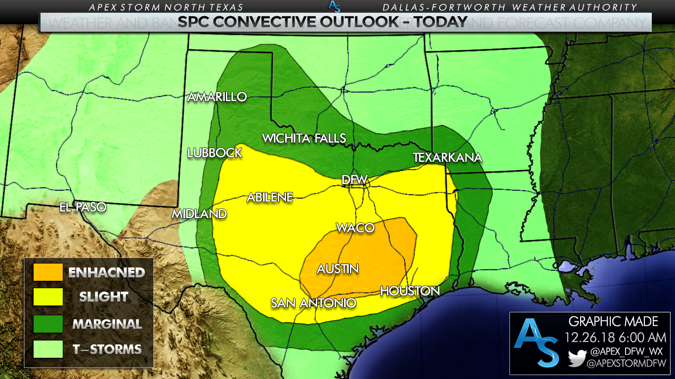 New model guidance this morning shows a relatively volatile setup this evening into the overnight hours; the combination of moderate instability, very strong directional shear, and strong backing of the winds are pushing the Significant Tornado Parameter (STP) up to a max of 10.6 over parts of South Texas this evening... 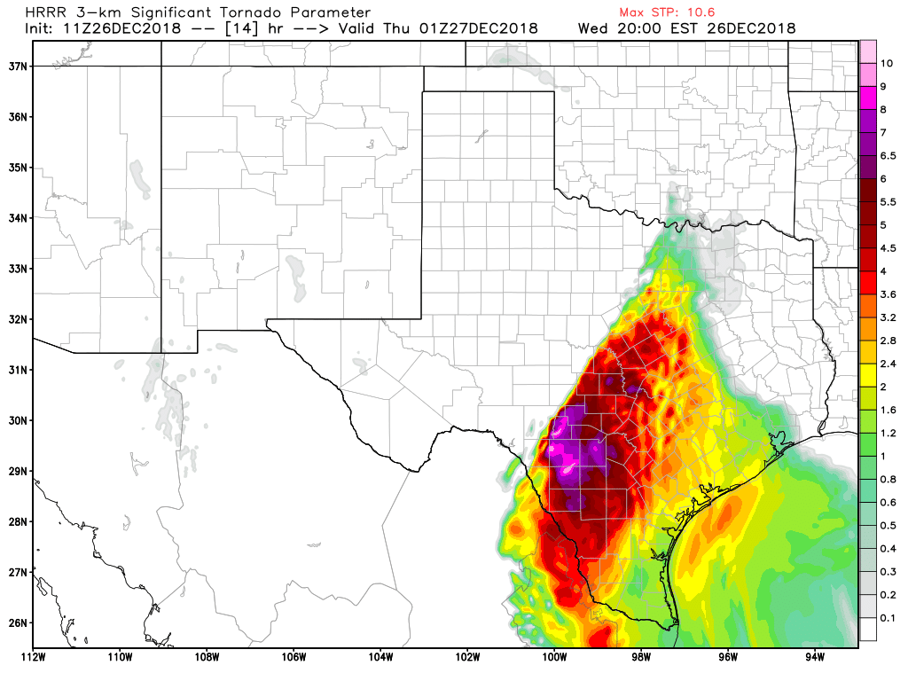 TIMING - Although scattered thunderstorms will be occurring through most of the day today, severe thunderstorm development will initiate at around 2:00 PM in West Texas gradually moving east, persisting through midnight tonight. A few storms could linger over East Texas tomorrow morning. THREATS - Storms this evening into the overnight hours could produce all modes of severe weather. Large hail (2" in diameter in the worse-case scenarios), damaging straight-line winds, and a few tornadoes can be expected. The highest tornado threat presides in the Enhanced Risk area near Austin. Based on the newest data this morning, I would not be surprised if we see one or two strong tornadoes, mainly in the enhanced risk area over Central Texas. If we see more discrete supercells before the sun goes down, the tornado and hail threat will be much higher from those cells. Eventually, storms will merge into a squall line later tonight, mainly posing a threat of damaging straight-line winds. A few brief spin up tornadoes are possible from that line as well. RAIN - Lots of rain can be expected from this storm system, and amounts of up to two and a half inches or greater can be expected for areas to the east of Interstate 35, which could pose a flash flooding risk in some spots. Lighter amounts of rainfall can be expected elsewhere, but still be aware because that will not mitigate the threat of localized flooding. 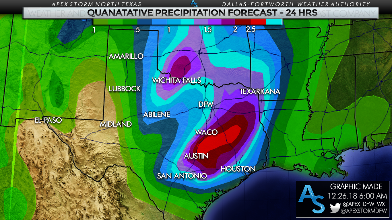 In the most flood-prone areas, the Weather Prediction Center has issued a Slight Risk of excessive rainfall which may lead to flooding at times.  OVERALL CONFIDENCE - The confidence in the potential of severe thunderstorm development is very high today, but there is still just a little bit of uncertainty as we will have scattered showers and thunderstorms that might impact atmospheric conditions this evening. We will be watching how far north the instability at the surface can make it, which will determine if we will have a localized "maximum" tornado potential. But most of the severe storms will come in a east-moving squall line with mainly damaging straight-line winds.
WILL THIS BE LIKE DECEMBER 26, 2015???? - I really don't like this question. December 26, 2015 had anonymously high instability values with support from strong wind shear and backing of the winds. While wind shear will be impressive today, instability will be lower with this threat of severe weather. Generally speaking, the event in 2015 was more of a 'once in a decade' type event. But remember, if there is only one tornado out of the entire state, and it happens to come down your street, that is your December 26th. PLAN OF ATTACK - During the day today is a good time to review and revise your tornado plan. -Make sure you can hear warnings today if they are issued. NEVER RELY ON AN OUTDOOR WARNING SIREN. IF THAT IS OUR MAIN SOURCE OF HEARING WEATHER WARNINGS, YOU HAVE NO HOPE OF HEARING THEM INDOORS WHEN IT IS NOISY OR WHEN YOU ARE ASLEEP. It is wise to have a NOAA Weather Radio in your home or place of work. Moreover, having a good smart phone app like this one will serve you well if you typically get weather information from your phone. -Know the safe place in home. This is typically a small room on the lowest floor near the center of your house, away from windows if you don't have a basement, safe room, or storm cellar. If you are in a mobile home in a tornado warning, you must leave and go to a shelter or a sturdy building. -In the safe place in your home, it is wise to have a helmet for everyone in your family to wear. It is also wise to have a portable air horn to get the attention of first responders if you need help. Lastly, be sure to wear hard sole shoes because in the worse-case scenario, you don't want to talk over a debris field with bare feet or socks. Me and Jonathan Williams will be on social media throughout the day answering questions, and updating the current situation. Stay tuned for updates! .*no Texas Weather Discussion Video this morning*
RAIN AT TIMES THROUGH MORNING - On the maps, there is a deep surface low located over our state that’s moving eastward, which has brought some strong storms to parts of North Texas and snow to parts of West Texas yesterday. This system will continue to bring clouds to the region today with occasional rain at times through the morning. It will also continue to bring lots of wind through the morning, and the wind advisory will expire at noon today. We will transition to a cold, windy and dry afternoon with highs in the mid 40s. Once the storm system moves eastward, the weekend should be absolutely perfect with mostly sunny skies. Highs should be in the low 60s with morning lows in the upper 30s. NEXT WEEK - A dry airmass will cover much of the state, meaning rain-free weather with seasonal temperatures. Expect mostly sunny days and fair nights. Highs will be in the low 60s with morning lows in the low 40s. VERY WET WEATHER AHEAD - A storm system will organize to the west today over West Texas, and brings rain at times to the region this afternoon through Friday afternoon. Most of the morning and early afternoon hours will be dry with highs holding in the low 60s. While some parts of North Texas could see rain as early as 2PM, most of the rain will hold off until later this evening. The air will be stable for areas to the west of the DFW Metroplex. However, SPC maintains a "marginal risk" and "slight risk" of severe storms for areas to the north and east of the metroplex. A few storms here could produce strong, gusty winds, and there is a very low ended threat of a brief, isolated tornado.  Tomorrow will be a wet morning with a cloudy sky and rain at times through the morning hours. Most of the wintery precipitation (if any) will be confined to areas to the west of the metroplex. No accumulations or significant travel issues are expected Friday morning. The high will hold in the upper 40s Friday. Rain totals from now through Friday afternoon will be anywhere from the 1/2 to 2 inch range, so no flooding issues is expected. THE WEEKEND - The storm system will lift to the northeast, away from North Texas. The weekend should be filled with mostly sunny skies with highs in the mid to upper 50s and low 60s around. Clouds should clear on Sunday. NEXT WEEK - It looks like a rather benign weather pattern sets up across Texas; we expect dry weather throughout the week with highs mostly in the upper 50s and lows in the mid to upper 40s. See the Texas Weather Discussion Video for more details. 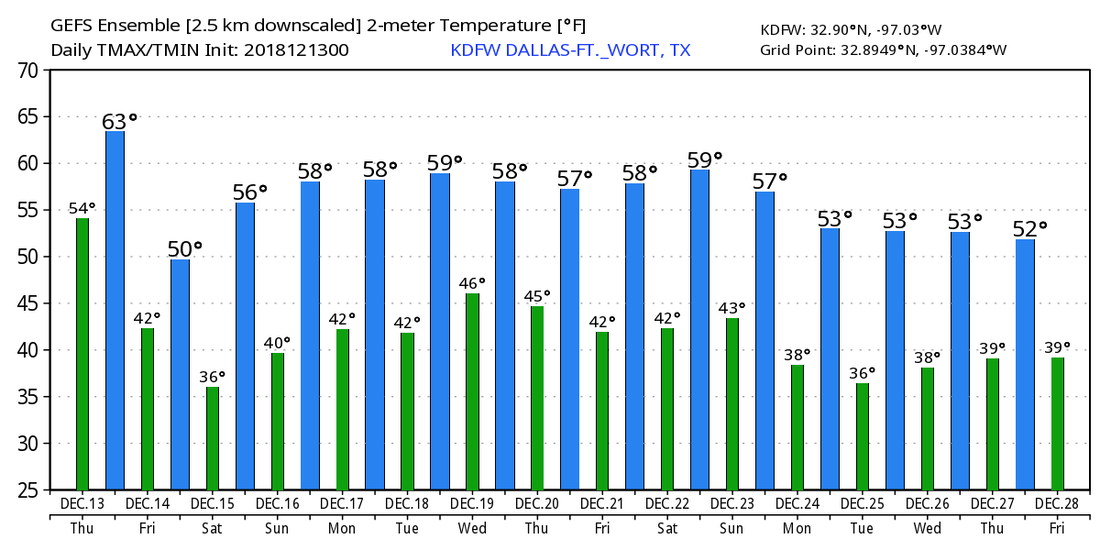 COLD MORNING - It's another chilly morning across North Texas with temperatures mostly in the low 30s and below for areas outside of the metroplex. DFW Airport recorded a temperature of 35 degrees this morning, about three degrees below our average low of 38. The good news is we will rebound nicely this afternoon with highs in the mid to upper 50s with mostly sunny skies. We trend even warmer tomorrow with afternoon highs in the low 60s with mostly sunny skies. WEDNESDAY AND FRIDAY - Not much change. We stay dry and sunny on Wednesday with highs mostly in the low 60s. A storm system moves through the Southern Plains on Thursday which could squeeze out a few showers during the afternoon. Otherwise, we stay dry with a mix of sun and clouds. We trend sunnier on Friday with highs in the mid 50s and the upper 50s on Thursday. THE WEEKEND - Not much significant change in our current pattern. We stay mostly dry with more sun than clouds. Highs will be in the upper 50/low 60s range for both days. NEXT WEEK - The early part of next week remains mostly dry across the region with more sun than clouds and highs in the low 60s. See the Texas Weather Discussion Video for more details. 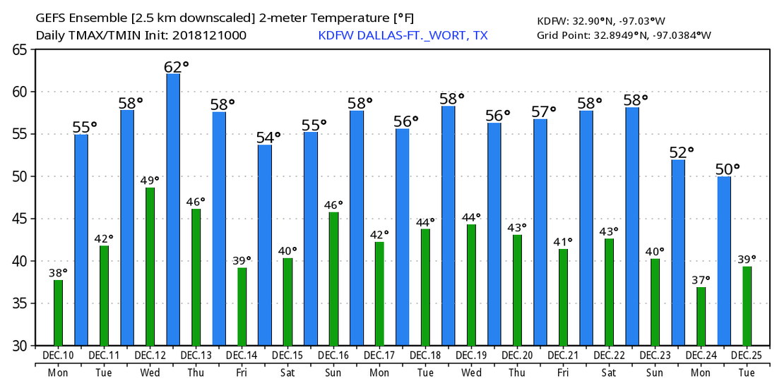 RADAR CHECK - We have a good patch of rain for areas to the southeast of Dallas, generally to the south of I-20. Temperatures are above freezing with no issues with ice at all. Today will be cloudy with a good, soaking rain likely. Where rain falls, temperatures will not get out of the mid 40s. More rain is expected for areas to the southeast of DFW. The good news is no severe weather expected, just an all-day type of event. Rain amounts over North Texas will average at around 1-3 inches. No major flooding issues is expected for North Texas at this time. THE WEEKEND - We see rain persist through Saturday afternoon as the storm system exits the area. For now, periods of rain is still likely for North Texas, but the overall threat of significant winter weather issues has diminished greatly over the past 24 hours. However, some snowflakes/light snow is possible for some of our northern counties, but no significant travel issues are expected at this present time. At this point, it is looking more and more likely that temperatures will be above freezing by the time the wrap around arrives, and if this happens, no impact is expected. The high will be in the mid 40s falling during the day. The storm system quickly moves out by Sunday, and we begin to mention drier weather with highs still holding in the mid 50s. NEXT WEEK - A disturbance develops in the South-Central Plains, and I would not be surprised if that squeezed out a few showers at times on Wednesday. Otherwise, expect a mostly dry week with increasing moderation. See the Texas Weather Discussion Video for more details. 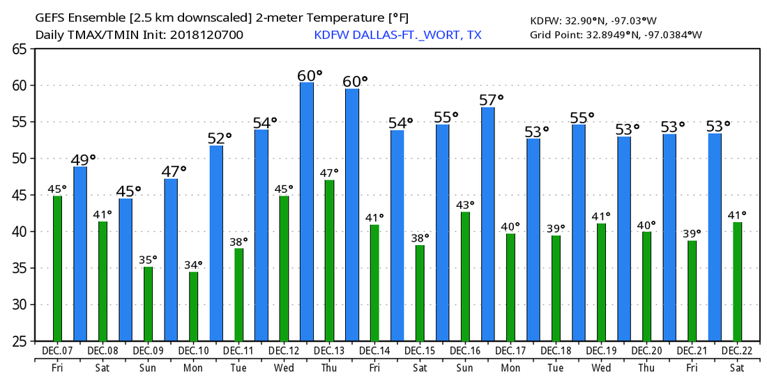 MOSTLY CLOUDY TODAY - Despite widespread cloud cover across the region, temperatures are in the low 50s to upper 40s this morning which is actually above our average low of 39. Today will be cool and a little wet with showers and rain increasing by the afternoon hours in advance of a potent storm system from the west. Highs will be in the mid 50s later today. FRIDAY AND THE WEEKEND - A cold, soaking rain is expected tomorrow as a surface low moves eastward across South Texas. No severe storms and probably no thunder. Just an all-day rain with temperatures holding in the low 40s over North Texas. Rain amounts of 3-5 inches are likely across the region. Sunday will be mostly dry after the storm system passes with highs reaching the mid 40s. SNOW? FLURRIES? - As the surface low begins to move eastward Saturday and colder air is pulled down into North Texas, there is an increasing risk of some snow/flurries across the North and Northwest part of the state Saturday evening into Monday morning. Based on forecast thermal and moisture profiles, there is a chance that this could put some impacts on travel Saturday night into the day on Sunday. Any rain that is still on the ground at that point would most likely freeze as soon as we hit below freezing. Any additional sleet/snow would cause more concerns for travel, especially for our north and western counties. But of course, this is still a few more days away and things could always change as the system gets closer. We will have our "first call" snow map released later this evening. The significant snow from the system will be mainly to the north and west of North Texas in a broad zone from the Texas Panhandle to Virginia and North Carolina. Some of the heaviest snow from this event is expected to fall in the southern Appalachians. Winter Storm Watches are already in effect for parts of the Texas Panhandle, Central Oklahoma, and areas into Missouri and Arkansas. 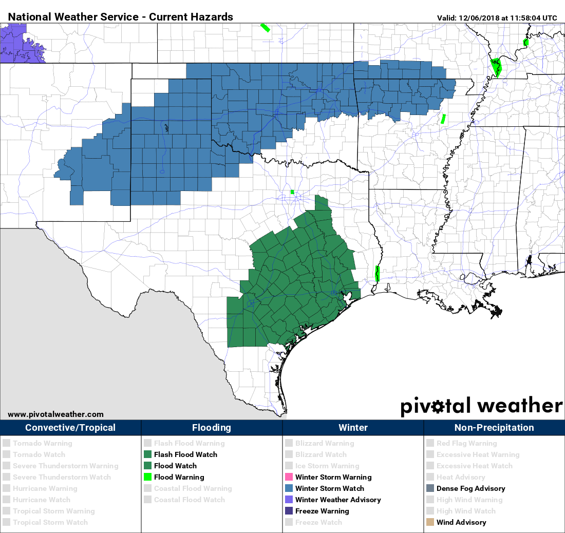 NEXT WEEK - Monday and Tuesday look dry with a slow warming trend, then rain and maybe a few thunderstorms should arrive Wednesday afternoon with a new system developing here, followed another shot of cold air. See the Texas Weather Discussion Video for more details. 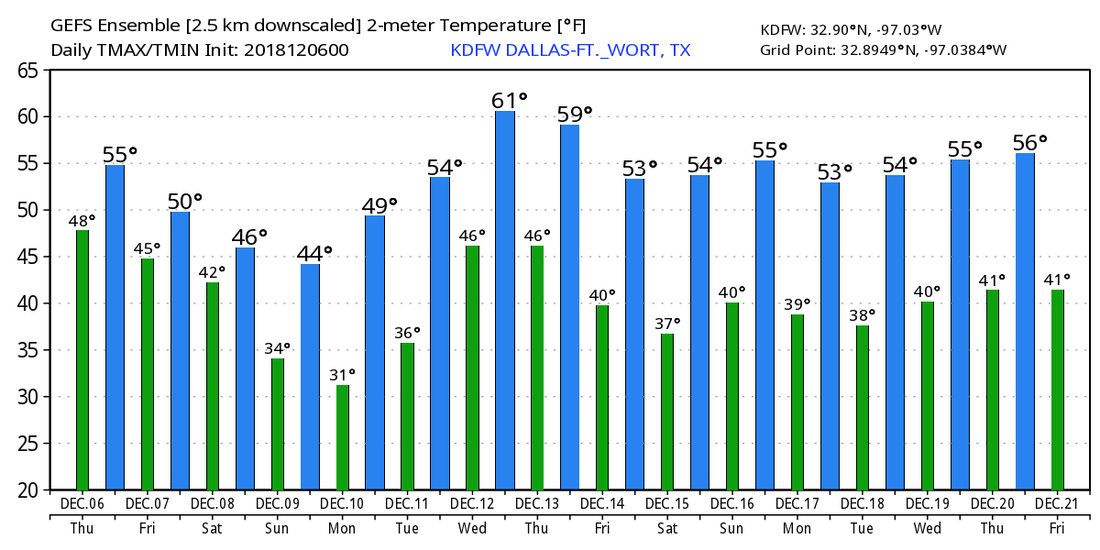 SUNNY BUT COLD - We are starting the day with basically freezing temperatures over most of North Texas; the sky will be sunny today with highs in the in the mid 50s later today, about more than five degrees below our average high. Another freeze is likely tomorrow morning with morning lows well into the low 30s. Clouds will increase tomorrow in advance of a potent storm system, and some rain will likely develop in the state Thursday afternoon/evening ahead of a storm system. Highs tomorrow will be in the mid 50s. FRIDAY AND THE WEEKEND - We are still forecasting a cold, soaking rain for all of NTX Friday as the surface low continues to move across South Texas. Fortunately, no severe weather is expected in a cold, stable airmass, just lots of rain. The weather won't be much better for North Texas on Sunday; it will be another cloudy, cold day with widespread rain still in place. As the surface low progresses more eastward, and colder air continues to get pushed southward, there is increasing chance of snow flurries/freezing rain for parts of North Texas on Saturday. If we see this, this could cause some travel issues as a good 2/ 2 1/2 inches of rain would have already fallen and the surface would be cold enough for some of the rain on the ground to turn into ice in some spots. There is still a lot of uncertainties about this and a lot of things can and will change, though. For now, we are sticking with mostly rainy day on Saturday with highs only reaching the low 40s. We will get a real look of how the weekend might playout throughout the day today and tomorrow, so stay tuned. Sunday looks mostly sunny and dry with afternoon highs in the low 40s. NEXT WEEK - Monday and Tuesday look dry with a slow warming trend, then rain returns to the state Wednesday. See the Texas Weather Discussion Video for more details. 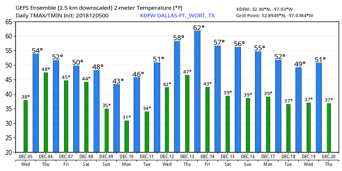 EVEN COLDER - This morning features very cold temperatures in the upper 20s to low to mid 30s across the region. With the cold front coming through yesterday, look for mostly cold days and chilly nights with highs in the 45-55 degree range with morning lows in the 30 degree range. It must be noted that the average high for DFW is 60. Morning lows will mostly be above freezing for much of the region, but it will still be pretty cold each morning through Thursday. Clouds will increase tomorrow in advance of a developing storm system to the west, and rain could reach the region very early Friday morning. COLD, WET START TO THE WEEKEND - A surface low is forecast to move along South Texas, setting up a good cold, soaking rain for much of the state on Friday and Friday night. Temperatures will be in the low to mid 40s over North Texas. Rain amounts of two and a half inches are likely over the region, and yes, it will pretty much be an all day type of rain if you are planning something outside. The surface low will move east into the Gulf Coast on Saturday, but global model are beginning to indicate more moisture from the back side of the system. This would mean that Saturday would be another wet and cold day. Highs will be in the upper 30s to low 40s regardless of precipitation. We should mention that snow/ice issues are likely over a good part of the Texas Panhandle, Oklahoma, Arkansas, and Tennessee during the day with this system, so be cautious if you are traveling to the north. The low will continue to move to the east, but global models are starting to indicate the potential of a few snowflakes/very light accumulation parts of West Texas into the western counties of North Texas very early Saturday morning. It is way too early to understand any impacts, just something to watch. The main significant snow/ice issues should be to the north and northwest of North Texas. NEXT WEEK - Monday will feature decreasing clouds, but the rest of the week looks mostly dry and sunny with slowly moderating temperatures... See the Texas Weather Discussion Video for more details. 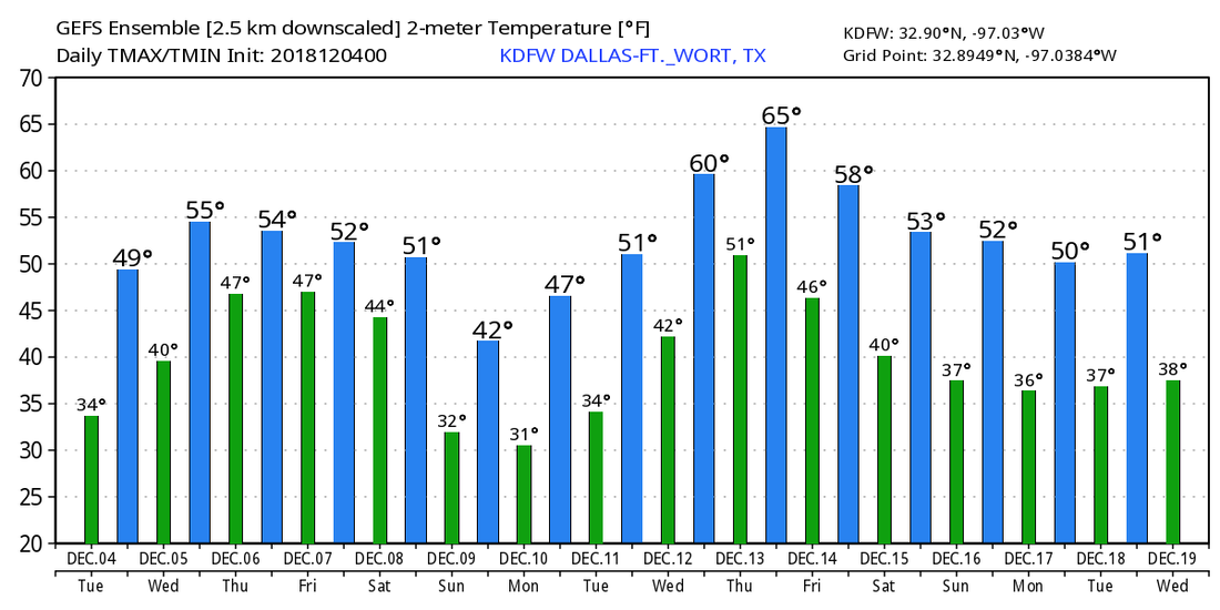 CHILLY START - Temperatures are mostly in the 40s across the metroplex, which is actually a few degrees above our average high of 40 degrees for December 3. A cold front comes through later today, so we won't warm much during the afternoon; we only project a high of around 50 degrees during the afternoon. The sky will mostly feature a mix of sun and clouds. We start tomorrow morning below freezing with overnight lows in the 30s. After a very cold morning, we are still cold by the afternoon with highs only in the mid 40s with mostly sunny skies. The good news is, the winds will not be strong, so it will not be a blistering cold. MIDWEEK - Not much change. Each day will feature a mix of sun and clouds with highs in the low to mid 50s by the afternoon. Overnight lows will be at the freezing mark on Wednesday, and in the low 40s by Thursday. I wouldn't be surprised if we could squeeze a couple of showers out by the afternoon hours. FRIDAY AND THE WEEKEND - A very potent storm system moves into the south-central plains from the Pacific, and that will be our next chance of widespread showers and thunderstorms statewide. The good news is, we are not expecting any severe weather at time, and rain amounts will mostly be in the 2-2 1/2 inch range. That same storm system will also be a catalyst for some "winter mischief" for parts of the Texas Panhandle and Oklahoma. However, global models have been trending this feature further south, getting close to some parts of North Texas. If we can get the colder air into the region faster than what the global model output is showing, we might have an increased chance of "winter mischief" of some sort for parts of North Texas. However, we do NOT expect any of that to happen at the present time; we will only mention the chance of widespread cold rain Friday with highs only reaching the low to mid 40s both Friday and Saturday. We will get a real look on how this storm system will behave by the middle of the week. If we don't see anything for the weekend, both days look mostly raw, cold days with highs struggling to get out of the low 40s with overnight lows in the low 30s to upper 20s. NEXT WEEK - Next week becomes gradually warmer with Monday still chilly, but gradually getting warmer towards the latter half of the week. Each day will feature a mix of sun and clouds. See the Texas Weather Discussion Video for more details. 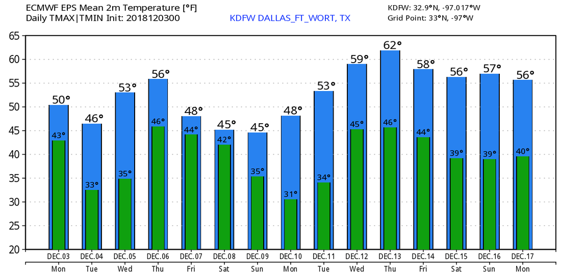 |
Archives
April 2024
Categories |
 RSS Feed