
|
hAs normal, we start off the day quiet with nothing on the radar. Due to drier air surging from the north, we should stay like this for a while. I doubt it will get much hotter though. Most locations are starting the day off in the low 60s/low 70s. Most should warm up to the upper 80s today with a few clouds. Football Friday Weather - Not much change. We should continue to be quiet and dry with comfortable temperatures. There could be an isolated shower or two hanging around... Just a small chance, though. We should have better details tomorrow. Temperatures should be in the middle 80s for the game. Summit High School has a home game this Friday, taking on Mansfield High School (kickoff at 7:30 PM). The game should be played in Vernon Newsom Stadium in Mansfield outside. Right now, the weather looks like it will be dry for basically all throughout the game, and temperatures should remain for in the mid 80s. Labor Day Weekend - Not much change. The European global model and the GFS continues to show dry air surging into the south, which will once again setup decent weather for all of the holiday weekend. It appears that all three days should see a mostly sunny sky with highs in the lower 90s with any chances for showers looking really low. Harvey - Tropical Storm Harvey is producing lots of flooding issues for the southeast corner of Texas, where water rescues are now underway for this region. When Harvey moves to the northeast, things should improve for that area... 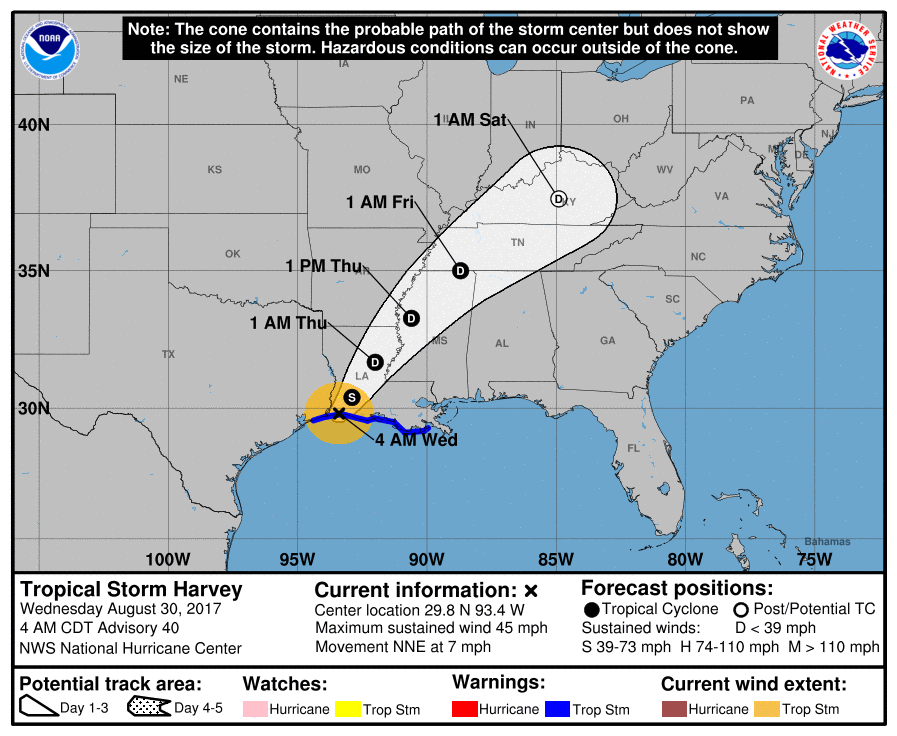 Invest 93L: A disturbance in the eastern Atlantic has basically a guaranteed chance of becoming tropical storm Irma during the next 48 hours. We currently do not know where it will ultimately end up, or if this will have any impacts on any part of the U.S. Coast. See the Texas Weather Discussion Video for more details.  Quiet Morning - Surprisingly, we are starting this morning quiet with no showers and storms about and with temperatures in the low to mid 70s, as usual. Although some locations could see scattered showers and storms, expect most locations to be dry today with highs in the low to mid 80s. We should also stay mostly dry tomorrow with mostly cloudy conditions again with highs in the mid 80s, staying below average for this time of the year. Midweek - This week's weather will all largely depend on how Tropical Storm Harvey behaves. It has already came through many locations in southeast Texas (including Houston), and caused catastrophic and life-threatening flooding in some densely populated areas. This will continue to pour heavy rain over that region until the latter half of the week due to virtually no steering currents. When it finally decides to move on Thursday, we could experience its effects. We should stay cloudy for most of of the week with occasional scattered tropical downpours at times. We can't really say what time it is going to rain yet because the threat really lasts all day, but scattered showers and storms will be possible all throughout, especially during the latter half of the week. Weekend - After the remnants of Harvey moves well to our northeast, we are left with drier air creeping back in which will create more sunshine than clouds. Mostly all locations in north Texas should enjoy sunny skies with highs in the upper 80s. Next Week - Another disturbance comes through the area, which will also pose another risk for a few showers and storms early next week. Details are not clear now, but highs should still stick around in the lower 90s to upper 80s next week, still staying below average.  Harvey - Tropical Storm Harvey has caused unprecedented flooding and major damage in area like Houston and Galveston this weekend. The flooding threat is still expected to be an issue for that area until Wednesday or Thursday, when the system finally starts to move. Some spots have already received two or three feet of rain in the last 48 hours or so. Most rivers in the region are in the major flood stage. If the same areas receive an additional two feet of rain, that will beat any record for the most amount of rain in Texas from a tropical storm/hurricane. This system will move back into the Gulf, potentially making third landfall before it goes anywhere, creating a worse-case scenario in terms of flooding.  The center of circulation is expected to move north starting Thursday, as a tropical depression. The risk for heavy rain and isolated tornadoes will continue to the north and east of the circulation. 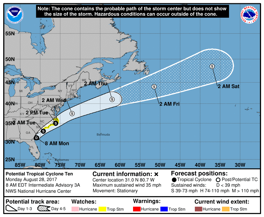 Potential Tropical Cyclone Ten is just off the coast of Jacksonville, Florida, and is expected to become tropical storm Irma during the next 24 hours. This will skirt the coast of the Carolinas, and then track over open water over the Atlantic afterwards. No impact to the U.S.
There is another wave that is just off of the African coast, that has a fair chance of developing. If it develops, it's name will be 'Jose'. We currently do not know where this system may end up. See the Texas Weather Discussion Video for more details. harvey close to landfall in texas, Dangerous Situation For The Southeast Part of the State8/25/2017 Radar Update - Your morning dose of showers and storms this time are located in Parker county and surrounding areas, where a Flash Flood Warning has been issued for parts of Southern Parker and Northern Hood county until 6:45 AM... 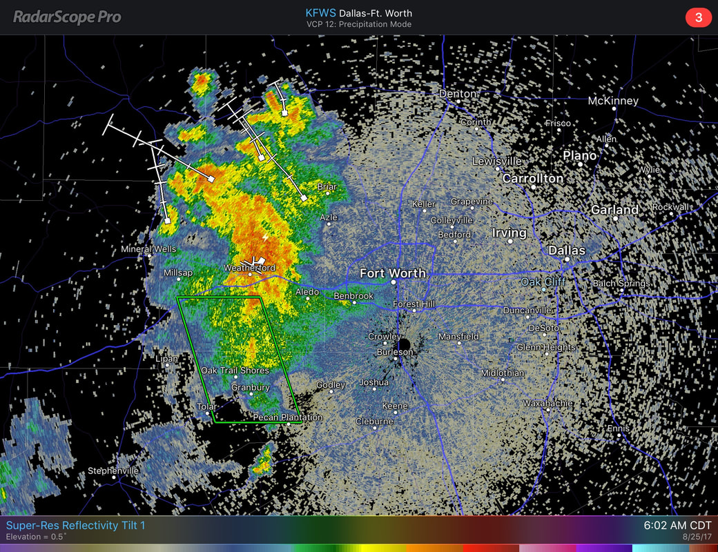 This complex is generally moving to the northeast, non-severe, producing heavy rain and frequent lightning at times. A good dose of clouds is possible today, with highs staying in the upper 80s for most locations. This Weekend - For us, a good supply of unusual dry air tries to seep into the region, limiting the amount of showers and storms about in relation to Harvey. There still will be surging moisture from the Gulf, so scattered showers and thunderstorms is not completely out of the question for the weekend. Expect mostly cloudy conditions with highs in the mid to upper 80s. The Week Ahead - All of next week will ultimately depend on how Harvey will behave, which will take its sweet little time to move. If Harvey drifts more to the north after stalling, it will most likely bring numerous showers and storms to the region Thursday and Friday. If it drifts more to the east, we could very easily stay dry for the latter half of the week. Models are continuing to work out some discrepancies about the placement of the storm, so understand that this forecast could very well change. Otherwise, early next week, we should see a good dose of sunshine with warm temperatures in the upper 80s to low 90s. We can also expect that for much of next week.  Harvey Intensifying Fast - A lot of things has transpired since tomorrow morning. Hurricane Harvey has intensified rapidly now as a strong category Two with max. sustained winds of 105 mph. It is expected to move into the Texas Coast tonight as a major hurricane (category three) with potential for max. sustained winds of 125 mph. This is expected to make landfall near Corpus Christi with significant potential for storm surge and flooding. 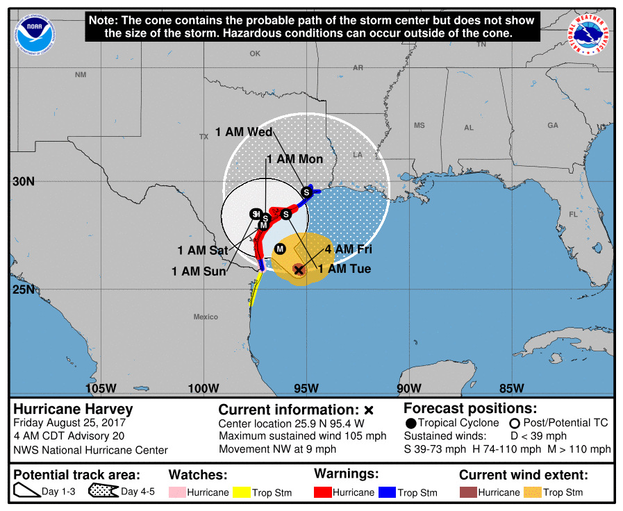 It has been over a decade since a major hurricane made landfall in the U.S.. Previous was Wilma on October 24, 2005. Steering currents in the area will collapse, which will cause Harvey to meander in Southeast Texas through early next week (Tuesday). This will create catastrophic and life-threatening flooding issues with rain amounts of 1-2 feet for the affected area. Not to mention, small, isolated tornadoes are also possible in the feeder bands of this storms. 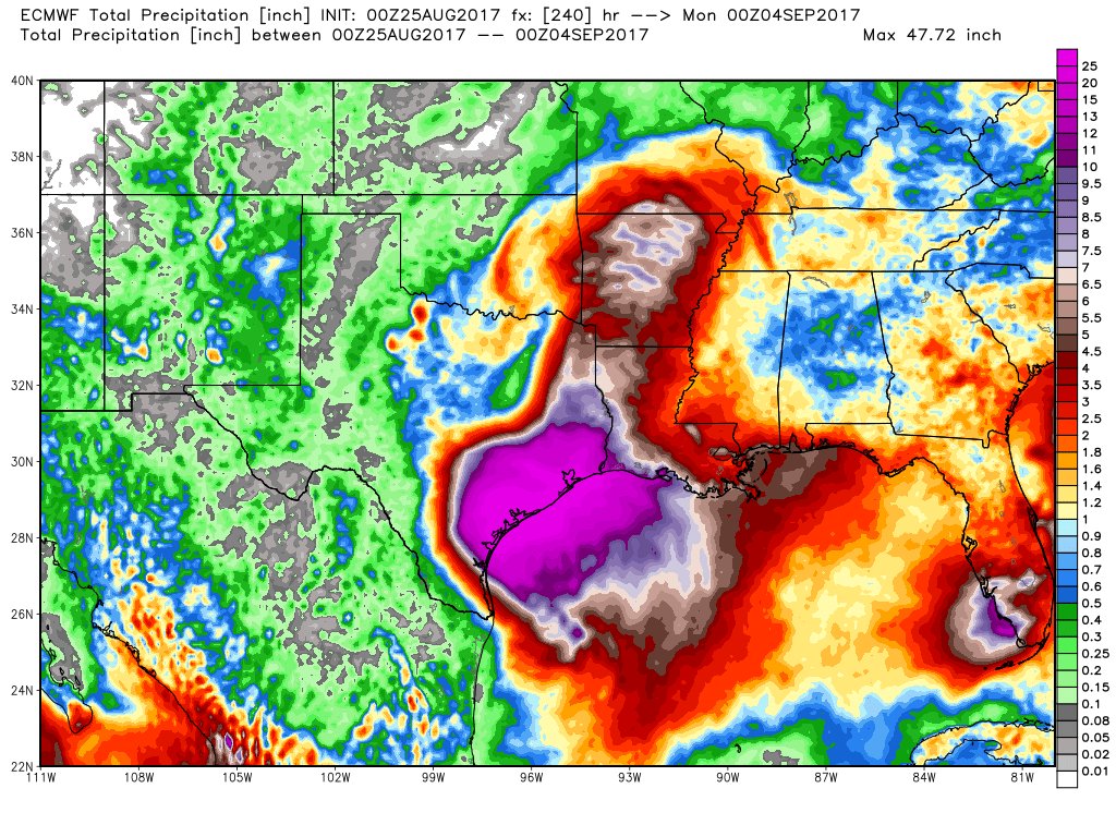 Invest 92L - A disturbance that is still over South Florida will move to the northeast this weekend, heading back into the Atlantic. It has the potential to become Tropical Storm Irma when it gets to the East Coast. The greatest threat for Florida will be heavy rain. No issues expected from this in North Texas. See the Texas Weather Discussion Video for more details.
Radar Update - As most of our time, I start out this post by mentioning our usual batch of showers and storms this morning, to the north and west of DFW. 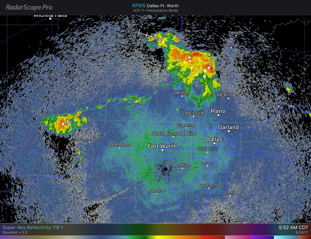 These storms are not severe, and are slowly moving to the north and east. Most locations in North Texas should stay dry this morning, with increasing rain chances this afternoon/evening. This afternoon/evening, due to increased moisture values, we could see scattered showers and storms mainly after 12 PM this afternoon. Due to the random nature of these storms, most locations in North Texas has a 50/50 chance of getting wet this afternoon. Severe weather is not expected, but some storms can produce some lightning and heavy rainfall which may lead to localized flooding. It should stay relatively cloudy for most of the day, with highs in the upper 80s. I expect rain chances to come down by Friday, but just know that we deal with isolated storm chances tomorrow morning as well. Most of the day should remain dry with good cloud coverage and highs in the upper 80s. The Weekend - As moisture levels almost stay the same, we continue to mention the chance for showers and storms for the weekend. These storms are most likely going to be scattered in nature due to moisture levels in association of Tropical Storm Harvey. At this point, our weekend weather will be mostly dependent on how Tropical Storm Harvey behaves, which there is a lot of uncertainty regarding that right now. I do think much of north Texas does have a chance of scattered showers and storms for much of this weekend, but Harvey could make it this week, or later in the week. Model agreement is not too compliant in this case, and will still mention a chance of scattered showers and storms this weekend. 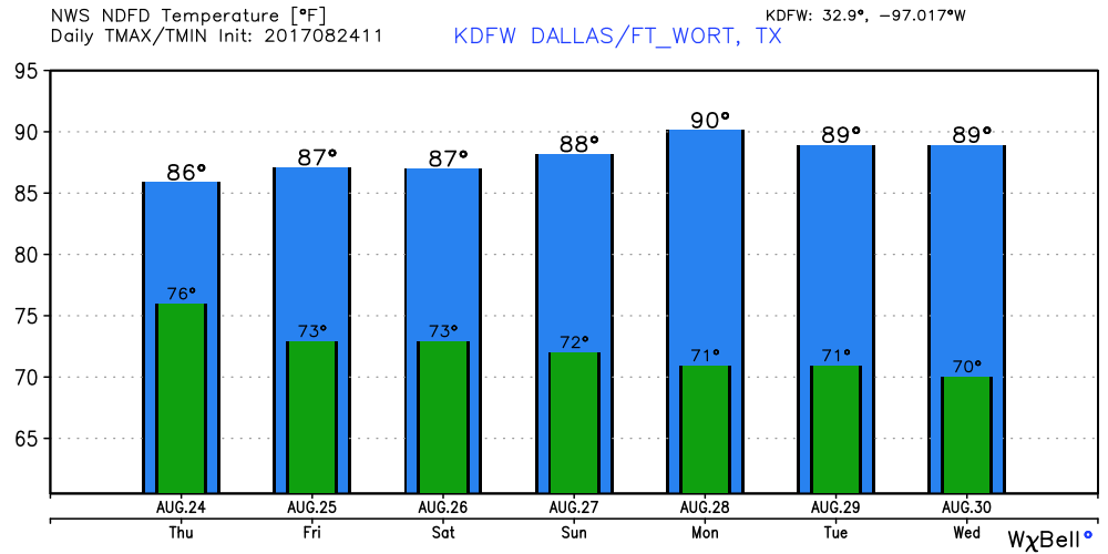 Harvey Expected to Become a Hurricane - The tropical storm in the western part of the Gulf of Mexico is expected to become a hurricane tomorrow afternoon before it makes landfall. Hurricane warnings have already been issued for all of the Middle Texas Coast, and should maintain its strength right at landfall. Hurricane or not, the main issue on the board is heavy rain for this region. Rain amounts of 1-2 feet is likely in southeast Texas, which includes but not limited to Houston and Galveston. This could lead to a significant, and life threatening flooding event. The GFS hints that this could drop 3-4 feet of rain as Harvey stalls around Southeast Texas due to poor steering currents. 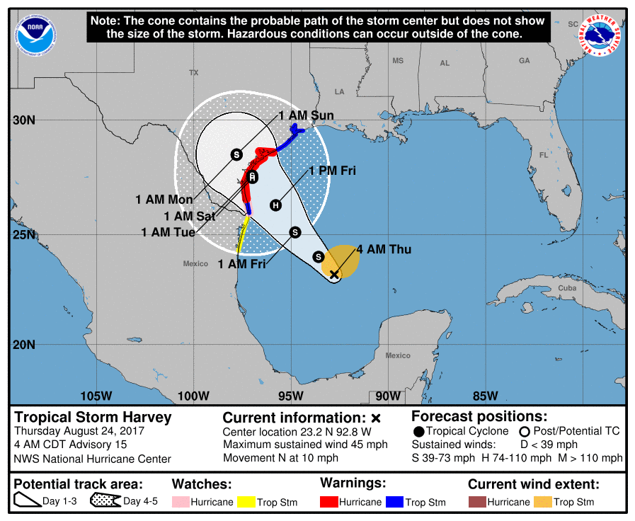 Invest 92L - There is another disturbance in the Florida Peninsula that is bringing heavy rain to the region right now. Slow development of this system is possible this weekend and early next week as it moves northeast back into the Atlantic. If a tropical storm forms, it's name would be "Irma". This will not be a threat to Texas or the Gulf.
See the Texas Weather Discussion Video for more details. Radar Update - As expected, showers and storms are currently ongoing along a surface front, making for a wet commute for some traveling to work and school. 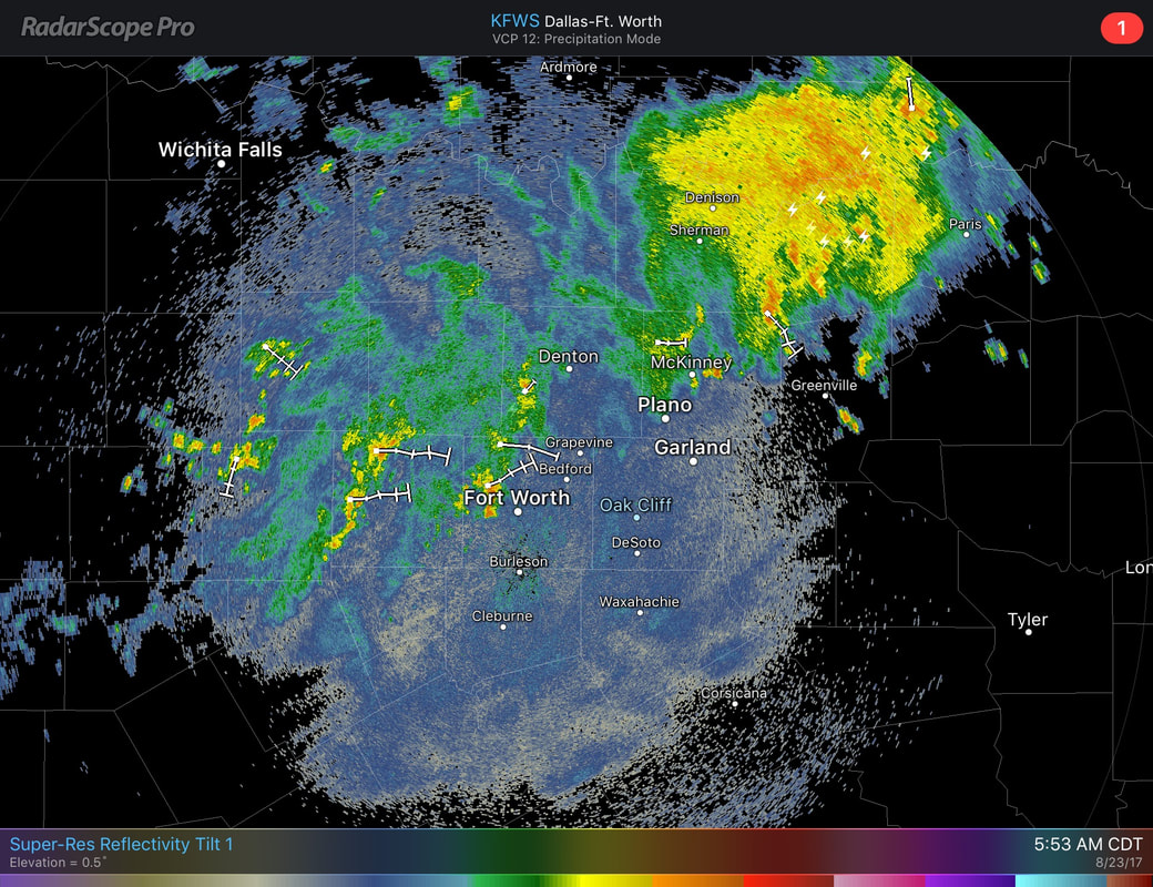 These storms are moving to the east and are not severe, but may produce heavy rainfall and some lightning with the strongest storms. Radar suggests that over 1-2 inches of rain has already fallen between Bowie and Sunset. Aside from the rain, most in DFW are starting the day quiet with highs in the mid to upper 70s. As the surface front gets closer to us, the coverage of rain should be greater by this late morning. Most of us will be cloudy today with highs only in the low 90s. A few scattered showers and storms by the afternoon can't be ruled out. Thursday and Friday - Very subtle differences. On Thursday, we start the day with clouds and cool temperatures. Some cooler places could start their morning with upper 60s for some time. Showers and storms will still be possible on both days, before ultimately tapering off by the end of the day on Friday. The Weekend - Moisture returns, and the chances of showers and storms increase again. We should be accustomed to seeing clouds with highs dropping to the mid 80s. The amount of rain that we see this weekend will be dependent on Harvey, which is a tropical system that is expected to regenerate in the southern Gulf of Mexico in the next 48 hours. Unless we have a definite low-level center, it may be pretty hard to determine where this system may go and which location gets the most rainfall, but things look pretty muggy for this weekend.  Harvey's Back - As you may know, Tropical Storm Harvey dissipated into an open wave while in the Caribbean Sea this weekend, but is expected to intensify tomorrow or Friday. Models suggest that Harvey will move into southwest Texas as a high-end tropical storm/category one hurricane. The main threat to southwest Texas will come from mainly heavy rain and flooding. Models suggest that recurving is likely once it reaches inland, and some parts of southwest Texas, including Houston, could wind up with over two feet of rain during the next several days, which will make for a widespread flooding event.  Invest 92L - A broad tropical low is located on the East Coast of Florida, and should lurk there for a few days, and could develop as the environment becomes more favorable and it tracks out into the Atlantic. If this becomes a tropical storm, it's name will be "Irma". See the Texas Weather Discussion Video for more details.
 Yesterday was great for solar eclipse viewing in North Texas. As expected, the skies were mostly sunny, with only a few clouds. DFW even dropped two degrees at the peak time of the eclipse. This is one of the best photo's I have seen floating across the web. This is from Barry Butler, taken in Southern Illinois... The Rest of the Week - The moisture levels will rise slowly this evening, and showers and storms will be possible during the overnight hours. The greatest chance will be Wednesday evening where a surface front will drop from the north.
Most models suggest that the surface front will stall, and we should mention a chance of afternoon/evening showers and storms. Highs for the rest of the week should struggle to get out of the 80s in most spots. In fact, models suggest that we will continue to see a cooling trend into next week as well with highs struggling to get out of the 80s. No sign of any excessively hot weather as we are reminded about the beginning of metrological fall (September 1). See the Texas Weather Discussion Video for more details. We start the work week (and the first day of school for some) quiet with highs in the mid 80s with several 70s about. There is nothing weather wise that should cause any delays traveling to work and school early this morning. Eclipse Weather - Today is the big day where the most photographed thing in the country takes place - a total solar eclipse. North Texas will be able to see a partial eclipse (75 percent). Weather-wise, it is expected to be perfect for eclipse viewing, with only a few mid-level clouds expected with temperatures in the upper 90s. The eclipse in DFW will start at 11:39-11:40, peak at 1:09-1:10, before ending at 2:39-2:40. Please understand that it is imperative that you do not look directly at the sun without wearing ISO 12312-2 compliant glasses. Failure to do so may lead to temporary or permanent blindness, or serious/permanent eye damage.  For the Rest of the Week - Scattered showers and storms will be possible along a cold front coming from the north, mainly affecting the area overnight on Tuesday and Wednesday morning. The main risk at this point would be heavy rain and frequent lightning, and maybe some localized gusty winds at times. There is a 50/50 chance of one spot getting wet on Wednesday. We should struggle to get out of the 80s due to cloud cover and precipitation. Friday and the Weekend - Early parts of the weekend should be pleasant with mostly sunny conditions with highs in the low 90s, no signs of any excessively hot weather for those few days. We reintroduce a chance of scattered showers and thunderstorms again with mostly cloudy skies on Sunday. Next Week - Not much change. Still pleasant with plenty of sunshine with highs mostly in the upper 80s. No sign of any excessively hot weather anytime soon. See the Texas Weather Discussion Video for more details. 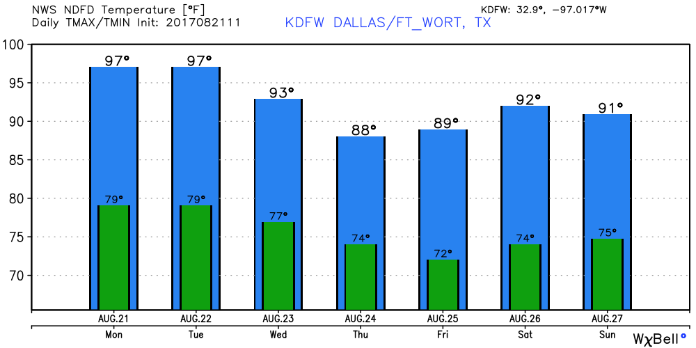 Tropics - Things are not as active as last week...
Remnants of Harvey - Tropical Storm Harvey dissipated this weekend, but re intensification has been evident many times with this system. A tropical cyclone is still possible as it makes it way towards the coast of Belize and the Yucatan Peninsula. Invest 92L - This one is in a harsh environment that is not very favorable for development. However, development of this system is still possible to the north of the Bahamas as it makes its way towards Central Florida or adjacent east coast areas. There is another wave in the middle of the Atlantic Basin that we don't have to worry about due to dry air, shear, and upper-level winds. No Rain this Morning - Showers and storms are nonexistent in North Texas this morning, which is a big difference because some parts in the north received nearly two inches of rain in a time span of an hour. Additionally, temperatures are a tad cooler than yesterday; no 80s on the board as of 5:00 AM. Today will be somewhat similar to yesterday, sunny with clouds out at times with chances of isolated afternoon/evening showers and storms 'randomly'. The best chance of any one spot getting wet will be in the 10-20 percent bracket. Highs should range from 93-98 today. The Weekend - Not much change. Expect mostly clear skies for both days with highs nearing the century mark once again. The humidity values will make it feel even hotter. Just understand that the chance of showers and storms are really low, but not zero, but is less than ten, and will not get mentioned in the forecast. Solar Eclipse Day - A good day is ahead for those who want to watch nature's most awe-inspiring sights. Mostly sunny with only a few passing clouds, and a very small chance of a shower or two during the partial eclipse from 11:39 to 2:39. The high will be nearing 100 degrees again. Also, like I have been saying for weeks, DO NOT look with a naked eye at ANY part of the eclipse. This is still a 'partial' eclipse, and the peak for DFW will come at 1:09 to 1:10 PM. Next Week - We continue to remain dry early next week, but mid-week, a surface front drops from the north, and that will open the door for more scattered showers and storms. The best chance of one spot getting wet is in the 20 percent category, but that will only change with time. 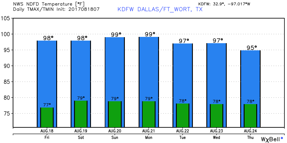 Tropics - As expected near the peak of hurricane season, the Atlantic is getting more active Tropical Storm Harvey - This system is bringing heavy rainfall to the Windward Islands this morning, and it will come across the Caribbean in the next few days before making landfall in Belize and Mexico's Yucatan. As of right now, conditions are not favorable for development, and the NHC precludes from making this a hurricane for now. 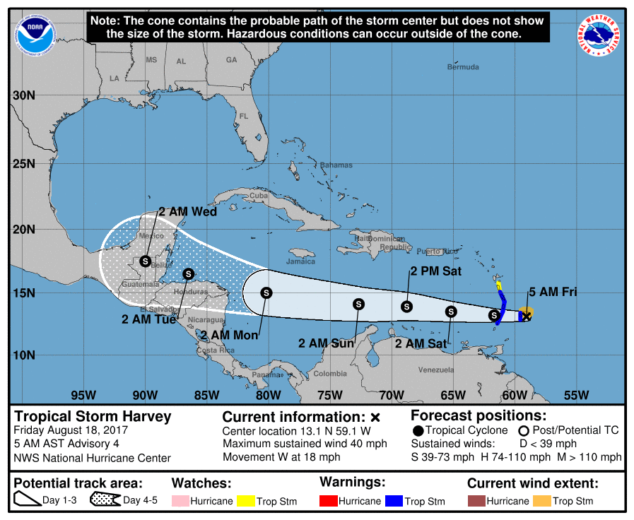 Invest 92L - This one is expected to form into Tropical Depression Ten or Tropical Storm Irma during the next day or so. The modeling brings this near Cuba and the Bahamas for the next few days, but due to harsh conditions, most models die out before it reaches Florida.
The East One - This one is expected to gain latitude. If this does develop, it is expected to recurve into the Atlantic, posing no threat to the U.S. See the Texas Weather Discussion Video for more details. Radar Update - As expected, showers and storms are traveling ahead of a cold front, moving mainly to the east, which may make for another wet commute for DFW. As I am writing this, a Flash Flood Warning is in effect for parts of Denton county until 8:00 AM. 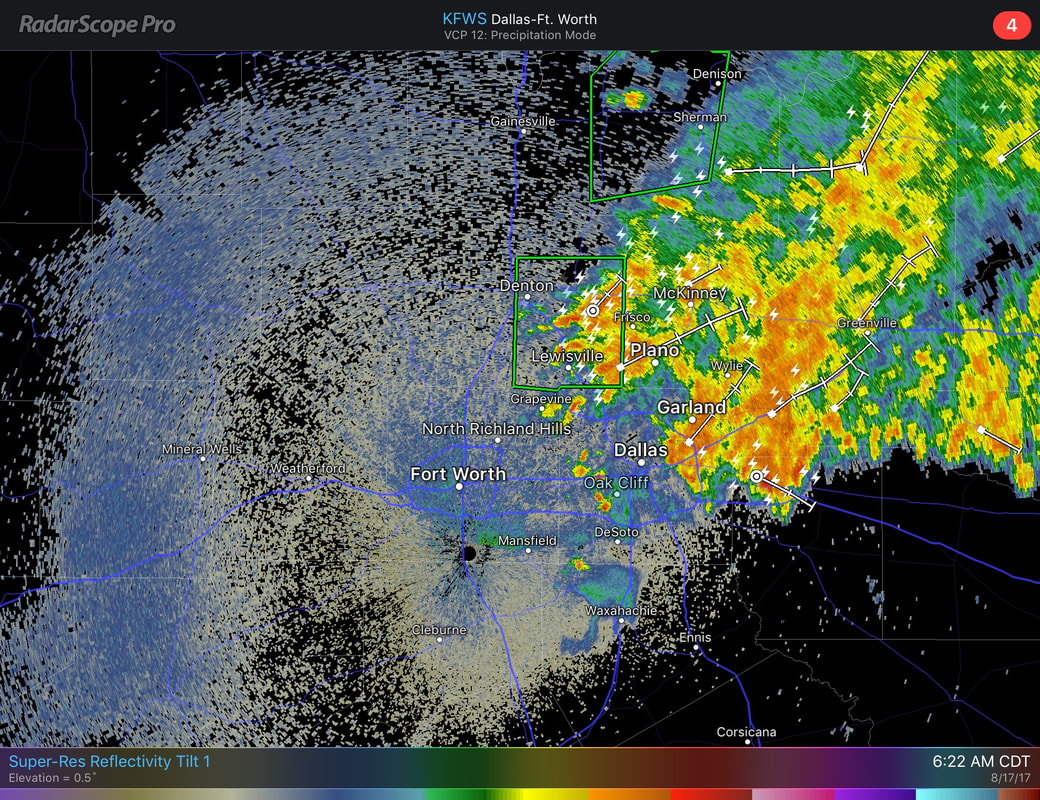 These storms may produce heavy rain, frequent lightning, and maybe some gusty winds. The chance of any one spot getting wet is in the 50 percent range. We will continue to stick with the typical summer forecast with plenty of sunshine with clouds out at times, which a chance of an isolated storm or two during the afternoon/evening hours. We continue with highs in the middle to upper 90s, just what we would expect for the middle of August. The Weekend - Not much change. The cold front is completely out of North Texas, and drier air will take over, leaving a good dose of sunshine with any isolated storms being very limited. Highs will be mostly in the upper 90s to near 100 degrees as the drier air raises the heat levels. Solar Eclipse Information - This Monday, August 21, all of the U.S. will be treated to an eclipse of the sun. Anyone in that is in the path of 'totality' will be able to view one of mother nature's most awe-inspiring looks, a total solar eclipse. This path, where the moon will completely cover the sun and the sun’s tenuous atmosphere – the corona – can be seen, will stretch from Lincoln Beach, Oregon to Charleston, South Carolina. Observers outside this path here in Texas will still see a partial solar eclipse where the moon covers part of the sun’s disk. The eclipse will begin at 11:39, peaking at 1:09, before ending at 2:39 for Arlington. But, what is the weather going to look like for this area? The weather looks like a typical summer day with plenty of sunshine with some clouds out at times, but this does not mean a widespread overcast, which is a good thing. 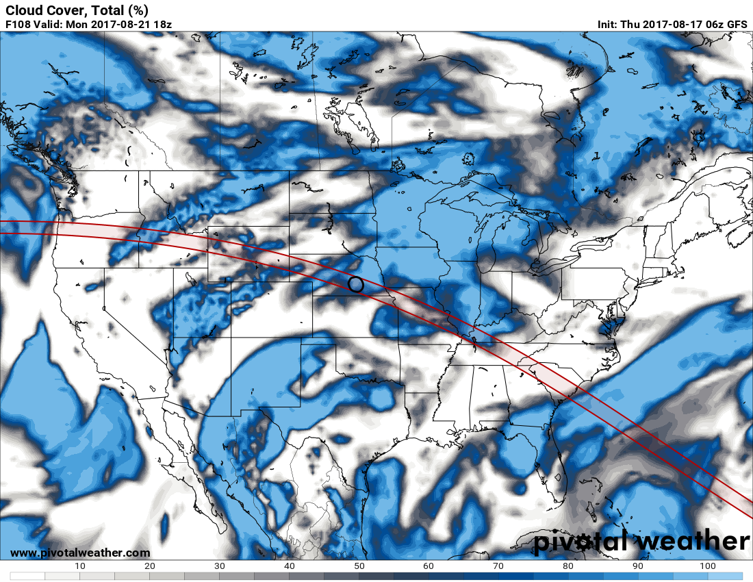 Please be mindful that it is imperative that you are wearing the right eyewear to view this eclipse. More information on that can be found here. Tropical Weather - Gert is now a Category Two hurricane with maximum sustained winds of 100 mph, well to the east of the United States. This is expected to continue churning northeastward in the Atlantic, before becoming post-tropical cyclone this weekend. There are three waves in the African Coast/Cabo Verde Islands region... The first one, Invest 91L, is expected to move towards the Caribbean and Central America, and Harvey would be the name if this were to develop into a tropical storm, quite possibly a hurricane. The second one, Invest 92L, is trying to track into the Bahamas. We currently do not know if this will threaten Florida, the U.S. East Coast, go into the Gulf of Mexico, or recurve into the Atlantic. This will be in a challenging environment, but a tropical storm is still possible. The third one, which is just off of the African Coast, will most likely be tagged "Invest 93L". See the Texas Weather Discussion Video for more details. 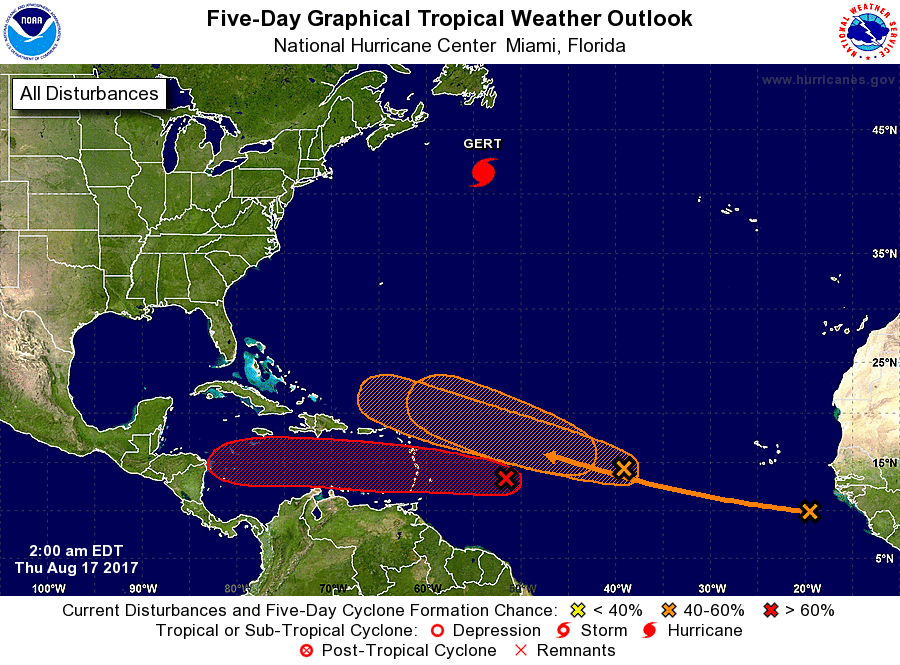 Radar Update - As expected, we have the typical case of morning showers to the north and west of DFW. They are moving to the northeast, and should not leave a huge mess when traveling to work and school. In fact, some rain is not even reaching the ground... 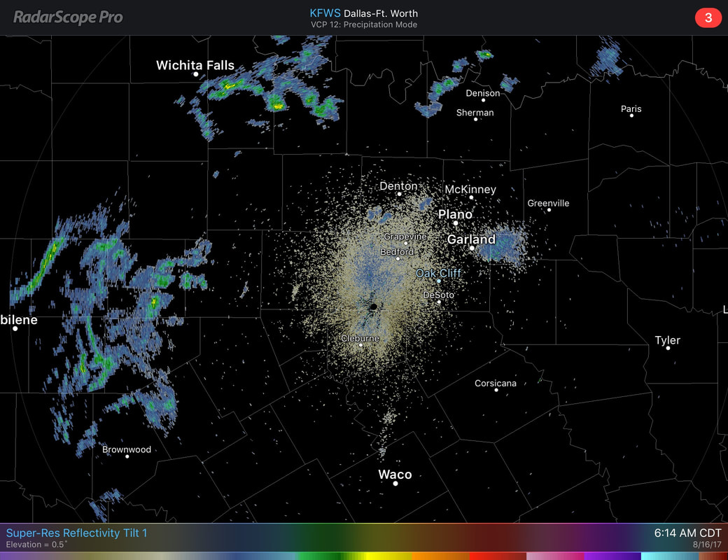 Otherwise, traveling to work and school, things should be quiet with cloudy conditions and highs in the low 80s, warming to the mid and upper 90s today. For the Rest of the Week - Not much change. A cold front tries to slide through tomorrow, bringing at least slightly better chances for showers and storms on Thursday. The best chance for any one spot getting wet is in the 20 to 30 percent range, mainly in the afternoon/evening hours. Otherwise, expect a mix of clouds and sun with highs in the mid to upper 90s again. The Weekend - Things should trend a little drier. Any showers and storms should be less in number, with sunshine back in full force with highs in the upper 90s at the Upper High makes its debut. Solar Eclipse Weather - A new post will be available later today to detail the weather forecast, and much more about the eclipse. Tropics - Things are starting to get active. Hurricane Gert is past the outer banks of the Bermuda, moving northeast towards North Atlantic with maximum sustained winds at 90 mph, and should pose no threat to land. Invest 91L has a good chance of becoming Tropical Storm Harvey in the next few days. Models bring it towards the Caribbean, and into Central America, but does not look like it will be a threat to the Gulf of Mexico. Invest 92L is a higher latitude system that could develop as well. Models pass it due north of the Carribean, again, posing no threat to the Gulf of Mexico. There is another wave just off the coast of Africa that we will worry about with time. See the Texas Weather Discussion Video for more details. 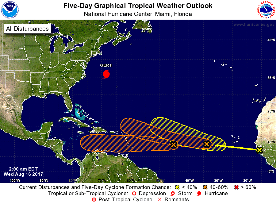 Look for the next forecast by me by 6:00 A.M. tomorrow morning.
Make it a great day! Radar Check - Some of the thunderstorms that were in the Texas Panhandle yesterday evening are now in parts of North Texas this morning, bringing potentially heavy rainfall in some spots, and some lightning. 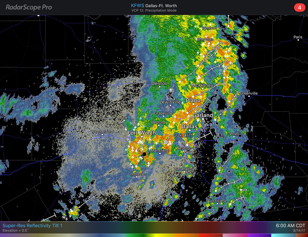 These storms are not severe and may affect the morning commute for those heading to work and school. Moving to the northeast, this is expected to taper off by late morning. Despite all of the rainfall and clouds, it will still be hot and humid out there, with highs in the middle to upper 90s. The rain should clear by the afternoon to evening hours. Mid-Week/First Days of School - Not much change. Conditions are expected to be hot and humid with highs in the upper 90s nearing 100-degrees. There is a chance that we could see another chance of an isolated shower or two by Wednesday or Thursday as a surface low is northeast of here and a cold front pushes to the west. The Weekend - We still stick with the typical, summer forecast with bright and sunny skies with highs nearing 100-degrees. The latest NDFD tried to have DFW 97 all week, but I think some days will be slightly cooler and hotter than that. Saturday might be another look at a shower or thunderstorm, but mostly all locations will stay dry this weekend. SOLAR ECLIPSE DAY - I purposefully stalled to put this here due to the fact that there is really no skill trying to predict the weather past ten days. It will be very sunny with highs nearing 100 degrees again. With mostly sunny and hot conditions, the solar eclipse should be visible for most of the DFW area. See the Texas Weather Outlook for more information. 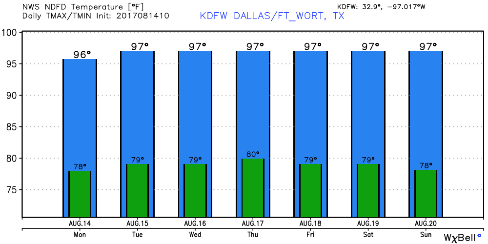 Tropical Storm Gert Forms in the Atlantic - After watching this system for several days fighting dry air and shear, this finally formed to Tropical Storm Gert, and is expected to strengthen into a hurricane by Wednesday evening. This should not have any impacts on the U.S., as it is expected to recurve back into the Atlantic. 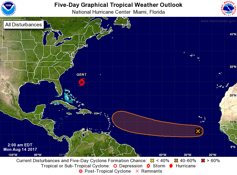 There is another disturbance near the Cabo Verde Islands, that is in the process of organizing itself. Nothing is expected for the next 48 hours, but there is a 50/50 chance that a tropical storm will develop as it tracks near Puerto Rico.
Have a great day. Outflow Boundary This Morning - Some areas around the DFW area saw a remarkable outflow boundary this morning, along that, pockets of brief heavy rain fell.  Aside from the rain, most locations are currently near the century mark again today, with DFW Airport just barely off reaching 100 degrees. In terms of climatology, we are below average on 100 degree days, and I would like to keep it that way. Chance for Severe Weather North of DFW - Showers and thunderstorms will be possible ahead of a stalling surface front. With that, the Storm Prediction Center currently has areas to the North of I-20 in the standard "slight" risk for severe weather. 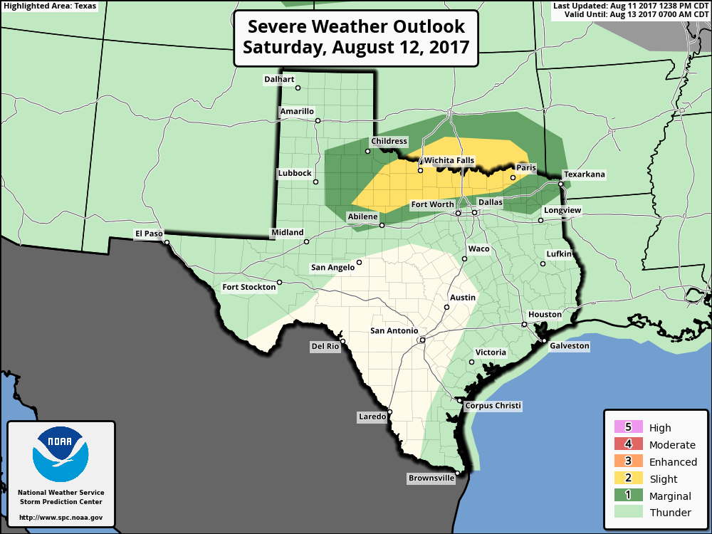 The main concerns right now are damaging straight-line winds, but a tornado or two can not be ruled out. Most of DFW may see some rain, but organized severe weather shouldn't be an issue for the greater metropolitan area. The risk for rain should also continue into Sunday morning as well into the overnight hours, but no severe weather is expected. Otherwise, expect partly to mostly cloudy skies with highs in the mid to upper 90s for the weekend. Next Week - The slight chance for showers and storms still exists as the surface front stalls just to the north of the TX/OK border early next week. The best chance of one spot getting wet is in the 20-30 percent bracket. Otherwise, expect mainly cloudy conditions with highs in the mid 90s again. MISD's First Day of School - As the front fizzles out, the temperatures should start to increase, and the cloud coverage should be limited. Most of us should continue to stay hot with highs in the mid to upper 90s, almost nearing the 100s, which is just about average for this time of the year. See the Texas Weather Outlook for more details. 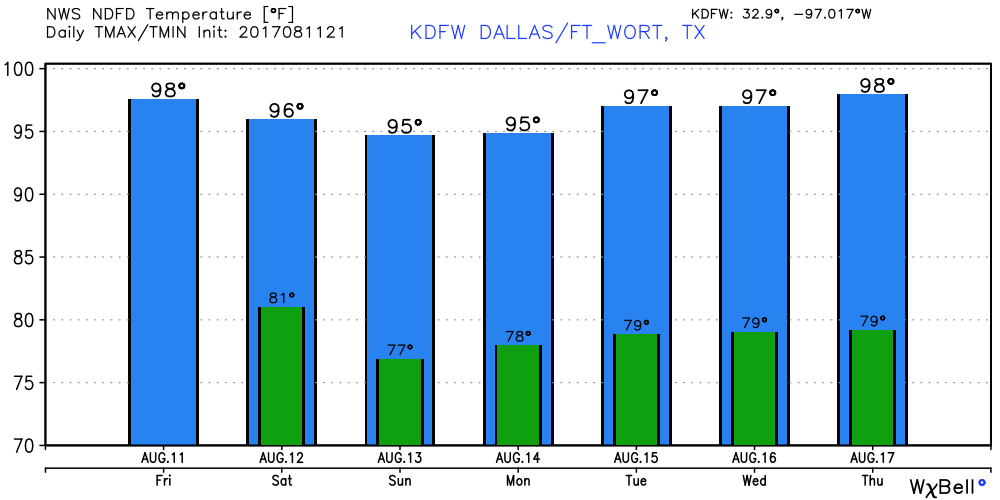 Tropics - There is one disturbance near Florida's east coast bringing heavy rain, but is not expected to develop anytime soon. Meanwhile, Invest 99L is continuing to show signs of development. As of now, it is in a much better environment for development as there is less shear involved. The NHC gives it a 50/50 chance of developing during the next five days. If it develops, it is expected to recurve into the Atlantic Basin, posing no threat to the U.S. 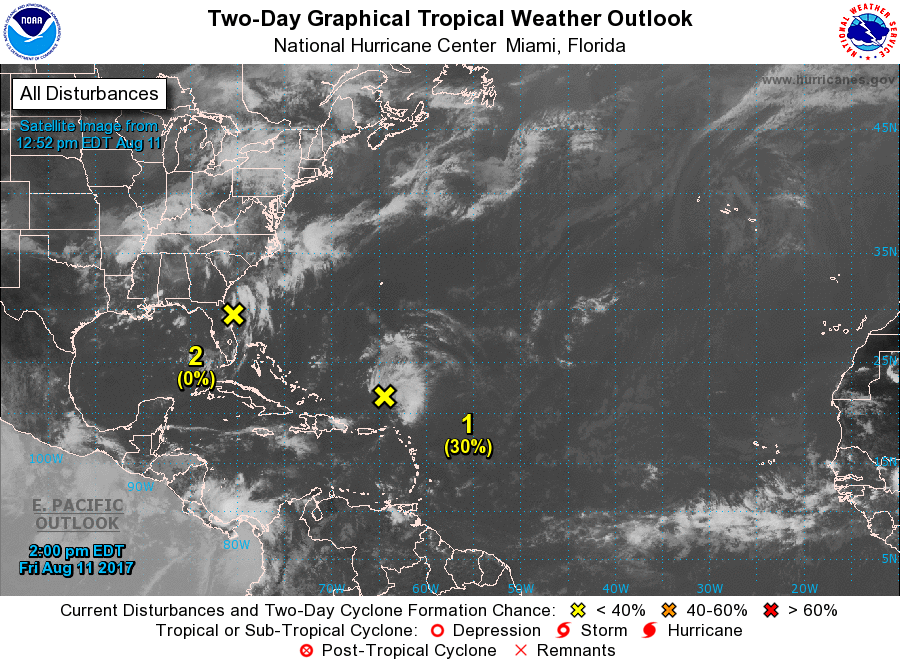 Next post will be Monday morning.
Have a great weekend. Radar Update - Showers and storms have developed to the south of Ennis, and are expected to slowly drift off to the southeast.  Storms may produce brief heavy rain and some lightning at times, but no severe weather is expected. If any rain, the highest coverage will be to the south and east of DFW. For most of us, we should continue to enjoy sunshine with clouds out at times and highs in the middle to upper 90s. Tomorrow and the Weekend - Not much change when you talk about Friday and Saturday. An upper-level high to the southwest should keep us hot and humid for the next few days with highs in the upper 90s with heat indices in the 100-degree range. By Sunday, a surface front drops from the north which should give us more chances of showers and storms with slightly cooler temperatures, which we will start to notice by Sunday evening. Otherwise, the weekend should be clear with highs in the middle to upper 90s again with plenty of sunshine. Next Week - Monday and Tuesday will be the best chance for showers and storms for a while due to moist air coming from the surface front from the north. I can't be specific about when it could rain, just know that we have a chance both days. We should struggle to get out of the 80s for these days due to the amount of cloud cover and rain. Going forward, we should have drier air and temperatures should warm back up to the middle to upper 90s. See the Texas Weather Outlook Video for more details. 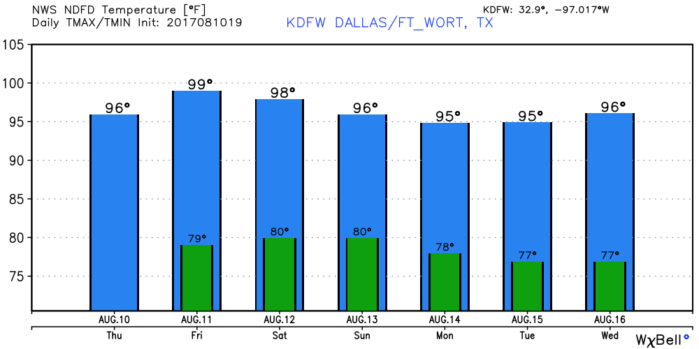 Tropical Talk - Hurricane Franklin dissipated to an open wave as soon as it made landfall for the second time. Invest 99L is still northeast of the Leeward Islands, and some development is possible once it gets into a better environment. If it develops, it is expected to recurve back into the Atlantic Basin, posing no threat to the U.S.. There is one more disturbance near Miami and the Bahamas, expected to produce heavy rain in those areas but is not expected to develop. 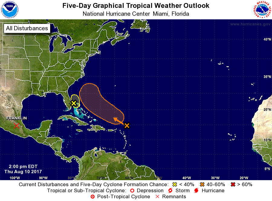 Have a great rest of the day.
Time To Pull Out Those Shorts - Today will continue to be an average summer day, with highs in the low 90s. But, an upper high to the south of us should make for a hotter and drier airmass than recent days. I think that should last for only a short period of time. Tomorrow and Friday - Back to what I was saying about the upper high, not much changes will be made to the forecast both of these days. We will continue to remain in a dry air mass with highs in the upper 90s. In addition, with the humidity starting to increase along with the temperatures, so do the dewpoints. So, heat indices are expected to be in the 100-degree bracket for both days. If we do see rain, it will mainly be to the east of us in the form of an occasional isolated shower or storm. The Weekend - The same pattern sticks around on Saturday, until a surface front drops from the north. With this, things should cool down a tad by Sunday with a chance of scattered showers in storms, mainly in the afternoon and evening hours. Otherwise, you can expect highs in the middle to upper 90s this weekend. Next Week - Early next week, as the surface front comes more to the south, that will bring better chances for scattered to perhaps numerous showers and storms early next week. The best chances will be on Monday, where we will have a good amount of cloud cover, and we should struggle to get out of the 80s because of that. Rain chances will continue to exist until we get to Wednesday, where things are expected to be clearer and drier. See the Texas Weather Outlook for more details. 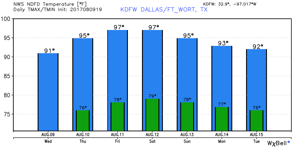 Tropical Storm Franklin on the Verge of Becoming a Hurricane - At 1PM, it continues to have maximum sustained winds of 70 mph while coming through the Bay of Campeche, and is expected to become the Atlantic's first hurricane this year before it makes landfall in the Mexican Coast, well to the south of Brownsville, Texas. Invest 99L - This tropical wave is currently fighting a lot of dry air and shear right now, but, if it can move out of that environment, then it may have a fair chance of developing during the next five days. The NHC currently has a 50/50 chance of development during the five day period. 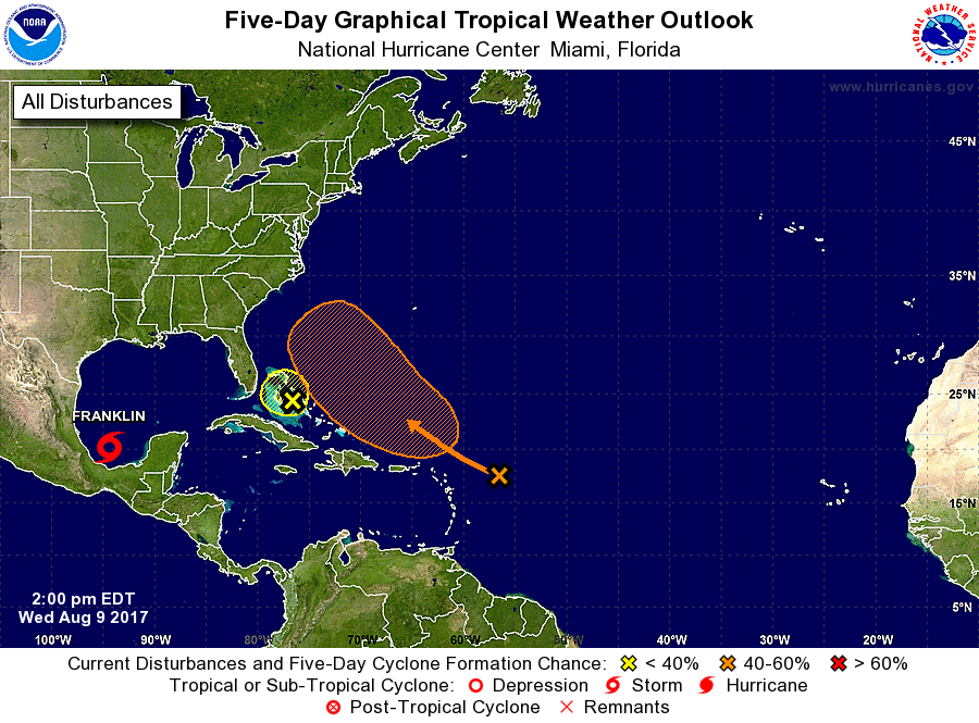 Have a great rest of the day.
A surface front that brought some heavy rains this weekend is now to the south, and behind that is drier air, which has in term kept rain to a minimal and dewpoints down, you still can't rule out the chance for an isolated shower or two as some tropical moisture still exists. I doubt that we will get into the mid 90s due to cloud coverage. For the Rest of the Week - The surface front to the south will dissipate, and an upper-level high moves to the northeast, which should keep things drier and just a little hotter for the rest of this week. You still can't completely say no a shower or storm, but on the bright side, I don't expect and 100-degree weather for a long time, which makes these temperatures below average for this time of the year, which I am not complaining about. The Weekend - Broad troughing in the North will allow a surface front to drop from the south, creating more chances for showers and storms mainly on Sunday. I don't think this will be another widespread rain event for now, but some locations could see some areas of heavy rain at times. Otherwise, expect to be in the middle 90s for the weekend, with things just a tad cooler on Sunday. The surface front won't bring down temperatures, but it should create more rain chances. Next Week - The chance for showers and storms will still exist Monday and Tuesday as the front stalls. I think the better chances for widespread rain will exist during Monday. The GFS shows an upper-high starts to build in the deep south, and if that verifies, the weather will trend drier and hotter. But, this is ten days out, and could very well change a lot. See the Texas Weather Outlook Video for more details. 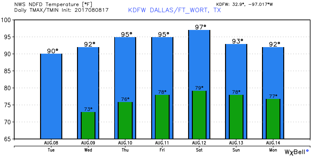 Tropical Storm Franklin is Inland Now - Tropical Storm is Island in the southern tip of Mexico with maximum sustained winds at 40 mph, and is expected to come through the island of Campeche tonight before going back into water temporarily, where some intensification is possible. After that, it will make second landfall over the Mexican coast, staying well to the south of Brownsville, Texas. There is still the chance that this becomes the first hurricane in the Atlantic. 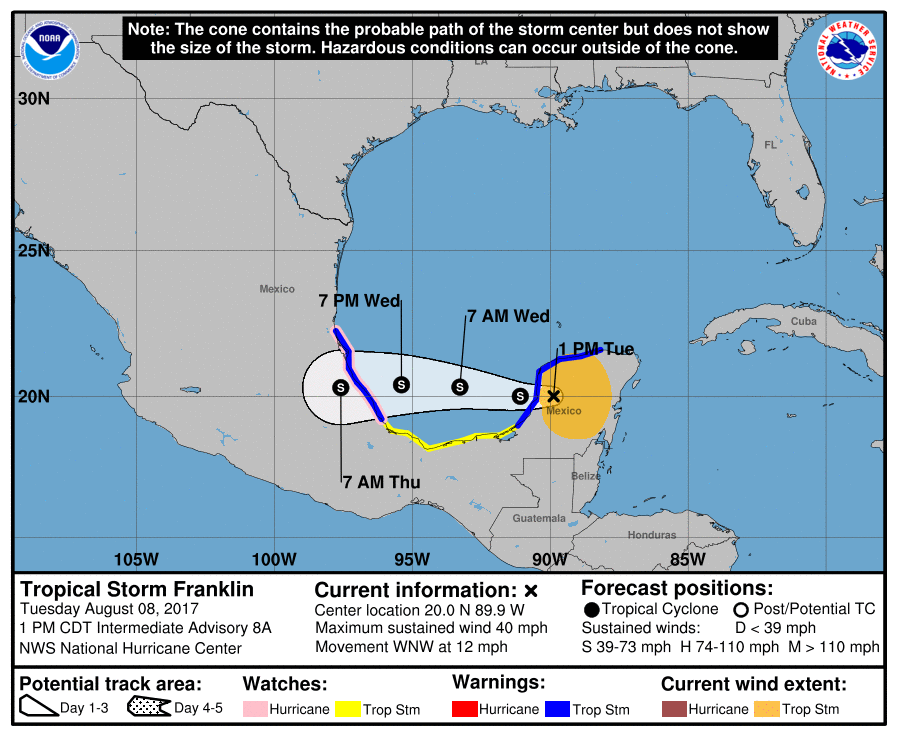 There is another tropical wave in the middle of the Atlantic Basin, which is fighting a lot of dry air and a lot of shear, which is heading northwest. There is a likely probability that this does not develop.
-Donovan Neal- Today should be a little warmer and drier than yesterday. No widespread heavy rainfall is expected until we get to Sunday and Monday, which I will talk more about. Highs should stay in the low 90s in most spots, if any rain occurs, it will most likely be in the form of an isolated shower or storm. It should also be less cloudy than yesterday. DFW Airport recorded a temperature of 77 degrees at 4:51 AM. Friday and the Weekend - On Friday, a cold front will continue to progress from the north, which may bring a chance of scattered showers and storms, although I should mention that it will not be like yesterday. The best chance of one spot getting wet is in the 20% range. Saturday almost has the same forecast with a few scattered showers and storms with highs in the low 90s. This will not be a downpour. By Sunday, moisture values start to increase even more, as well as rain chances. This day should see more widespread rain than on any of the previous days with highs in the upper 80s to low 90s with clouds out at times. Next Week - Monday may be another wet day with a 60 percent chance of one spot getting wet. Scattered to numerous showers and storms appear possible yet again with cloudy conditions through most of the day with highs in the upper 80s. Going forward by Tuesday, the best chance of getting wet will be in the 30-40 percent range all of next week. Expect highs in the upper 80s to low 90s with clouds definetly out at times. Glad to say that during the hottest part of summer. See the Texas Weather Outlook Video for more details. 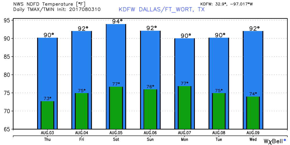 Tropical Talk - Tropical Depression Emily is no more; it dissipated to an open wave yesterday. However, there is something to watch near the African Coast, where both the GFS and the European depict a tropical system over the Atlantic Basin, making its way westward towards the Caribbean Sea. Of course, the timing of both models are in disagreement, but, the NHC gives this a 50% chance of becoming a tropical storm during the next five days. 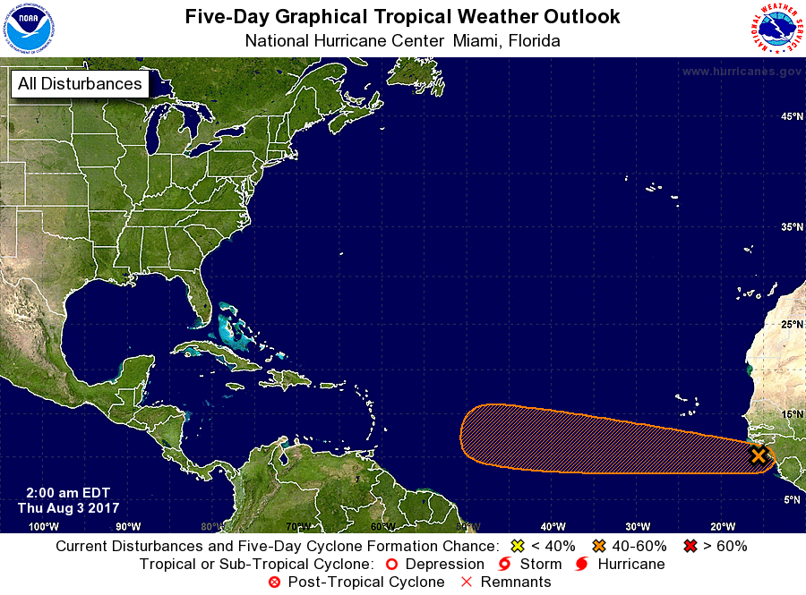 Have a great day.
Donovan Neal RADAR CHECK - As you head out this morning, you might want to pack an umbrella. Showers and storms are moving ESE across North Texas, with stronger cells along and south of I-20 and well to the east of I-35. 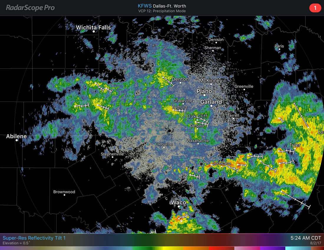 They are expected to continue moving slowly to the east, bringing downpours in some locations. Severe weather is not expected, but some stronger cells may produce frequent lightning or gusty winds. Rain should end by the afternoon/evening hours. Scattered to numerous showers and storms are expected across North Texas for much of this morning before clearing in the afternoon. It should be cloudy for most of the day, with highs only in the upper 80s due to cloud coverage. The chance of one spot getting wet this morning is in the 60-70 percent range. Tomorrow should stay mostly rain-free with highs in the low 90s with clouds out at times. But, you can never rule out the chance of an isolated storm or two during the afternoon hours. Friday and the Weekend - Same, consistent forecast will stick with us during the weekend. Cloudy, with at least SOME chance of showers and storms each day with highs in the low 90s. Not everyone will see rain. The best chance of one spot getting anything is in the 20 percent range Friday and Saturday. Sunday, scattered showers and storms will be more likely along a cold front coming from the north, and that should raise storm chance by 20 percent. Next Week - As we start of the early week, the cold front should still stick along a cold front, mainly on Monday where the chance for rain will be the highest next week. Mostly cloudy, with chances for scattered to numerous showers and storms. Just like today, highs should only stay in the upper 80s due to the cloud coverage. During the latter half of the week, storm chances should slowly start to come down with highs in the low 90s. I don't say that too often during the hottest part of the summer. See the Texas Weather Outlook for more details.  A little hotter than yesterday, we are already starting the day out mild. At 5:00 AM, DFW Airport recorded a temperature of 80 degrees this morning. Surrounding locations are in the 70s, warming up to the upper 80s to low 90s later today. We are dry now, but we can't rule out the chances of scattered showers and storms during the afternoon/evening hours. These showers will be ahead of a complex of rain moving northwest out of North Texas. The best chance of one spot getting wet is in the 20% category, but if you don't see anything today, don't worry, there will hopefully be much better chances Wednesday morning. Mid-Week - Wednesday seems to be a really good chance for showers and storms here in North Texas, mainly in the morning hours. Models continue to indicate that a complex of showers and storms will move from the north, bringing some downpours, lightning, and some gusty winds at times. The good news is that I am not expecting severe weather, but it could get windy. There is a 50-50 chance of one location getting wet. After Wednesday, things should be much drier as we finish the work week. There still will be a chance for a shower or storm, but widespread rainfall should not be an issue after this time. Mainly in the afternoon and evening hours, the chance of one spot getting wet is in the 20-30 percent bracket. Otherwise, expect sunny skies with clouds out at times, and highs ranging from 90-93. The Weekend - Saturday looks like a dry look with highs in the low 90s. You can never rule out the chance for a shower or storm this day. Sunday, we could see scattered to numerous showers and storms mainly during the afternoon and evening hours, but it will not be a washout. Otherwise, expect partly cloudy conditions with highs in the low 90s. This will feel good, especially, climatologically speaking, the hottest part of summer. See the Texas Weather Outlook Video for more details.  Tropical Talk - There is only one thing to talk about in the Atlantic Basin, and that is Tropical Depression Emily (formally tropical storm). At this time right now, it appears that it will no longer affect the US after it gets out of Florida, and should continue living in the Atlantic Basin. Here is the official NHC track. 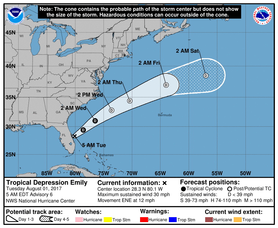 Have a great day today.
Donovan Neal |
Archives
April 2024
Categories |
 RSS Feed