
|
Time To Pull Out Those Shorts - Today will continue to be an average summer day, with highs in the low 90s. But, an upper high to the south of us should make for a hotter and drier airmass than recent days. I think that should last for only a short period of time. Tomorrow and Friday - Back to what I was saying about the upper high, not much changes will be made to the forecast both of these days. We will continue to remain in a dry air mass with highs in the upper 90s. In addition, with the humidity starting to increase along with the temperatures, so do the dewpoints. So, heat indices are expected to be in the 100-degree bracket for both days. If we do see rain, it will mainly be to the east of us in the form of an occasional isolated shower or storm. The Weekend - The same pattern sticks around on Saturday, until a surface front drops from the north. With this, things should cool down a tad by Sunday with a chance of scattered showers in storms, mainly in the afternoon and evening hours. Otherwise, you can expect highs in the middle to upper 90s this weekend. Next Week - Early next week, as the surface front comes more to the south, that will bring better chances for scattered to perhaps numerous showers and storms early next week. The best chances will be on Monday, where we will have a good amount of cloud cover, and we should struggle to get out of the 80s because of that. Rain chances will continue to exist until we get to Wednesday, where things are expected to be clearer and drier. See the Texas Weather Outlook for more details. 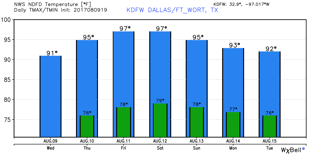 Tropical Storm Franklin on the Verge of Becoming a Hurricane - At 1PM, it continues to have maximum sustained winds of 70 mph while coming through the Bay of Campeche, and is expected to become the Atlantic's first hurricane this year before it makes landfall in the Mexican Coast, well to the south of Brownsville, Texas. Invest 99L - This tropical wave is currently fighting a lot of dry air and shear right now, but, if it can move out of that environment, then it may have a fair chance of developing during the next five days. The NHC currently has a 50/50 chance of development during the five day period. 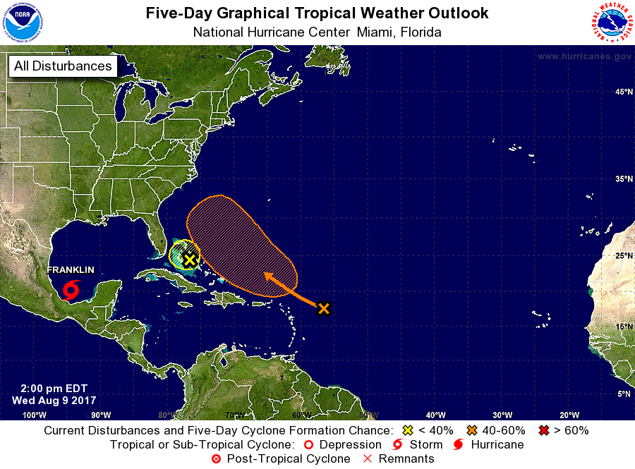 Have a great rest of the day.
|
Archives
March 2023
Categories |
 RSS Feed
