
|
Cold Start - Many places are just above the freezing mark this morning across North Texas, and we project a high in the 65-70 degree range in most spots today. A few mid and high level clouds will be possible due to a jet stream wave approaching, but we will continue to stay dry with no rain expected this week. We remain sunny and dry to finish the week. Friday Through Weekend - The weather will continue to be dry through the weekend with cool nights and pleasant days with abundant sunshine. We start the days mostly in the 50s, warming to the low 70s. Football Weather - For the high school playoff games Friday evening, the game should be played under a clear sky with temperatures falling through the 60s. Highland Park hosts Mansfield Summit High School at SMU's stadium (kickoff @ 7:30p). The game will be played under fair conditions with temperatures falling into the low 60s during the game. Next Week - As we get closer towards early December, it is now starting to become evident that a big pattern change will take place. First, a cold front will bring a batch of scattered showers and thunderstorms as early as Monday evening. A few of the storms may be strong, but no signs of any major severe weather issues anytime soon. As that happens, a deep trough sets up in the eastern part of the U.S., which will send down the coldest air thus far in the season starting Wednesday with highs mostly in the low 50s and lows in the mid to upper 30s. See the Texas Weather Discussion Video for more details. 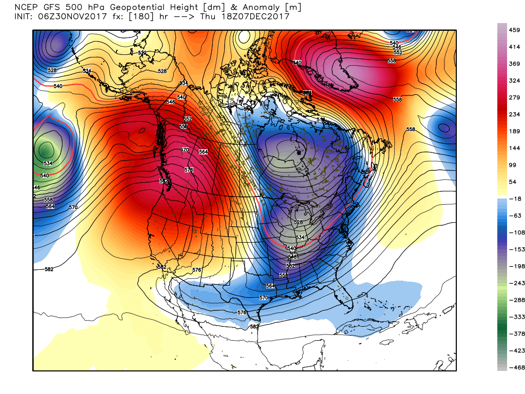 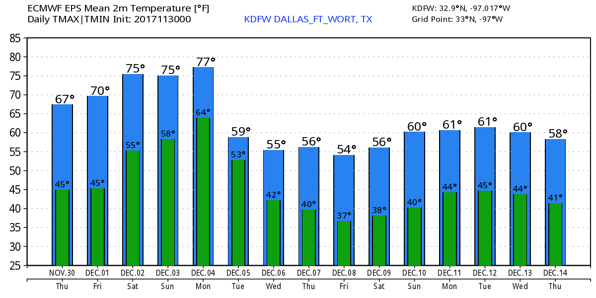 Cold Front - For the communities in front of the cold front, it is just another mild morning with temperatures in the mid 50s in the metropolitan areas. For the places in the back of the front, it is a chilly morning with temperatures in the mid 50s. It will be fair at sunrise, and we should warm nicely to the mid 60s this afternoon, 10-15 degrees below yesterday's temperature. The average high for DFW on November 29 is 61 degrees. Clouds will decrease a little as the shortwave trough passes, but we should continue to be dry with highs in the mid 60s for tomorrow. Friday Out - We continue to remain dry Friday and the weekend with abundant sunshine. Highs should be in the upper 60s on Friday, but we trend warmer during the weekend with highs in the low to mid 70s. Football Weather - The weather should be absolutely perfect for the high school playoff games Friday night; A clear sky with temperatures falling to the low 60s. Summit High School takes on Highland Park at SMU (7:30p kickoff). The sky will be fair with highs in the mid 60s throughout the game. Next Week - There is very little run to run consistency, but overall, the models have a pretty good idea. Both models push a new surge of cold air into the state on Tuesday, followed by a chance of scattered showers and thunderstorms during the day in the middle of next week. The upper trough swings by during the middle of next week, and makes itself comfortable in the east due to the blocking pattern. That being said, we could have multiple cold spouts as we go through December. Too early to be specific, but just an idea. See the Texas Weather Discussion Video for more details. 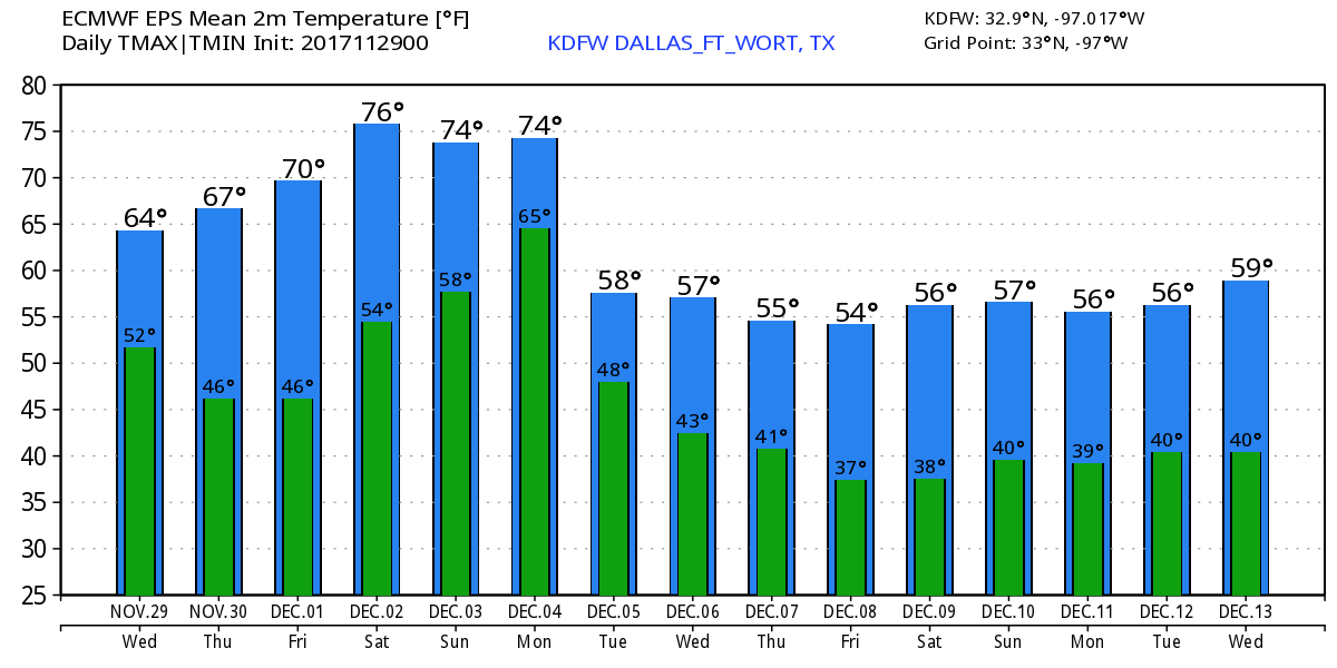 Quiet Morning - It is another quiet morning across North Texas with temperatures in the mid to upper 50s. With a mix of sun and clouds, we should warm nicely to the mid 70s this afternoon. Still about 10 degrees above average; the average high for DFW on November 28 is 62 degrees. It may be breezy at times, but will continue to remain very pleasant. Wednesday and Thursday - Clouds start to increase as a cold front pushes through the area, but should come in a dry fashion. This front will bring temperatures down to the mid 60s in most spots on Wednesday. For Thursday and Friday, we continue to forecast a sunny sky with highs in the mid 60s, excellent weather for the high school playoff games on Friday. No signs of any precipitation this week. The Weekend - No real change; We still remain very sunny and pleasant with highs in the low 70s with lows in the 50-60 degree range. Next Week - The GFS suggests that a band of numerous showers and storms will push through the region from Wednesday to Thursday evening. No signs of severe weather, but this could mean our first real chance of rain in a while. Cooler air will also follow next week, with highs in the mid 50s and lows at or just above the freezing line. See the Texas Weather Discussion Video for more details. 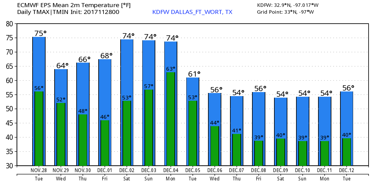 Comfortable Morning - Temperatures early this morning are in the mid 50s in the major metropolitan areas, 40s to the east of I-35. However, we warm substantially with abundant November sunshine. The high this afternoon will be in the mid 70s. Sunny weather and breezy conditions continue with a high in the mid 70s with westerly wind at 20 mph. Wednesday Out - A cold front comes in by dry fashion on Wednesday, although clouds will begin to increase for those two days. Moisture will be too limited to support any rain development for this week, so we will continue to remain dry with highs in the mid 60s on both days. Some of the naturally cooler spots will start the day in the upper 30s. Friday is also dry with a clear sky with the high in the 60-62 degree range. Excellent weather for high school playoff games continuing. Next Week and Out - The weather continues to remain quiet for the first two days of next week, but we could be dealing rain and storms through the latter half of next week with the progression of a cold front and a vigorous upper trough. There is clear evidence that a pattern change will likely occur over the next 10-16 days with the progression of an upper-level trough that could set up over the Central and Western portion of the U.S. This could bring considerably cooler air to North Texas, with highs in only in the mid to low 50s with lows in the upper 30s. This could also bring storm chances to the Central U.S as well. 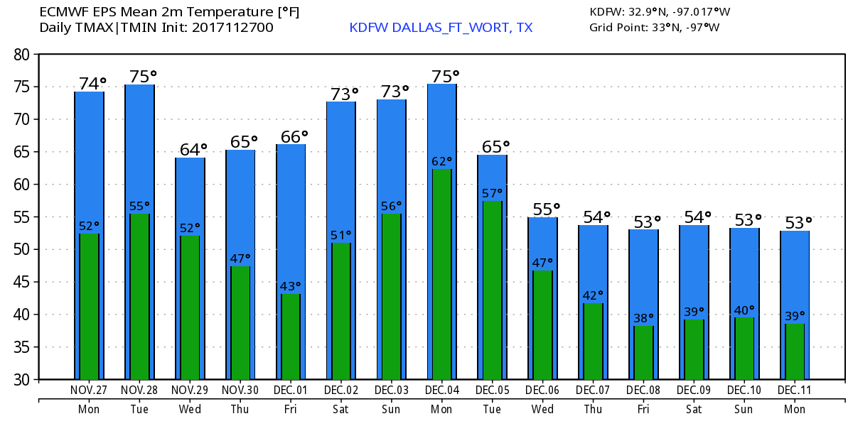 Keep in mind that we are still in our late severe weather season, which means severe weather is still possible even in December. Also, we do note that the European model ensemble suggests that we could see up to 3 1/2 inches of rain from December to January 10th. Still no skill in a specific forecast past ten days, but we will need any rain that we can get.  Tropical Season Comes to a Quiet End - The 2017 Hurricane Season in the Atlantic ends this Thursday, and we remain quiet today.
Mild Start - Temperatures are mostly above average this morning with most places in the 65-71 degree range. We warm into the low 80s later today with clouds clearing the area during the afternoon/evening hours. Football Weather - For the high school playoff games tonight, the weather looks comfortable and dry with temperatures falling from the mid 70s at kickoff, into the low 70s by the final whistle. Summit High School will be down in Fort Worth to take on Crowley at Herman Clark Stadium (7:30p kickoff). The sky will be fair with a kickoff temperature of 74 degrees, falling to about 70 degrees by the second half. Lake Ridge High School takes on Burleson Centennial at their own R.L. Anderson Stadium (kickoff @ 7:30p). The weather looks nice and pleasant with temperatures falling from 75 to near 70 by the final whistle. Legacy High School takes on Burleson tonight (kickoff @ 7:30p). The weather will be dry with temperatures in the mid 70s by kickoff, falling to low 70s by the end of the fourth quarter. The Weekend - A dry cold front comes through during the day on Saturday, which will make temperatures fall into the 60s for highs. We remain dry and pleasant through the weekend with cool nights, and comfortable days. Thanksgiving Week - The week ahead currently looks dry with cool days and moderately cold nights. Highs will average the mid 60s for much of next week. Lows will be in the 40s-50s. The weather for the Iron Bowl tomorrow looks nice and dry, though a few clouds will still linger over East Alabama. See the Texas Weather Discussion Video for more details. 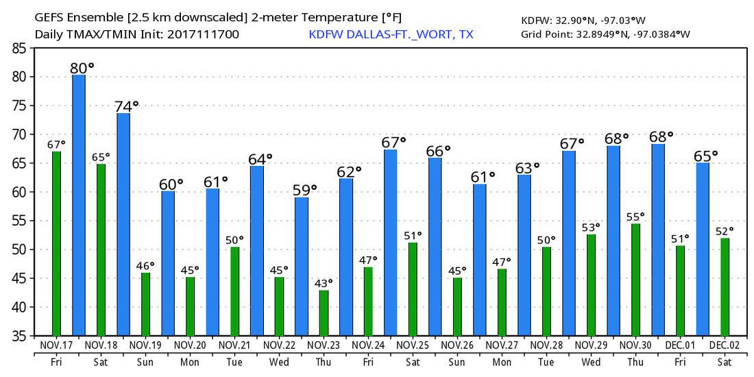 Tropics - A disturbance located in the far southwest Caribbean has a low chance of developing during the next five days. The rest of the Atlantic basin remains quiet.
Mostly Dry Through This Week - We will continue to have another cloudy day across the region behind a surface front, but will most likely stay in dry fashion for most locations. We will mention the chance for a few areas of light drizzle during the day, but rain amounts will stay very light and most communities will stay dry. The high today will be in the upper 60s in most communities. Tomorrow looks to be unseasonably warm with a high in the low 80s with a mix of sun and clouds. The record high in DFW on November 17 is 84 degrees, set in 1986. We stay fairly mild through the end of this week. Football Weather - For the high school playoff games tomorrow night, the weather looks pleasant and dry with temperatures falling from the upper 70s at kickoff, to near the mid 70s by the final whistle. Tomorrow, Summit High School hosts Crowley at Herman Clark Stadium (7:30p kickoff)... the sky will be fair with a kickoff temperature of 79 degrees, falling back to near 74 by the final whistle. The Weekend - A cold front comes through early Saturday morning, which will make for a very pleasant weekend ahead. With abundant sunshine, temperatures should be in the 60-68 degree range for most communities this weekend. Thanksgiving Week - We kick off Thanksgiving week with abundant sunshine and highs in the mid 60s. Tuesday, a few clouds will be added to the mid, but will generally stay comfortable with highs in the low 70s. By Wednesday, another cold front comes through, which will set the stage for a few scattered showers during the day on Wednesday, but rain amounts will stay low. We will remain dry for Thanksgiving Day and Black Friday, with highs generally in the low 60s and cold mornings. See the Texas Weather Discussion Video for more details. 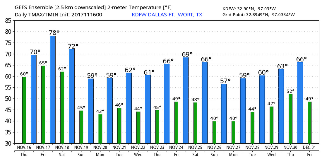 On This Day in 2015 - An "unprecedented" and nocturnal tornado outbreak took place in the lower Great Plains, which spawned 29 tornadoes. Many of them were long-track, significant tornadoes stretching from the panhandle of Texas to Western Kansas. An EF3 tornado spawned near Pampa, Texas, causing significant EF3 damage as it crossed into Roberts county. This day was the part of a multi-day tornado outbreak. Thankfully, no one was killed and only one minor injury was recorded.
Mild Morning - Another warm start to the day in North Texas much like yesterday; temperatures in the upper 60s to low 70s range here. We most likely won't warm much here as we stay in the low 70s for much of the day today. A surface front approaches from the north this afternoon, which should kick off a few rain showers over North Texas today and tomorrow. Not everyone will see rain, and rain amounts will be fairly light for locations that do. Otherwise expect mostly overcast conditions with highs in the upper 60s on both days. Friday - We trend drier and warmer with highs in the mid 80s at the peak of the day. The record high in DFW on November 17 was 84, set in 1986. The general idea is, expect the day to be unseasonably warm with above average temperatures. Football Weather - For the high school playoff games on Friday night, expect more sun than clouds with temperatures falling to the upper 70s by the end of the fourth quarter. Summit High School takes on Crowley for their playoff game at Herman Clark Stadium (kickoff @ 7:30p). For now, expect conditions to be on the warm side with temperatures falling from 81 at kickoff to near 76 by the final whistle. The Weekend - The weekend remains mostly sunny and dry with highs in the mid to upper 60s with lows in the low 40s. Cold nights, but pleasant days ahead. Next Week - We continue to stay pleasant through the early part of next week with highs in the upper 60s and low 70s. By Wednesday, another cold front comes through, which will set off a few scattered showers by Wednesday, most communities stay dry next week. Cold weather is possible on Thanksgiving Day, where many locations are expected to be below average. 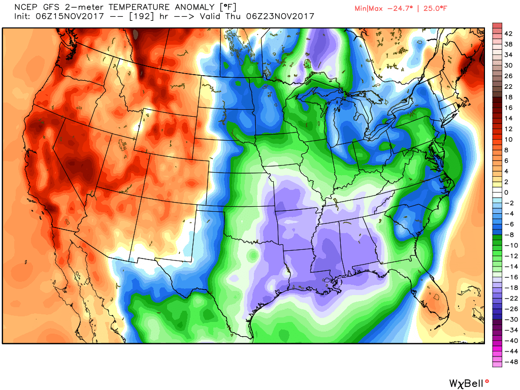 See the Texas Weather Discussion Video for more details.
Tropics - A wave that is located just to the south of the Azores is not expected to develop due to strong upper level winds. The rest of the Atlantic Basin continues to remain quiet. Another Mild Start - Another mild start to the day in North Texas, where temperatures are in the upper 50s to low 60s to start the day. The high should remain in the mid to low 70s for most communities. Clouds will stick around during the morning hours, but should eventually let up a little bit during the afternoon and evening hours. Wednesday and Thursday - A few showers will be possible during the afternoon/evening hours on both days as a surface front pulls some moist air to the state. Wednesday should generally remain overcast with highs in the low 70s, but clouds may eventually let out by Thursday, where the high will be in the mid 70s. Friday and the Weekend - Look for unseasonably warm temperatures on Friday with highs in the low 80s at the peak of the day. We also project a mix of sun and clouds throughout the day as well. After Friday, a cold front comes through during the early morning hours, which should drop temperatures to the mid 60s for highs for Saturday and Sunday. Sunny skies expected for the weekend. Next Week - Expect pleasant weather for most of the Thanksgiving week; cool nights, pleasant days with generally in the mid to upper 60s. By Wednesday, another cold front comes through, which could kick off a few scattered showers before Thanksgiving. The rest of the week looks generally dry. See the Texas Weather Discussion Video for more details. 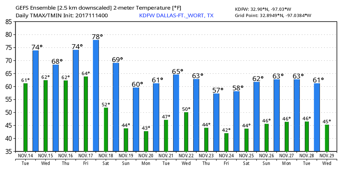 Tropics - A disturbance located over the Eastern Atlantic has a 50/50 chance of developing within the next five days... no threat to the U.S. The rest of the Atlantic Basin remains quiet.
Cool Morning - Another cool morning in North Texas with temperatures generally in the mid 50s. The water vapor satellite shows more clouds emerging from the west, which will make for another cloudy day in North Texas. With the clouds, a few showers will be possible during the afternoon/evening hours, but should be few and far between. We project a high between 68-71 for today. The average high for DFW on November 13 is 67 degrees. More clouds will be possible during the morning hours on Tuesday, but should clear out during the afternoon/evening hours. We start the day with low temperatures in the low 60s, warming to the mid 70s. Midweek - A surface front moves through our area, which will set the stage for a few scattered showers during the afternoon/evening hours on Wednesday and Thursday. Otherwise, expect a mix of sun and clouds with highs ranging from 74 to 77, which is above the average high for both days. Friday and the Weekend - The clouds start to roll out, which will leave a clear sky behind its path. Friday will be a very warm day with highs in the low 80s during the late afternoon hours. We see no issues with any precipitation at this time. Not much change for the weekend. We stay very pleasant and dry for both days, with highs in the upper 60s. No signs of any widespread overcast for any of these days. Next Week - Early next week looks very pleasant with highs in generally in the 60s. A cool down happens during the latter half of the week, which should set the stage for a very pleasant Thanksgiving Day. See the Texas Weather Discussion Video for more details.  Tropics - There is another wave in the open Atlantic that has a 50/50 chance of developing during the next five days, which should stay away from land for now. The rest of the Atlantic Basin is quiet.
Chilly Start -Some places in North Texas are just above freezing conditions this morning. Arlington reports a temperature of 37 degrees as of 5:36 AM. Another round of clouds will make it overcast for the morning hours, eventually letting up as we progress through the day. Temperatures will be at a comfortable 65 degrees, still just below the average high of 68 in DFW for November 10. Football Weather - For the high school football games tonight, the weather should remain pretty comfortable. A clear sky with temperatures falling into the mid 50s by the end of the fourth quarter. Summit High School hosts the Timberview Wolves at Vernon Newsom Stadium for their last football game for the regular season (Summit must win in order to advance to playoffs. kickoff @ 7:30p). the sky will be clear with a kickoff temperature of 53 degrees... falling to near 50 by the final whistle. The Weekend - Saturday morning should be much warmer than now with a projected low in the mid 50s, warming into the mid 60 throughout the day with a mostly overcast sky. As a cold front approaches, we could see a few showers on Sunday, but most communities will continue to stay dry. The high should be in the upper 60s. Next Week - We could see a few stray showers on Monday, but for now, the rest of the week looks very dry and comfortable with highs in the mid 70s and lows in the lower 60s. The GFS continues to suggest that our next chance of thunderstorms is on Friday, November 17... See the Texas Weather Discussion Video for more details. 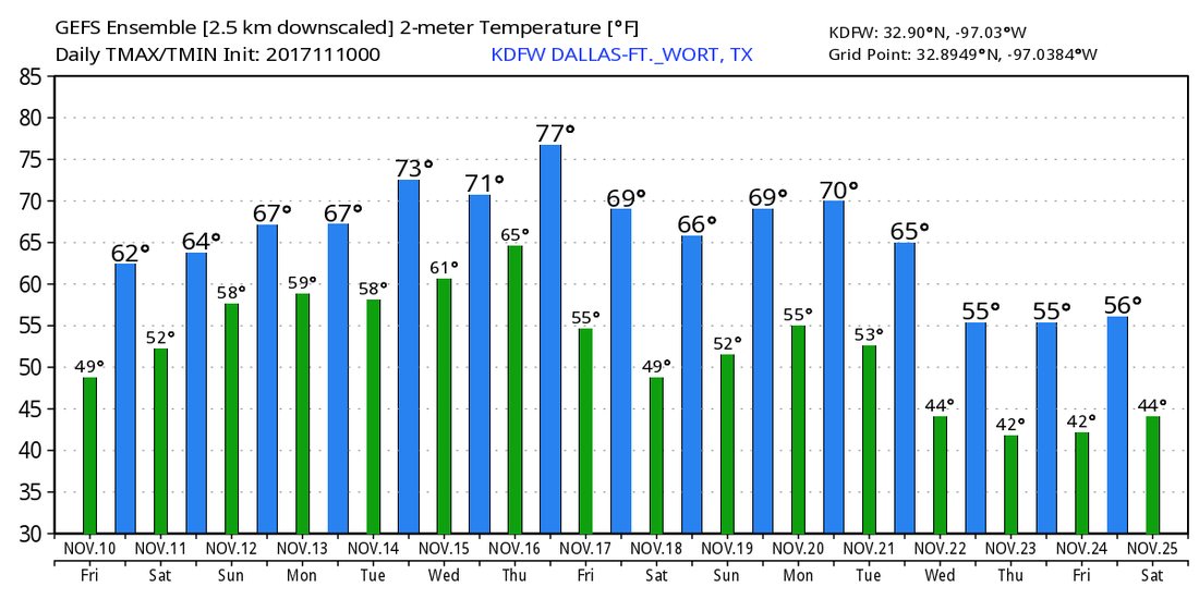 Tropics - Tropical Storm Rina is no more, and the Atlantic Basin remains quiet for the next five days.
Cold Start - After going through much of the day with widespread rain overspreading the region, we are now in a drier cool, dry airmass with temperatures in the mid to upper 40s in the DFW metro area. You won't have to travel air to see temperatures at or below freezing levels. Expect a chilly start to the day with highs in mid 40s, warming to the upper 50s by the peak of the day today with a mix of sun and clouds. Same conditions mirrored on Friday; a mix of sun and clouds with highs in the mid 60s and low in the upper 40s. The Weekend - Saturday will be a mostly overcast Veterans day with clouds increasing throughout the day. Highs still remain in the mid 60s. A few showers will be possible ahead of an approaching front. Nothing too heavy or widespread though. Football Weather - For tomorrow night's high school football games, the weather will be generally comfortable; A clear sky with temperatures falling into the low 60s during the game. Summit High School hosts the Timberview Wolves at Vernon Newsom Stadium for their senior night and last football game of the regular season. For now, the sky will be fair with a kickoff temperature near 59, falling to near 55 by the final whistle. Next Week - Another front could bring a few showers to the state on Monday. Tuesday through Thursday looks pleasant with highs in the 70s... then it looks like we will have a chance at a few thunderstorms by Friday November 17. See the Texas Weather Discussion Video for more details. 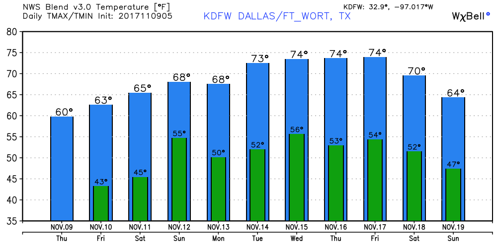 Tropics - Tropical Storm Rina is still in the Northern Atlantic and is expected to become post-tropical cyclone later today. The rest of the Atlantic Basin is quiet. Hurricane season ends on November 9th.
Radar Check - The batch of widespread rain is quickly racing to the east-northeast, making its way towards DFW. 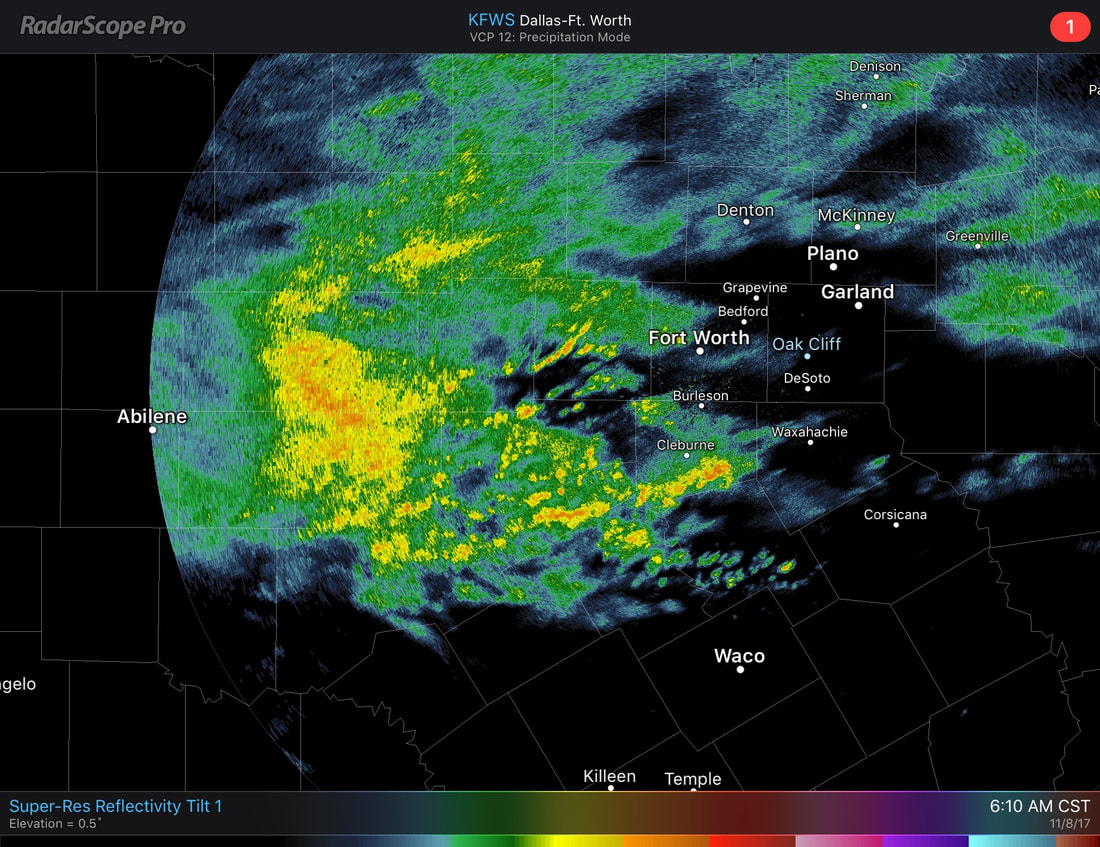 A shortwave trough to the west of Texas will create a upper low which will result in widespread rain for much of the day today. No severe weather is expected, but rain totals up to 1/2-1 inch is possible in North Texas, with higher amounts to the south. As you leave the house, be sure to plan for it to rain all day, starting from 7AM to 7PM. It won't be a downpour, but most communities will see rain off and on throughout the day. The high will remain in the mid 40s throughout the day. Tomorrow and Friday - Early morning clouds will result in a mostly sunny afternoon. The high will be in the upper 50s. The average high for November 9th in DFW is 68. Veterans Day will feature a mix of sun and clouds with highs in the mid 60s after starting the day in the low 50s. The Weekend - Saturday will be another mix of sun and clouds with highs in the low 70s with Saturday morning starting with mid 50s. Sunday looks relatively dry, but we will mention a chance of a shower during the afternoon/evening hours as another front approaches. Moisture and coverage will be very limited, and rain amounts will be very light. The high for Sunday will be in the low 70s. Football Weather - For the high school football games Friday night, it should be pleasant and very comfortable. A clear, dark sky with temperatures falling into the low 60s. Summit High School takes on the Timberwolves for their last game of the regular season and senior night (kickoff @ 7:30p)... the sky will be mostly fair with the temperature dropping from 64 degrees at kickoff to 62-60 by the final whistle. Next Week - We get rid of the rain, and next week looks very pleasant with highs mostly in the 70 degree range; no signs of any widespread rain or severe weather. See the Texas Weather Discussion Video for more details. 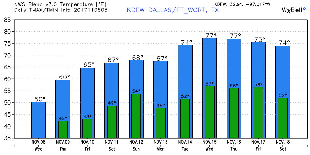 Tropics - Tropical Storm Rina is still out in the central Atlantic, and will stay their for its lifecycle, posing no threat to land. The rest of the Atlantic Basin is quiet.
Below Average - Today will be a much fall-like November day with way more clouds than sun. The high will be in the upper 50s/low 60s in most spots. The average high for November 7 in DFW is 69. A storm or two is still not out of the question, but most communities will remain dry today. Large Contrast - Large contrast in temperatures across the nation this morning... Harve, Montana is down to -8F at 3AM MST. Houston, Texas vicinity reports 75 degrees at the same time. 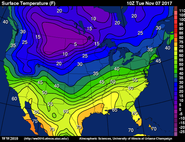 Cold, Wet Wednesday - Showers and storms become likely tomorrow as wave of low pressure enters the area. Looks like we will have a chance of rain all throughout the day, but the brink of it should come during the afternoon and evening hours. Be sure to dress and prepare for it to rain all day on Wednesday, as scattered, random showers and storms will be possible before the main event comes. Rain amounts should generally stay in the one inch range, with higher amounts to the south of North Texas. Otherwise, expect a cold, muggy day with highs only reaching the mid 40s and some lows reaching to the upper 30s. Thursday and Friday - Rain ends early Thursday morning; the sky become partly to mostly sunny with a high just below or at 60 degrees. Friday is another comfortable day with increasing sun, beginning the day in the low 50s, warming to the mid 60s for highs. The Weekend - The day on Saturday should be nice and dry with highs in the low 70s. Clouds will overspread the region on Sunday, but for now, highs still remain in the upper 60s. Next Week - Cool weather continues for North Texas for the next week. No signs of any severe weather issues across the south for the next ten days... See the Texas Weather Discussion Video for more details. 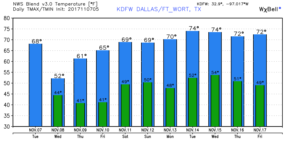 Tropics - Tropical Storm Rina is still in the Central Atlantic and poses no threat to land... It should stay in the open Atlantic. The rest of the basin is quiet.
Another Relatively Mild Start - Although it does say "comfortable" in the title, we still start the day with highs mostly in the low 60s in DFW. As I write this, the surface front is literally on top of North Texas. I will let you pick out where it is. 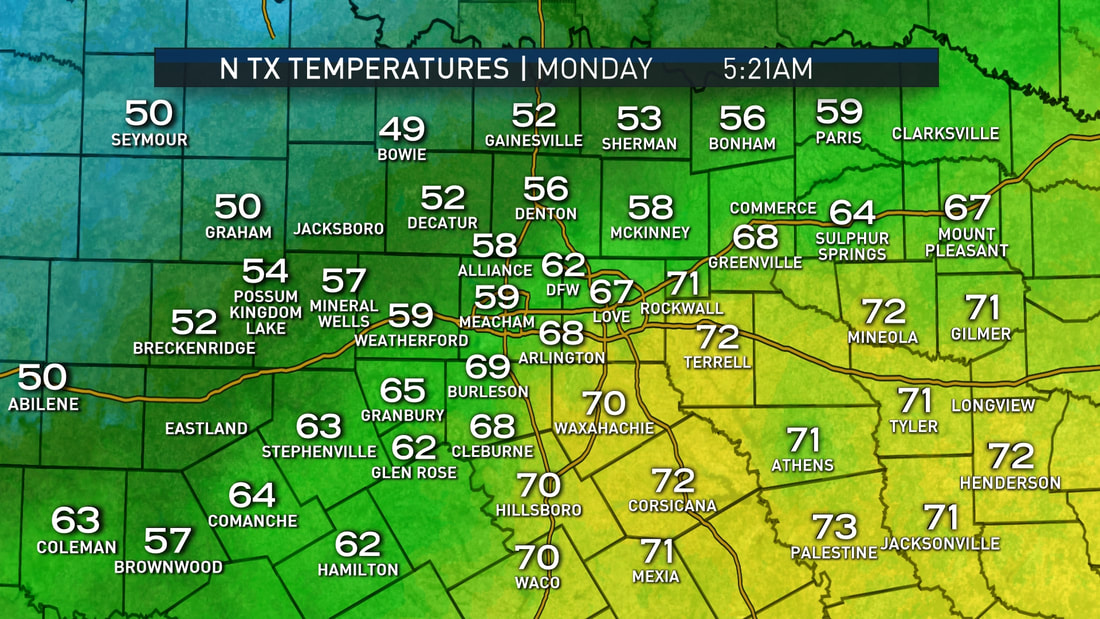 As a result of the cold front, highs will only reach the mid to upper 70s in most spots with clouds out at times. Tuesday - We start to trend cooler with lows potentially in the 40s and highs in the mid 60s. It will still be cloudy at times, but nothing out there to suggest a widespread overcast. Wednesday Through Friday - A disturbance makes its way through the area on Wednesday, which means rain becomes likely during the day. Scattered to numerous showers and storms appear likely during the day on Wednesday, which will bring temperatures down to the upper 40s/low 50s for highs. Lows might even reach the 30s in some spots. Rain amounts should stay within 1 to 1 1/2 inches in North Texas. After Wednesday, we clear out in a dry airmass, which means that the rest of the work week looks quiet and dry with highs in the low to mid 60s, which will be perfect for high school football games on Friday. The Weekend - Not much change. A few scattered showers will be possible on Sunday ahead of another cold front, but a widespread rain is not expected at this time. We continue forecast a dry weekend with highs in the low 70s. Next Week - Another fall like start to the week is expected with highs only in the 60s from now on. Seems like we get rid of 80 degree weather for a long time. See the Texas Weather Discussion Video for more details. 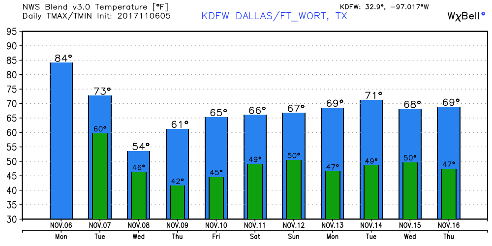 Tropics - A wave (that reminds us that hurricane season runs all the way through November 31) named Tropical Depression Nineteen is in the Central Atlantic, and is expected to become Tropical Storm Rina within the next 12 hours. If anything forms, it should just move out to the Northern Atlantic, posing no threat to land. The rest of the Atlantic Basin remains quiet. 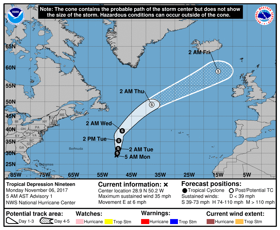 Quiet Start - Another fairly mild start to the day in North-Central Texas; DFW holds 64 degrees this morning and Arlington holds 60. Despite the warm morning temperatures, highs should only reach the mid 70s today as a result of a stalled surface front in north Texas with abundant sunshine; perfect for the high school football games today. Football Weather - For today's high school football games, most games will be played under a sunny sky with temperatures falling from the upper 60s by kickoff to the low 60s/upper 50s by the final whistle today. Summit High School takes on their rival, Legacy High School, at Vernon Newsom Stadium this evening (kickoff @ 7:30p). For now, it looks like the game will be played under a clear sky with temperatures falling from 67 at kickoff to near 60 by the end of the first quarter. Most stadiums will remain dry. The Weekend - The surface front lifts out of North Texas by Saturday, and we trend warmer with highs mostly in the mid to upper 80s with abundant sunshine. The projected high for DFW on Sunday is 88 degrees. The record high for DFW on November 5 is 88 degrees, set in 2005. If we can get any warmer than that, we may be at another record temperature day in DFW. Next Week - After Monday, we go back to fall like temperatures as a result of the next cold front coming through. The GFS has backed off the idea of showers and storms on Tuesday, but we will need a bit more consistency to completely take it out of the forecast. But for now, we generally stay mostly dry with highs in the 60-80 degree range. See the Texas Weather Discussion Video for more details. 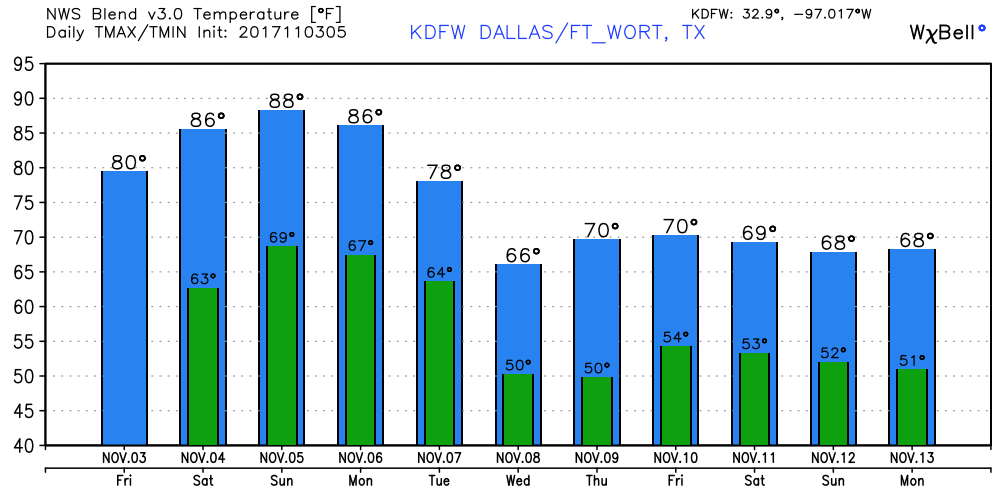 Tropics - The Atlantic Basin remains quiet, and no new tropical storms is expected for the next five days.
Mild Start - With the upper ridge in our area and a dry airmass, we start out the day pretty mild with highs in the mid 60s for the DFW area. Currently, our high temperature today is forecast to be 92. If the forecast is right, that would be first time a temperature 90 or above has been recorded in the month of November. The current record was set in November 2, 2012 with a high of 87 degrees. Expect today to feel more like a summer day. Additionally, due to elevated temperatures and southwest winds at 10-15 mph (gusting to 25mph), elevated to critical fire weather will be possible behind the dryline. Be sure to check if your county is under a burn ban for today. Tomorrow - We trend ever so slightly cooler with highs sticking around in the mid 80s. Winds will calm to 5 to 10 mph, which will reduce any fire danger issues for Friday. Football Weather - For tomorrow night's high school football games, most of the games will be played under a clear sky with temperatures falling from the mid 80s at kickoff to near the upper 70s by the final whistle. Summit High School takes on Legacy High School at Newsom Stadium tomorrow night (kickoff @ 7:30p). For now, the game will be played under a clear sky as the sun fades away, with the temperature falling from 85 at kickoff to 82 by the end of the fourth quarter. The Weekend - Not much change. We continue to stay dry, free of any widespread clouds. Highs still stick around in the mid 80s. Next Week - We stay the same for the early part of next week, then a cold front comes through by Tuesday evening which will drop highs to the upper 60s - fall-like weather returns. See the Texas Weather Discussion Video for more details. 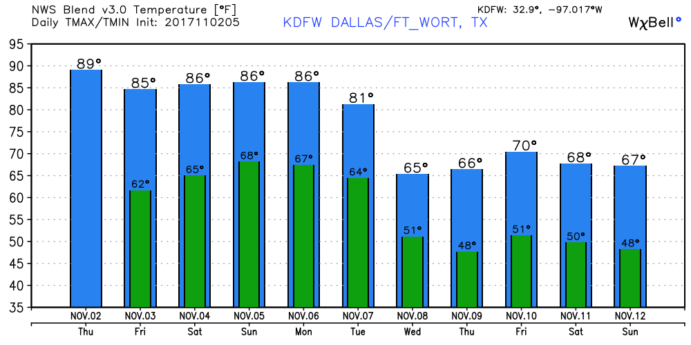 Tropics - The Atlantic Basin is quiet, and no new tropical storms is expected for the next five days.
|
Archives
April 2024
Categories |
 RSS Feed