
|
So far, and it is just Monday, we are already doing better than last week in terms of temperatures; only 73 degrees in Arlington but if you go a little to the east, we can see Sulphur Springs in the 60s. At about the same time last week, most locations on that map were already in the 80s. We are expecting temperatures to only reach the mid 90s in most spots, we should have plenty of sunshine with showers and storms well off to the west. Better chances will come later in the week or even tomorrow where some spots may get wet. In fact, the chance of any one spot getting wet Tuesday through Friday will range from 20-50, with the highest chances on Wednesday. So it seems like everyday this work week (except Monday of course) we will have at least some chance of seeing some rain. Not all locations will see storms and this week will not be a washout. But, at least temperatures will stay in the upper 80s to low 90s for much of this week with lower humidity values. Otherwise expect partly to mostly cloudy skies for much of this week. The Weekend - Rain chances taper off by the weekend and we should stay dry with plenty of sunshine. It should feel great since we are not as humid. As a result, the temperatures should continue to stay in the low 90s which should make things feel pleasant. Next Week - Next week should feel a little more similar to this week. Lots of sunshine with chances for showers and storms Monday and Wednesday. Plus, factor in the lower humidity values, and it should feel pleasant with highs in the low to mid 90s with clouds out at times. I'd say we are very fortunate to not have to deal with excessively hot weather during the hottest part of summer. See the Texas Weather Outlook for more details. 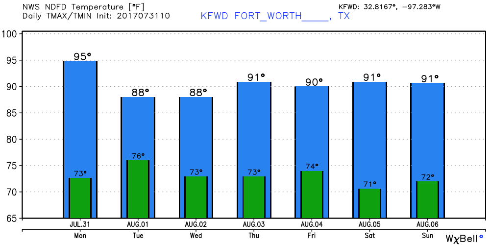 Have a great day. I may be back later with an update on the tropics.
Donovan Neal AHhh. We are already starting the day out mild with highs in the middle 80s in most spots. Dallas Love Field actually had a temperature of 87 degrees at 4:51 AM. When you start to see temps that hot in the early morning hours, you already know that it will be pretty hot later in the afternoon and evening. In fact, today will most likely be the hottest day of the year thus far with highs approaching 102. The heat index values will make it feel even hotter. But fear not, today will also most likely be the last day of excessively hot weather for a while as a cooling trend starts to take over during the weekend and next week, bringing multiple chances of showers and storms and clouds. A Heat Advisory still remains in effect until this evening due to heat index values approaching 103-110. The Weekend - We will start to see the temperature come down significantly with the ridge weakening and a surface front dropping from the north. This will also bring a chance for scattered showers and storms for mainly Saturday. Again, not everyone will see rain. The chances of one spot getting wet tomorrow or Sunday is in the 20-30 percent category. Your rain amounts will vary. Otherwise, expect partly to mostly cloudy conditions for most of the day with highs only in the mid to upper 90s. Next Week - The cooling trend continues with most temperatures only making it into the low 90s next week. One model had a max temperature of 89 for one day, but I believe that is simply too good to be true. Isolated to scattered showers will be possible during the middle of the work week with higher coverage to the north and west of DFW. For now, the best chance of any one spot getting wet is currently in the 20-30 percent bracket, but that could change as time goes on. The high will only get to 92-94 in most locations next week, and that is not bad at all for the hottest part of summer. See the Texas Weather Outlook video for more details. 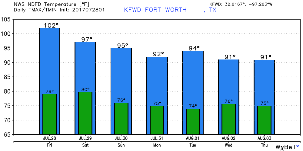 Tropical Talk - There is one measly little tropical wave still in the Atlantic Basin. Some slow development is possible with this system, but there is a lot of dry air in the Atlantic, so it is not likely. The NHC only gives it a 20% chance of development during the next five days.  Have a great weekend! I will be back with the updates on Monday.
Donovan Neal It is already 80 degrees in some spots in North Texas today. In fact, at 5:02 this morning, DFW had a temperature reading of 82. When we start out the day in the 80s, you know it is going to be pretty hot this late afternoon and evening. In fact, a Heat Advisory still remains in effect today through Thursday evening, where heat indices of 105-109 will be possible due to increase dewpoint values. The weather will be consistent for the rest of this week; mostly sunny and hot with highs at or near 100 degrees. Rain chances should stay at a minimum due to the upper level ridge creating a hotter and drier atmosphere. The Weekend - We are in luck! Not only will we see a chance of showers and storms, but we will also see temperatures back off a little more! This is because the upper level high will shift back to the west and will create an environment for moisture to come back. Storms will be possible along a cold front this weekend. We can't be too specific yet, but the chance of any one spot getting wet is in the 20-30 percent bracket. Otherwise, expect mostly cloudy skies with highs in the mid 90s; yes, that is much better than what we are in right now. The Week - It will be even cooler next week! Expect highs in the mid to lower 90s for most of the week in addition to increased rain chances, especially during the latter half of the week. It looks like another cold front will be possible late next week, but too early out to tell. But good news is, no signs of any excessively hot weather, especially during the hottest part of the year. See the Texas Weather Outlook for more details. 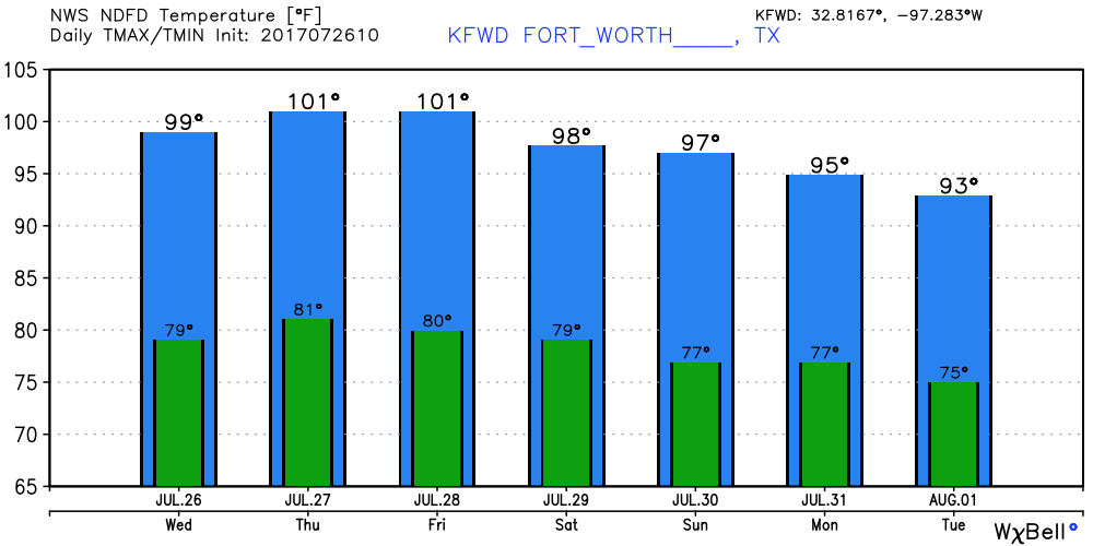 Tropical Talk - There is one weak little wave in the African Coast. Due to the amount of dry air in the Atlantic Basin, I don't think we should worry about it short-term, and in the medium range. 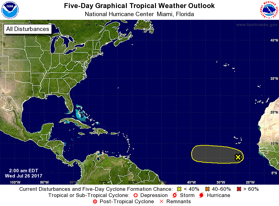 Make it a great day!
Donovan Neal It is a classic summer-time evening right now. Temperatures are near the 100s in most spots with heat index values approaching 107 or further. It won't take long to find a location that is hotter than us in the Central Plains, where St. Louis has heat index readings of 115. Ouch. Adjacent locations are no doubt just as hot. The Heat Advisory for us still remains in effect until 8 PM tomorrow, but regardless of where you are, you are still dealing with summer-like heat. Weekend - Although Saturday looks pretty typical, by Sunday, the ridge starts to weaken a little, and you introduce a chance for isolated showers and storms, which will very slightly lower heat levels. The chance of one spot getting wet is in the 20-40 percent bracket, so not everyone will see rain and this will not be a washout. Otherwise, expect highs in the upper 90s still, with the best storm chances during the afternoon/evening hours. Next Week - The risk for a few showers and storms continues Monday, before dissipating later in the week. Highs will mostly be at or near the 100 degree mark on most days of the week. See the Texas Weather Outlook video for more details. 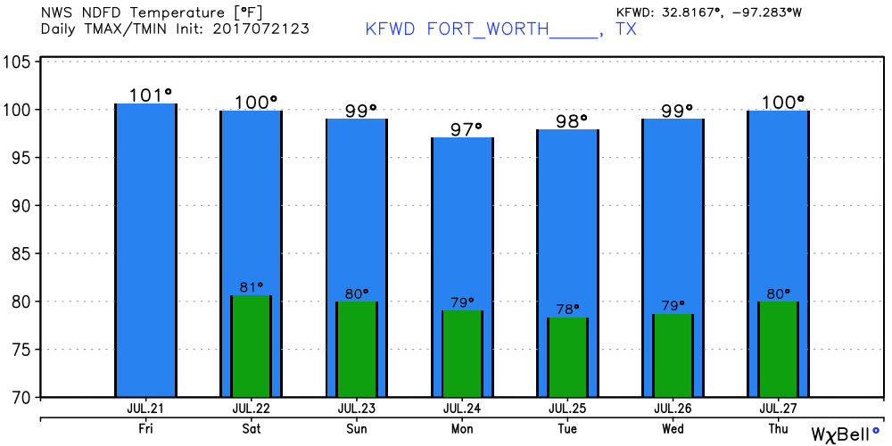 Tropics? - It is very peaceful in the Atlantic Basin, and will continue that pattern for the next five days.
The next blog post will be 6 AM Monday morning, due to summer band starting as well as the start of school following that. This will be my school schedule. Have a great weekend. Donovan Neal The Heat of the Year - DFW hit 97 degrees yesterday. If a location in the DFW hits 100 degrees, it will most likely be the warmest day of the year. Going a little towards the north, a weather station in Plano reported 100 degrees with a heat index of 104. Heat Advisory - Heat Advisory is in effect for much of the coverage area until 8 PM Saturday due to heat index values of 103-107. There is an upper high that is mainly in the middle of the plains, that expanded to cover much of Texas which will keep highs close to 100s with no precipitation. Some clouds are possible, but will not really make a big difference. Not really changing tomorrow; we will continue to see highs at or just below 100 degrees with no precipitation with some clouds. The Weekend - By Sunday, the upper ridge should weaken slightly here, and we might see more cloud coverage and maybe even some showers and storms, if model runs show consistency. Nonetheless, expect highs to continue to be at or above 100 degrees in most locations. If anything, the chance of any one spot getting wet is in the 10% category, but we will continue to see with other model runs. Next Seven Days - Some of the hottest weather in the U.S. will be to the north of here, but I still project temperatures of 95-98 for most days of this week. Monday seems to be the only day with an isolated storm or two next week. But regardless, expect a hot week with little to no rainfall. See the Texas Weather Outlook for more details. 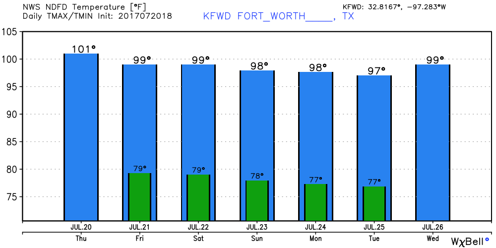 Tropical Talk - A lot of dry air from Africa is covering most of the Atlantic Basin. As a result, the Atlantic is quiet today and will continue to be for the next five days.
Have a great rest of the day, and stay cool! Donovan Neal As expected, things are mostly sunny and hot with temperatures nearing the 100-degree mark in most locations. In fact, Graham has already reached 100-degrees by 5:00 today. If go farther to north near Topeka, Kansas, which is in the core of the ridge, have temperatures of near 100-degrees with heat index values of 100-115! Tomorrow and Friday - No reason to derail from the standard late July forecast. Mostly sunny, with highs nearing 100-degrees. Just know that you have the chance of reaching 100 degrees every day, but you won't see 3 to 7 consistent days. If you go along I-35 north, the farther north you go, the closer to the center of the heat bubble you are going. Weekend - Not much change here. By Sunday, the ridge moves to the west by a tad, which will open the door for more chances of showers and thunderstorms to the east (Past Shreveport). Here, you might see a little bit more cloud coverage but that won't change anything as temperatures are continuing to approach near 100 degrees. Next Week - Not much change so far. Mostly sunny with highs still holding between 96-102 degrees. Which is on average for late July. We are quickly approaching the peak of summer, if climatology is correct. See the Texas Weather Outlook for more details. 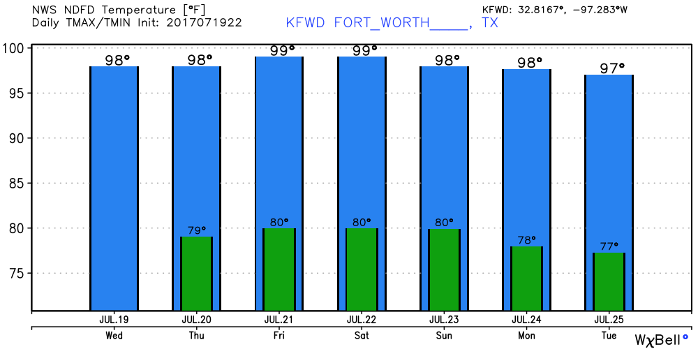 Where is Don - Don dissipated into an open wave as of yesterday afternoon and is not expected to develop due to drier air. Another weak wave is in the middle Atlantic near the coast of Africa, but is not expected to continue further due to drier air. Ultimately, nothing to worry about for the next five days.
Have a great rest of the day. Donovan Neal. Today may be the last real hope of seeing an isolated storm or two in North Texas before we go completely dry for a while. Temperatures at mid-day today range from 88-95 degrees. There will be a very slight chance of a pop-up shower or two, but those chances will become non-existent as the week goes on and the ridge strengthens. Warm air aloft + a strong ridge = convection struggles to initiate. With less showers and clouds, heat levels start to rize. The high today will mostly peak at 98 with some spots reaching the triple digits; it is still a possibility. After tomorrow, highs in the 100-degree range will be the talk for much of the remaining week and also much of next week. Additionally, we can expect heat index values to range from 105 to even 110 degrees. Not very surprising given the time of the year, but we are a few degrees above average. Weekend - Not much change in the forecast. It will continue to be mostly sunny and very hot with highs in the 100s. No rain expected this weekend. Next Week - Early next week, clouds may return to the area, but temperatures are still expected to be just at or a little above 100-degrees. By the latter half of the week, heights start to come down, and the ridge pushes to the west, which may allow some moisture to return to the area. Showers and storms will be possible along a surface front coming from the north. Regardless, it will still be very hot for the rest of this week and next week. See the Texas Weather Outlook Video for more details. 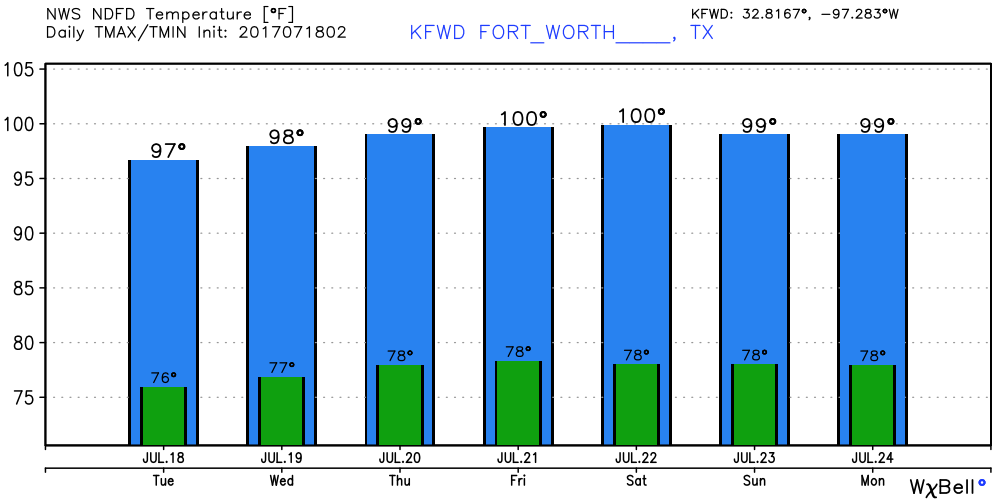 Tropical Talk - Tropical Storm Don formed just to the south of Barbados yesterday afternoon. This storm is expected to pass through the Winward Islands tonight and the southern Caribbean Sea tomorrow. Peak winds were about 50 MPH, but not expected to reach hurricane strength. The NHC shows Don weakening into a depression by tomorrow weakening to an open wave by Thursday as it enters a harsh environment from Southern America. There is another area of concern (Invest 96L) that is riding on Don. This is expected to gain latitude and track to the northwest. Some development of this is possible over the next five days. 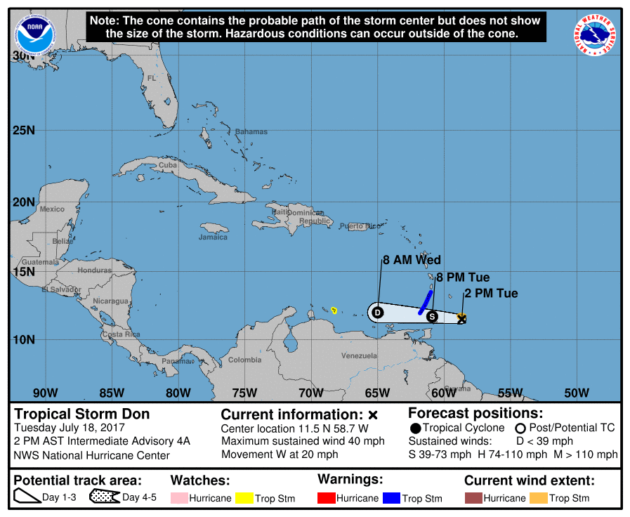 Have a great rest of the day, and stay cool.
Donovan Neal Today, we are not as hot as we will be later in the week, but still pretty hot.  Radar Update - Scattered showers and storms are more likely the farther south past Waco that you go, where the atmosphere is a little more moist and unstable. If anything reaches North Texas, it will most likely be in the form of an isolated shower or two that quickly dissipates. Otherwise, expect mostly sunny skies with highs in the 95-98 range. Rest of the Week - The weather will feel hotter and drier as an upper ridge begins to build in. Tomorrow, if we see anything in terms of precipitation, it will be more spaced, and should dissipate quicker, including anything farther south. Going forward after tomorrow we won't have ANY chances of rain for the next several days. In fact, by Wednesday or Thursday, we will have a good chance of temperatures reaching the century mark (100 degrees). With higher temperatures, comes higher heat index values, which will range from 103-110 during most days of this heat wave, which will be the story for Thursday and out, as the heat 'dome' builds in a large chunk of the US. This Weekend - Not much change in the forecast. Still very sunny with highs likely in the triple digits with no precipitation... Next Week (The start of Summer Band :D) - Models suggest that the ridge starts to weaken, which also means that temperatures will come down a tad, and we will start to see a bit better cloud coverage and slightly better chances of precipitation. Please see the Texas Weather Outlook for more details.  Tropical Talk - Two tropical waves to talk about in the Atlantic. The first one has a "flip a coin" chance of developing, but will remain low in latitude and will not impact the Gulf of Mexico or the US.  Have a great rest of the day.
Donovan Neal Radar Update - Scattered showers and storms have formed over North-Central Texas early this afternoon. If not stationary, slowly moving to the south, producing brief downpours and occasional lightning. 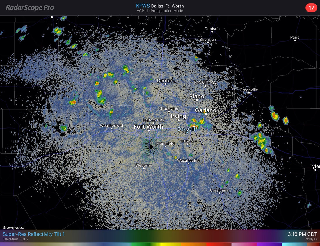 Any storms that are left should dissipate during the evening hours. Aside from the storms, most locations are already in the mid to upper 90s in the afternoon with a mix of sun and clouds. Weekend - There will be a risk for scattered showers and thunderstorms during the afternoon/evening hours each day of the weekend as a cold front drops into our area from the north. Due to the scattered nature of these storms, please note that not all locations will see rain. In fact, most won't see anything at all during the weekend. I'd say the chances of one spot getting wet is in the 30-35 percent category. By no means this will be a weekend washout. Other than, we will stick with the typical mid-July forecast; Mostly sunny and hot with highs in the mid to upper 90s. Next Week - As the upper ridge in the south builds, heights will start to come up around North Texas, which means that things will be drier and feel a little hotter as we get close to the peak of the summer in North Texas. Leftover moisture should still linger around Monday and Tuesday, so we mention still hold a chance for isolated showers and storms.The chance of any one spot getting wet will be in the 20% category. With drier and warmer air aloft, the chances will not be as great as in the weekend. Past that, temperatures should stay in the mid to upper 90s, average temperatures for mid July. See the Texas Weather Outlook for more details. 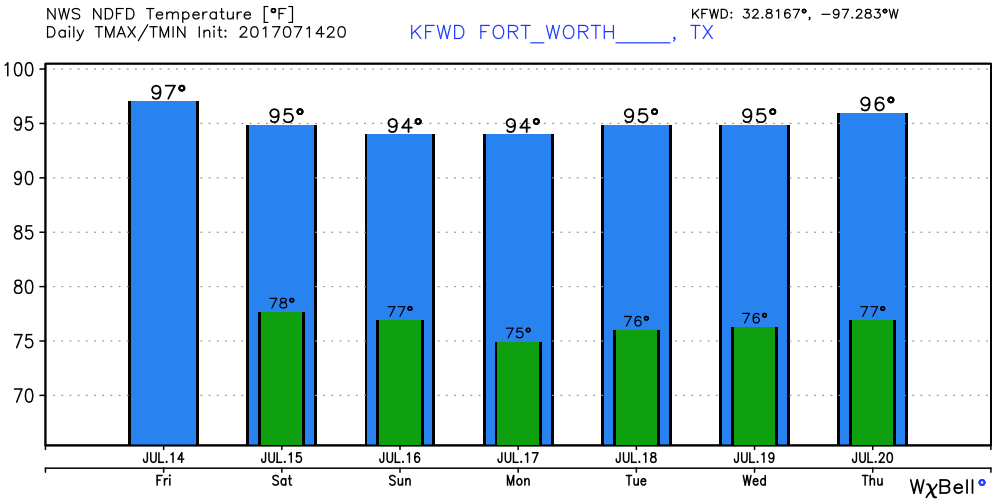 Tropical Talk - If you're heading out in the Atlantic, you're in luck! No activity in the form of tropical cyclones is expected for the next week. Remember, the peak of hurricane season is usually in August and September.  Have a great rest of the day!
Donovan Neal Sunshine, sunshine, and more sunshine (some clouds) - We are in the midst of summer, the time where forecasts don't change that much; if you don't have isolated showers, you have hot and humid conditions with highs in the mid to upper 90s. And if you get rain, it will probably not last as long as you think. We will see this this summer-like weather today through Friday. Weekend - As I have mentioned before, the risk for scattered showers and storms will increase throughout the weekend. With a surface front coming towards us from the north, and the upper level high moves back to the west, that will create a north flow aloft that will allow multiple rounds of showers and thunderstorms to move through here throughout the weekend. The chance of one spot getting wet will be in the 20-30 percent category throughout the weekend and Monday. Otherwise, expect mostly sunny conditions with clouds out at times, highs in the mid to upper 90s. Next Week - Not much change will occur. After Monday, we should continue to stay in summer-like conditions; mostly sunny, with highs in the mid to upper 90s. Keep in mind that the peak of summer-like weather is usually in late July/August. Please see the Texas Weather Outlook video for more details.  Tropical Talk - The Atlantic should stay dry for the next five days with no tropical cyclone activity expected. 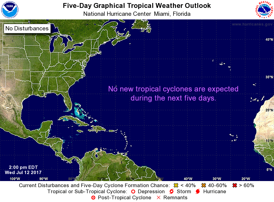 Thank you and have a great rest of the day.
Donovan Neal Current Conditions - Very beautiful day today without nearly a cloud in the sky! Temperatures are already in the low 90s at mid-day, warmer than what we saw at just about the same time yesterday where most locations were in the upper 80s to low 90s. No precipitation anywhere in North Texas right now. For the Rest of this Week - Very standard July forecast for the next three days. Sunny skies, hot and humid with highs in the mid to upper 90s in most spots with some clouds out at times. No reason to not stick with a typical July forecast. Friday and the Weekend - This is where things might get a little interesting here. A surface front will approach from the northeast on Saturday, and the ridge will pull back to the west, which will create a north flow aloft that will bring multiple chances of showers and thunderstorms over the weekend. The chance of one spot getting wet in North Texas over the weekend is 20%, but that could very well get changed with time. So bottom line, everyone will have at least a chance of some isolated to scattered showers and thunderstorms multiple times. Otherwise, expect partly to mostly cloudy skies with highs in the mid to upper 90s. Early Next Week - Monday and out, we will stick with sunny skies with highs in the mid to upper 90s. The chance of rain for these days are so small that they are not worth mentioning. Other than that, still average weather for July. Please see the Texas Weather Outlook for more details. 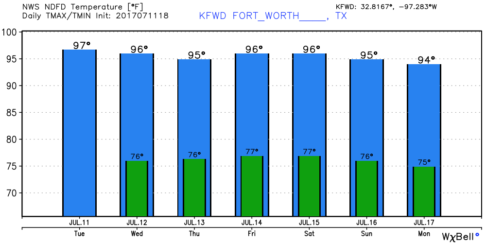 Tropical Talk - For the past few days, there were two areas of concern over the Atlantic; A tropical wave just off of the Cabo Verde Islands and the remnants of Tropical Depression Four. Since they are both in an atmosphere with dry air and low shear, we won't have to worry about any formation from any of them for the next five days. Even the latest GFS model run shows nothing over the coast of Florida and the adjacent coastal areas. 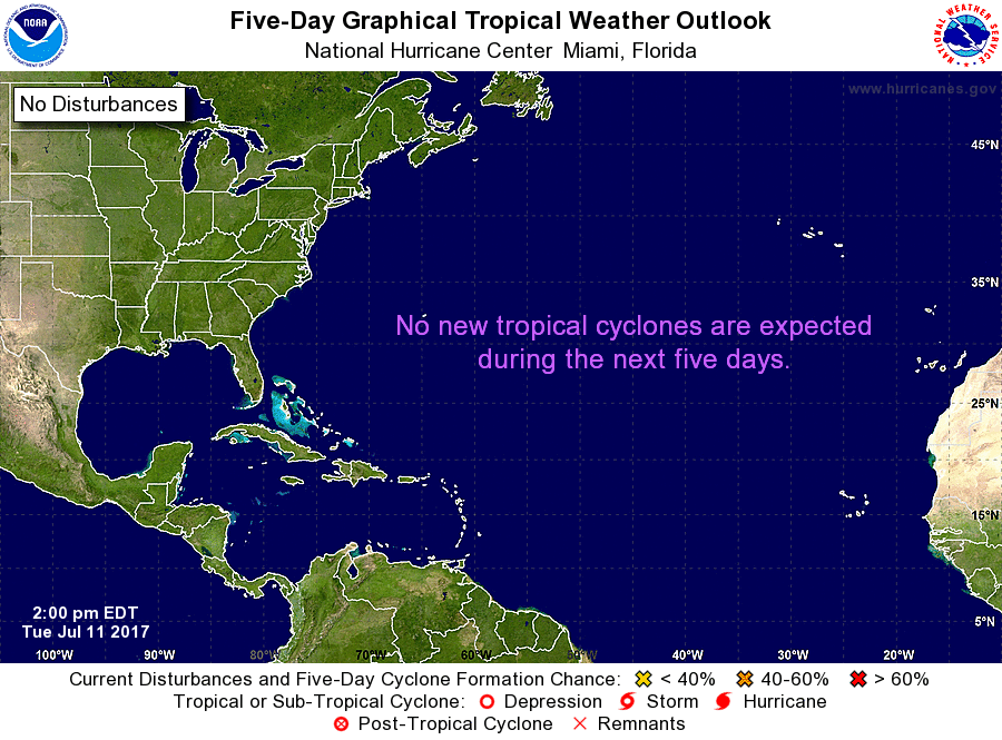 Thank you and have a great rest of the day.
Donovan Neal Great day out today! However it is hot right now with temperatures in the upper 80s to lower 90s. Don't be fooled by this. There are many weather stations across the metroplex that detect heat indexes of 100 degrees. If you are out and about, make sure that you drink plenty of water and you are not spending too much time outside. It will continue to stay dry in most spots in the metroplex. There will be a chance an isolated storm or two in the area by late afternoon/evening. Higher rain chances will be to the south of Corsicana. Otherwise, expect highs to reach the mid 90s in most locations, which is just about on average for July. For the Rest of the Week - Tuesday through Thursday should stay precipitation-free with highs in the mid to upper 90s with a few clouds. For locations to the east of I-35, any one spot of seeing an isolated shower or storm is 20%. Weekend - After Friday, the chance for showers and thunderstorms start to increase as a surface front makes its way from the north. These are the days where just about anyone in North Texas has a chance of showers and thunderstorms. Despite the cold front coming through the area and the cloud coverage, we still expect things to be hot with highs peeking mainly at 97. We will continue to have rain chances until Wednesday of next week. Early Next Week - Most of the early week should continue with summer-time weather - highs in the mid to upper 90s, with some clouds out at times. Monday through Wednesday, you might mention the chance of an isolated storm or two. Please see the Texas Weather Outlook for more details. 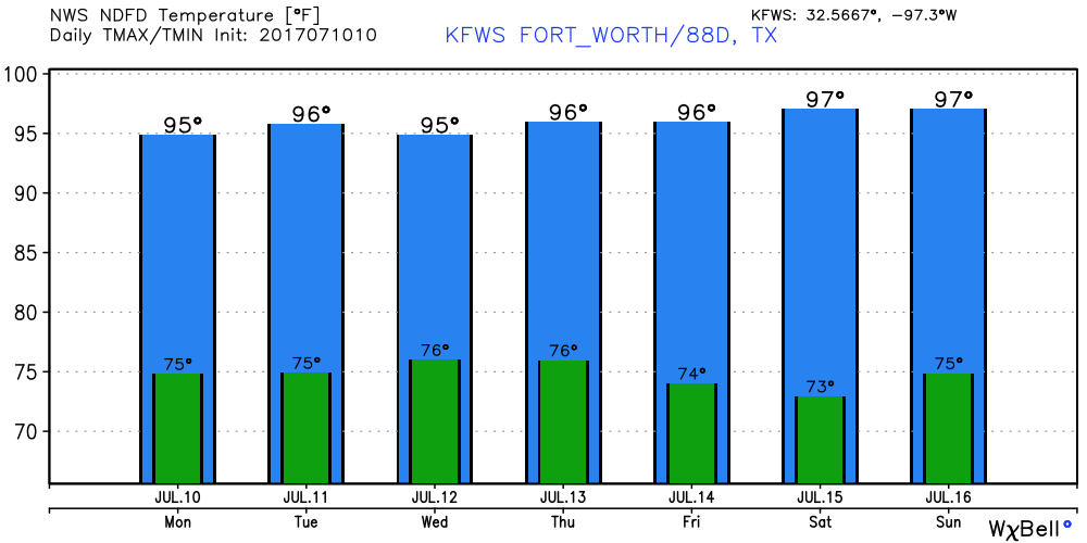 Tropical Talk - There is a weak tropical wave located in Eastern Atlantic that could show some signs of development in the next five days. The National Hurricane Center only gives a 20% chance of cyclone development over the course of five days. However, the GFS (that is known for being totally inaccurate past ten days) shows a significant tropical low hugging and affecting the coast of Florida next week, but the European (which is far more reliable) shows nothing over this time period. 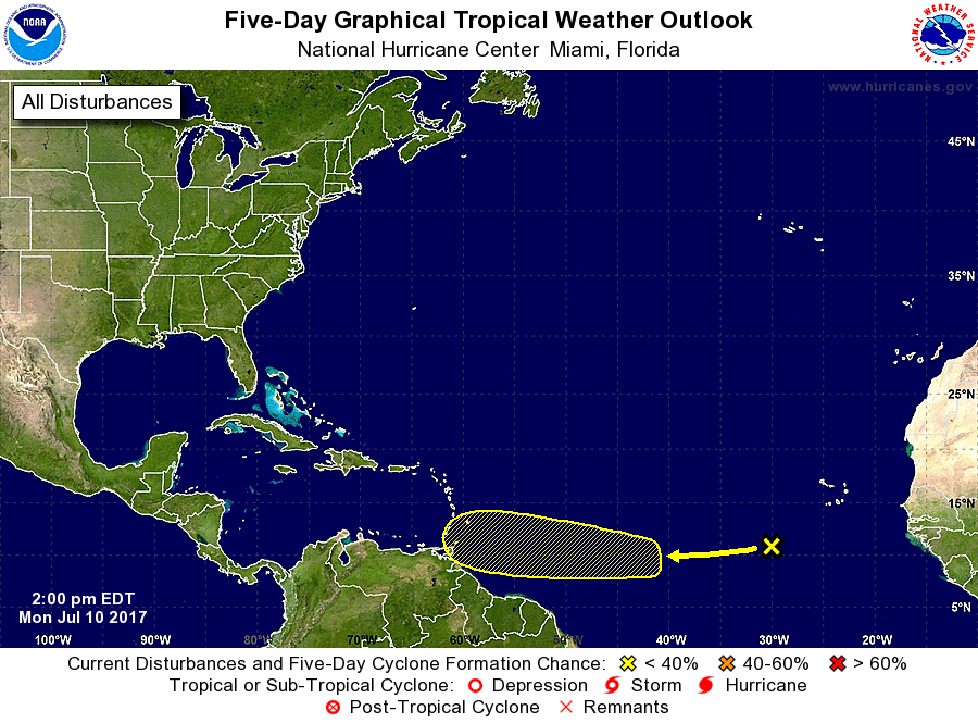 Have a great rest of the day.
God Bless... Donovan Neal |
Archives
April 2024
Categories |
 RSS Feed