
|
AHhh. We are already starting the day out mild with highs in the middle 80s in most spots. Dallas Love Field actually had a temperature of 87 degrees at 4:51 AM. When you start to see temps that hot in the early morning hours, you already know that it will be pretty hot later in the afternoon and evening. In fact, today will most likely be the hottest day of the year thus far with highs approaching 102. The heat index values will make it feel even hotter. But fear not, today will also most likely be the last day of excessively hot weather for a while as a cooling trend starts to take over during the weekend and next week, bringing multiple chances of showers and storms and clouds. A Heat Advisory still remains in effect until this evening due to heat index values approaching 103-110. The Weekend - We will start to see the temperature come down significantly with the ridge weakening and a surface front dropping from the north. This will also bring a chance for scattered showers and storms for mainly Saturday. Again, not everyone will see rain. The chances of one spot getting wet tomorrow or Sunday is in the 20-30 percent category. Your rain amounts will vary. Otherwise, expect partly to mostly cloudy conditions for most of the day with highs only in the mid to upper 90s. Next Week - The cooling trend continues with most temperatures only making it into the low 90s next week. One model had a max temperature of 89 for one day, but I believe that is simply too good to be true. Isolated to scattered showers will be possible during the middle of the work week with higher coverage to the north and west of DFW. For now, the best chance of any one spot getting wet is currently in the 20-30 percent bracket, but that could change as time goes on. The high will only get to 92-94 in most locations next week, and that is not bad at all for the hottest part of summer. See the Texas Weather Outlook video for more details. 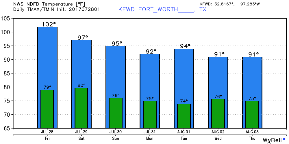 Tropical Talk - There is one measly little tropical wave still in the Atlantic Basin. Some slow development is possible with this system, but there is a lot of dry air in the Atlantic, so it is not likely. The NHC only gives it a 20% chance of development during the next five days. 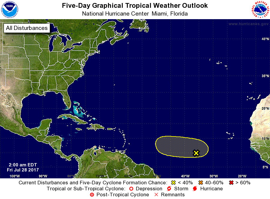 Have a great weekend! I will be back with the updates on Monday.
Donovan Neal |
Archives
March 2023
Categories |
 RSS Feed
