
|
It is a classic summer-time evening right now. Temperatures are near the 100s in most spots with heat index values approaching 107 or further. It won't take long to find a location that is hotter than us in the Central Plains, where St. Louis has heat index readings of 115. Ouch. Adjacent locations are no doubt just as hot. The Heat Advisory for us still remains in effect until 8 PM tomorrow, but regardless of where you are, you are still dealing with summer-like heat. Weekend - Although Saturday looks pretty typical, by Sunday, the ridge starts to weaken a little, and you introduce a chance for isolated showers and storms, which will very slightly lower heat levels. The chance of one spot getting wet is in the 20-40 percent bracket, so not everyone will see rain and this will not be a washout. Otherwise, expect highs in the upper 90s still, with the best storm chances during the afternoon/evening hours. Next Week - The risk for a few showers and storms continues Monday, before dissipating later in the week. Highs will mostly be at or near the 100 degree mark on most days of the week. See the Texas Weather Outlook video for more details. 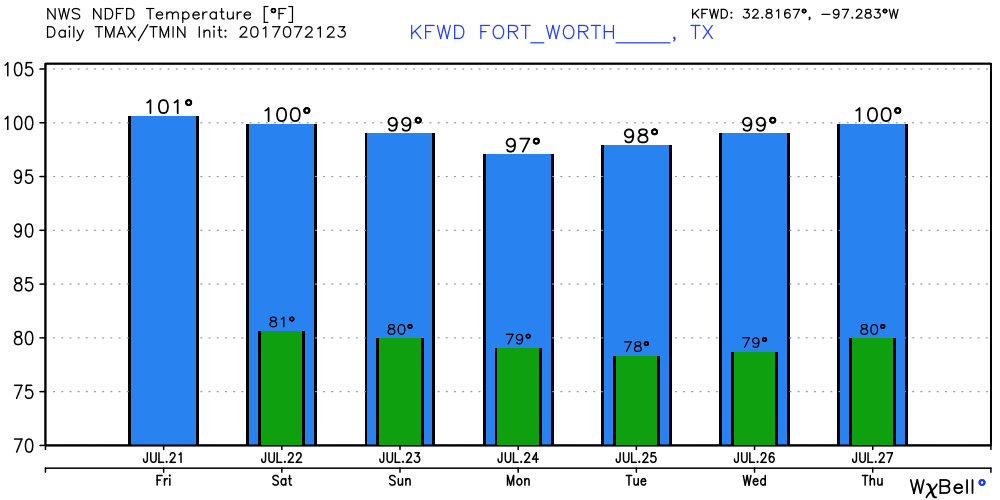 Tropics? - It is very peaceful in the Atlantic Basin, and will continue that pattern for the next five days.
The next blog post will be 6 AM Monday morning, due to summer band starting as well as the start of school following that. This will be my school schedule. Have a great weekend. Donovan Neal |
Archives
March 2023
Categories |
 RSS Feed
