
|
HUMID MORNING: With the absence of wind from yesterday, it is a very muggy late June morning across North Texas with dewpoints in the mid 70s to mid 80s range. We note some showers out in Central Texas, but we might see a random afternoon storm or two as the air continues to heat and become unstable. I expect a high in the mid 90s range across the area this afternoon with heat indices well in the triple digits. The average high for DFW on June 30 is 94°. REST OF THE WEEK: Not much change for the rest of the work week. Partly to mostly sunny skies with highs in the upper 90s. Heat indices will once again be well in the triple digits. As such, a Heat Advisory is in effect for much of the North Texas region until at least Wednesday. Keep in mind that this can be extended for a couple more days if need be. 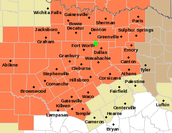 FOURTH OF JULY WEEKEND: High PWAT (precipitable water) values will cover much of North and Central Texas on Saturday, so we will mention mostly cloudy skies with the chance of isolated to scattered afternoon and evening showers and storms. Most of them (not all) will come from around noon to 9:00 PM, and the odds of any one spot getting wet is about one in five right now. There is no way of knowing in advance where and when they form. You just have to watch the radar, especially if you have outdoor festivities planned. Remember, when thunder roars, go indoors. We have had one lightning fatality so far this year, and that is one too many. Highs will be in the mid 90s for the weekend.
NEXT WEEK: We will continue to roll with a persistent forecast of a mostly to partly sunny sky with highs in the mid 90s and very hot heat indices. TROPICS: A trough of low pressure is located off the coast of North Carolina. Significant development of this system is not anticipated while it moves generally northeastward, away from the east coast of the United States and merges with a frontal boundary. The rest of the Atlantic basin is very quiet. ON THIS DAY IN 1912: An estimated F4 tornado ripped through Regina, Saskatchewan, Canada on this day. The storm became the deadliest tornado in Canada’s history as it killed 28 people along a rare, 18.5-mile track from south to north. Look for the next weather discussion and blog update at around noon tomorrow... Enjoy the rest of the day! Donovan Neal Owner - ApexStorm SUMMERTIME WEATHER: The weather pattern looks typical for late June/early July here in North Texas this week. The main jet stream remains well to the north of the state, and we are in a very humid airmass. Each day this week, we expect a partly to mostly sunny sky, and, as the summer heat and humidity develops today and Tuesday, the air becomes buoyant, thus, opening the door for showers and thunderstorms to develop. In these zones, these showers and storms tend to have a random nature to them in the summer time, and most of them form between the hours of 12:00 PM through 9:00 PM. The odds of any one spot getting wet today and tomorrow is about one in ten, and the heavier storms may be strong to severe with damaging winds and hail. 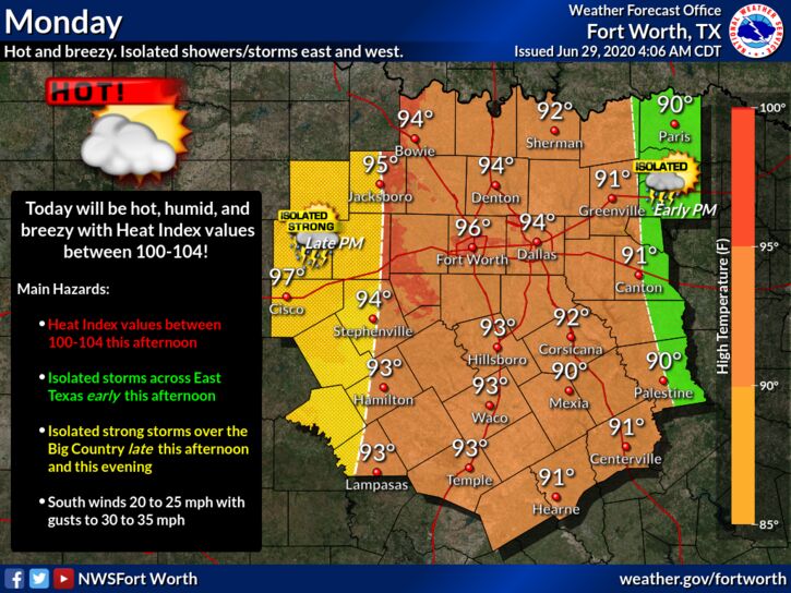 Hour by hour changes in the placement of showers and storms are determined by small scale weather features that are impossible to pinpoint well in advance. Otherwise, temperatures will be at around seasonal averages this week, around the mid 90s with the heat indices well in the triple digits.
HOLIDAY WEEKEND: Not much change. Look for partly sunny hot, humid days with highs in the mid 90s with heat indices in the triple digits. Chance of an isolated storm on Saturday. NEXT WEEK: Annnddddd, the same pattern rolls along. The same forecast ensues with hot, muggy days with highs in the low to mid 90s with heat indices in the triple digits. TROPICS: Shower and thunderstorm activity associated with a tropical wave located over the central tropical Atlantic has increased during the past few hours. Some slight development of the wave is possible during the next day or so while it moves westward to west-northwestward at around 20 mph. Strong upper-level winds are forecast to inhibit further development by mid-week. And, an area of low pressure is forecast to form off of the southeastern coast of the United States on Tuesday. Some development of this system could then occur later this week as it moves generally northeastward well offshore of the east coast of the United States. The rest of the Atlantic basin is quiet. ON THIS DAY IN 1998: “The Corn Belt Derecho of 1998” in the following states NE, IA, IL, IN, KY. A derecho which originated in far southeast South Dakota moved across Illinois during the afternoon and evening and continued as far east as Ohio the next morning. Every county in central Illinois sustained some damage, as these severe thunderstorms passed. Winds gusted in the 60 to 80 mph range, with some localized microbursts producing winds more than 100 mph. Significant damage occurred in the microburst areas, including the towns of Morton, McLean, LeRoy, and Tolono. In Tolono, 22 cars of a southbound 101-car Illinois Central freight train were blown off the tracks. It was unknown how many vehicles were picked up by the wind, but 16 cars were turned over, and another six derailed but remained upright. The train was en route to Centralia from Chicago with a load of mixed freight, including plastic pellets and meal. The freight cars empty weighed about 60,000 pounds, while a full one weighs about 260,000 pounds. Overall, 12 people were injured, and damage was estimated at around $16 million. Look for the next blog update at around noon tomorrow... Enjoy the day! Donovan Neal Owner - ApexStorm 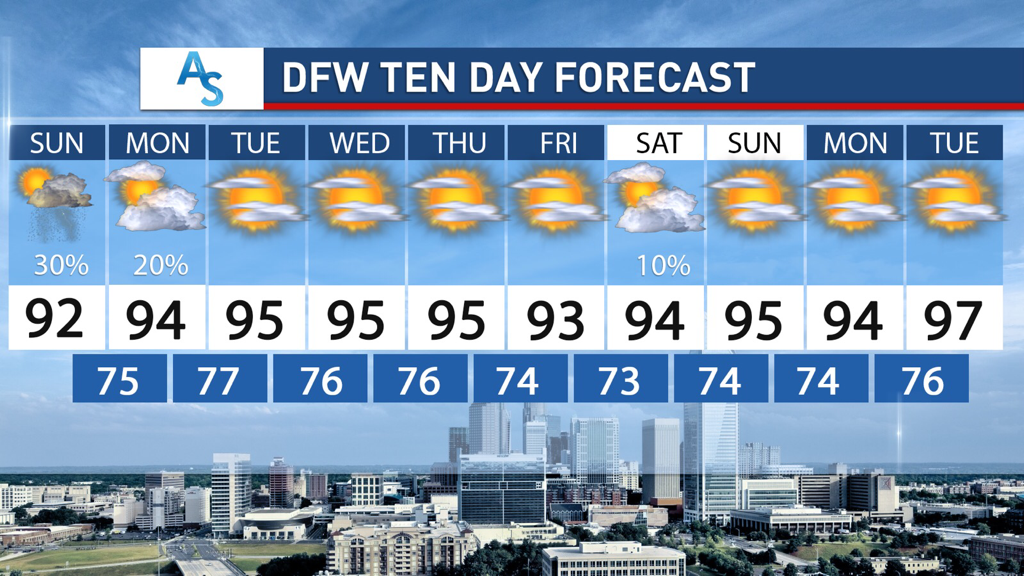 SAHARAN DUST:
Hope everyone has been enjoying the last few days of dryness! As you all know, Saharan Dust has made its way to North Texas and briefly impacted our air quality. The haze in the sky is attributed to the dust and will disappear within the next 24 hours. It has made for some really pretty sunsets as a plus, however. What is there to look forward to after the dust? STORM CHANCES: We will have some low storm chances as a result of increased northwest flow aloft potentially allowing for some complexes to develop on Sunday/Monday. These storms will be scattered if they develop and with even a potential severe risk if the cap breaks quickly enough on Sunday with the weak disturbance. The potential is low but nonzero. In addition, currently a chance exists for Thursday as well but there is less confidence for later in the week while we wait for the conditions to become more favorite and understood for the ability to produce these complexes. OTHERWISE: Expect this week to be a typical June week. There will be plenty of temperatures in the 90s but we aren’t expected to reach triple digits in the next week. It will likely be quite humid, however, so be mindful of heat indices that are stronger than normal. This pattern is capable of producing rain as well as producing sunny, humid weather. Not too much to really talk about, but there will likely be chances for people to enjoy the outdoors and hit the local pools. Stay dry, stay cool, and stay weather aware! -Colin Welty HUMID JUNE DAYS: Very moist air will hang over North Texas for the foreseeable future, and we will still mention the chance of isolated to widely scattered showers and storms, mainly during the afternoon and evening hours today. Most of them (not necessarily all) will come at around the noon to 9:00 PM timeframe, and the chances of any one spot getting wet is about one in five. With a Bermuda High in place across the southeast, the Plains will experience a tightening gradient. Meaning, warm and breezy weather conditions will continue through the weekend, and any showers and storms will become more isolated. Saturday should be mostly dry, but isolated showers associated with a weak shortwave is possible on Sunday. Otherwise, the weekend should be mostly dry with afternoon highs in the 90-93° range.
NEXT WEEK: Not much change. The main jet stream should remain well to the north of Texas, so, very humid air stays in place. Look for mostly sunny days with highs somewhere in the 90-95° range and increasing heat indices by Tuesday. An overhead northwest flow could develop by midweek, which could open the door to complexes of showers and storms both Thursday and next Friday. Due to natural uncertainties, we will only mention a small chance of rain during these days. TROPICS: The Atlantic Basin remains very quiet, and tropical storm formation is not expected through next week. DUSTY DAYS: THE SAL (Saharan Air Layer) covers North Texas today. The dust, with origins from the African continent, is mostly several thousand feet off the ground, and will give the sky a hazy appearance. There can be some reduction in air quality, but it will not impact most people. We had some glorious sunsets last night over North Texas, and expect the same this evening due to the scattering of the sunlight. The SAL moves into the Southern US just about every year. This is nothing unusual, and no “emergency” despite some of the media hysteria. ON THIS DATE IN 1957: Hurricane Audrey was in the western Gulf of Mexico; a category three storm. Landfall would come the following day, June 27, between the mouth of the Sabine River and Cameron, Louisiana,. It would go on to cause unprecedented destruction across the region. Prior to making landfall, Audrey severely disrupted offshore drilling operations in the Gulf of Mexico. Damages from offshore oil facilities alone was estimated at $16 million. Damage from the surge alone extended 25 miles inland. The rough seas killed nine people offshore after capsizing the boat they were in. Further inland in Louisiana, the storm spawned two tornadoes, causing additional damage. Audrey also dropped heavy rainfall, peaking at 10.63″ near Basile. In Louisiana and Texas, where Audrey first impacted, the damage toll was $128 million. The total death toll was 416. Look for the next blog update by Colin Welty tomorrow... Enjoy the day and have a great weekend! Donovan Neal Owner - ApexStorm RADAR CHECK: The weather radar is very quiet across the North Texas region this morning. There is convection near the Houston area with Flash Flood Warnings in effect to the west of Houston. That rain will move north this morning, which will initiate the chance of isolated, mostly afternoon and evening showers and storms for areas to the south of I-20 and to the east of I-35. Otherwise, the sky is mostly sunny with temperatures in the upper 70s to low 80s. The high will be just at the 90° mark for most communities; the average high for DFW on June 25 is 93°. FRIDAY AND THE WEEKEND: For those to the southeast of the metroplex, showers to the south and east will eventually thin out with time, but, we will still need to maintain the chance of scattered showers and storms during the afternoon and evening hours. Most of them (not all of them), will come from around 12:00 to 9:00 PM, and the odds of any one spot getting wet is about one in five. No way of knowing exactly where and when the storms form. You just have to keep track of radar trends. Highs will generally be in the 90-93° range. NEXT WEEK: Not much change in the weather is expected through next week. Partly cloudy, hot, humid with highs in the low to mid 90s. Dewpoints will continue to be in the 70s, so we will have to mention increasing heat indices. Many places will see heat indices in the 100-105° range by Tuesday or Wednesday.  TROPICS: The Atlantic Basin remains very quiet, and tropical storm formation is not expected over the weekend.
AFRICAN DUST: The SAL (Saharan Air Layer) has moved up into the Gulf Coast region this morning, and will cover more of North Texas tomorrow and over the weekend. This is dry, dusty air that originated over the African continent a couple of weeks ago, and can make the sky rather hazy. There will some reduction in air quality, but it won’t bother most people. The dust will scatter sunlight, bring potential for vivid sunrises and sunsets. This is not unusual, and it happens just about every summer. The size of this SAL is larger than usual, however. ON THIS DAY IN 1967: Three, F3 tornadoes crossed the Netherlands on this day. The first tornado touched down at 4:17 PM in Oostmalle. This storm destroyed the church and the center of the village. More than half of the 900 homes in the community were damaged with 135 completely gone. The second tornado touched down near Ulicoten and tracked northward through woodlands area. This storm killed two people at a camping site near Chaam, Netherlands. The third tornado destroyed 50 houses in Tricht, killing five and injuring 32 others. Look for the next blog update at around noon tomorrow... Enjoy the day! Donovan Neal Owner - ApexStorm MOSTLY SUNNY MORNING: We have a decent supply of sunshine over most of the region this late morning, and we have rain falling for a decent area in the southeast. Occasional showers and storms will be possible this afternoon and evening, and should not be a washout.
Highs will be in the upper 80s and low 90s today through Friday in wake of a very weak front stationary over Southern Texas, but it will sure be very moist. The average high for DFW at around this time of the year is 93°. A retreating warm front on Friday should pull enough moisture back into the region to mention the chance of isolated, mostly afternoon and evening showers and storms. The sky will be partly cloudy with highs in the low 90s. THE WEEKEND: As a classic, summertime ridge starts to build over us, we will forecast classic late June weather for the weekend; mostly sunny with highs in the low 90s. Showers will continue thin out Saturday, and should completely thin out on Sunday as thee air becomes drier. NEXT WEEK: Classic late June/early July weather continues. That being said, the increasing concern will be heat index values, starting over Central and East Texas Monday afternoon. Highs will be in the low to mid 90s, but, heat indices will be in the 100-105° range for those areas as a result of dewpoints in the mid to upper 70s. This oppressive heat will make its way to the rest of the North Texas region by Tuesday or Wednesday afternoon. This is the classic summertime weather here in Texas, so get ready for the annual oppressive heat as we head into Independence Day weekend and the middle of summer. HI DOLLY, BYE DOLLY: Tropical Storm Dolly formed yesterday, several hundred miles to the east of the US Coast. It has already been downgraded to a remnant low, and should completely dissipate tomorrow with no threat to land. The rest of the Atlantic Basin is quiet. SAL LAYER: The dry, dusty Saharan Air Layer (SAL) coming off the African continent is moving up into the Gulf Coast region, it will be place across Southern US for a few days giving us potential for some vivid sunrise/sunset views due to the scattering of sunlight. The dry air also means no risk of tropical storms or hurricanes over the Gulf for the next week or so. There could be some reduction in air quality, but most of the dust is several thousand feet aloft and most folks won’t even notice it. It happens just about every summer… nothing unusual. ON THIS DAY IN 1975: An Eastern Airlines Boeing 727 crashed at JFK airport in New York City. 113 of the 124 people on board the aircraft died. Researcher Theodore Fujita studied the incident and discovered that a microburst caused the crash. His research led to improved air safety. The tower never experienced the microburst, which was held back by a sea-breeze front. The plane crashed 2,400 feet short of the runway. Look for the next Texas Weather Blog Update at around noon tomorrow... Enjoy the day! Donovan Neal Owner/Founder - ApexStorm RAINFALL TOTALS: As of 7AM this morning, here are the rainfall totals over the past 24 hours... Arlington 0.46 Corsicana 0.01 Dallas Love Field 0.51 DFW Airport 0.91 Denton 1.95 Fort Worth Alliance 1.44 Fort Worth Meacham 1.46 Longview 0.04 Lufkin T McKinney T Mineral Wells 0.01 Paris 1.10 Terrell 0.07 Wichita Falls Municipal: 2.45 So far, showers and thunderstorms are not materializing as of late afternoon, but that could change within an hour or so. A few isolated supercells could develop along a residual outflow boundary, capable of hail and strong straight-line winds. After midnight, a complex of severe thunderstorms capable of large hail and damaging winds may impact the region after midnight. Heavy rain is also possible. SPC maintains the standard "slight" risk (level 2/5) of severe storms for much of the metroplex through 7AM tomorrow. 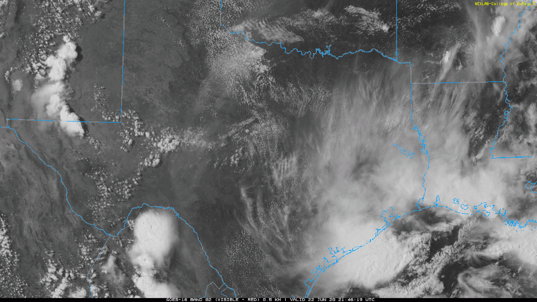 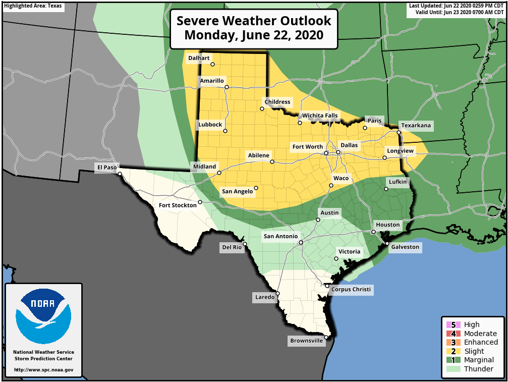 REST OF THE WEEK: An upper trough, combined with deep layer moisture, will keep our weather pattern unsettled through most of the week. Look for more chances of isolated to scattered showers and thunderstorms, mostly in the afternoon to overnight hours. Like tonight, severe storms are possible with wind and hail possible. The sky will be partly to mostly sunny with highs in the upper 80s to low 90s. Showers will be possible Thursday and Wednesday afternoon, but, they will be fewer in number.
THE WEEKEND: Look for a mostly sunny sky with the chance of an isolated shower and storm or two. Highs will stay close to 90° over the weekend. NEXT WEEK: We will stick with the classic summer forecast for much of the week; mostly sunny skies, highs in the 93-95° range. TROPICS: Shower and thunderstorm activity associated with a well-defined low pressure system located about 350 miles southeast of Cape Cod, Massachusetts, has continued to get better organized today, and a subtropical depression has formed this afternoon. The system is expected to move to the east/northeast, staying away from the US at this time. The rest of the Atlantic Basin is quiet. AFRICAN DUST: The SAL (Saharan Air Layer), with origins over the deserts of Africa, is pushing through the Caribbean this morning, and should reach parts of the southern U.S. later this week. This dry, dusty air is transported in high levels of the atmosphere, generally between 5,000 and 20,000 feet, and the main effect is creating very vivid sky scenes at sunrise and sunset due to the scattering of sunlight. The dry air also mitigates any tropical storm formation. There can be a reduction in air quality, but most of the dust is several thousand feet off the ground and is not an issue for most people. And, this is NOT unusual in summer. ON THIS DAY IN 2007: The first officially documented F5 tornado in Canada struck the town of Elie, Manitoba population 500 people. Video of the storm showed a heavy van being whirled through the air. The storm also tossed an almost entire house several hundred yards through the air before it disintegrated. The tornado traveled across the landscape for about 35 minutes covering 3.4 miles and leaving a damage path 984 feet wide. Wind speeds in the tornado were later estimated at 260-316 mph. Fortunately, no fatalities or serious injuries were reported. 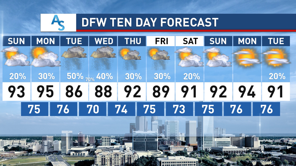 SUMMER STORMS:
After weeks of dry, hot, summer weather, much of DFW saw a return to rain on Friday. Some isolated areas got upwards of 5 inches overnight, with most areas getting at least an inch of rain. While we returned to clear skies for the weekend we can expect this new rain trend to continue for the next week. The pattern has shifted from our dry spell and, due to our NW flow, more shortwaves will come this week with rain totals that could exceed 5 inches for parts of North Texas. EARLY WEEK: A low pressure system will move down the Texas Panhandle on Monday and produce a shortwave that will move southwest into DFW producing a MCS which could dump a major amount of rain on Tuesday and Wednesday for North Texas. There are varying model solutions for those two days but it is likely that storms will come in late Tuesday and persist overnight through Wednesday. The European model is extremely aggressive and shows bands capable of producing over 10 inches of rain for parts of Texas and it is unlikely that a solution like that unfolds, but could develop if all the right conditions are in place. I’m leaning towards only 2-3 inches for DFW but it’s important to monitor what will happen as the low pressure system moves over Texas and as the shortwave develops. In addition, temperatures will be, on average, 5-10 degrees cooler than the weeks beforehand, with Tuesday potentially struggling to get past 85 degrees. While this will be accompanied by humid weather, potentially raising the heat index, it’ll hopefully be a nice change for us. LATE WEEK RAIN: Rain is possible for the rest of the week as well with multiple chances for scattered thunderstorms through next weekend. The shortwave coming through early next week is a side effect of the larger trough that will position itself over Texas for the next week, creating favorable conditions with an active southern jet. While it is currently forecasted for Central and Southern Texas to get more rain than North Texas through the end of the week, it’s extremely possible that there is enough rain to push DFW over the average rainfall for the month—a stark contrast from how dry and hot the month started. Temperatures will also stay within the mid to high 80s in the day and 70s overnight, feeling more like August in Hawaii than June in Texas. It’ll be a refreshing change of pace for sure! Stay dry, stay cool, and stay weather aware! -Colin Welty NORTHWEST FLOW ALOFT: Moisture levels will begin to slowly increase today through next week as a northwest flow aloft builds across the South-Central US which will open the door for moisture, resulting in more chances of scattered showers and storms, MCS's, and more clouds. A complex of thunderstorms from Oklahoma and West Texas will gradually weaken and move into portions of North Texas after midnight. Not everyone will see rain, but the greatest chances lie for those closest to the Red River. Otherwise, we project a high in the 91-94 degree range this afternoon with the chance of isolated, mostly afternoon and evening showers and thunderstorms. Another complex of showers and storms will emerge from South Oklahoma and move south overnight on Saturday, arriving to most of the metroplex by daybreak Sunday. Each afternoon will feature highs in the low 90s with a mix of sun and clouds and fair nights. An afternoon shower or two can not be ruled out, but, odds of any one spot getting wet are only 10 percent during the afternoons. NEXT WEEK: Moisture levels continue to be above normal, and we will continue to insert daily chances of "isolated, mostly afternoon and evening showers and storms". Afternoon temperatures each day will be in the low 90s due to cloud cover and showers. Rain distribution will not be even, but many communities have a chance of seeing 1 to 1 1/2 inches during the week. 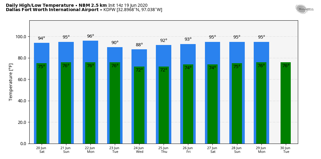 TROPICS: The Atlantic Basin remains very quiet, and tropical storm formation is not expected through next week. The SAL (Saharan Air Layer) could reach the Southeastern US by next week, setting the stage for vivid sunrises and sunsets, especially along the coast.
ON THIS DAY IN 1972: Hurricane Agnes deluged Pennsylvania and New York with torrential rains resulting in the most costly flood in U.S. history. In the Middle Susquehanna Valley of Pennsylvania, 24 hour rainfall amounts were generally 8 to 12 inches, with up to 19 inches in Schuylkill County. At Wilkes-Barre, the dike was breached, destroying much of the town. Flooding resulted in 117 deaths and $3.1 billion in damage. Look for the next Texas Weather Blog here tomorrow from Colin Welty... Have a great weekend! Donovan Neal Owner - ApexStorm RADAR CHECK: We do have a few showers across South Texas this afternoon, but they are few and far between, as forecast. Most of the state is dry with mostly sunny skies and temperatures in the 90s. 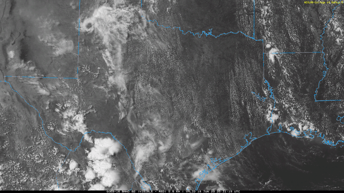 Showers will gradually diminish after sunset, and tonight will be mostly fair with lows in the mid 70s. A weakening MCS will spit out of Oklahoma through the overnight hours, and will eventually make it into at least the Northwest Texas region during the morning. We will introduce the chance of scattered showers and thunderstorms through the morning and afternoon before sunset. Some of the more isolated storms may become strong to borderline severe during the peak of the daytime heating process, so the SPC has issued a "marginal" risk (level 1/5) of severe storms for the western parts of the region. 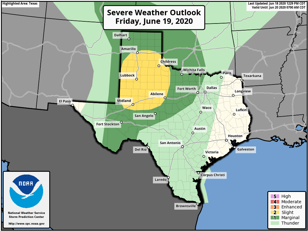 Not everyone will see rain, but, some downpours are possible due to high precipitable water values. Everyone else will be partly sunny through out the day with highs in the low 90s. THE WEEKEND: Another MCS will develop along the Red River through the late morning, and move southeast through the metroplex as it weakens. Through its weakening trend, scattered showers and thunderstorms will be possible during a small window from 11-5PM. The morning will feature partly to mostly sunny skies. Highs in the afternoon will stick to the low 90s. Afternoon showers remain more isolated on Sunday, and highs should continue to be around the low to mid 90s. NEXT WEEK: With the projected northwest flow in the upper pattern, the pattern will remain unsettled with daily chances of "scattered, mostly afternoon and evening showers and storms". If you have lived in North Texas long enough, you should know that there is really no way to predict when or where these storms initiate and linger due to the random, scattered nature of the storms; you just have to make sure to keep an eye on the radar if you are slated to participate in any socially-distant outdoor activities. 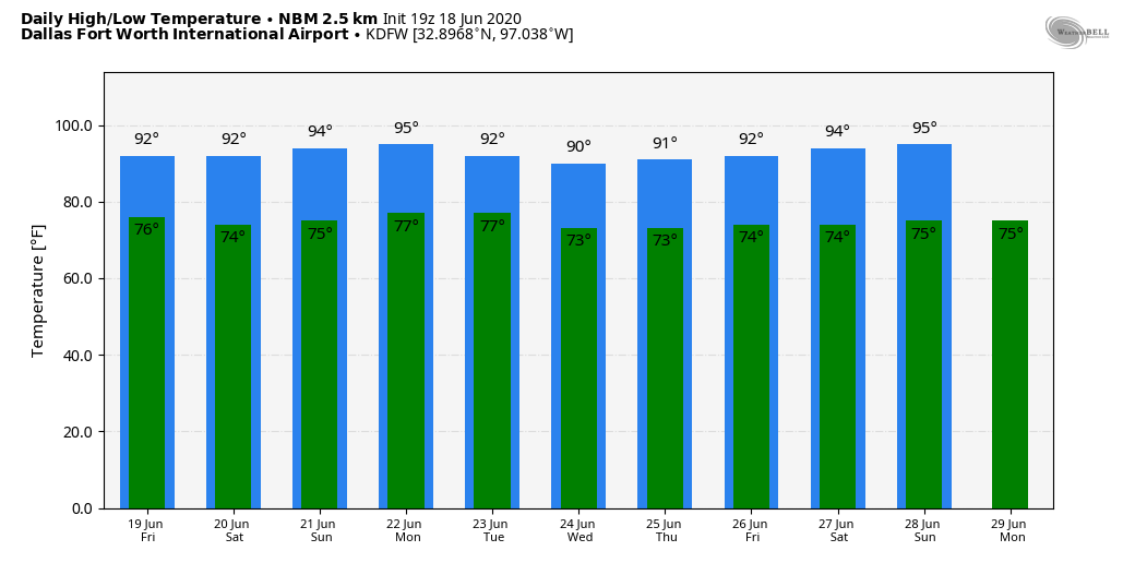 TROPICS: All is quiet in the Atlantic Basin, and tropical storm formation is not expected through the weekend.
ON THIS DAY IN 1989: Unseasonably hot weather prevailed in the southwestern U.S. In Arizona, afternoon highs of 103 degrees at Winslow, 113 degrees at Tucson, and 115 degrees at Phoenix were records for the date. Look for the next Texas Weather Blog before noon tomorrow... Enjoy the evening! Donovan Neal Owner - ApexStorm Here are some late afternoon temperatures across the DFW Metroplex... FW AIRPORT 93 DALLAS LOVE 94 FTW MEACHAM 92 DAL-EXECUTIVE 94 FTW-ALLIANCE 94 FTW-SPINKS 95 ARLINGTON 95 GRAND PRAIRIE 91 ADDISON 93 MESQUITE 93 LANCASTER 93 The average high for June 17 is 92°, so a number of communities around the metroplex are around or just above our seasonal average for this time of the year. The sky is mostly sunny, and storms to the east are few and far between. 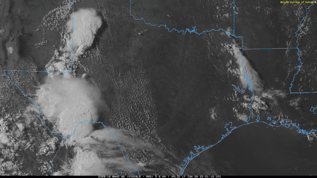 TOMORROW THROUGH THE WEEKEND: The weather will not change much tomorrow. Look for mostly sunny skies with a few widely isolated showers and storms, mainly for our eastern counties. The high will be in the low to mid 90s. Then, on Friday, a mesoscale convective system (MCS) could develop in Oklahoma, and make it to parts of the metroplex as it gradually weakens through the evening and overnight hours. Saturday will feature much of the same boring dry weather. Then, on Sunday, a mid June cold front makes its way to the area, which will subsequently raise our daily chances of scattered, mostly afternoon and evening showers and thunderstorms through at least the beginning of next week. There is a chance that a couple of storms on Sunday could be strong to severe during the peak of daytime heating. Temperatures will stay in the mid 90s with increased humidity. NEXT WEEK: Global models continue to hint the idea of increased coverage of scattered showers and thunderstorms each day as the air becomes more unstable, and the humidity continues to rise. Highs will be in the low to mid 90s with a mix of sun and clouds each day. 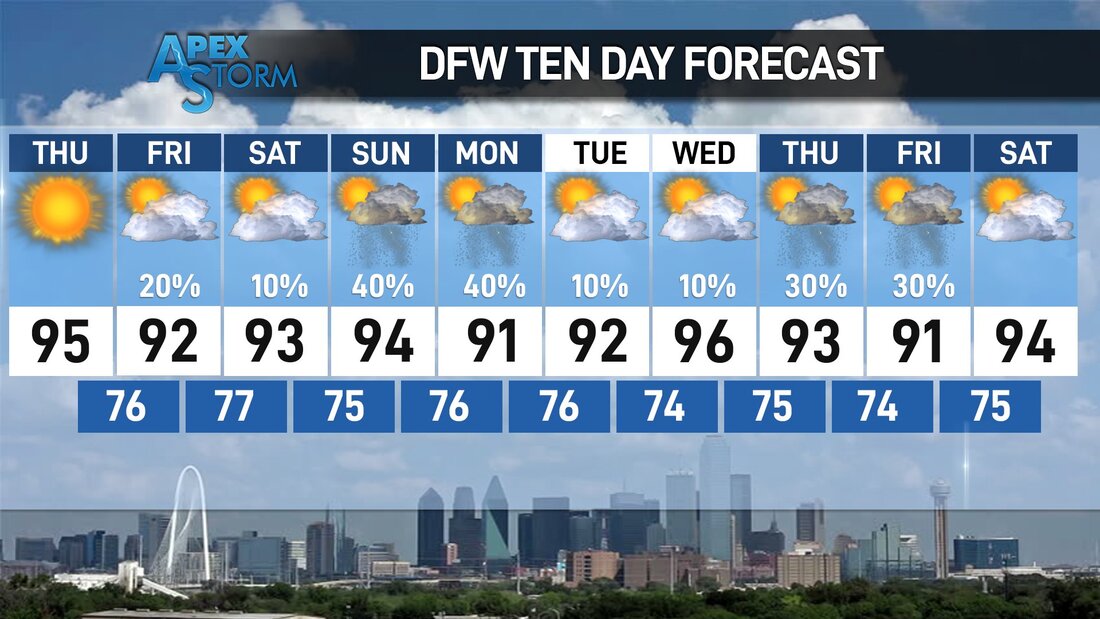 TROPICS: Dry, dusty air from the African deserts will move across the Atlantic in the coming days, eventually reaching the Southeast US by next week. This can set the stage for very vivid sun rises and sunsets, and it also means that no tropical storm formation is expected for the foreseeable future. The peak months of the Atlantic Hurricane Season is usually in August and September. The next named storm will be "Dolly".
ON THIS DAY IN 1882: A tornado traveled more than 200 miles across the state of Iowa killing 130 persons. The tornado traveled at nearly 60 mph and touched down about 90 miles west of Grinnell, struck the town and college around sunset, killing 60, and caused more than half a million dollars damage. RADAR CHECK: We have isolated showers and thunderstorms about to the east of the metroplex as humidity levels continue to increase over time. The sky is mostly sunny, and temperatures are around the low 90s across North Texas. The average high for DFW Airport for June 16 is 92°. 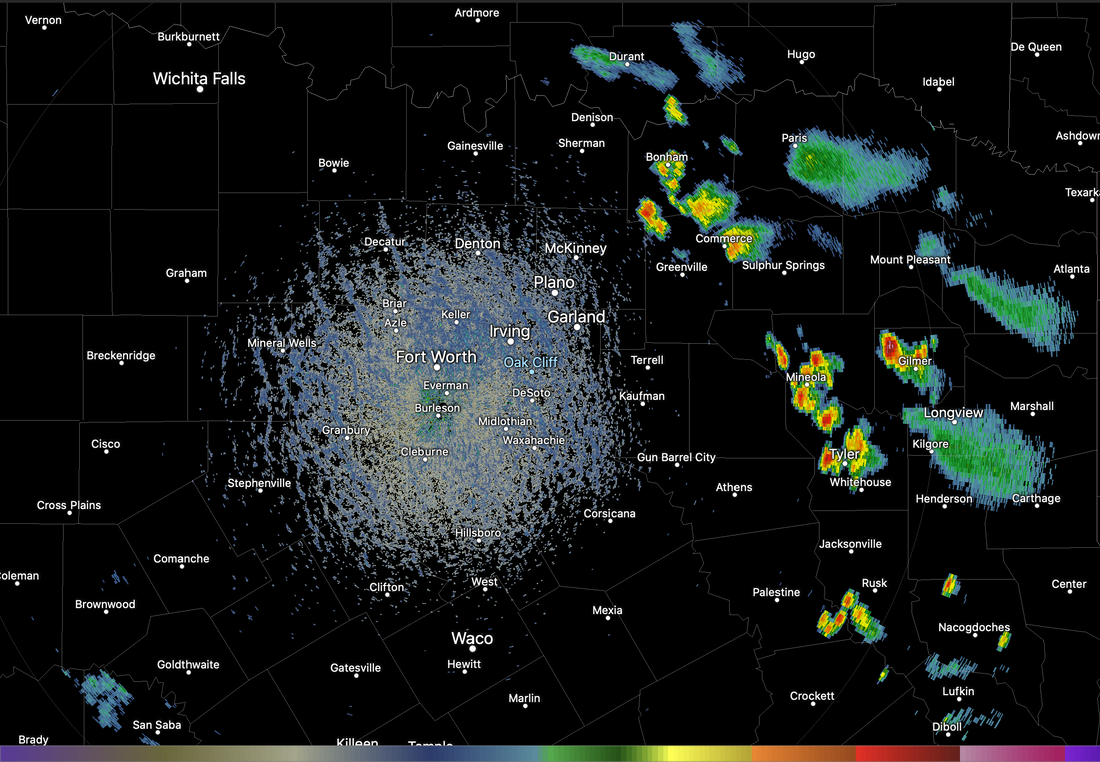 Those thunderstorms should dissipate during the overnight hours, and tonight will be mostly fair with lows in the low 70s. Some of the cooler spots will visit the upper 60s again. TOMORROW THROUGH FRIDAY: Look for partly cloudy days and fair nights. A shower or storm could pop up, but they will remain few and far between. Most places will remain dry. Highs will be in the mid 90s for the rest of the workweek. Humidity levels will continue to rise. THE WEEKEND: We expect afternoon highs in the 92-97° range over the weekend with a good supply of sunshine. On Father's Day, we will mention the chance of scattered, mostly afternoon and evening showers and storms. No telling where the storms form and who gets rain. Just know that there is a 1 in 3 chance of getting wet on Sunday. NEXT WEEK: During the beginning of the week, the pattern begins to shift, allowing deeper moisture to make it into the state, increasing the chances of isolated showers and storms for the beginning of the week. Highs will be in the mid 90s, lows in the mid 70s with a mix of sun and clouds each day. 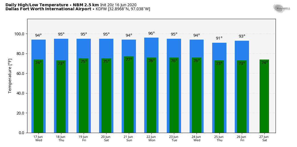 TROPICS: A non-tropical low-pressure area located about 150 miles south-southeast of the North Carolina-South Carolina border continues to produce disorganized showers and thunderstorms over portions of southeastern and eastern North Carolina, including the Outer Banks, and adjacent Atlantic waters. The low has moved little today, but a slow northward motion is forecast to begin by this evening. Environmental conditions are expected to remain unfavorable for significant development through tonight when the low should move inland over eastern North Carolina. Regardless of development, heavy rainfall could occur over portions of northeastern South Carolina and southeastern and eastern North Carolina through tomorrow. The rest of the Atlantic Basin is quiet.
ON THIS DAY IN 2014: a supercell thunderstorm would produce 5 tornadoes, one rated EF-0 and four rated EF-4, across northeastern Nebraska. The town of Pilger was hardest hit when it took a direct strike from one of the EF-4 tornadoes. The third EF-4 tornado, also known as “Pilger East” was likely the strongest tornado of the outbreak, but fortunately remained in rural areas. The most remarkable thing about this outbreak was the “twins”. Tornadoes 2 and 3 (known as Pilger and Pilger East respectively) became two photogenic twins, at times moving around each other, and crossing paths. After tornado 3 dissipated, tornado 4 (Wakefield) and tornado 2 were twins for a short period of time. Look for the next blog update at around the same time tomorrow... Have a great night! Donovan Neal Owner - ApexStorm Following our cold front earlier this week, temperatures and humidity have been tolerable for North Texas. However, the next few days the heat and humidity will crank back up a bit.
Your Sunday will feature a mix of sun and clouds with highs in the middle 90s, with increasing moisture. However, dry weather is anticipated. As we head into next week, it will start to feel pretty sticky again with highs in the mid to upper 90s and lows in the low to middle 70s. An overall calm week is expected, however a couple seabreeze showers and storms aren't ruled out especially on Tuesday & Wednesday. Coverage will be low and favor areas to the south and east of DFW. Each day will likely feature mostly to partly sunny skies. By next weekend, a pattern shift is expected. Our flow aloft will become dominantly NW flow. This will favor a couple shortwaves riding along the jet bring a chance of thunderstorms starting Saturday & Sunday and beyond. Given a greater S jet, some 500mb flow could be present allowing for at least a chance of strong storms. However, it is too far out for much detail or certainly. The most important think is that rain chances are expected to return, given how we have had little to no rain so far this month. The heat could also come to an end for a period of time, with highs back down into the 80s and low 90s expected. Have a great evening! Logan Shipley VERY COMFORTABLE AFTERNOON: A dry continental air mass continues to affect much of the state today, and we continue to enjoy sunshine in full force with lower humidity. Temperatures are around seasonal averages, mostly in the low 90s. Tonight will be clear and pleasant with lows in 60-66 degree range by daybreak.  TOMORROW THROUGH THE WEEKEND: Not much change in the overall weather pattern, as very dry air remains in place. Sunny, warm days with fair and pleasant nights. Afternoon highs will be in the low to mid 90s, with lows mostly in the mid 60s. Cooler spots will enter the 50s chat each morning. NEXT WEEK: How many times must I say it, but the June weather pattern continues. Highs will be in the mid to upper 90s for the foreseeable future as we see a slow rise in humidity levels. Weather will continue to stay dry with only an occasional isolated shower. 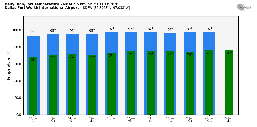 TROPICS: A disorganized complex of showers located 200 miles east of the Windward Islands is associated with a tropical wave. Significant development is not expected due to the unfavorable environment. The rest of the Atlantic Basin remains quiet.
ON THIS DAY IN 1915: The twister that hit near Mullinville, KS was a mile wide multi-vortex tornado that swept away an entire farm and threw a trio of mules a distance of two miles. However, the storm moved so slowly that people were able to get out of its way and there wasn't a single death or even an injury. DRY AIR IN NORTH TEXAS: As a result of a rare June cold front, dewpoints are lower than in recent days, followed by a fresh northwesterly breeze. The radar continues to be dry for this evening and tonight, and not many clouds are around, either.  We will have another cool night as dry air hangs around through much of the state. TOMORROW THROUGH THE WEEKEND: Dry air equals sunny days, cooler nights, and lower humidity tomorrow through Sunday. Highs will be in the low 90s, lows well into the 60s. Cooler spots may see lows in the 50s once again tomorrow. Very refreshing for this time of the year in North Texas. It will be a good break from high humidity and random pop-up storms. NEXT WEEK: The quiet weather continues. Highs will be in the 95-98 degree range. While humidity levels will slowly rise, widespread rain activity is not expected. We will just mention a couple of isolated showers over the course of the week.  TROPICS: A non-tropical low pressure is located over the central Atlantic Ocean, several hundred miles to the east of the Bermuda. Development of a tropical cyclone is not expected due to unfavorable environmental conditions. The low is forecast to dissipate tomorrow when it slowly moves to the west. The rest of the Atlantic Basin is quiet.
ON THIS DAY IN 1938: Clyde, TX suffered the effects of what was likely an F5 tornado. Several homes completely vanished. One family tried to escape the tornado by car, and inadvertently drove right into it when the twister made a sudden unexpected turn. Four of the six occupants of the car were killed. The two survivors were found half a mile away from the rest of the bodies. Look for the next Texas Weather Blog here by 4:00 PM tomorrow... Donovan Neal Owner/Founder - ApexStorm HOT TUESDAY: It was a very hot June day here in the metroplex and much of North-Texas. Here are some of the temperature readings at around 3PM... DFW AIRPORT 96 DALLAS LOVE 99 FTW MEACHAM 93 DAL-EXECUTIVE 98 FTW-ALLIANCE 94 FTW-SPINKS 99 ARLINGTON 99 GRAND PRAIRIE 99 ADDISON 97 MESQUITE 100 LANCASTER 99 In wake of a cold front, drier air and cooler conditions can be expected for the next few days. Overnight lows will be in the low 60s. Some of the cooler spots will see lows in the 50s. Some showers are possible in East Texas and the Brazos Valley. No severe storms, but the storms could produce heavy rainfall, and small hail. TOMORROW: After a rather rare June cold front, tomorrow will be a different kind of day. This morning, and early afternoon, we experienced dewpoints in the 70-75 degree range. Tomorrow, they will drop into the low 40s as much drier air takes over. We will be noticeably cooler with highs mostly in the upper 80s with a breezy northwesterly wind. The more south you go, the more of a chance you have of seeing low 90s. THURSDAY THROUGH THE WEEKEND: We will continue to enjoy lower humidity towards the end of the week with sunny days. Dry weather will continue through the weekend with sunny, warm days and pleasant nights. Cooler spots will drop to the 50s each morning, with low 60s generally across the board. NEXT WEEK: The weather pattern continues to look very quiet. Moisture levels slowly rise, and thus, a few showers could show up to the south over the latter half of the week, but no sign of any widespread rain for a very long time.  TROPICS: A non-tropical area of low pressure is located over the central Atlantic Ocean, a few hundred miles east of the Bermuda. Development of this system is highly unlikely due to unfavorable environmental conditions. The low is expected to dissipate in a few days. The rest of the Atlantic Basin is quiet.
ON THIS DAY IN 1953: An F4 tornado hit Worcester, MA causing 94 fatalities. The tornado touched down in Petersham, traveled through Worcester, and on to Southborough. Debris was carried eastward and fell in the Boston area. About 4000 houses and buildings were destroyed, totaling more than $52 million in damages. Look for the next blog update around the same time tomorrow... Have a great night! Donovan Neal Owner - ApexStorm RADAR CHECK: While all of the metro remains dry this evening, a couple of isolated thunderstorms continue to rotate through extreme Northeastern Texas this evening, on the west side of the circulation of Tropical Depression Cristobal, which is now over Southern Arkansas. A very moist airmass will continue to stay in place tomorrow as a "death ridge" continues to be in place over the region. We will warm to the upper 90s, and some places will see their first 100 degree day of the year. The average first 100 degree day in North Texas falls on the first of July. If we don't hit it tomorrow, it will be awfully close, for sure. Then, a rare June cold front will push into the region tomorrow afternoon, which will help to usher in drier air and breezier winds. The timing of the cold front will determine whether some spots see 100 degrees or not. One way or another, the drier weather combined with breezy conditions will spark fire concerns tomorrow afternoon and evening. WEDNESDAY THROUGH THE WEEKEND: A very dry airmass in wake of a cold front will slightly cool us off by a few degrees. Wednesday, Thursday, and Friday will be very pleasant days for June. Expect a good supply of sunshine, lower humidity, and cooler nights. Highs will be in the low 90s, but lows will be well down in the 60s, and cooler spots will hit the upper 50s. Not much change for the weekend as dry air continues to hang in here. The sky will be mostly sunny Saturday and Sunday with highs in the mid 90s and lows in the low 70s. NEXT WEEK: Moist air begins to make a return early next week. As such, we will bring back the chance of a random, isolated shower or storm on Monday, and keep it in the forecast on a daily basis through the end of the week. Highs will be in the mid to upper 90s on most days. 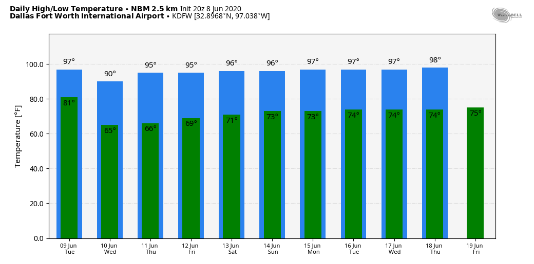 TROPICS: Tropical Depression Cristobal is over Arkansas and will continue to weaken. The rest of the Atlantic Basin is quiet, and tropical storm formation is not expected this week.
ON THIS DAY IN 2001: Tropical Storm Allison hits Houston for the second time in three days. Louisiana and Southern Texas were inundated with rain, as Baton Rouge received over 18 inches over a couple of days. Some portions of Texas accumulated 36 inches by June 11.  The past week has shown North Texas plenty of sunshine and heat, with more of that to come in the future. Aside from the few scattered storms last week, it was a mostly dry, hot week with days in the 80s and 90s, and looking forward, summer heat is the new normal for North Texas. What can we expect for the upcoming week?
CRISTOBAL Tropical Storm Cristobal, who is currently residing in the Gulf of Mexico, will be making landfall to our east in Louisiana and making its way up through the United States on Sunday through Tuesday. There is a fairly decent chance that the outer remnants of Cristobal make its way to DFW as a few rain bands rotate around our area as the low pressure system disperses. It’s not a given, as tropical storm paths are still difficult to predict even this close out, but the possibility still exists. Regardless, as a result of Cristobal, a spike in temperature will happen on Tuesday with our first possibility of triple digits this year. Compressional heating as a result of a dry air on the backside of the tropical storm, in a process called “subsidence”, will result in record heat for lots of Texas, and it’s possible we could also set records, depending on the speed of the incoming cold front as well. The cold front will only lower temperatures a little bit but it will drop dew points, making the air less muggy. “DEATH RIDGE” Many of you have heard talk of the so-called “death ridge” that has placed itself over the United States. What does this mean? In its most basic form, troughs are associated with low pressure systems and ridges are associated with high pressure systems. High pressure systems, especially in the summer, can lead to rising temperatures, whereas low pressure systems, commonly associated with cold fronts, cool the air, due to the interaction of the upper and lower dynamics of the atmosphere. The death ridge brings calm winds and strong cap inversions that make all moisture in the area unable to form as rain clouds, creating hotter, more intolerable days. Thankfully, if we have a death ridge, it is quite mild, as temperatures likely won’t break triple digits aside from after the tropical storm. There will also be a number of chances for low pressure systems to come in and potentially give us relief later on the week, though that is less likely at this point in time. For the foreseeable future, DFW will be subject to dry, 90 degree days with plenty of sunshine, for everyone to enjoy whatever pool they can socially distance themselves at. Stay cool, stay hydrated, and stay weather aware! -Colin Welty ANOTHER QUIET MORNING: After a round of strong to severe storms overnight for some of our northwestern counties, we are dry once again this morning. The forecast will not change much for the foreseeable future; each day will feature mostly sunny skies with increasing humidity. Highs will today will be in the upper 90s. Heat Indices will be in the danger zone once again today, exceeding the triple digits. THE WEEKEND: Not much change. Much of the same weather continues for the weekend with relatively dry weather tomorrow and Sunday with a great supply of sunshine and afternoon highs around the upper 90s. Showers will be pretty unlikely for the weekend. NEXT WEEK: Very humid air will cover the region for the beginning of next week, as Cristobal passes to the east, continuing to leave us in a very dry, humid airmass. We might experience a few isolated showers and storms on Monday, but, we will quickly warm on Tuesday. There is high confidence that Tuesday might be DFW's first official 100 degree day of the year. The average first 100 degree day for DFW is usually July 1, so we are way ahead of schedule. Heat indices will likely reach the danger zone once again on Tuesday, so a Heat Advisory will likely be needed to address this concern. The rest of the week will feature more dry weather with highs in the mid 90s. 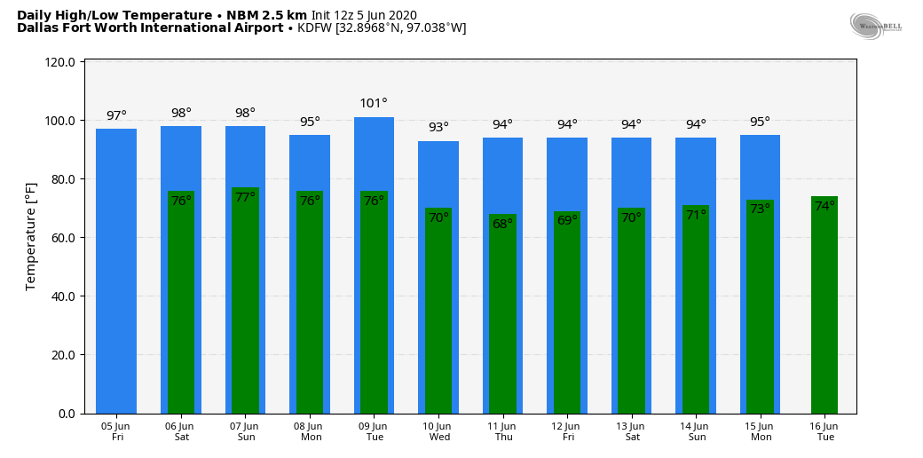 CRISTOBAL: The system is still inland this morning over the Yucatan of Mexico. It is a tropical depression with sustained winds of 35 mph. It will begin its journey northward into the Gulf of Mexico tonight, and should regain tropical storm status. No real change has been made to the NHC forecast track; landfall will take place Sunday night along the Louisiana coast as a tropical storm. 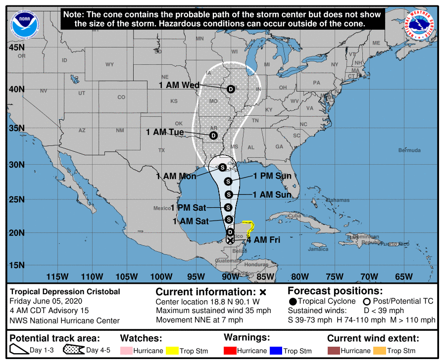 Hurricane strength is unlikely, as the system will soon encounter dry air and moderate shear. Tropical storm watches will be required for portions of the Gulf later today.
ON THIS DAY IN 1976: When water began leaking from Idaho's new Teton Dam, there seemed to be no cause for alarm. On this date, warnings were frantic that the dam was about to break. As workers tried to shore up the crumbling dam, it crumbled shortly after 11 AM, sending 180 billion gallons of water pouring through Teton Canyon. 11 people lost their lives, but the toll would have been much higher if the dam had failed at night and residents had been asleep. Look for the next blog update tomorrow by Logan Shipley... enjoy the day! OCEAN OF HUMIDITY: A hot, muggy airmass will hang over North Texas for the foreseeable future, meaning each day, we will forecast partly to mostly sunny skies, which a chance of a random isolated shower or storm. There isn't a way of knowing exactly who will get the storm, just remember to check the radar from time to time. The radar will be very quiet this afternoon, but a weakening complex of severe thunderstorms will move southeast overnight, and rain is possible in some areas by 1PM. Highs will be in the mid 90s, seasonably warm for the beginning of June. THE WEEKEND: No real chance for the weekend. We remain dry, humid, and hot with mostly sunny skies on both days. Highs will continue to be in the middle to upper 90s. NEXT WEEK: We will introduce a chance of scattered showers and storms on Monday as Cristobal moves northward through Louisiana and Arkansas, but the general pattern will not change much. Mostly sunny, hot, humid days with mostly dry conditions. Highs will remain mostly in the middle to upper 90s through the week. There is some hint that one of those days could be the first 100 degree day of the year, but we will believe when we see it. 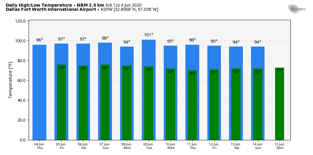 TROPICAL STORM CRISTOBAL: This morning, the system continues to weaken, as winds are down to 40 mph. The center of Cristobal was located over Southern Mexico, and is nearly stationary... A movement toward the east then northeast is expected later today, and a subsequent northward motion should occur through the weekend. On the forecast track, the center will move over the landmass of eastern Mexico today and tonight. The center is then forecast to move back over the Gulf tomorrow or tomorrow night, then the Central Gulf on Saturday. No significant change has been made to the NHC forecast track. The tropical storm is expected to move into the Louisiana coast Sunday night with winds of 60-65 mph. 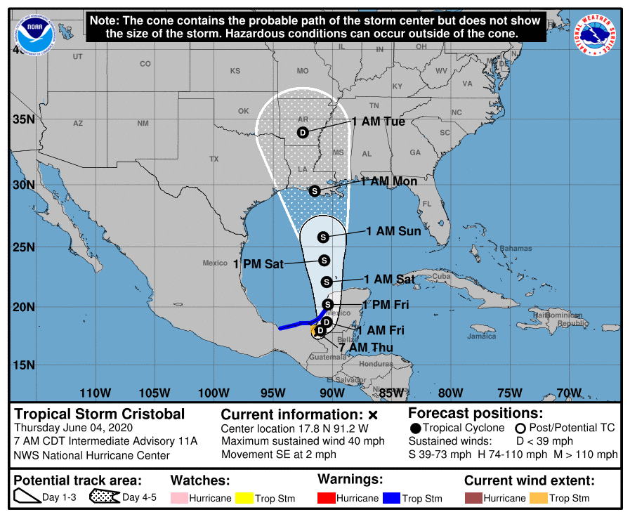 The circulation center will move through Louisiana and Arkansas Monday and Monday night, whilst weakening.
ON THIS DAY IN 1877: A tornado of F4 intensity touched down just to the west of Mt. Carmel, Illinois and moved northeast, devastating the town. 20 businesses and 100 homes were severely damaged or destroyed. 16 people and as many as 30 were killed, with 100 injured. Look for the next blog post tomorrow at around the same time... Enjoy the day! Donovan Neal Owner/Founder - ApexStorm HOT, HUMID DAYS: The radar is quiet across North Texas this morning, but we expect the return of isolated showers and thunderstorms this afternoon, accordingly. Most of the showers will come from around 12:00 to 9:00 PM, and the chance of any one spot getting wet is about one in three. The high will be in the low to mid 90s. There will not be much change tomorrow and Friday. Warm, humid days with "isolated, mostly afternoon and evening showers and storms". There is no way of exactly knowing when and where the storms appear due to the random nature. You just have to ensure to keep an eye on the radar if you have outdoor activity planned. Highs will remain in the 92-95 degree range. THE WEEKEND: Not much change; We will continue to roll with the persistent early summer forecast of "mix of sun and clouds with daily chances of isolated, mostly afternoon and evening showers and storms". Highs will be in the middle to upper 90s. NEXT WEEK: We expect an increase in the amount of showers and storms on Monday and Tuesday as a response of the tropical moisture being pulled to the north due to Tropical Storm Cristobal. The highest coverage will most likely come on Monday as Cristobal passes to the west of the state, on its journey northward. Highs will be in the low to mid 90s, lows in the mid 70s. 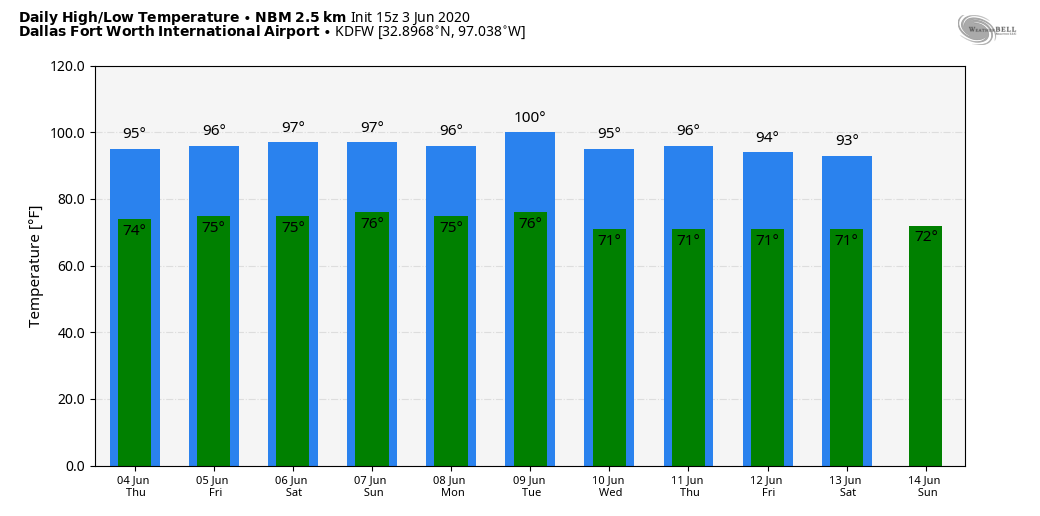 TROPICAL STORM CRISTOBAL: The system in the far southwestern Gulf of Mexico is packing sustained winds of 60 mph this morning. According to the forecast track, the center will cross the southern Bay of Campeche coast later today and move inland over eastern Mexico tonight and tomorrow. The center is then forecast to move back over the Bay of Campeche tomorrow night and Friday. Slight increase in strength is possible until the center crosses the coast, which, at that point, will weaken once again. Restrengthening is expected after Cristobal moves back over water tomorrow night and Friday. The latest NHC track places Cristobal on the Louisiana coast Sunday night as a high-end tropical storm. The main impact will come from heavy rain, flooding, and waterspouts/tornadoes. 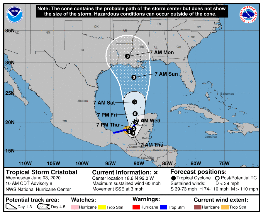 ON THIS DAY IN 1993: (This is something North Texans should be familiar with) Early morning severe thunderstorms produced huge hail across northern Oklahoma. Hail, up to the size of six inches in Enid, went through roofs, damaged three fighter jets at Vance Air Force Base, and did $500,000 in damage at a car dealership. Wind gusts reached 70 MPH at the base as well. Hail damage to crops was estimated at $70 million.
Look for the next blog update at around the same time tomorrow... Enjoy the day! Donovan Neal Owner/Founder - ApexStorm WARM JUNE WEATHER: We are forecasting a high in the upper 80s to low 90s for most North Texas communities today. The sky will be partly cloudy, and the best chance of isolated showers and storms this afternoon will lie over the northeast corner of the region. The average high for Dallas/Fort-Worth on June second is 88. The ridge will continue to build through the rest of the week, and we will bring rising temperatures to the forecast again. We will remain mostly dry with a mix of sun and clouds each day. We will gradually get hotter with afternoon highs ranging from the low to mid 90s with overnight lows generally in the middle 70s. THE WEEKEND: Not much change. Typical weather for early June should continue with warm, humid conditions. There could be a slight uptick in moisture levels with a slight chance of scattered showers and thunderstorms on Sunday, depending on the track of the tropical system in the Gulf of Mexico. Mix of sun and clouds with highs in the 90s. NEXT WEEK: Again, our weather will be largely dependent on the tropical situation. If the system moves into Louisiana, or Southeast Texas (as it appears now) and stays to the east, the week will be warm with a mix of sun and clouds daily with highs in the 90s. Otherwise, expect an uptick of moisture with a chance of scattered showers and thunderstorms for at least the beginning of the week. 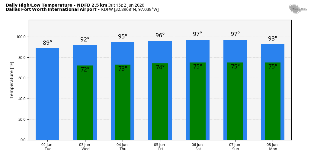 TROPICAL DEPRESSION THREE: The third tropical depression this year developed late yesterday over the Bay of Campeche in the far Southwest Gulf of Mexico. It is expected to become Tropical Storm Cristobal today, and it will move very little, if, at all, over the next 48 hours. The system will then move northward this weekend, and the NHC forecasts the center to be over the Gulf of Mexico by Saturday night. 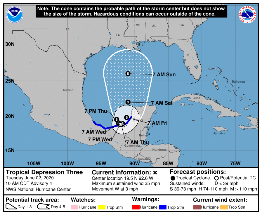 From there, higher landfall probabilities lie over the upper Texas and western Louisiana coast Sunday night or Monday, as a possible hurricane. Of course, there is no skill in a specific forecast in terms of specific landfall point or intensity of the system. Typically, the biggest threat from early season tropical system come from heavy rain and flooding. 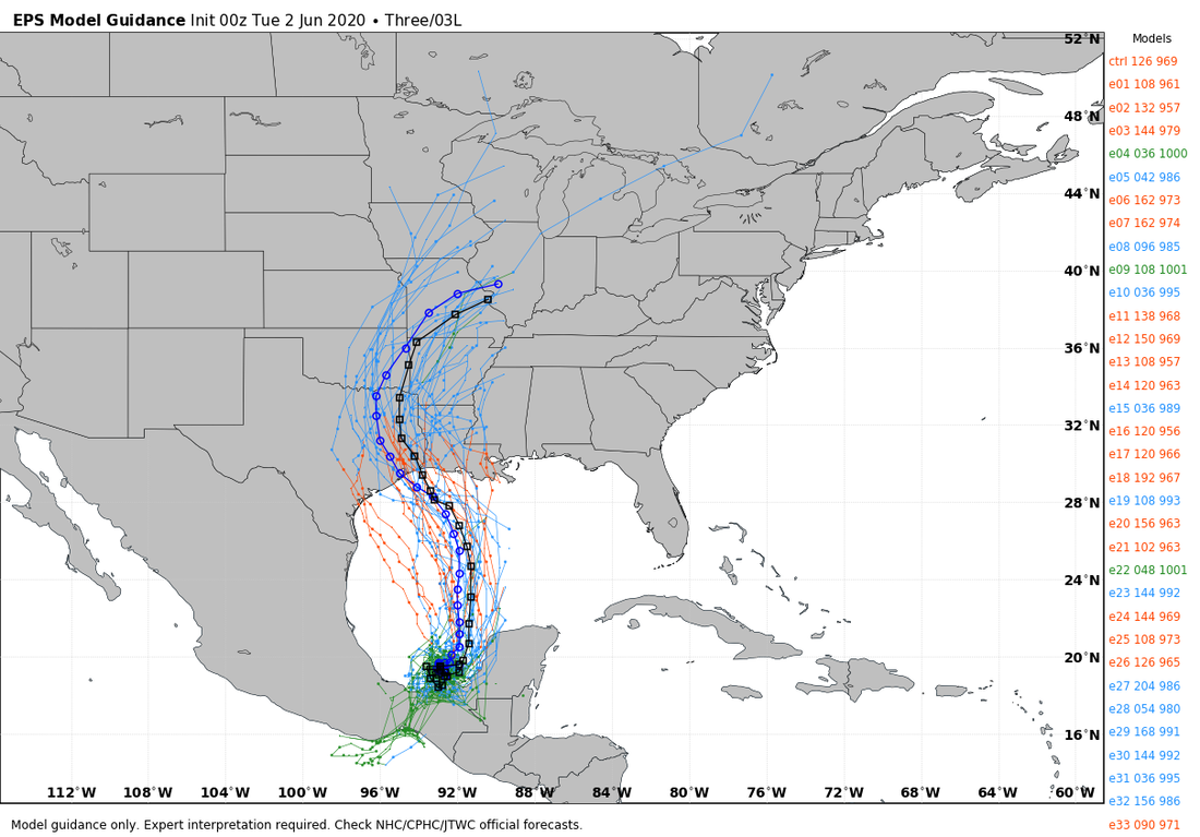 ON THIS DAY IN 1998: A tornado touched down in Frostburg, Maryland on June 2, 1998 at 9:45 PM. This was a part of a killer tornado outbreak of tornadoes that moved southeast from Pennsylvania. The storm first entered Garrett county, impacting the town of Finzel. From there, it moved up and over Big Savage Mountain in Allegany county and ripped through the northern portion of Frostburg, where it reached peak intensity as it crossed the ridge. Winds were estimated between 210 and 250 mph (which was considered F4 criteria on the Fujita Tornado Damage Scale). This was the first tornado to be officially rated an "F4" in the State of Maryland.
Look for the next blog update by noon tomorrow. Enjoy the day! Donovan Neal Owner/Founder - ApexStorm AVERAGE AFTERNOON: On a Monday afternoon in June, temperatures are mostly where they should be for this time of the year. Here are some readings at around 3PM... SHRMAN/DENISON 84 GAINESVILLE 82 BOWIE 84 BRIDGEPORT 81 DECATUR 81 DENTON 85 MCKINNEY 85 BONHAM 84 GREENVILLE 86 ROCKWALL 84 TERRELL 84 WAXAHACHIE 86 CLEBURNE 84 GRANBURY 85 Some active scattered thunderstorms are ongoing in west-central Texas, and should continue to stay to the south of the metroplex, before dissipating tonight. Tonight will be mostly fair for much of the region.  We will mention the risk of isolated showers tomorrow afternoon, but most of the region should stay dry with a partly sunny sky. Temperatures will reach the upper 80s once again. REST OF THE WEEK: Not much change. As the ridge becomes more established, temperatures will continue to increase with time. There still exists the chance of an isolated shower or storm during the afternoon and evening hours, mostly between 12:00 and 9:00 PM. Highs will be in the upper 80s to low 90s with a mix of sun and clouds daily, turning mostly sunny on Wednesday and Friday. THE WEEKEND: We will continue to roll with a persistent forecast; mostly sunny days, highs in the mid to upper 90s with the chance of a random pop-up storm during the peak of daytime heating. Very typical summertime weather for North Texas. NEXT WEEK: Our weather for next week will be largely dependent on now Tropical Depression Three, located over the Southwestern Gulf of Mexico. Global ensemble models have entertained the idea of a landfall in or around the Texas coast, with possible travel further to the north. If this happens, of course, that would mean an uptick of the coverage of showers and thunderstorms during the beginning of the week. However, there is also the chance this stays well to the east, which will leave us with a dry forecast, as convection from a tropical storm usually takes places to the north and east of the circulation center. For now, we will include a small chance of rain everyday for the beginning of next week with highs in the mid 80s. 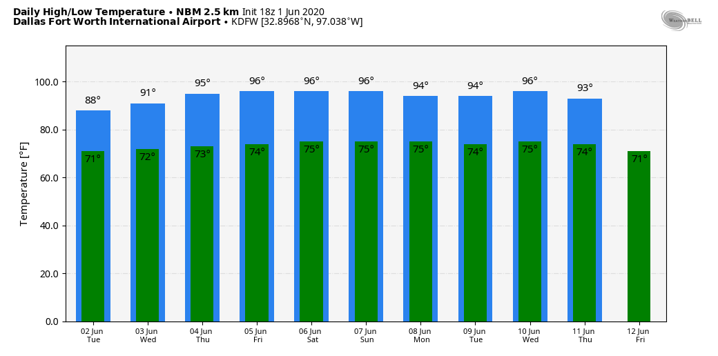 2020 ATLANTIC HURRICANE SEASON: The first day of the 2020 Atlantic Hurricane Season is today, which will run until November 30th. Long-term averages for the number of named storms, hurricanes, and major hurricanes are 12, 6, and 3, respectively. The 2020 Atlantic Hurricane Season names are Cristobal, Dolly, Edouard, Fay, Gonzalo, Hanna, Isaias, Josephine, Kyle, Laura, Marco, Nana, Omar, Paulette, Rene, Sally, Teddy, Vicky, and Wilfred. TROPICAL DEPRESSION THREE: At 4PM today, the NHC posted their first advisory for Tropical Depression Three. Satellite imagery and radar observations from Mexico indicate that the are of disturbed weather centered near the west coast of the Yucatan Peninsula is gradually becoming better organized. This depression will move west-northwestward over the Bay of Campeche, and a tropical storm is likely to form tonight or Tuesday. The system is then forecast to drift westward or west-southwestward over the southern Bay of Campeche through the middle of the week. Persons in and along the coast of the Bay of Campeche should monitor the progress of this disturbance, as tropical storm warnings have already been issued for a portion of this area. 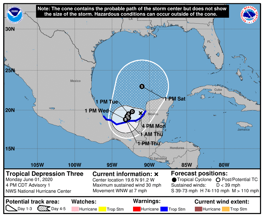 Once this becomes a tropical storm, the name will be "Cristobal", and long-range ensemble data indicates the highest impact potential to be over the Texas or Louisiana coast in about a week. Until this system gets more organized and we get better analysis from hurricane hunter aircraft, there is no way of knowing exactly the final landfall mark, or the peak intensity. 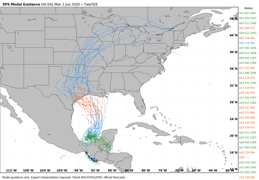 Look for the next blog update on here by noon tomorrow...
Donovan Neal Owner/Founder - ApexStorm |
Archives
April 2024
Categories |
 RSS Feed