|
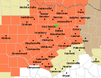
HUMID MORNING: With the absence of wind from yesterday, it is a very muggy late June morning across North Texas with dewpoints in the mid 70s to mid 80s range. We note some showers out in Central Texas, but we might see a random afternoon storm or two as the air continues to heat and become unstable. I expect a high in the mid 90s range across the area this afternoon with heat indices well in the triple digits. The average high for DFW on June 30 is 94°. REST OF THE WEEK: Not much change for the rest of the work week. Partly to mostly sunny skies with highs in the upper 90s. Heat indices will once again be well in the triple digits. As such, a Heat Advisory is in effect for much of the North Texas region until at least Wednesday. Keep in mind that this can be extended for a couple more days if need be. FOURTH OF JULY WEEKEND: High PWAT (precipitable water) values will cover much of North and Central Texas on Saturday, so we will mention mostly cloudy skies with the chance of isolated to scattered afternoon and evening showers and storms. Most of them (not all) will come from around noon to 9:00 PM, and the odds of any one spot getting wet is about one in five right now. There is no way of knowing in advance where and when they form. You just have to watch the radar, especially if you have outdoor festivities planned. Remember, when thunder roars, go indoors. We have had one lightning fatality so far this year, and that is one too many. Highs will be in the mid 90s for the weekend.
NEXT WEEK: We will continue to roll with a persistent forecast of a mostly to partly sunny sky with highs in the mid 90s and very hot heat indices. TROPICS: A trough of low pressure is located off the coast of North Carolina. Significant development of this system is not anticipated while it moves generally northeastward, away from the east coast of the United States and merges with a frontal boundary. The rest of the Atlantic basin is very quiet. ON THIS DAY IN 1912: An estimated F4 tornado ripped through Regina, Saskatchewan, Canada on this day. The storm became the deadliest tornado in Canada’s history as it killed 28 people along a rare, 18.5-mile track from south to north. Look for the next weather discussion and blog update at around noon tomorrow... Enjoy the rest of the day! Donovan Neal Owner - ApexStorm |
Archives
March 2023
Categories |


 RSS Feed
