
|
SUMMERTIME WEATHER: The weather pattern looks typical for late June/early July here in North Texas this week. The main jet stream remains well to the north of the state, and we are in a very humid airmass. Each day this week, we expect a partly to mostly sunny sky, and, as the summer heat and humidity develops today and Tuesday, the air becomes buoyant, thus, opening the door for showers and thunderstorms to develop. In these zones, these showers and storms tend to have a random nature to them in the summer time, and most of them form between the hours of 12:00 PM through 9:00 PM. The odds of any one spot getting wet today and tomorrow is about one in ten, and the heavier storms may be strong to severe with damaging winds and hail. 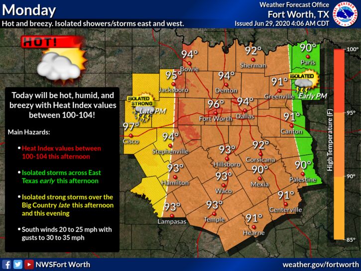 Hour by hour changes in the placement of showers and storms are determined by small scale weather features that are impossible to pinpoint well in advance. Otherwise, temperatures will be at around seasonal averages this week, around the mid 90s with the heat indices well in the triple digits.
HOLIDAY WEEKEND: Not much change. Look for partly sunny hot, humid days with highs in the mid 90s with heat indices in the triple digits. Chance of an isolated storm on Saturday. NEXT WEEK: Annnddddd, the same pattern rolls along. The same forecast ensues with hot, muggy days with highs in the low to mid 90s with heat indices in the triple digits. TROPICS: Shower and thunderstorm activity associated with a tropical wave located over the central tropical Atlantic has increased during the past few hours. Some slight development of the wave is possible during the next day or so while it moves westward to west-northwestward at around 20 mph. Strong upper-level winds are forecast to inhibit further development by mid-week. And, an area of low pressure is forecast to form off of the southeastern coast of the United States on Tuesday. Some development of this system could then occur later this week as it moves generally northeastward well offshore of the east coast of the United States. The rest of the Atlantic basin is quiet. ON THIS DAY IN 1998: “The Corn Belt Derecho of 1998” in the following states NE, IA, IL, IN, KY. A derecho which originated in far southeast South Dakota moved across Illinois during the afternoon and evening and continued as far east as Ohio the next morning. Every county in central Illinois sustained some damage, as these severe thunderstorms passed. Winds gusted in the 60 to 80 mph range, with some localized microbursts producing winds more than 100 mph. Significant damage occurred in the microburst areas, including the towns of Morton, McLean, LeRoy, and Tolono. In Tolono, 22 cars of a southbound 101-car Illinois Central freight train were blown off the tracks. It was unknown how many vehicles were picked up by the wind, but 16 cars were turned over, and another six derailed but remained upright. The train was en route to Centralia from Chicago with a load of mixed freight, including plastic pellets and meal. The freight cars empty weighed about 60,000 pounds, while a full one weighs about 260,000 pounds. Overall, 12 people were injured, and damage was estimated at around $16 million. Look for the next blog update at around noon tomorrow... Enjoy the day! Donovan Neal Owner - ApexStorm |
Archives
March 2023
Categories |
 RSS Feed
