
|
AVERAGE AFTERNOON: On a Monday afternoon in June, temperatures are mostly where they should be for this time of the year. Here are some readings at around 3PM... SHRMAN/DENISON 84 GAINESVILLE 82 BOWIE 84 BRIDGEPORT 81 DECATUR 81 DENTON 85 MCKINNEY 85 BONHAM 84 GREENVILLE 86 ROCKWALL 84 TERRELL 84 WAXAHACHIE 86 CLEBURNE 84 GRANBURY 85 Some active scattered thunderstorms are ongoing in west-central Texas, and should continue to stay to the south of the metroplex, before dissipating tonight. Tonight will be mostly fair for much of the region. 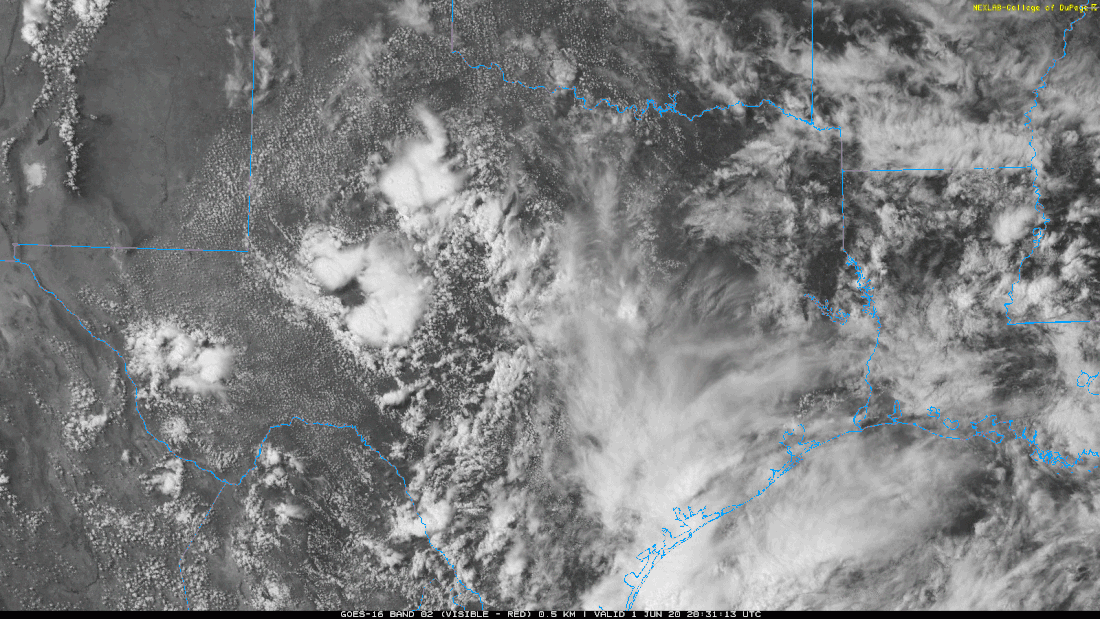 We will mention the risk of isolated showers tomorrow afternoon, but most of the region should stay dry with a partly sunny sky. Temperatures will reach the upper 80s once again. REST OF THE WEEK: Not much change. As the ridge becomes more established, temperatures will continue to increase with time. There still exists the chance of an isolated shower or storm during the afternoon and evening hours, mostly between 12:00 and 9:00 PM. Highs will be in the upper 80s to low 90s with a mix of sun and clouds daily, turning mostly sunny on Wednesday and Friday. THE WEEKEND: We will continue to roll with a persistent forecast; mostly sunny days, highs in the mid to upper 90s with the chance of a random pop-up storm during the peak of daytime heating. Very typical summertime weather for North Texas. NEXT WEEK: Our weather for next week will be largely dependent on now Tropical Depression Three, located over the Southwestern Gulf of Mexico. Global ensemble models have entertained the idea of a landfall in or around the Texas coast, with possible travel further to the north. If this happens, of course, that would mean an uptick of the coverage of showers and thunderstorms during the beginning of the week. However, there is also the chance this stays well to the east, which will leave us with a dry forecast, as convection from a tropical storm usually takes places to the north and east of the circulation center. For now, we will include a small chance of rain everyday for the beginning of next week with highs in the mid 80s. 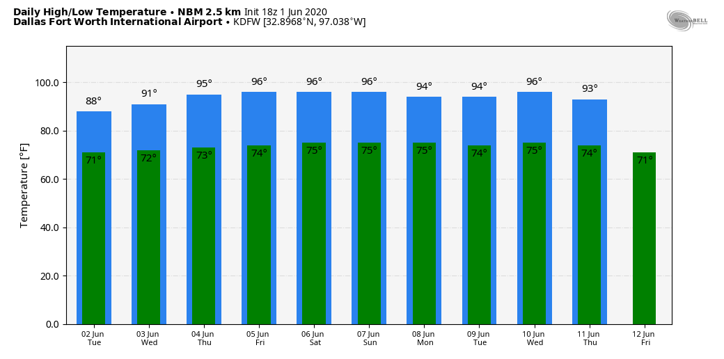 2020 ATLANTIC HURRICANE SEASON: The first day of the 2020 Atlantic Hurricane Season is today, which will run until November 30th. Long-term averages for the number of named storms, hurricanes, and major hurricanes are 12, 6, and 3, respectively. The 2020 Atlantic Hurricane Season names are Cristobal, Dolly, Edouard, Fay, Gonzalo, Hanna, Isaias, Josephine, Kyle, Laura, Marco, Nana, Omar, Paulette, Rene, Sally, Teddy, Vicky, and Wilfred. TROPICAL DEPRESSION THREE: At 4PM today, the NHC posted their first advisory for Tropical Depression Three. Satellite imagery and radar observations from Mexico indicate that the are of disturbed weather centered near the west coast of the Yucatan Peninsula is gradually becoming better organized. This depression will move west-northwestward over the Bay of Campeche, and a tropical storm is likely to form tonight or Tuesday. The system is then forecast to drift westward or west-southwestward over the southern Bay of Campeche through the middle of the week. Persons in and along the coast of the Bay of Campeche should monitor the progress of this disturbance, as tropical storm warnings have already been issued for a portion of this area. 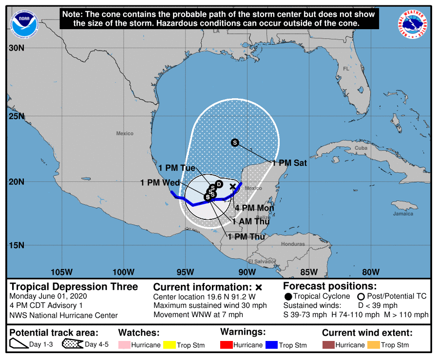 Once this becomes a tropical storm, the name will be "Cristobal", and long-range ensemble data indicates the highest impact potential to be over the Texas or Louisiana coast in about a week. Until this system gets more organized and we get better analysis from hurricane hunter aircraft, there is no way of knowing exactly the final landfall mark, or the peak intensity. 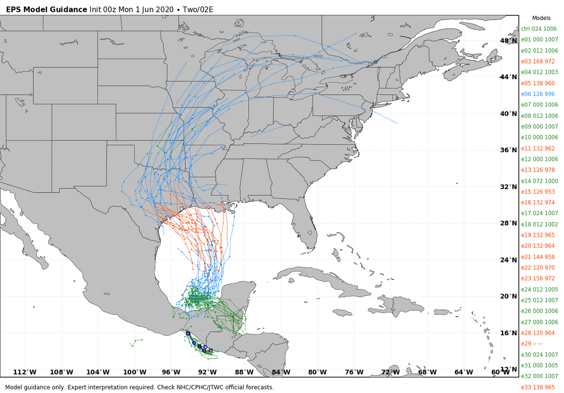 Look for the next blog update on here by noon tomorrow...
Donovan Neal Owner/Founder - ApexStorm |
Archives
March 2023
Categories |
 RSS Feed
