
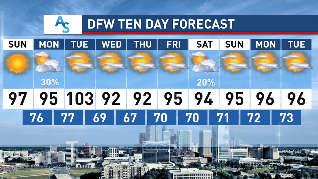
 The past week has shown North Texas plenty of sunshine and heat, with more of that to come in the future. Aside from the few scattered storms last week, it was a mostly dry, hot week with days in the 80s and 90s, and looking forward, summer heat is the new normal for North Texas. What can we expect for the upcoming week?
CRISTOBAL Tropical Storm Cristobal, who is currently residing in the Gulf of Mexico, will be making landfall to our east in Louisiana and making its way up through the United States on Sunday through Tuesday. There is a fairly decent chance that the outer remnants of Cristobal make its way to DFW as a few rain bands rotate around our area as the low pressure system disperses. It’s not a given, as tropical storm paths are still difficult to predict even this close out, but the possibility still exists. Regardless, as a result of Cristobal, a spike in temperature will happen on Tuesday with our first possibility of triple digits this year. Compressional heating as a result of a dry air on the backside of the tropical storm, in a process called “subsidence”, will result in record heat for lots of Texas, and it’s possible we could also set records, depending on the speed of the incoming cold front as well. The cold front will only lower temperatures a little bit but it will drop dew points, making the air less muggy. “DEATH RIDGE” Many of you have heard talk of the so-called “death ridge” that has placed itself over the United States. What does this mean? In its most basic form, troughs are associated with low pressure systems and ridges are associated with high pressure systems. High pressure systems, especially in the summer, can lead to rising temperatures, whereas low pressure systems, commonly associated with cold fronts, cool the air, due to the interaction of the upper and lower dynamics of the atmosphere. The death ridge brings calm winds and strong cap inversions that make all moisture in the area unable to form as rain clouds, creating hotter, more intolerable days. Thankfully, if we have a death ridge, it is quite mild, as temperatures likely won’t break triple digits aside from after the tropical storm. There will also be a number of chances for low pressure systems to come in and potentially give us relief later on the week, though that is less likely at this point in time. For the foreseeable future, DFW will be subject to dry, 90 degree days with plenty of sunshine, for everyone to enjoy whatever pool they can socially distance themselves at. Stay cool, stay hydrated, and stay weather aware! -Colin Welty |
Archives
March 2023
Categories |
 RSS Feed
