
|
Happy Easter, North Texas. He has risen!
Today, while the kiddos are doing any festivities or your family may be heading out to church, it will be mild and humid across the area with plenty of cloud cover in place. A few breaks in the clouds are possible through the day, and as a boundary approaches, we may see isolated sprinkles/showers and possibly a storm or two. No severe weather is anticipated. Coverage will be minimal and favor areas north of I/20. This boundary will stall at the I/20 corridor overnight. This is when the forecast turns difficult. The NAM has much colder air with lows near 37°F, but many other models have us near 50°F. I will favor the warmer solution, but will monitor trends as needed. This will also affect Monday, as some models have us in the 70s with isolated strong storms (one or two severe isn't ruled out, but overall severe risk on Monday is very low) meanwhile a few other models have widespread drizzle/fog/low clouds with highs in the 40s. This will be a close call, and I will favor the warmer solution, but will lower highs to mid 60s to blend solutions together. This is a very hard forecast. Either way, this front will lift north Monday night and will draw in warmer and humid air back into Texas Tuesday morning. As a dryline, cold front, upper level trough, moisture, instability, and shear meets in our area, strong-severe storms are forecast to develop Tuesday afternoon/evening, with the best chance of severe weather east of I/35. Large hail and damaging winds look to be the primary risks, but a few isolated tornadoes aren't ruled out at this time. Cooler air and dry air moves in Wednesday, before warming up Thursday with storm chances returning by Friday associated with our next frontal boundary that may bring some cooler air back into North Texas. Jonathan Williams Weather Forecaster Storm Specialist NWS/NOAA Ambassador After a sunny day today, things shift heading into your Easter Sunday. Widespread low cloud cover will increase across the area overnight with a cloudy sky tomorrow. A few isolated showers may develop along a boundary during the daytime north of DFW. A few sprinkles are possible in DFW, but none of this will be a washout. Any amounts will be well north of our area, and even those will be very very light. A few storms may develop overnight in Oklahoma, as well. We will be in the 80s tomorrow, with some 70s. Cooler air will remain along the Red River.
This boundary will likely lift back north Sunday evening, but if it doesn't, we may turn colder Monday IF the boundary pushes farther south tomorrow evening. I'll keep you updated. (w/ colder solution, highs would be in the mid 50s) Either way, we will be cloudy on Monday with a slight chance of rain with the boundary lifting northward drawing in warm air and moisture Monday night. Temperatures will rise if we have the colder solution Monday night, otherwise they will remain steady near 70°F. Another cold front and dryline will move towards the area Tuesday afternoon and evening. The most likely scenario will be as this boundary moves towards the Red River mid afternoon Tuesday, severe storms will fire up. The will track southeast and affect the metroplex during the evening hours. Significant instability will aid in this severe risk. Medium range models are in general agreement with the timing of a southern-stream trough to move across central/eastern parts of TX/OK by peak heating on Tuesday. A moist, unstable, and strongly sheared warm sector will be conducive for organized severe storms to develop initially in vicinity of a dryline with supercells likely. -Storm Prediction Center (NOAA/NWS) All modes of severe weather are possible indvluding large hail, damaging winds, isolated tornadoes, very heavy rain, pockets of flash flooding, and frequent lightning are possible in these storms. The front clears our area late Tuesday night bringing in subsidence and cooler air, making for a mainly sunny and cool Wednesday with highs in the lower to mid 60s. As another frontal boundary and short waves rotate across the region, more showers and thunderstorms return next weekend, mainly on Friday and Saturday. Severe weather appears unlikely at this time. The best chance of rain will be east of the metroplex. This cold front may bring some relatively cooler air in next Saturday and Sunday with highs possibly into the 50s in the vicinity with lows in the 40s. Any freezes *should* remain well into the Oklahoma/Arkansas area and points north and east. Have a great Saturday and have a Happy Easter! Jonathan Williams Weather Forecaster Storm Specialist Today will be a fantastic day, with highs in the upper 70s to near 80° across the area today under partly cloudy skies. Cumulus fields may develop this afternoon, leading to beautiful mix of sun and clouds today! All of North and Central Texas is forecasted to remain dry during the daylight hours today. A boundary will approach the area late tonight. Let's talk more about this...
As a cold front approaches us, isolated to possibly scattered showers and t-storms will develop. It is uncertain how far south these storms progress at this time. Therefore, will introduce 30% storm chances for the DFW area overnight. Severe weather isn't expected, but a few storms may be strong with dime to nickel size hail and gusty winds. Any storm may produce brief heavy rain and lightning as well. Tomorrow afternoon the boundary will still be draped along the Red River, so our northern tier of counties will be colder with temperatures mainly into the 50s, while we remain into the 70s and 80s. High uncertainties take place into Monday. The frontal boundary is expected to move farther south, but just how far south is uncertain. There are also questions on how far north does it lift back north as low level moisture and several other factors take place. Depending on where this happens, it may either be a warm/humid day with a few storms, or a cold and dreary day (low 50s for highs) with widespread drizzle in the forecast. The GFS keeps us warm, but the NAM keeps us cold and dreary with drizzle. I'm leaning towards the NAM solution due to a more progressive pattern in the upper level flow, but I will keep warmer highs in the forecast. However, I will lower forecast high temperatures to the 70° mark. We will keep you updated on this very tricky forecast. Either way, the front will lift back north Monday night and we will be significantly warmer Tuesday morning. Temperatures (if cold solution verifies) will warm up overnight to the upper 60s, or if the warmer solution verifies, we will remain mainly steady overnight. We will watch as another cold front moves into the region Tuesday afternoon and evening. Scattered to numerous showers and thunderstorms will develop during this time with highs in the upper 70s to lower 80s. As this front moves southeastward, thunderstorms will develop in our western and northwestern counties after 2PM and track towards the metroplex and will arrive early evening. With significant amounts of instability, this will set the stage for strong to severe storms. All modes of severe weather appear possible. Stay tuned on this forecast! We will dry out Wednesday with cooler air, but warm air returns late week with strong storms (severe possible) returning Friday with a potential of a chilly pattern next Friday. Low potential of any freezes or much cold air, but it's there. Have a great Saturday! -Jonathan Williams While we've got some storms in the coming days, (Sunday into next week) we've got something to chat about... and it's likely the most unexpected thing you would hear from me near April... an Arctic blast may be on its way to Texas.
Looking at the operational GFS, European, EPS, and ensembles, there appears to be at least decent agreement of some cold air next weekend. Let's dig in some more. While it's too early to get excited, it's something we have to monitor in the coming days. It looks like a strong cold front will plunge southward bringing in rain chances and storms to the North Texas area early next weekend, but things change quickly. The gefs ensembles have a risk of wintry weather in the southern plains, as well as many other operational models. Indeed, this is one of the strangest things I've seen in my journey of meteorology, but we gotta remember that we are in Texas. Everything happens here. I'll keep you posted. Don't get excited yet, but do stay tuned for forecast updates. Have a blessed night, Jonathan Williams The clouds are clearing across the DFW area, and the sunshine is FINALLY coming out! But, if you thought we were done with the storms, think again!
Isolated thunderstorms are expected to develop this afternoon. Coverage will be less than 25%, but have the rain gear just in case. Rather be safe than sorry!! We will dry out and clear out overnight with some sunshine returning for your Friday. Most people have the day off, and we will have a very pleasant day with highs in the lower 70s. A stray shower or thunderstorm may develop east of our area with any lingering lift or moisture, but DFW will remain dry, and basically all of North Texas should remain dry. Heading into Saturday, an increase of low level moisture ahead of our next boundary with cause for some clouds, especially towards the latter half of the day. As this boundary approaches the metroplex, a few showers and thunderstorms may develop along it. This will mainly occur during the overnight hours, with the highest rain chances north of I/20 and east of I/35. No severe weather is anticipated at this time. By Sunday morning as many of us head to church and the kiddos have their Easter egg hunts, clouds will be in abundance across the area with a small chance of a shower or storm mainly east of DFW. A few isolated showers and possibly a few thunderstorms may develop during the afternoon hours, but I don't see much of a risk for any severe storms. A strong storm with gusty winds and frequent lightning isn't ruled out. By Monday, clouds will be with us once again with scattered showers and thunderstorms expected throughout the day. With CAPE approaching 1000, a few storms may turn strong to severe with hail and gusty winds as the primary risks. Coverage will be near 30%. A few isolated storms are possible Monday night into Tuesday, with a few strong storms possible mainly with a marginally severe hail risk. On Tuesday, isolated rain showers and possibly a thunderstorm will be around during the morning hours. Significant instability is expected by the evening, and a dryline and a cold front will be approaching. Strong to severe storms are expected to develop along these features with all modes of severe weather looking possible, with very large hail being the highest risk. We will remain active mid to late next week with storms appearing likely with a threat of severe storms each day. Looking at the long range guidance, the models have continued to show a chance of a spring Arctic blast near the 8-10th of April. It's WAYYYYYYY to early to know anything else than a general idea. It's possible that we don't see any cold and that we stay warm. Due to at least a low risk of some cold air, I would recommend not planting just yet. If you did, don't worry at this point because this scenario likely won't happen, but it's not ruled out at this time. I'll keep y'all updated on this chance, although I'm quite doubtful in this cold solution. Have a great day and God bless! -Jonathan Williams QUIET, COOL START - The weather is pretty quiet across the region this morning; we are all cloudy and foggy with temperatures in the 50 degree range. We could see a few isolated thunderstorms on the radar, but nothing heavy and widespread and we won't see any issues with severe weather today. Clouds should lighten during the afternoon and evening, setting up for sunny, dry conditions for the Ranger's Opening Day. Highs should be in the low 70s. TOMORROW AND THE WEEKEND - The sky clears out to sunny skies with highs in the low 70s, which will set up for a good Easter weekend. We trend warmer on Saturday with abundant sunshine with highs in the upper 70s, and Sunday will continue to be dry. The sky will be partly cloudy with highs in the low 70s. A few isolated showers are possible with a surface front passing through, but most of the region will continue to remain dry. NEXT WEEK - Model guidance suggests that most people will remain dry next week with highs in the low 70s. Early part of the week will feature mostly cloudy skies, but the sun peaks out during the latter half of the week. See the Texas Weather Discussion Video for more details. 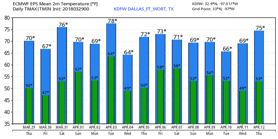 ON THIS DAY IN 2017 - A squall line affected the North Texas area during the pre-dawn hours on March 29th. At least two tornadoes touched down; one to the north of Fort Worth, Keller, and Southlake, and one in Lewisville, which received an EF-1 rating. Elsewhere, mainly people were left without power due to tornado-like wind speeds. The highest wind report during this was 95mph.
Its been a cloudy, cool, and damp day across North Texas. Most areas have seen 3-4" of rain in the past 48 hours! But, if you thought we were done with the rain, think again. 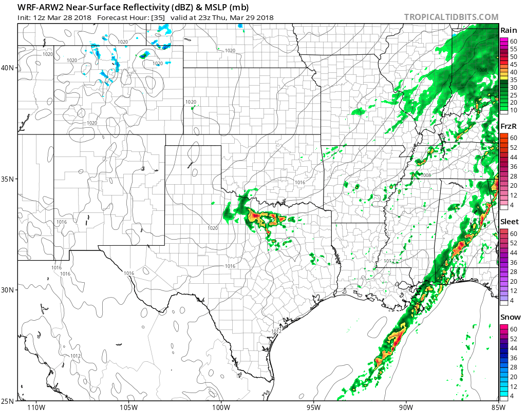 The guidance continues to show a risk of scattered thunderstorms tomorrow afternoon, but no severe weather is anticipated. But, with modest CAPE in the upper levels of the atmosphere, a few storms may turn strong with small hail and strong winds gusts up to 50mph. Heavy rain will be the primary risk, along with some lightning. These storms will exit, and we will turn dry and sunny for Friday/Saturday with highs in the lower to mid 70s. For Easter Sunday, isolated showers are possible during the early morning hours, with a break through most of the day, with a few showers and possibly a thunderstorm in the afternoon. Coverage will be less than 30%, so most areas will stay dry, but some won't. No severe weather is anticipated at this time.
Looking towards next week, we look to stay active with frequent storm chances, and several risks of severe storms. Let's break it all down. MONDAY: Scattered showers and storms will be around through the day, with coverage hanging around 30%. A few storms may turn strong to marginally severe with quarter size hail and strong winds as the primary risks. TUESDAY: This day looks to be more significant in the way of severe weather. A few isolated supercells are possible in the afternoon with all modes of severe storms possible, but a boundary and a dryline will bring a risk of numerous (50%) storms during the evening. CAPE values will approach 3500, so severe weather is likely with all modes of severe storms possible. WEDNESDAY: As the boundary moves away, a few storms could still be possible, but not as widespread. Only 20% coverage is expected, but a chance of rain is still there. A strong to severe storm is still possible. LATE NEXT WEEK: Some more showers and thunderstorms are expected, some widespread is likely. It does appear severe weather will be possible, but it's too early to get any more specific. Have a great evening! -Jonathan Williams Radar Check - Showers and thunderstorms continues to move to the northeast this morning, making for a very wet commute in most places... 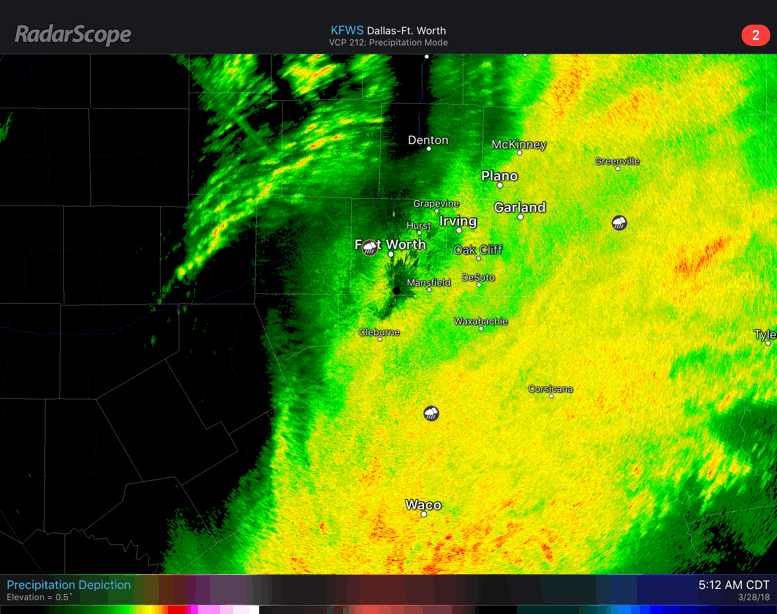 An additional 1/2 to one inch of rain can be expected from this morning activity. While some places in north Texas are under a marginal risk for severe storms, we do not anticipate any big severe weather today. After this morning batch of showers and thunderstorms clear the area, we should be dry during the afternoon and evening with highs in the mid 60s. The sky will be mostly cloudy through most of the day, though some sun could break out in some spots. The upper low pushes off to the east tomorrow, and the sky will feature a mostly sunny sky with afternoon highs in the mid 70s for Ranger's Opening Day. FRIDAY THROUGH THE WEEKEND - Dry air continues to return to the region on Friday, making for mostly sunny skies. Saturday should be a pleasant day with abundant sunshine along with highs in the mid 70s. On Easter Sunday, the sky turns partly cloudy with highs in the low to mid 70s. We will mention the chance of a couple of showers as a weak surface front approaches from the north, but most places stay dry. NEXT WEEK - The first week of April should remain mostly dry with highs in the low 70s. Though we will continue to mention a chance of spotty showers every other day, but will be widespread and most places stay dry. See the Texas Weather Discussion Video for more details. 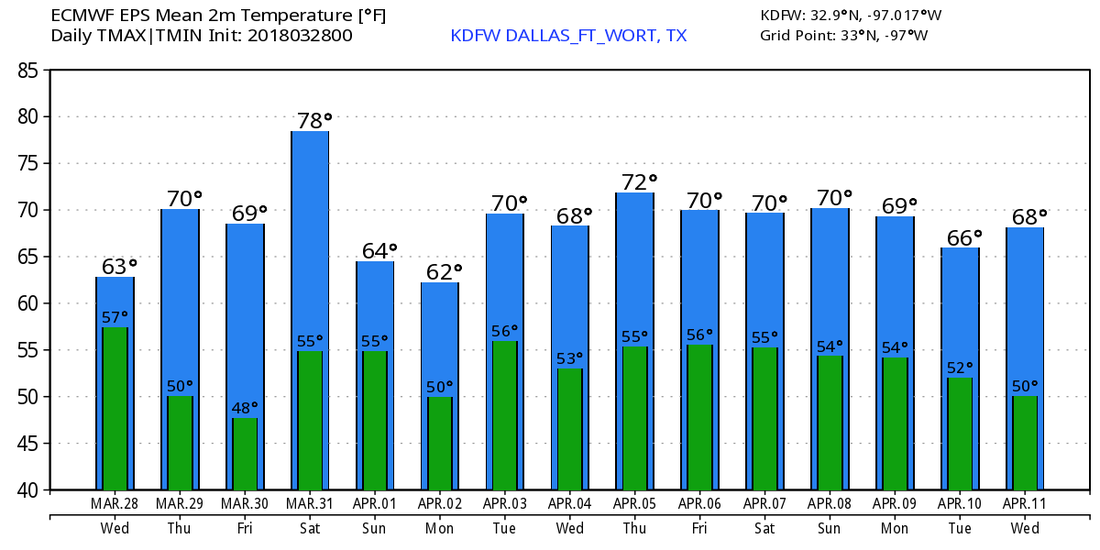 ON THIS DAY IN 2007 - A significant tornado outbreak took place extending from the Texas Panhandle all the way to South Dakota. This was part of a multi-day severe weather event, but this day produced the most tornadoes of the event. A total of 19 tornadoes touched down in Texas alone; Three were rated EF3. This was the second most significant outbreak of 2007.
Radar Check - Heavy rain continues to move to the northeast this morning...  We will see rainfall increase throughout the morning hours, with a new batch of rainfall developing later this morning. Don't be surprised if some of those storms are on the severe side with mainly large hail and damaging winds possible. The tornado potential is very low, but not zero. Timing - By 8AM, we will see discrete thunderstorms attempting to initiate ahead of the main rain mass. Those storms are more likely to produce large hail and damaging winds. These storms will merge with the heavy rain to the west, producing a more linear mode of strong to severe storms. This is when the threat of damaging winds is maximized. We will continue to see strong to severe storms during the afternoon, before tapering off in the evening. The temperature will stay in the low 70s today. Tomorrow - Our last round of showers and thunderstorms will arrive during the pre-dawn hours. We will see rain for most of the morning, then we will clear out to dry conditions during the evening with highs in the mid 60s. The rest of the week will give out to abundant sunshine with highs in the low 70s. The Weekend - Not much change. We will continue to stay sunny with afternoon highs in the mid to upper 70s. No sign of any widespread rain during that time period. Next Week - Despite a few clouds, at least the early part of the week looks dry with afternoon highs in the low 70s. We will continue to forecast cool nights and pleasant days ahead. See the Texas Weather Discussion Video for more details. 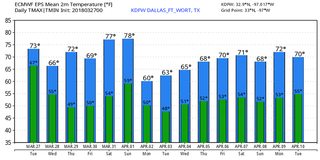 Sub-Mild Morning - That's something we haven't said in quite some time. Temperatures are in the upper 60s, with many places in the 70s this morning, about 18 degrees above the average low for late March. We will continue to remain cloudy, but highs will remain in the low 80s. tl:dr - An active weather pattern will set up through Thursday, with severe weather and heavy rainfall expected during that time. Due to troughing in the southwest, with a slow-moving upper-low, a stalled front at the surface, and ridging to the east of us, moisture will surge in to the big state, which will result in heavy rain and flooding in some spots becoming likely on Tuesday and Wednesday. Today, we will deal with the severe weather threat in West Texas before we get to the heavy rain part. The SPC has defined a risk for severe weather for most of West Texas, with the standard "slight" risk extending from San Angelo all the way to the north of the Oklahoma City metro... 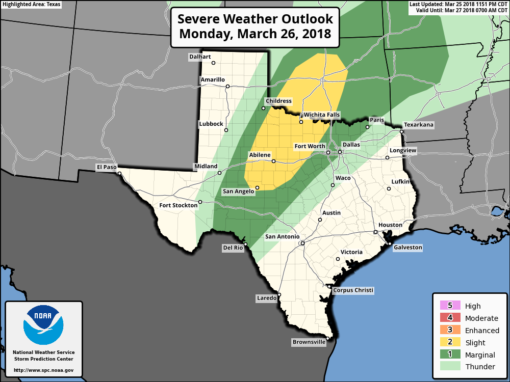 The one thing that we can guarantee is that the storm coverage this week will be much higher than the lone supercell near Wichita Falls yesterday. Multiple rounds of thunderstorms appear likely. Timing - An initial batch of possibly severe storms could develop after 1PM in West Texas. Since these storms may be more discrete in nature, they will be capable of mainly large hail and a couple of tornadoes. Our second round of thunderstorms roll in here after 4PM. Still to the west of the DFW metro, these storms will be capable of mainly large hail and damaging winds, though an isolated tornado cannot be ruled out. During the overnight hours, scattered showers begin to overspread North Texas. From there, we will mention a chance of showers and storms throughout the day on Tuesday. It will not rain all day, but rain will be possible at times. Then, numerous showers and thunderstorms overspread the region during the pre-dawn hours on Wednesday, which will set up for a wet morning commute. From there, we will mention the possibility of scattered showers and thunderstorms at times throughout the day, before all of the activity pushes off to the east. From there, we should be mostly dry and pleasant on Thursday and Friday with highs in the low 70s. Rain amounts will be in the 2-4 inch rain in most spots this week. The Weekend - We will stay dry during the Easter weekend with afternoon highs in the mid to upper 70s with lots of sunshine. Next Week - For the beginning of April, we will stay comfortable and variable with afternoon highs in the low to mid 70s with a mix of sun and clouds. No sign of any significant severe weather for at least the next ten days. See the Texas Weather Discussion Video for more details. 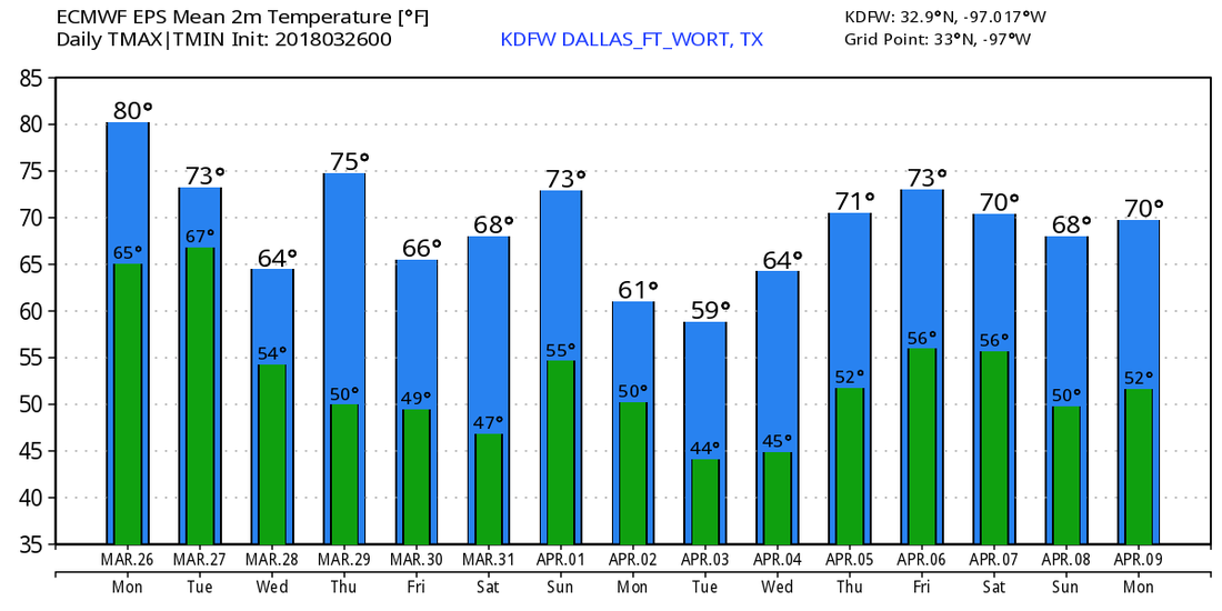 Today has been cloudy, and tomorrow will be much of the same across North Texas.
TOMORROW: Clouds will be with us tomorrow with mostly cloudy to partly sunny skies expected across the area. Our airmass will be very unstable with highs in the upper 80s. We continue to monitor hi-res guidance for any sign of isolated severe storm development tomorrow afternoon. Therefore, we will enter a 10% POP tomorrow afternoon to account for this potential. Any storm will mainly produce a large hail threat. Coverage will be zero to low, but we will monitor the model guidance tomorrow. TOMORROW NIGHT: A warm front will lift north through the region tomorrow night, and isolated storms will develop along it. Any storm that develops may produce strong winds and hail. The highest risk for storms will be north of I/20. SUNDAY: A dryline will move towards our western continues during the afternoon. Scattered thunderstorm development will take place, and any storm may quickly turn severe with large hail, damaging winds, and a few tornadoes. The exact location of the dryline is still unknown, but it appears like it will set up just west of I/35, but storms will track northeast/east into the metroplex during the evening posing a severe risk. NEXT WEEK: Widespread storms return next week, especially Monday through Thursday. Very heavy rain is expected during this timeframe, and a few severe storms will be possible with damaging winds and large hail Monday-Tuesday. 3-6" of rain is expected next week. Have a great evening and stay up to date with the storms this weekend and next week. -Jonathan Williams Comfortable Start - Temperatures are mostly in the low to mid 60s this morning - enough to warrant a light jacket as you head out the door. Don't expect much sun today either, but breezy conditions with highs in the mid 80s seem plausible. A few spotty showers could develop during the afternoon hours, but most places will remain dry. The Weekend - Saturday will be even more mild with afternoon highs in the upper 80s this time. Some places could reach the 90s by the afternoon. We should stay dry with a mix of sun and clouds. Our rain chances begin on Sunday, where isolated thunderstorms become possible during the afternoon. Some of those storms could turn severe, posing the threat for mainly large hail due to steep mid level lapse rates. Highs will be in the mid 80s on Sunday with partly sunny skies. Next Week - Our favorite rain pattern sets up this week; trough in the southwest, ridging in the east, open passage for moisture to surge in from the Pacific and the Gulf. We will have the chance of scattered to numerous showers and thunderstorms through Thursday, then we trend dry and sunny on Friday. Throughout the week, we will deal with multiple risks of severe weather on different days. Highs should be in the low to mid 70s for most of the week. See the Texas Weather Discussion Video for more details.  Cool Morning - Temperatures are generally in the 50s with light and variable winds this morning, enough for a light jacket as you head out the door. We project a high of just at or above 80 degrees this afternoon with a full supply of sunshine. Tonight will be warmer, with many places only falling to the low to mid 60s. Tomorrow and the Weekend - Tomorrow will be mostly dry, though we could mention the chance of a few spotty showers during the afternoon hours, but most places will stay dry. With a mix of sun and clouds, highs should be in the mid 80s. Then on Sunday, we turn dry with partly cloudy skies. Highs should be in the mid 80s. A surface boundary will stall somewhere along the Red River vicinity on Sunday, and we will need mention the chance of showers and thunderstorms during the evening. Based on instability values, severe weather appears possible, with large hail the prominent threat due to steep mid-level lapse rates. Keep in mind that it won't be a washout this weekend, and our greater chances of rain comes next week. Highs should be in the mid 80s on Sunday. Next Week - Our unsettled weather pattern begins next week, and we will mention a chance of showers and thunderstorms everyday through Thursday. We do note that the SPC introduces a risk of severe weather from around Del Rio, Texas to Hennessey, Oklahoma. 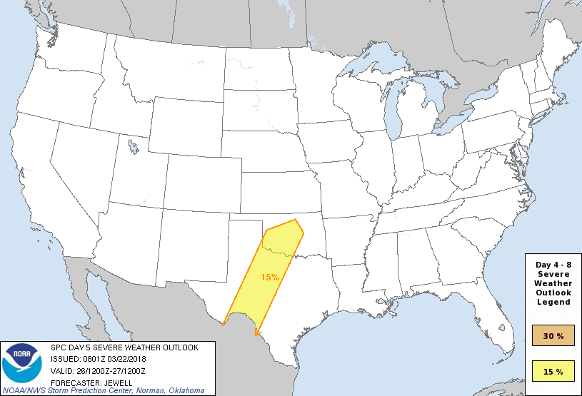 Our upper pattern will feature a trough in the southwest and ridging in the Gulf. This will set the stage for moisture to surge in from the Gulf and Pacific, and we will need to mention the chance of scattered to numerous showers and storms, especially towards the latter half of the week. We will fall to low to mid 70s for most of the week, and will overall look wet and muggy. See the Texas Weather Discussion Video for more details. 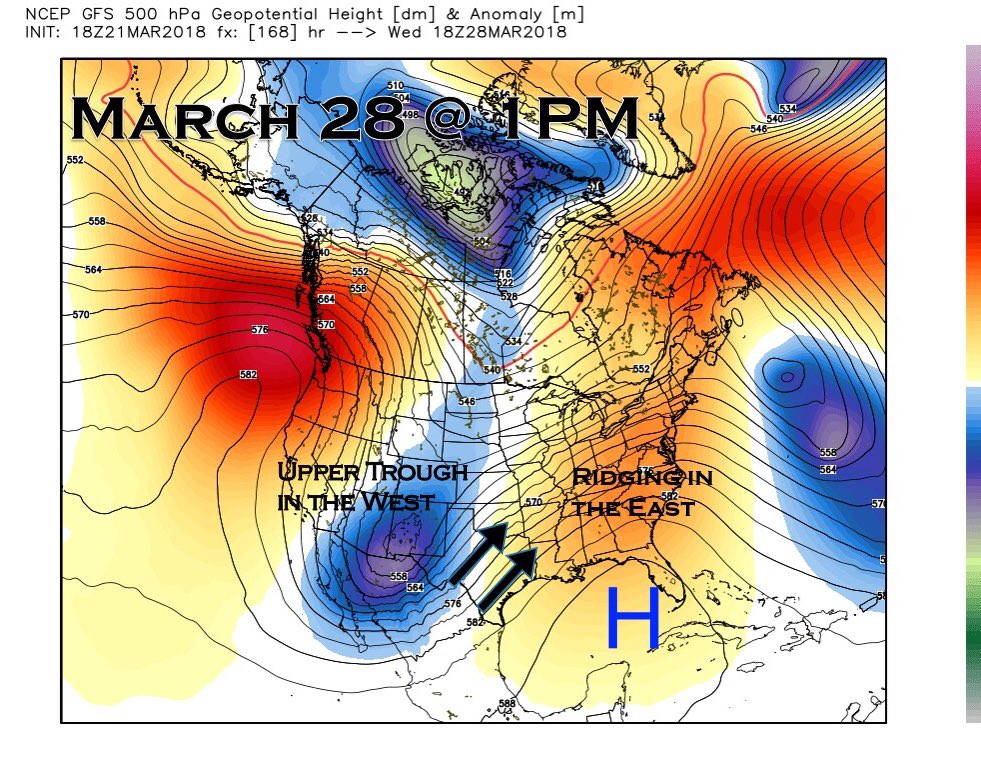 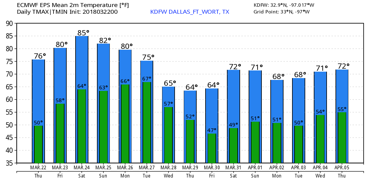 Even Chillier Start - If we take a look at our upper air pattern, the trough to the northeast that is associated with the Nor'easter along the Northeastern Coast is actually helping to pull some cooler air into the south. Temperature range from 34 in Glen Rose to 50 in Dallas Love Field. After the morning, we should turn pleasant and breezy with afternoon highs in the mid 70s. Tomorrow & Friday - Not much change. We continue to forecast chilly nights and pleasant days this week. Both days should be filled with plenty of sunshine with highs in the low to mid 80s. A few spotty showers could develop during the afternoon, but most places will stay dry. The Weekend - Saturday will be very dry and mild with highs in the mid 80s. Our unsettled weather pattern begins on Sunday. In the upper air flow, a likely Polar Vortex splits in western Canada, then begins to track to the south and east. This will set up a southwest flow aloft, similar to what we saw that caused excessive rainfall in mid February. We will deal with scattered showers and storms through the afternoon, some could turn strong to marginally severe. Highs will still be in the low to mid 80s. Next Week - Our unsettled weather pattern continues; Trough in the southwest, ridging in the east. For now the upper air pattern will continue to favor scattered to numerous showers and storms throughout the week, finally ending on Friday. Highs should be in the mid to upper 70s during the early half, falling to the upper 60s during the latter half of the week. See the Texas Weather Discussion Video for more details. 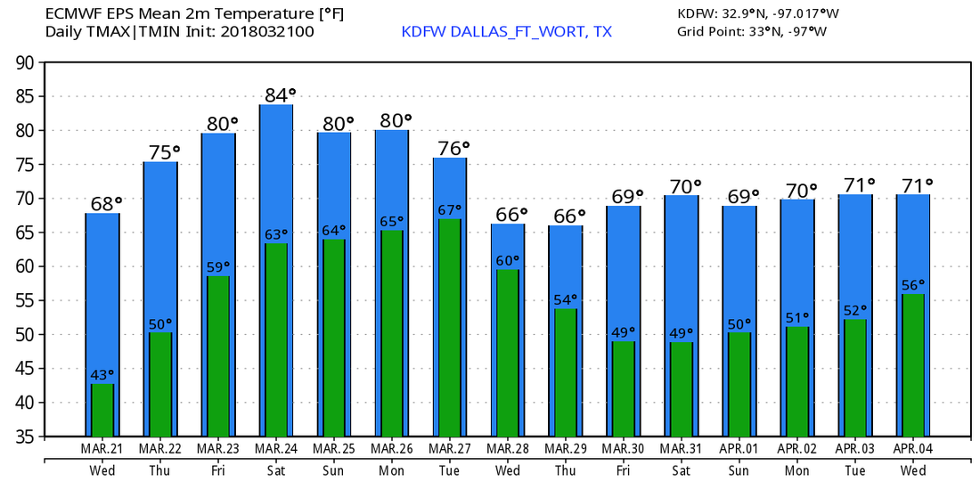 Chilly Start - Temperatures are in the mid to upper 40s for most of the north Texas region this morning; a typical mid march morning. Today will be cool and breezy today as astrological spring officially begins at 11:20 PM today. Today's high will be in the mid 60s. Wednesday Through Friday - With abundant sunshine, we begin a warming trend with afternoon highs in the mid 70s on Wednesday, near 80 degrees on Thursday, and low to mid 80s on Friday. We will start each day in the 52-64 degree range. The Weekend - An unsettled weather pattern begins this weekend. A surface low forms somewhere in the Panhandle on Saturday, which will set off a few showers and isolated thunderstorms during the afternoon hours. A greater rain threat will begin on Sunday, where chances are much higher. Rain will linger into the early part of next week, and rain amounts will be above the 1/2 inch range. Highs will be in the low to mid 80s. Next Week - Our pattern remains somewhat unsettled for at least the early part of next week with a chance of isolated showers and storms each day, then we run dry for the latter half of the week. Highs will be in the low to mid 70s, just about average for this time of the year. See the Texas Weather Discussion Video for more details. 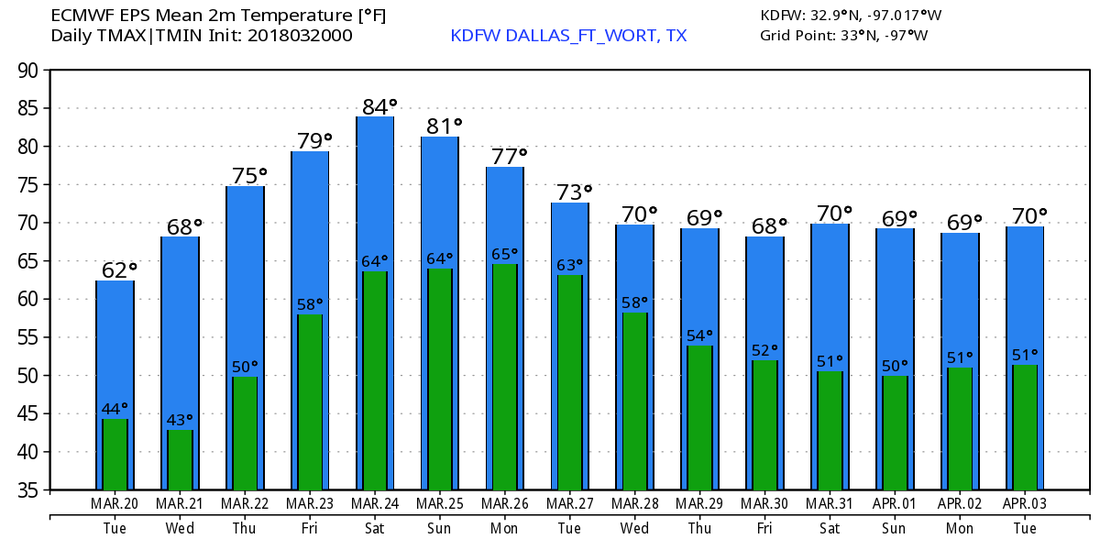 *No Texas Weather Discussion Video this morning* Cool Start - As Spring Break officially ends (crying), we start the workweek with a fair sky with temperatures mostly in the low to mid 60s this morning. Some in the mid 50s outside of the metroplex. A cool start will give off to a pleasant day ahead with highs in the mid 70s with sunshine in full force. A trailing cold front coming from the surface low in Arkansas comes through during the late evening hours, which will keep us in the mid 60s on Tuesday due to cold air advection. We will start the day in the mid 40s. Midweek - Not much change. We will start a warming trend through the weekend, with sunshine still in full force. Afternoon highs will be in the mid to upper 70s on Wednesday and Thursday, and highs will warm to the mid 80s on Friday, setting up for a pretty mild weekend. We will start each day in the low 60s through the weekend. The Weekend - Not much noticeable change. Saturday will be dry with a mix of sun and clouds. Afternoon highs will be in the mid 80s. We start the day in the low 60s. On Sunday, a triple-point setup in West Texas may cause a few thunderstorms to erupt Sunday afternoon. Obviously too early to specifically forecast the potential for severe weather, but we will have to see what comes. Highs will be in the low 80s with lows in the low 60s. Next Week - We continue to forecast the potential for scattered showers and storms for at least the early part of next week, with chances increasing by midweek. We stay in the low to mid 70s for at least the early part of next week. 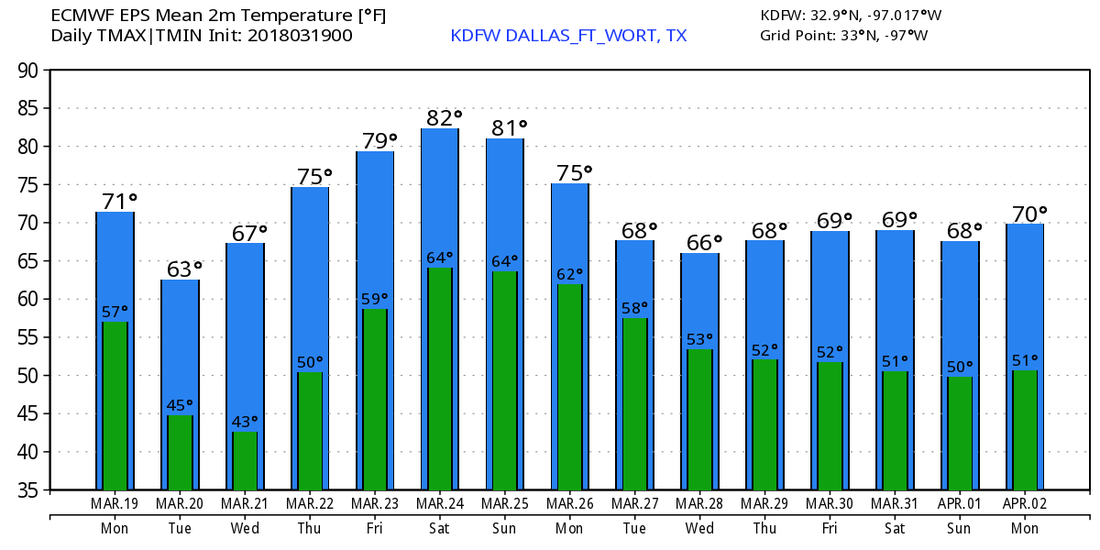 I do want to note that there is potential for some significant severe weather to take place in Dixie Alley today. All modes of severe weather appears possible, including the potential for very large hail, gusty winds, and a few tornadoes, some of which could be strong. Be sure that you stay weather aware if you live in any of the severe weather risk areas. 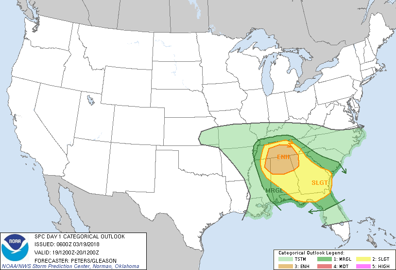 TONIGHT AND TOMORROW: A weak boundary will work in and kick off isolated rain northeast of DFW. Highs reach the mid 80s tomorrow.
SATURDAY: This is a concerning day. A warm front lifts through the region and a dryline moves in leading to storms development. Any storm that develop will pose a risk for very large hail and damaging winds and possibly a few tornadoes. SUNDAY: A dryline moves in during the afternoon and numerous storms develop. Storms may produce very heavy rain, very large hail, damaging winds, and a few tornadoes. Highest chance for tornadoes is east of I/35. NEXT WEEK: Looks mainly dry and seasonable, with lows in the 40s & 50s with highs in the 60s and 70s. A more detailed blog along with maps for the weekend severe risk will come out this evening. -Jonathan Williams Blue Sky - With lots of sunshine in North Texas, temperatures are in the 60s, which is about 2 to three degrees below normal high temperatures for mid march. The rest of the day will be in the mid 60s. Tonight will be clear and cool as we will only reach the low 50s during the overnight hours. Warming Trend - A warming trend begins tomorrow, which we expect highs to be in the mid 70s, with even higher temperatures on Friday with highs in the mid 80s in most spots. Lows will stay in the low 60s Friday morning. I do think the majority of Friday will be dry, however, we still could see a couple of showers on the radar as a surface front approaches from the northwest and a surface low forms to the north. There is a marginal risk for severe storms defined for the eastern 1/3rd of East Texas for Friday. The Weekend - Confidence in the storm situation for the weekend is increasing as model runs are more consistent. Saturday morning will be mostly dry, but the afternoon will bring the possibility of scattered showers and thunderstorms to the region as a surface front stalls somewhere in North Texas. More rain will become possible Sunday afternoon as well, with thunderstorms fewer in number. Severe weather is currently not expected, but a few strong thunderstorms will be possible, and rain amounts should stay below a quarter of an inch for North Texas. For now, both days look mostly cloudy with highs in the low 80s. Next Week - For now, most of next week looks dry and mild with highs in the mid 70s for most days with a mix of sun and clouds. No signs of any severe weather issues at this present time. See the Texas Weather Discussion Video for more details. 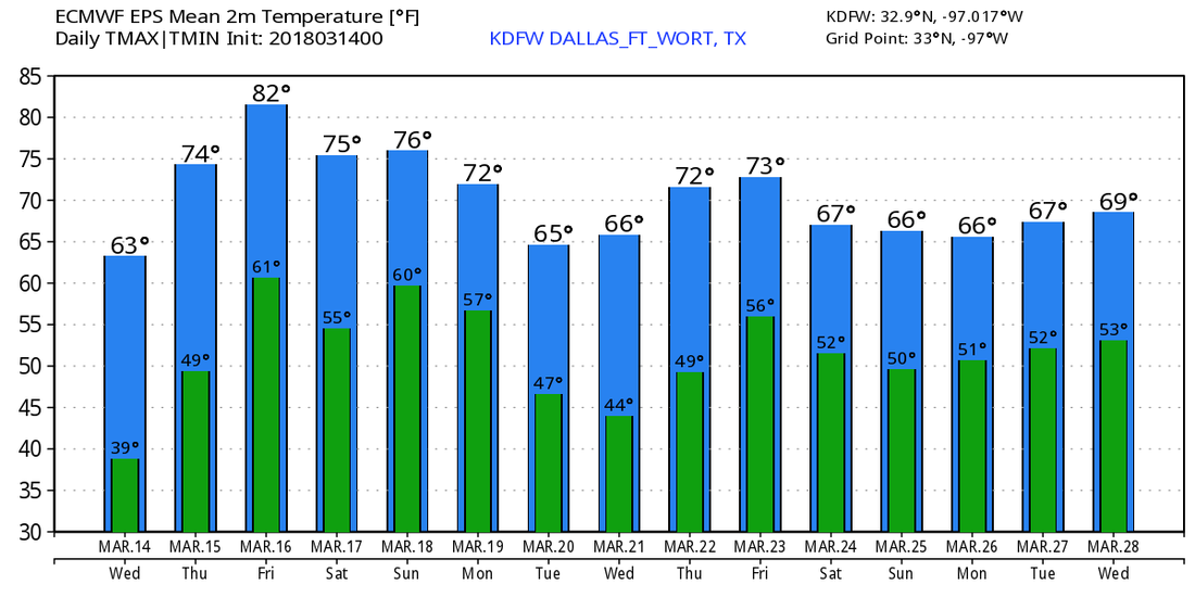 Pleasant March Day - As anticipated, we are under very comfortable and pleasant conditions across North Texas this afternoon with temperatures in the upper 50s/low 60s. We should be fair tonight, with overnight lows in the upper 30s. We won't see any noticeable difference in the weather tomorrow, but highs should warm just a tad to the mid 60s. Mid-Week - Not much change. Dry weather will continue through the week with pleasant days and cool nights. The high Wednesday should be in the mid 60s, then begin a warming trend on Thursday, in which we end up in the upper 70s Thursday afternoon. Friday and the Weekend - Moisture will start to return during the day on Friday, and we will mention the chance of a few showers during the evening hours. The day will be particularly mild with highs in the low 80s. For the weekend, expect generally stable conditions with a mix of sun and clouds with the threat for isolated showers and thunderstorms. If instability arises, be prepared for a couple of storms that could turn strong to marginally severe Saturday afternoon and evening. Then rain will linger into the morning hours on Sunday. This will not be a widespread rain event, but be ready for occasional downpours. For now, organized severe weather is not expected, and rain amounts will stay under a quarter of an inch for North Texas. It is a little too early to specifically pinpoint start/stop times of the rain, but be prepared for showers and storms Saturday afternoon through Sunday morning. The weekend will be very mild with highs in the low to mid 80s. Next Week - We turn sunny and pleasant for at least the early part of next week. We stay dry and mild with highs mostly in the mid 70s. See the Texas Weather Discussion Video for more details. 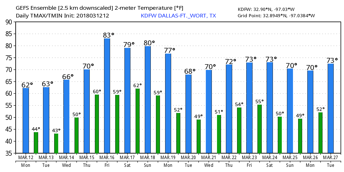 Its been a nice day but as I predicted, the clouds came rolling in near 3-4PM. I don't expect any rain for the overnight hours, although eastern counties may see some sprinkles. Yes, the ground may (in some areas) look wet due to GROUND SWEAT. Yes, it is a thing. Whenever the ground temperatures are cooler than the temperatures just at the surface, condensation takes place and causes it to become wet. Explanation: It's just like a hot waffle on a plate. Notice how the plate gets wet and causes the bottom of the waffle to get soggy? It's because the plate was cooler than the waffle, so the condensation takes place. I hope that clarifies it for you! Anyways, we will wake up tomorrow cloudy and dry, but very humid and warm. Temperatures will be in the 60s across the area. Again, some spotty showers are possible well east of DFW. We will remain cloudy and warm through the day with highs reaching the mid 70s to near 80° across the region. The NAM has us in the lower 70s and it is indeed the best model, but it's really the only model with that solution, but we will see what plays out! Areas west/southwest of DFW may seen a little sunshine with highs soaring to the upper 80s where sunshine comes out! Even parts of the Austin metroplex (mainly western areas) towards the Llano area and the Hill Country may reach the 90s! But DFW I think will remain in the mid to upper 70s to near 80°F. In our eastern counties, a few isolated storms may develop. I don't have any rain in the forecast for the DFW area. Some more storms will develop in our southeastern counties during the evening and overnight hours. Some severe weather is possible east and southeast of DFW. The latest GFS has a few scattered storms developing over DFW late tomorrow night into Sunday morning, and the NAM 3k has it too, so I will have a 20% chance of storms tomorrow night and Sunday morning, but I suspect most areas will remain dry. No severe weather is expected. Sunday will be cloudy and significantly colder with highs in the mid to upper 50s with a brisk north wind making it feel like the lower 50s and some upper 40s.
NEXT WEEK: It will be dry and sunny each day with highs in the 50s and lows near freezing Monday, near 60°F on Tuesday with lows in the upper 30s, near 64°F on Wednesday with lows in the lower 40s, near 70° Thursday with lows in the lower 50s. Clouds return on Friday ahead of our next rain maker. NEXT WEEKEND: Showers and thunderstorms will likely be widespread next Saturday, and there does appear to be a low end severe risk. We will dry out next Sunday with highs in the 70s both days. There are signs of strong storms heading into next Monday and Tuesday. COLD AIR RETURNING?? A few models of the longer range guidance have some much colder air returning late in the month. Winter weather chances look to be scarce. I do think we are done with ice and snow, but I can't rule it out at this time. For all gardeners, I would hold off on the planting, especially if your are planting plants that are sensitive to temperatures near freezing. This is no promise, but something to monitor for sure. Low risk of any freezes the rest of the year but a few cannot be ruled out. Have a fantastic evening and give glory to God for this nice warm weekend this weekend! -Jonathan Williams. Follow on twitter @apexwxdfw for frequent updates and weather maps and the forecast! Jacket Weather This Morning - Although not as cold as recent days this week, temperatures this morning are still in the low 50s/upper 40s. A south wind of 10-15 mph will make it feel even cooler this morning. Today will feature mostly cloudy skies with breezy conditions and a high in the mid 70s. The Weekend - We turn very mild on Saturday with afternoon highs in the low 80s and lows in the mid 60s, still under mostly cloudy skies. Any rain that we see will be in the form of a stray shower or thunderstorm, and no rainfall is expected in North Texas. Some places in the eastern corner of Texas could see a few severe storms, where the SPC has defined a marginal risk for severe storms tomorrow.  A cold front comes through Saturday evening, which will leave us cooler on Sunday with highs only reaching the low 60s. Lows will be in the low 50s with a mostly cloudy sky. Next Week - Not much change. We stay dry for much of next week with highs in the low to mid 60s with a mix of sun and clouds. We warm up during the latter half of the week, and some places could touch 80 again by next weekend. See the Texas Weather Discussion Video for more details.   HERES YOUR APEXWX 7-Day forecast!Hey North Texas! Today was partly sunny with highs in the mid to upper 60s, but tomorrow will have some morning sunshine, but clouds quickly roll in near midday. No rain is expected, but drizzle cannot be ruled out east of I/35. We will warm to the lower to mid 70s across the region, with some upper 70s likely west of the DFW metro. We will only fall to the lower to mid 60s tomorrow night, but Saturday's high temperatures are tricky. A few models have us near 80° but some have us in the lower 70s, and the NAM, which is very accurate, has us in the upper 60s. I did lower my high temperatures to the mid 70s and will monitor forecast trends and make changes as needed. Some isolated storms may pop up east of Dallas during the afternoon, but a few models have a few storms developing in DFW along the cold front during the evening hours on Saturday. The instability will be meager during the evening, so I don't have any severe weather in my forecast at this time. If models increase CAPE values, we may have a severe risk, but all storms will remain isolated to scattered and far between. (Also known as widely scattered (spaced) thunderstorms) We will turn significant colder on Saturday, and even a few models have us falling during the day. I may have to lower highs as needed. Either way, a brisk north wind and very limited sunshine will aid for a cold day across the area. Southeastern counties may reach the upper 50s and lower 60s, but DFW will be colder, with highs in the lower to mid 50s. A few northern areas may be stuck in the 40s. We will clear out Sunday night and we will wake up Monday morning with near freezing temperatures, with 20s possible along the Red River. We will only reach the mid 50s Monday afternoon. Some more mild but very pleasant air will return later in the week with sunshine continuing to be the trend through the week.
There are signs of widespread thunderstorms returning to the area next weekend, and severe weather does appear possible during this timeframe. There are also signs of much colder air heading into the late part of March. Stay tuned for that... but icy weather or snow seems unlikely, but you can't really tell this far out. ;) (and yes, snow and ice can occur in late March, as we all remember some big snows several years ago that occurred in late March. Have a great evening, and TGIT! -Jonathan Chilly Start - Temperatures are mostly in the low to mid 40s across North Texas this morning. Some places near the Red River are in the low 30s with patchy frost in places. A chilly start will give away to a pleasant day ahead. Most places will be in the 70s by the afternoon with a mix of sun and clouds. Friday will be a warmer day with highs in the mid 70s, despite mostly cloudy conditions. Lows will be in the low 50s The Weekend - Clouds will still linger around on Saturday. Most of the day will be very mild with afternoon highs in the low to mid 80s, despite mostly cloudy conditions. The record high for DFW on March 10 is 93 degrees. Then, a cold front comes through during the evening in dry fashion, which will place Sunday's high in the low to mid 60s with lows in the low 50s. Any rain that we get should be confined to the Northeast corner of the state. For now, we do not expect any rain in North Texas on Saturday. An isolated storm or two could form during the afternoon, however. Next Week - All of next week looks dry with highs in the low to mid 60s with a mix of sun and clouds. Then, we warm to the low 70s during the latter half of the week. No signs of any issues with severe weather or freezing temperatures anytime soon. See the Texas Weather Discussion Video for more details. 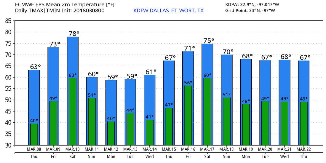 Look for the last Texas Weather Discussion Video for the week tomorrow by 7PM! Next week, we will be on spring break schedule, which means videos and blog updates will come by 4PM.
Chilly Start - Most places are starting the morning out in the upper 40s to low 30s. Cold air advection will keep us in the upper 50s today. We will only see a few spots hit 60 degrees for the high. Late Freeze Incoming? - From a trough in the north, and another deep nor'easter forms just off of the Atlantic Coast, a little bit of cooler air will be pushed into the state during the morning hours. Highs will only be in the upper 50s with abundant sunshine. On Thursday morning, we turn colder, and temperatures will fall into the mid 30s in most places, with some reaching down into the low 30s. Some isolated freeze spots will be possible early Thursday morning, with patchy frost possible for parts of the region. Then we warm up on Friday morning, with lows only in the upper 40s. Highs will be in the upper 60s and low 70s on Thursday and Friday. We are forecasting a mix of sun and clouds on both days, with more clouds than sun on Friday. The Weekend - Clouds will stick around on Saturday, and moisture returns, which means we will deal with a few isolated showers and thunderstorms at times during the day. Most of the rain stays to the east of DFW. Some thunder is possible, but for now, the severe weather threat looks fairly low. We will be in the upper 70s/lower 80s on Saturday, but cooler air gets pulled into the state on Sunday, and we will be in the mid 60s with a mix of sun and clouds. Next Week - Not much change. We stay dry with a mix of sun and clouds for all of next week. Temperatures will be in the mid 60s for most of the week, increasing to the low 70s on Thursday and Friday. See the Texas Weather Discussion Video for more details. 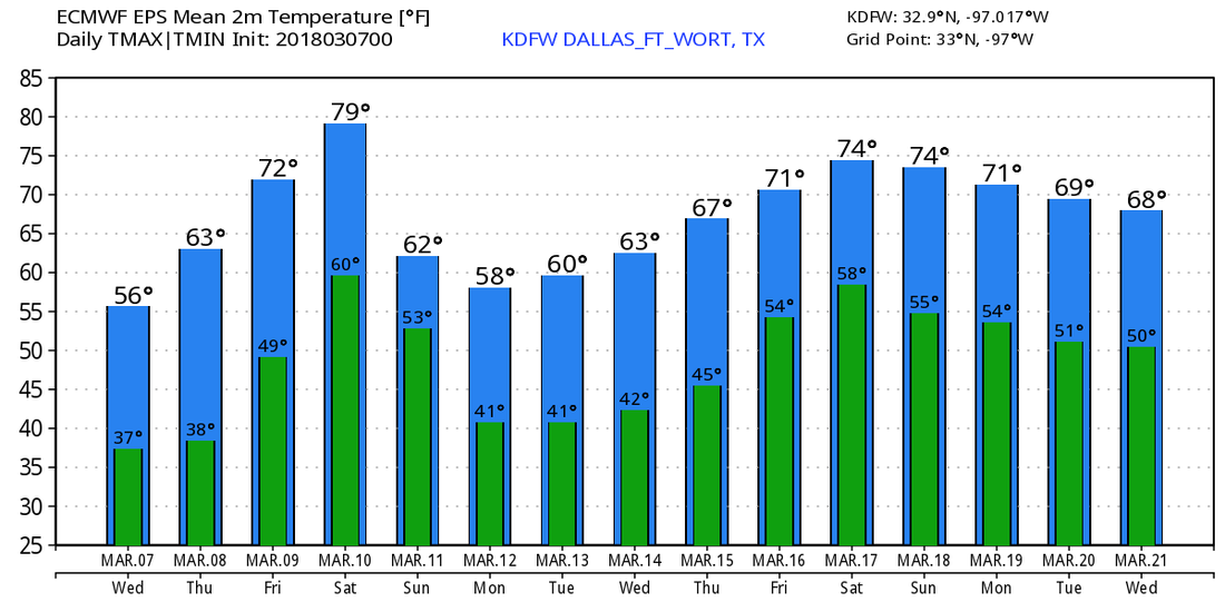 Overnight, we will fall to near freezing in DFW with frost likely, and a freeze at DFW Airport is possible. We will climb to the upper 50s tomorrow afternoon with plenty of sunshine. We will fall back to near 38° tomorrow night, but clouds will quickly roll in by 3AM. Thursday will be a mainly cloudy day with highs in the mid 60s across the area. A few of our far western counties may see some sun by afternoon, but DFW will remain cloudy all day. No rain is expected. Skies will clear late Thursday evening (near 10PM) and we will fall back to near 45° Friday morning with sunshine. By midday, clouds will quickly increase and the afternoon will be quite cloudy and breezy. A few sprinkles are possible east of Dallas in the better moisture content. We may reach 70° by Friday afternoon especially west of DFW. Skies will remain cloudy Friday night and we will only fall to the upper 50s and lower 60s. Saturday will be mainly cloudy with a 30% chance of thunderstorms. With some instability near 1,500 J/kg, there will be a severe risk. The main storm and severe risk will be east of DFW, but as a dryline moves in near 2PM, isolated to widely scattered storms will develop along the dryline with a few strong producing hail and high winds in DFW. We will remain cloudy Saturday night and clouds will be with us all day Sunday. More clouds and a low chance of rain next Monday with much colder air in place. Highs will be in the upper 40s with a few sprinkles or showers. No winter weather is anticipated at this time.
No sign of snow or ice anytime soon. -Jonathan |
Archives
April 2024
Categories |
 RSS Feed