
|
Even Chillier Start - If we take a look at our upper air pattern, the trough to the northeast that is associated with the Nor'easter along the Northeastern Coast is actually helping to pull some cooler air into the south. Temperature range from 34 in Glen Rose to 50 in Dallas Love Field. After the morning, we should turn pleasant and breezy with afternoon highs in the mid 70s. Tomorrow & Friday - Not much change. We continue to forecast chilly nights and pleasant days this week. Both days should be filled with plenty of sunshine with highs in the low to mid 80s. A few spotty showers could develop during the afternoon, but most places will stay dry. The Weekend - Saturday will be very dry and mild with highs in the mid 80s. Our unsettled weather pattern begins on Sunday. In the upper air flow, a likely Polar Vortex splits in western Canada, then begins to track to the south and east. This will set up a southwest flow aloft, similar to what we saw that caused excessive rainfall in mid February. We will deal with scattered showers and storms through the afternoon, some could turn strong to marginally severe. Highs will still be in the low to mid 80s. Next Week - Our unsettled weather pattern continues; Trough in the southwest, ridging in the east. For now the upper air pattern will continue to favor scattered to numerous showers and storms throughout the week, finally ending on Friday. Highs should be in the mid to upper 70s during the early half, falling to the upper 60s during the latter half of the week. See the Texas Weather Discussion Video for more details. 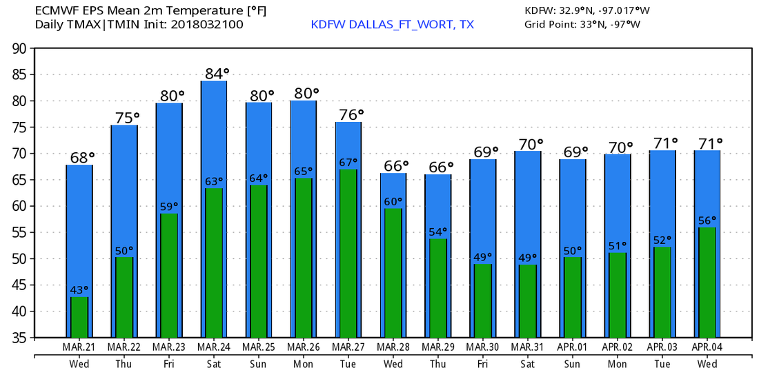 |
Archives
March 2023
Categories |
 RSS Feed
