
|
The weather the next few days will be dry and cool with highs in the 60s today, 50s tomorrow, 60s on Thursday, and 70s by Friday. Cloud cover may hold down temperatures a bit on Thursday and Friday.
Near 2pm Saturday a cold front approaches from the west and northwest. A few isolated storms will develop along the front and a few may turn severe. Large hail and damaging winds are the primary risk. Coverage will be less than 25%, with higher coverage well east of Dallas. No sign of winter weather anytime soon, but frost is possible tonight! -Jonathan Williams Mild Morning - Temperatures are in the mid to upper 60s in most places in north Texas, with Dallas Love Field already reporting 70 degrees as of 5:06 AM. However, we should reach our high temperature this morning as a cold front comes through. Temperatures will start to go the wrong way, and we should fall to the mid to low 60s during the afternoon and evening hours. We will mostly see a mix of sun and clouds throughout the day. Tomorrow will be a day with abundant sunshine with afternoon highs in the mid 60s. We start the day in the upper 30s to low 40s. Wednesday Through Friday - Not much change. We will have to watch for the potential for a light freeze in some places early Wednesday and Thursday morning with temperatures dropping to the mid 30s with some spots in the low 30s and upper 20s. Thankfully, the cold morning temperatures will give away to sunny skies and comfortable temperatures with highs in the low to mid 60s on both days. We turn mild on Friday with highs reaching the mid 70s and lows in the mid 40s. The Weekend - We turn mild on Saturday with a mix of sun and clouds. Highs will be in the upper 70s, with some places seeing 80s for the first time this year. A cold front comes through Sunday morning, which should drop highs to the mid 60s on Sunday. We will see a mix of sun and clouds on both days. Next Week - The early part of next week looks dry with afternoon highs mainly in the low to mid 60s with sunshine in full force. No signs of any severe weather concerns for at least the next 10 days. See the Texas Weather Discussion Video for more details. 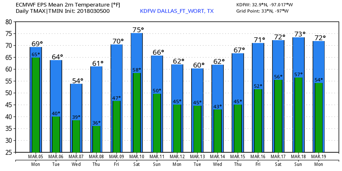 The clouds have been widespread this morning and this trend will continue through the next 24-36 hours. Some drizzle is out there now, but scattered (40%) showers and thunderstorms will develop this afternoon. While severe weather is not expected, a few strong storms are possible producing gusty winds, heavy rain, small hail, frequent cloud to ground lightning, and very loud rumbles of thunder! Any (low) severe risk will remain well north of our area closer to the upper level system. A weak cold front will move in tonight, possibly with a skinny line of showers and storms along it. A few strong storms are possible, but severe weather is NOT expected. Some storms may produce brief heavy rain and gusty winds, however. All thunderstorms will push east of the area tomorrow morning, but clouds will hold very firm through the day tomorrow. We may see a hour or two of near midday, but clouds will roll in ahead of our next cold front by 2PM, so mostly cloudy weather will prevail. A few sprinkles are possible with this front, but no measurable precipitation is expected. I cannot completely rule out a shower or two, but coverage will remain less than 10%. Skies will clear late tomorrow night, but the cold air behind the front will be delayed. Highs will be in the mid 60s, but we will fall into the lower to mid 30s Tuesday night with another freeze possible, but we will only rebound to the mid to upper 50s Wednesday afternoon, with our western and southern counties reaching the 60s. We will fall back to near freezing Wednesday night, and we will reach the 60° mark by Thursday. Sunshine will continue to be the player from Tuesday to Thursday. Ahead of our next cold front/upper level system, clouds will return by Friday with widespread cloud cover and isolated showers and thunderstorms. With a dryline and a cold front along with a strong system, we will watch for severe weather to return by Saturday. CAPE values will be approaching 3,000 JKg and with strong shear, we will likely have a potential of rotating supercells Saturday afternoon and night. It's too early to tell which types of severe weather will be the primary risks, but all modes of severe weather including large hail, damaging winds, tornadoes, and flash flooding appear possible. This does have the potential to be our first significant severe weather event of the season. Thunderstorms will he scattered in nature Saturday afternoon, with a line of strong storms during the overnight hours. I'll keep you updated on this potential.
Planters: With frost and freezes back into the forecast this week, please abstain from planting anything. March still can be freezes and I do believe this may not be our last freezes, so again, please to not plant yet! I'll let you know when it is safe. Regarding the seven day forecast: I hope to have it uploaded today, and follow my twitter @apexwx2 for when I say it's been released. It's been a very busy week and I haven't had much time! If it's not uploaded today (and I plan to have it uploaded soon) it will be uploaded tomorrow! Have a blessed Sunday! ;) - Jonathan Williams Cold Start - Temperatures are in the upper 30s to mid 40s range for most of North Texas due to the cold air advection from the cold front. Luckily, today will be an absolutely pleasant day with abundant sunshine with highs in the mid 60s. The Weekend - Same deal tomorrow - chilly nights, pleasant days ahead. We project a high of around 68 on Saturday with some places touching 70. We could see a mix of sun and clouds during the day. We will need to mention the chance of isolated showers and thunderstorms during the afternoon and evening hours on Sunday. Some of those storms could turn marginally severe with the possibility of large hail with the isolated severe storms. The SPC has a marginal risk for severe storms defined for much of the southern and central plains... 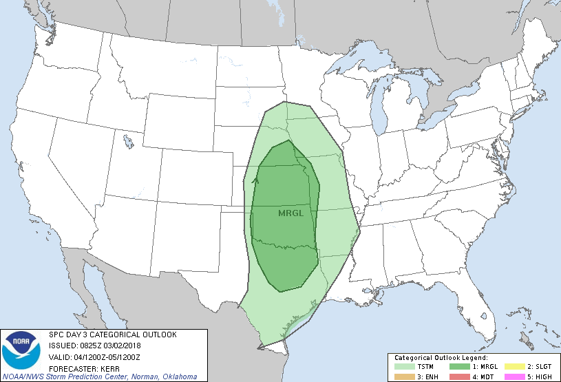 Most rain amounts should stay below 1/10th of an inch, and afternoon highs will be in the low 70s. Next Week - For the first time in a while, next week will be a completely dry week with very little to no rain expected. Expect cool nights and pleasant days ahead with afternoon highs in the mid 60s and morning lows in the low to mid 40s. See the Texas Weather Discussion Video for more details. 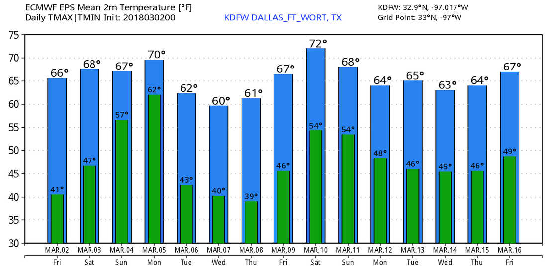 On This Day in 2012 - A deadly tornado outbreak occurred over a large section of the Southern United States into the Ohio Valley region. The storms resulted in 41 tornado-related fatalities, 22 of which occurred in Kentucky. Tornado-related deaths also occurred in Alabama, Indiana, and Ohio. The outbreak was the second deadliest in early March for the U.S. since official records began in 1950. This was a "High Risk" Day issued by the Storm Prediction Center.
Radar Check - A few storms are still in progress this morning for areas to the east of DFW... 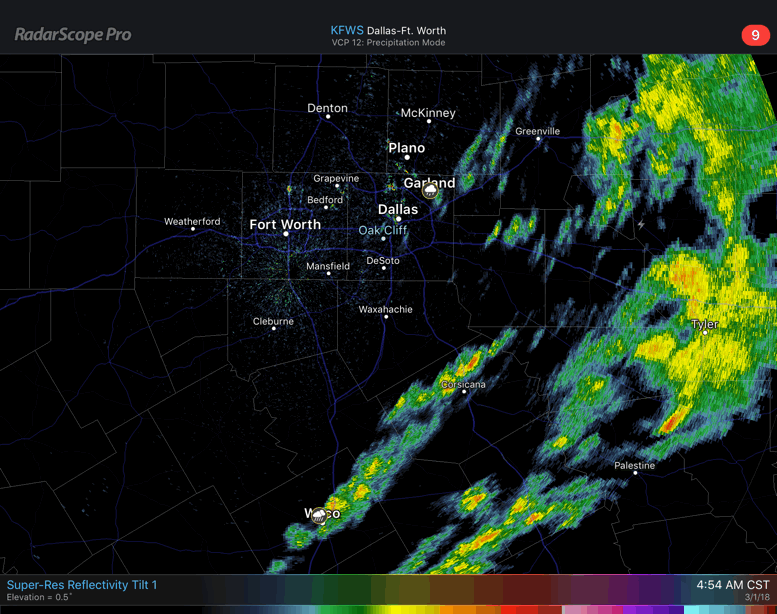 Once the activity tapers off this morning, the rest of the region should dry out and we should reach the mid 60s this afternoon with a mix of sun and clouds. Happy Meteorological Spring - March 1st marks the beginning of Meteorological Spring here in the US. This is different than the regular astrological spring season, which typically begins later in the month. We are starting to warm up, as average temperature climb to 69 this month, 77 in April, and 84 in May. We will start to see more rain, despite this February being the wettest February on record for DFW. With the beginning of Meteorological Spring, that usually marks the beginning of the spring tornado season. On average, Texas usually sees about 11 tornadoes this month. That number quickly jumps to 28 in April, and 44 in May. The tornado season in Texas usually peaks at around mid April to late May, before things get quiet again in June. So expect to see an increase in severe weather going forward. Make sure that you visit the Severe Weather Preparedness tab on the website for more details to keep you and your family safe from the storms. Friday and the Weekend - Not much change. We will continue to remain dry with highs in the mid 60s with a mix of sun and clouds. We will continue to forecast cool nights and pleasant days ahead. Sunday will be mostly cloudy with a chance for a few showers during the afternoon and evening hours. Highs should be in the low 70s. Next Week - Next week will be a mostly rain-free week with highs in the low to mid 60s with lots of sunshine. Once again, we will continue to forecast cool nights and pleasant days ahead. No signs of any major severe weather issues, or any brutally cold snaps at this time. See the Texas Weather Discussion Video for more details. 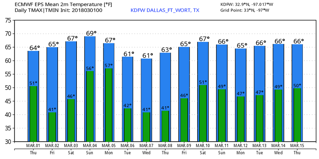 |
Archives
March 2023
Categories |
 RSS Feed
