
|
Radar Check - Heavy rain continues to move to the northeast this morning...  We will see rainfall increase throughout the morning hours, with a new batch of rainfall developing later this morning. Don't be surprised if some of those storms are on the severe side with mainly large hail and damaging winds possible. The tornado potential is very low, but not zero. Timing - By 8AM, we will see discrete thunderstorms attempting to initiate ahead of the main rain mass. Those storms are more likely to produce large hail and damaging winds. These storms will merge with the heavy rain to the west, producing a more linear mode of strong to severe storms. This is when the threat of damaging winds is maximized. We will continue to see strong to severe storms during the afternoon, before tapering off in the evening. The temperature will stay in the low 70s today. Tomorrow - Our last round of showers and thunderstorms will arrive during the pre-dawn hours. We will see rain for most of the morning, then we will clear out to dry conditions during the evening with highs in the mid 60s. The rest of the week will give out to abundant sunshine with highs in the low 70s. The Weekend - Not much change. We will continue to stay sunny with afternoon highs in the mid to upper 70s. No sign of any widespread rain during that time period. Next Week - Despite a few clouds, at least the early part of the week looks dry with afternoon highs in the low 70s. We will continue to forecast cool nights and pleasant days ahead. See the Texas Weather Discussion Video for more details. 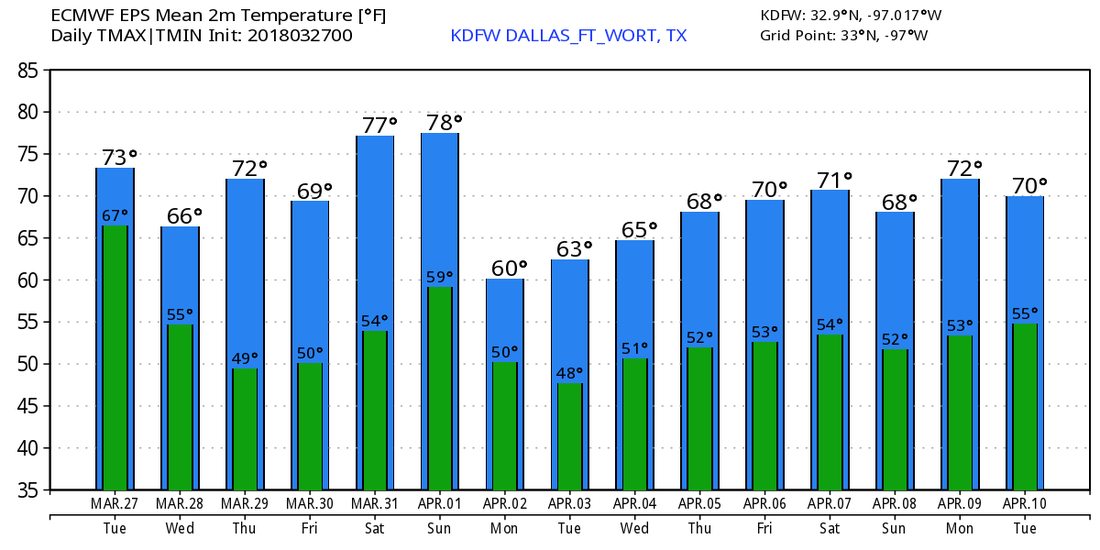 |
Archives
March 2023
Categories |
 RSS Feed
