
|
BROKEN RECORD: Weather for North Texas will not change much through the weekend. Look for the typical summer time weather; hot and humid days with a mix of sun and clouds featuring daily chances of spotty showers and storms. Most of the storms will spawn during the late afternoon and evening hours, but a late night or morning shower is not out of the question. Due to the small mesoscale features, there is no way of knowing exactly when they form, just keep an eye on the radar in case you have outdoor activity planned. Highs will be in the 90-95° range through Sunday. FOURTH OF JULY WEEK: Not much change. There will be variations of the number of storms and placement of them each day, but no way of determining them as of now because of small scale features once again. As a result, we will continue to forecast typical summer time weather for the foreseeable future; mix of sun and clouds, fair nights with daily chances of spotty isolated showers and storms. Note that the prime time for spotty storms to develop is from 12:00 PM to 10:00 PM, but do keep in mind that early morning or late night storms are never ruled out. Highs will be in the low 90s throughout the week. See the Texas Weather Discussion Video for more details. 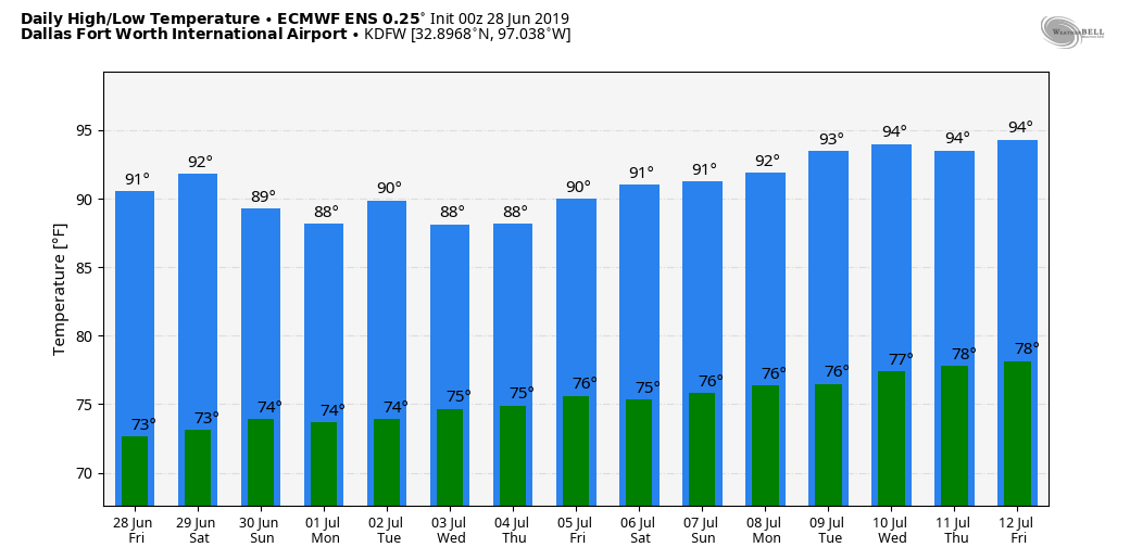 ISOLATION: If you don't truly believe in the isolated, sometimes sporadic nature of the showers and storms in the summer time in Texas, yesterday in Cedar Creek, a few miles to the southeast of Austin, a spotter measure 1.72". However, a few miles to the east near Wyldwood, a reporter measured absolutely no rainfall.
I will be on vacation next week... my next Texas Weather Discussion Video will be posted here by July 8. Have a great weekend and Fourth of July! SUN, HEAT, A STORM: In case you haven't noticed already, North texas will be in a routine summer weather pattern for the foreseeable future. The mid-latitude westerlies are well to the north, but that isn't stopping storms from developing in Central Texas today, and we will once again deal with random, spotty showers and storms during the afternoon and evening, mainly over our southern counties. The chance of one spot getting wet is only in the ten percent category, and the high this afternoon will be in the low 90s. TOMORROW THROUGH NEXT WEEK: We will roll with a persistent forecast over the next week; mix of sun and clouds, hot, humid days with daily chances of "spotty, mostly afternoon to evening showers and thunderstorms". Some outflow winds are possible with these storms, and we will have no way of knowing exact start and stop times and where they form. Of course there will be some differences of storm placement each day due to small scale features, but will have no way of knowing in advance. Odds of any one spot getting wet each day will still be in the 10-20 percent bracket, and afternoon highs will be in the low 90s, typical weather for late June here in North Texas. See the Texas Weather Discussion Video for more details. 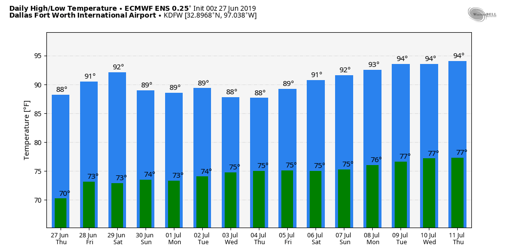 TROPICS: The Atlantic Basin continues to remain very quiet, and no new tropical cyclones is expected through next week.
HOT AND HUMID SUMMER WEATHER: In the moist airmass over North and Central Texas we have a few spotty showers and storms on the radar this afternoon. They are generally moving to the north, and will not last very long at all. Spotty storms will form later this evening, and the best chance of any one spot getting wet is only in the 20 percent range. Expect a continuation of mostly sunny skies with highs very close to 90°. The weather will remain the same tomorrow and Friday; mostly sunny skies with "isolated, mostly afternoon and evening spotty showers and storms". Highs will remain in the low 90s. THE WEEKEND: The hot, humid summer weather continues. We will have a few random, spotty storms around on both days, but just know that there will be no way of knowing exactly where and when they form. Highs will remain in the 90-95 degree range for most places. NEXT WEEK: We will continue with a typical summer time forecast for the Fourth of July week; hot, muggy, mix of sun and clouds with daily chances of "spotty, mostly afternoon and evening showers and storms". Each day will feature highs in the low 90s. See the Texas Weather Discussion Video for more details.  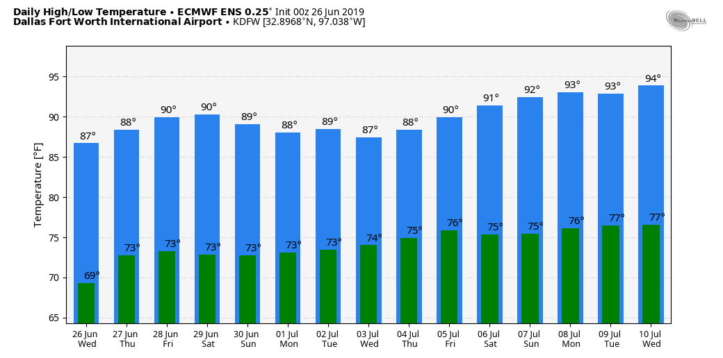 TROPICS: The Atlantic Basin continues to remain very quiet, and tropical cyclones are not expected for the next ten days.
SAL: The Saharan Air Layer will move into a decent chunk of Texas this evening. If you have not heard of this before, it is not common, but not unprecedented. In the long days of summer, dry air from the African deserts move through the Atlantic and the Caribbean, curving into the Gulf of Mexico in high levels. When the SAL creeps into the southern US, because the dust is 5,000 and 20,000 feet in the air, the main effect comes from beautiful sights at sunrise and sunset. HOT AGAIN TODAY: Look for a high around 90° this afternoon with a mostly sunny sky; any scattered showers and storms later today will be over the southern half of the state. Isolated storms are still possible across southern parts of North Texas, however. The SPC has a "marginal risk" of severe storms defined for the southeastern portions of the state. 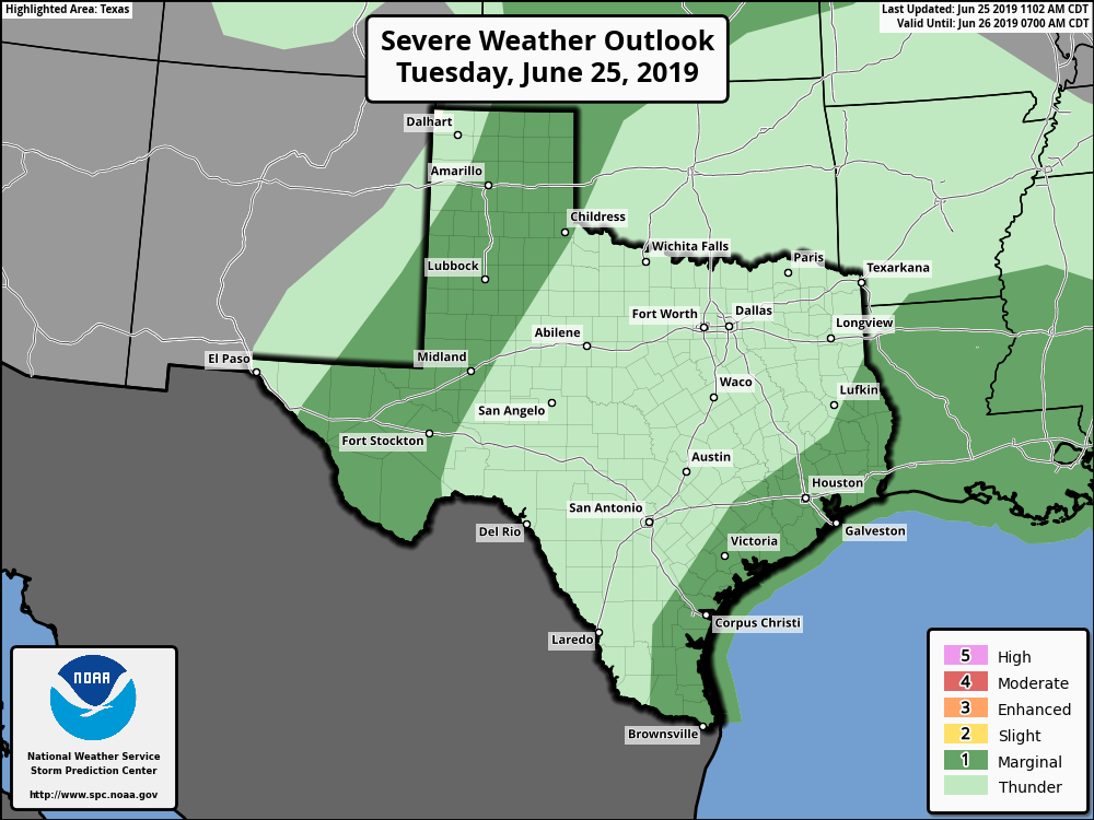 Where storms develop over that region they could produce gusty winds and hail. REST OF THE WEEK: Look for routine summer time weather for the region tomorrow through Friday with hot and humid weather with the rest of a few isolated showers and storms during the afternoon and evening hours. Mix of sun and clouds, fair nights, highs in the low 90s. THE WEEKEND: We will mention the risk of scattered, mostly afternoon showers and storms on Sunday between 12PM through 12AM. The chance of one spot getting wet is in the 20/30 range, and afternoon highs will be in the low 90s, typical Texas Weather for the end of June. NEXT WEEK: We will continue to stick with a consistent forecast for the Fourth of July week... mostly sunny, hot and humid days with "isolated, mostly afternoon showers and storms" everyday. Highs will continue to be in the low 90s. See the Texas Weather Discussion Video for more details.   SAL: The Saharan African Dust has moved into parts of the Deep South and will move into parts of North Texas tomorrow evening. The highest concentration of dust will keep to the east. This is what is keeping our tropics quiet for June. 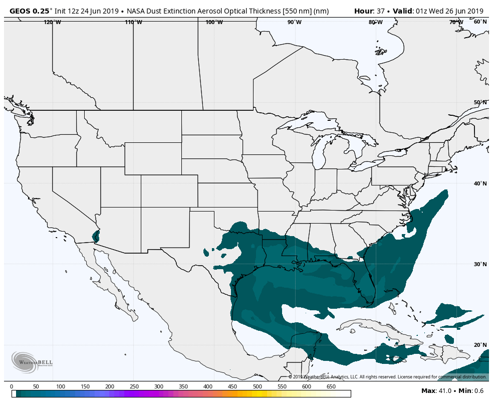 RADAR CHECK: Showers and thunderstorms continue to exit the North Texas region this morning. Some redevelopment of isolated showers and storms are possible as usual during the afternoon and evening, but most places stay dry.  Clouds will eventually clear the area, and afternoon highs will be in the mid to upper 80s. MIDWEEK: Not much change in the forecast. Every day will feature much of the same weather; mostly sunny and hot with daily chances of "isolated, mostly afternoon and evening showers and storms". We will dry out by the latter half of the week. Highs will be in the low 90s each day. THE WEEKEND: Not much change. Expect much of the same weather featuring a mix of sun and clouds and a chance of showers and storms on Sunday. Afternoon highs will be in the low 90s. NEXT WEEK: We actually stay dry for the early part of next week with mostly sunny skies and highs in the low 90s. No signs of any excessively hot weather for the next ten to fifteen days. See the Texas Weather Discussion Video for more details. 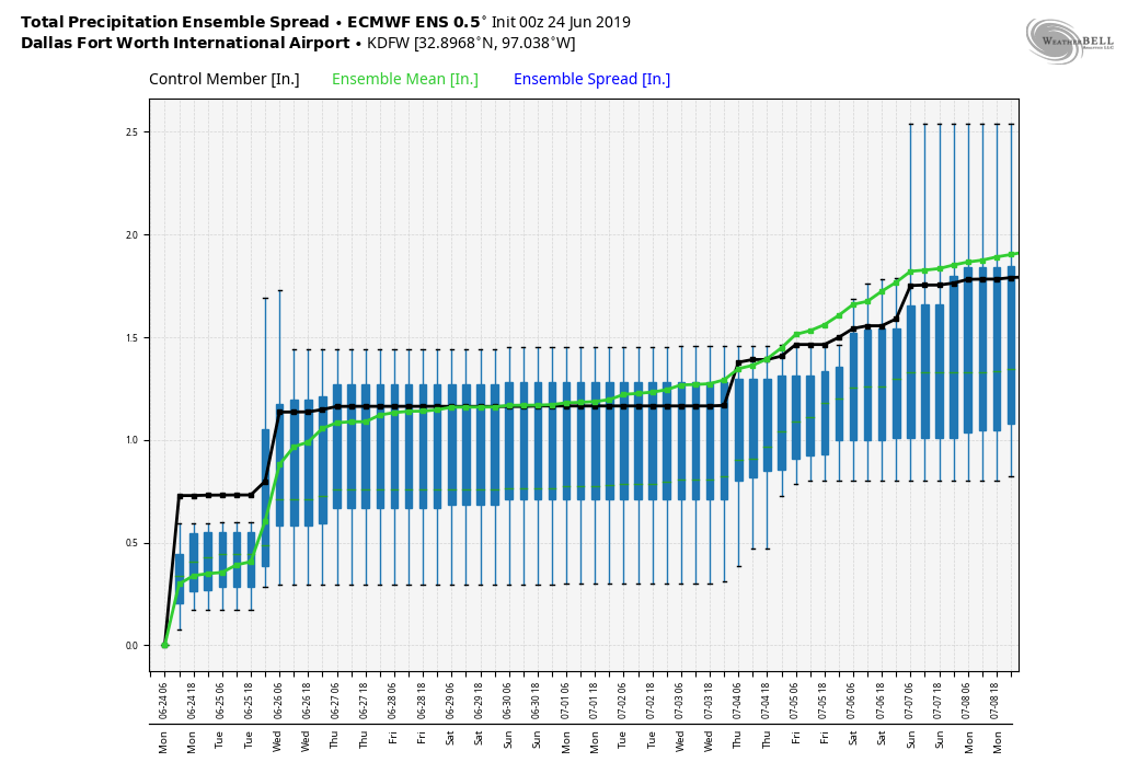 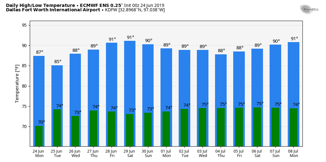 TROPICS: The Atlantic Basin continues to remain very quiet, and tropical cyclone development is not expected for this week or the weekend.
*I am still leading at the drum major camp in Denton, so no Texas Weather Discussion Video today* STILL HOT: Temperatures are currently in the low 80s this morning, which is a good indicator that the afternoon and evening will be very hot. The air remains very moist across North Texas, and today will be another mostly sunny and hot day with highs in the mid 90s with heat indices in the 105-110° range this afternoon. The Heat Advisory has been extended until 7pm today to address this. 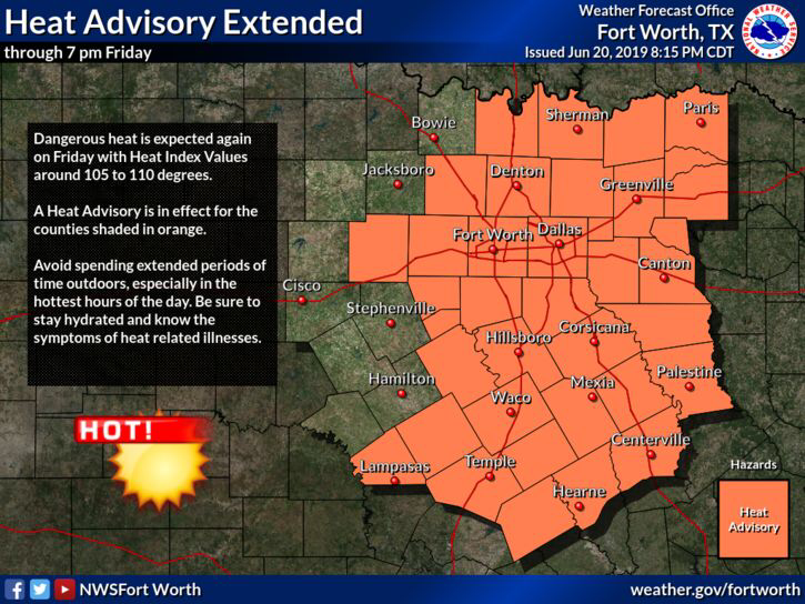 THE WEEKEND: Mostly sunny and warm weather continues tomorrow with highs in the mid 90s again. Then, moisture levels will rise on Sunday, and we will mention the chance of a few widely scattered showers and thunderstorms by the morning and afternoon. The high Sunday will be between 90-95°. NEXT WEEK: Routine early summer weather will be the story for the early part of next week; mix of sun and clouds and humid with daily chances of “isolated, mostly morning/afternoon showers and storms”. Highs will be in the low 90s, and overnight lows will be in the mid 70s. We should turn mostly dry for the latter half of the week. 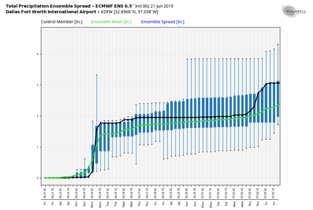 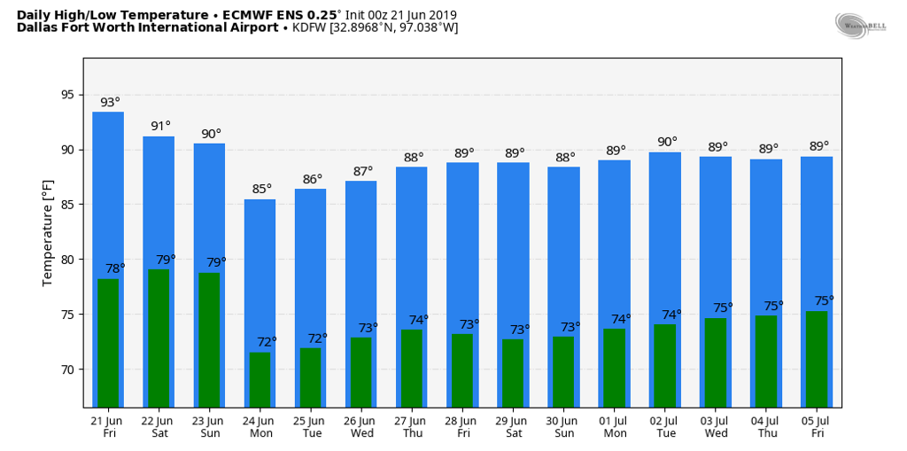 TROPICS: The Atlantic Basin continues to remain very quiet, and no new tropical cyclones is expected to develop this weekend.
SUMMER BEGINS: The official start of the summer solstice lies today at 10:46 AM, which marks the beginning of astronomical summer, which lasts through September 23. Astronomical seasons are different than meteorological seasons, as they are defined by Earth’s natural rotation around the sun, which we define as two solstices and two equinoxes. I will be taking my vacation week next week, so expect the next Texas Weather Discussion Video and blog update from me by Monday, the first of July. Enjoy the weekend! *I am currently leading in a camp in Denton, so no Texas Weather Discussion Video today* MILD MORNING - As expected, temperatures are currently in the mid 70s across the region this morning, with some of the urban areas already seeing 80° at 5:25. Expect sun in full force today with very little clouds in place. After combining the elements of summer and spring time weather yesterday, we will turn very hot and humid this afternoon with highs in the mid to upper 90s today, about five or so degrees above our average high of 92° for June 20. However, it will feel much warmer than 97° due to heat indices around 105-107° for most communities. To address this risk, National Weather Service has issued a Heat Advisory for the greater DFW Metroplex, excluding the the northern counties. 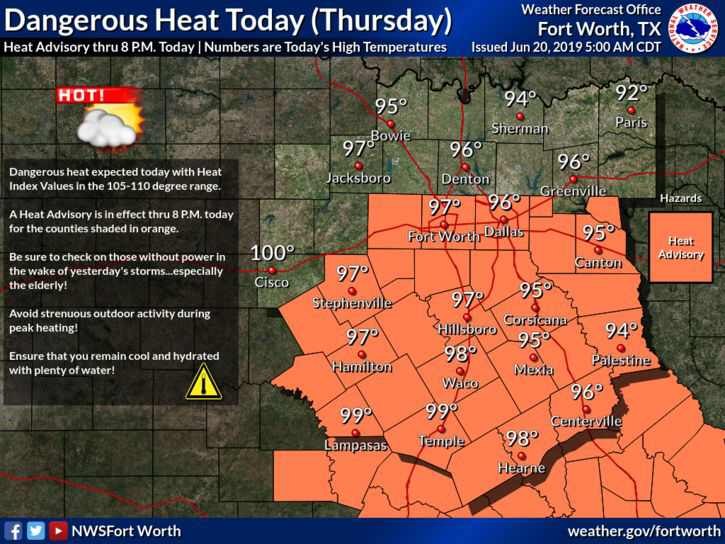 It will be slightly cooler and breezy tomorrow, but highs will still be in the mid 90s with mostly sunny skies. Overnight lows will be in the low 70s. THE WEEKEND: Only slightly cooler conditions are forecast for the weekend, so we will maintain highs in the low 90s. We will bring back the early season daily chances of “isolated, mostly morning/afternoon showers and storms”. Widespread chances of rain looks low, but a microburst and some gusty wind is possible with some storms. NEXT WEEK: A relatively moist airmass will still be over North Texas for at least the beginning of the week, which means we will have the daily chances of “isolated, mostly morning to afternoon showers and storms”. Odds of any one spot getting wet is in the 20-30 percent range. We do turn dry by the latter half of the week featuring a mix of sun and clouds. Highs will be in the low 90s each day.   TROPICS: All is quiet in the Atlantic Basin, and tropical cyclone development is not expected for the next week.
RADAR CHECK: A complex of loud showers and thunderstorms that we probably all woke up to at 2:00 in the morning is moving to the east this morning. The cloud cover as a result should begin to decrease as we progress throughout the day.  SEVERE WEATHER POSSIBLE AGAIN THIS EVENING: Before you read any further, understand that this is definitely something that we do not deal with every year; a late spring severe weather setup. This just goes to show you that severe weather can happen at any time of the year, and is not 'unprecedented' or 'uncommon', as some people like to think. Keep in mind that this forecast can and will change, so be sure to stick with our twitter, facebook, and the blog to stay up to date. Regardless, we have the potential for significant severe weather this afternoon across North Texas. The Storm Prediction Center upgraded portions of North Texas to an 'enhanced' (level 3 of 5) risk of severe storms this afternoon and evening. This does include the entire Dallas/Fort-Worth Metroplex, extending to the east near Mount Pleasant. The standard "slight" (level 2 of 5) risk of severe storms runs through Abilene and surrounds the enhanced risk area, then runs east through the Ark-La-Tex region. A "marginal" (level 1 of 5) risk of severe storms surrounds the slight and enhanced risk areas and runs a bit farther to the northeast and west. 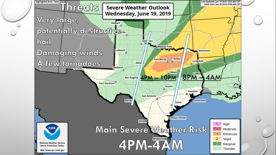 As I say with any severe weather risk, please be advised that it is bad practice to get fixated with these risks. Storms do not know where these lines and colors are and do not follow a map. Additionally, these severe weather setups this late in the season can change, even with the most minute details, so it is imperative that you are always on our feed today. HOW IT LOOKS NOW: The storms that moved through the region this morning actually do play a role in how storms develop this afternoon. The storms left a few outflow boundaries for the storms to "play around with". These are the areas where the storms will initiate this afternoon and may tap on to some enhanced low-level shear. We will talk about that in a second. Once the clouds start breaking across the metroplex and we see mostly sunny skies, highs will be in the mid to upper 90s this afternoon in a very humid airmass. It will truly feel like a hot summer day this afternoon. This will not be good in this scenario, as that will be a catalyst for the atmosphere to become extremely unstable this afternoon and evening across North Texas. Surface-based CAPE values will exceed 6000 j/kg in some places, making for a "powder-keg" situation for the region, and storms may turn nasty if they take advantage of it. TIMING: Although computer models are painting a different picture, we expect severe thunderstorms to initiate in West Texas at around 4:00 PM this afternoon. Keep in mind that this development will likely be explosive and become severe very quickly, since we will not have a capping inversion to keep the storms in place due to an extremely unstable airmass. Our main severe weather risk will last until 9-10PM for most of the metroplex, but most of the North Texas region can expect severe storms anywhere from 4PM to 4AM Thursday morning. THREATS: Supercell thunderstorms will develop this late afternoon and progress into the evening hours. These storms will have the greatest potential of producing very large hail up to the size of baseballs. Keep in mind that if we see a long-lived supercell, that one will have the highest probability of producing softball sized hail somewhere in the enhanced risk region during the late afternoon to early evening hours. Damaging wind and a few tornadoes will be possible as well. If any storms can interact with any greater weak low-level shear, then the tornado potential will be maximized in that zone. However, the extreme instability should compensate for the lack of low-level shear, so we will continue to mention the chance of a few tornadoes in North Texas this evening. Once the storms congeal into a cluster or a squall line, the threat for damaging winds and some hail will be maximized. The main batch of storms should move out of the state by midnight. RAIN: Heavy rainfall rates are possible with any severe storm today, and 1-2 inches of rain as a whole can be expected. We do not expect any widespread flash flooding issues, however localized street flooding is possible with heavy downpours. TAKE A DEEP BREATH: We are all too familiar with very large hail events across this region here in North Texas, and this is nothing out of the ordinary. Just take a deep breath, and make sure you protect your property for any hail in case of the worst-case scenario. Not everyone will get hail, so don't be upset if you do not get anything. Further, make sure you are staying up to date with the ever changing forecast. This means having a reliable way of receiving warnings. Every home and business should have a NOAA Weather Radio, but you should really consider investing in a great smartphone app like this one in order to receive warnings in a timely fashion. If you need some guidelines on how to prepare for severe weather, information can be found here. REST OF THE WEEK: Once the severe weather passes, the rest of the week will feature very hot, dry conditions with highs in the mid to upper 90s. It will feel more like a hot, summer day with heat indices in the triple digits. THE WEEKEND: Not much change. We do go back to seasonal averages for the year with highs in the low 90s with a mix of sun and clouds. NEXT WEEK: Most of next week will also be dry with highs in seasonal averages for this time of the year with daily chances of "isolated, mostly morning showers and thunderstorms". See the Texas Weather Discussion Video for more details.   CLEARING THIS AFTERNOON: Now that the morning rain has dissipated, we are left with a mix of sun and clouds, dry conditions, and highs in the low 80s by noon. Expect another warm up by ten degrees this afternoon with highs in the low 90s expected.  SEVERE WEATHER POSSIBLE TOMORROW AFTERNOON: After our usual round of morning showers and thunderstorms, we will deal with another threat of strong to severe storms for much of North Texas during the afternoon. The SPC currently has the standard "slight risk" (level two of five) of severe storms over all of the North-Central Texas region for the entire day on Wednesday... 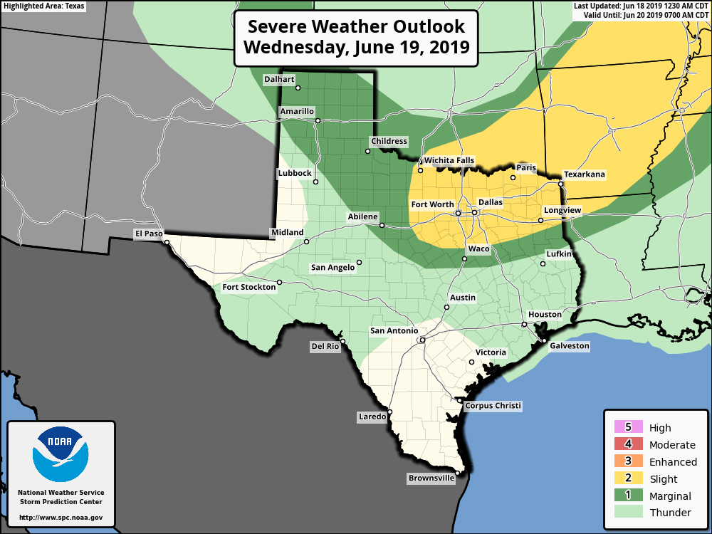 TIMING: Supercellular development is possible during the early afternoon beginning at around 3pm. Storms may quickly increase in number and turn severe during the evening. The best time for severe storms for the metroplex is from 3pm to 3am Wednesday morning. THREATS: Since storms will form in supercells/clusters, the main risk will range from large hail to damaging winds. Some very large hailstones is possible due to the storm mode and expected lapse rates. The tornado potential, on the other hand, remains very low, but not zero. Heavy rain is likely for communities that experience severe storms, but flash flooding is not expected. CALL TO ACTION: Be sure you have a reliable, robust way of receiving warnings before tomorrow. An outdoor warning siren should not be your primary method of getting warnings. Otherwise, you will have no hope of knowing when a severe thunderstorm is coming. Every home/business should invest in a NOAA Weather Radio. And, just in case, make sure you have your storm shelter ready. REST OF THE WEEK: The chance of showers and storms should diminish as we turn mostly sunny and very hot on Thursday and Friday. Highs each day will be in the mid to upper 90s, and it will feel like it is in the triple digits, so be sure to stay hydrated and prepare for the hot weather. THE WEEKEND: Not much change, mostly dry and sunny with highs in the low 90s, which is basically at seasonal averages for this time of the year. A few isolated showers and storms are possible early Sunday morning, but most of the weekend should remain quiet. NEXT WEEK: Much of the same, dry weather will continue for the last full week of June; mostly sunny, dry conditions, highs in the low 90s. See the Texas Weather Discussion Video for more details.  TROPICS: The Atlantic Basin is very quiet, and tropical cyclone development is not expected for at least the next ten days.
WARMING BACK UP: Temperatures are currently in the mid to upper 70s with a few 80 degree readings across the region. The air continues to remain relatively dry across North Texas, and today will be another sunny day with a high around 90°. THE WEEKEND: Mostly sunny, hot weather continues tomorrow with a high in the low 90s. Then moisture levels rise Sunday morning with the chance of isolated/widely scattered showers and storms during the pre-dawn hours. Then, a complex of storms move in from Oklahoma by the overnight hours. Some storms could be strong, which is why the SPC has a "marginal risk" (level 1 of 5) of severe storms for the metroplex. Rain will continue into the morning hours on Monday. The high Sunday will be in the 90-95 degree range with more clouds than sun. NEXT WEEK: Rain will continue to linger until the afternoon on Monday. Then, we go back to routine June weather through midweek with the daily chance of "isolated, mostly morning to afternoon showers and thunderstorms". Highs will be in the upper 80s to low 90s, and lows will be in the mid 70s. The storms each day will be fairly isolated and not widespread. See the Texas Weather Discussion Video for more details. 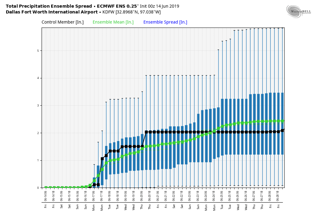 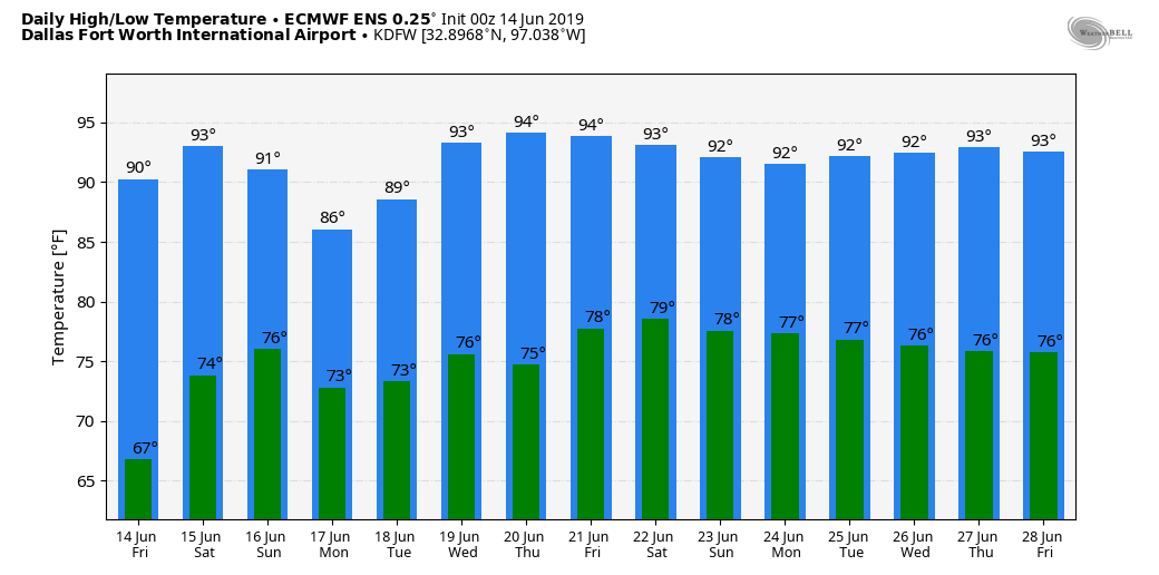 WONDERFUL WEATHER: The weather is very comfortable today with lots of sunshine, low humidity values, and not many clouds with temperatures in the mid 80s. There is nothing on the radar in the region this afternoon. Tonight will be clear with temperatures going back to the 70s with fair skies.  The sky will continue to stay mostly sunny tomorrow as we transition back to seasonal weather averages. We will still stay dry however, but an isolated shower or two can't be ruled out during the day. Highs will be in the low 90s. THE WEEKEND: We will mention the chance of isolated showers along the Texas Coast on Saturday, but most of the region will stay dry with a mix of sun and clouds along with highs in the low to mid 90s. Then, early Sunday morning, moisture levels will increase and we will bring back the chance of scattered, potentially widespread showers and thunderstorms regionwide. The high Sunday afternoon will be in the low 90s, and the chance of one spot getting wet is in the 50/50 range. NEXT WEEK: A moist airmass will cover much of North Texas through the week, meaning the daily chance of "scattered, mostly morning to afternoon showers and thunderstorms" will be in place for most of the week. Aside from that, expect a mixture of sun and clouds daily with highs inthe upper 80s to low 90s. See the Texas Weather Discussion Video for more details. 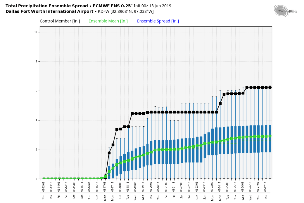 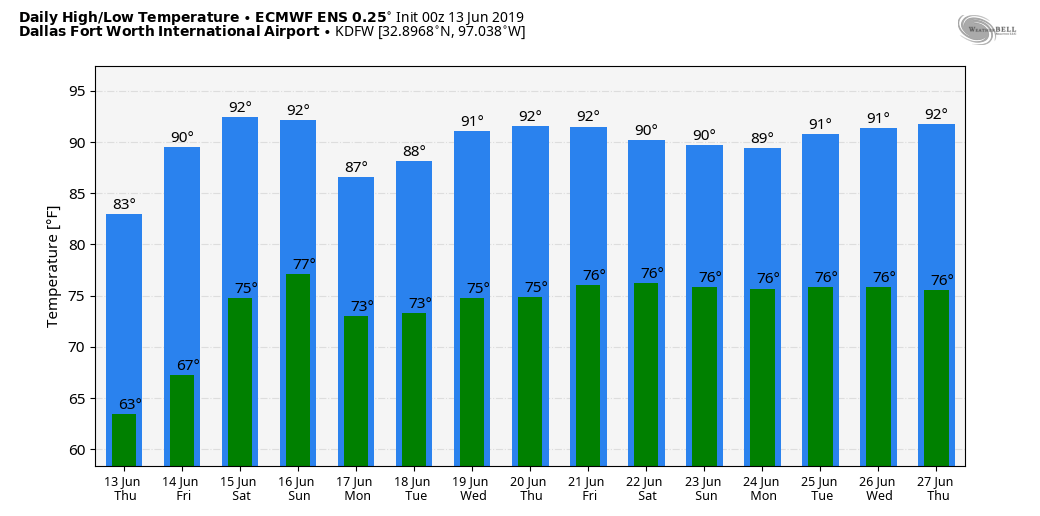 RADAR CHECK: We have some dying showers ongoing near Breckenridge and Graham, areas just to the west of the metroplex. These rain showers should continue to fizzle out as we head into the afternoon. Temperatures are 7-14 degrees below average across North Texas this morning with readings mostly in the mid 70s. Lower than normal dewpoints are making it feel like a fall day. We will hang on to the chance of isolated showers over our western counties this afternoon. Tonight should be mostly fair with a low in the low 60s.  REST OF THE WEEK: We get one more day of fall-like weather tomorrow with a mix of sun and clouds with highs in the mid 80s before returning to seasonal averages on Friday with highs in the low 90s with our usual daily chance of "isolated, mostly morning to afternoon showers." THE WEEKEND: Saturday will be mostly dry. Temperatures will rise into the low to mid 90s with a noticeable increase in humidity. Then on Sunday, we will mention a chance of scattered showers and thunderstorms in the morning as moisture levels rise to averages again. Sunday's high will be in the 87-93 degree range. NEXT WEEK: We will continue to maintain daily chances of "isolated, mostly morning to afternoon showers" for at least the beginning part of the week with a mix of sun and clouds each day. Highs will be in the upper 80s to low 90s. See the Texas Weather Discussion Video for more details.   COOL SUMMER DAYS: It doesn't really feel like early summer here in North Texas, as temperatures are in the low to mid 60s this morning with urban places in the low 70s. The cool weather trend continues today with highs in the low 80s with a mix of sun and clouds. The average high for DFW for June 11 is 91. REST OF THE WEEK: The only chance of rain we have this week is from a weakening complex of severe thunderstorms that will make its way towards the metroplex during the overnight hours. The complex will be almost non-existent by the time it makes it way towards North Texas. Some showers and storms will still be possible for our North and Northwestern counties tomorrow morning. Otherwise, the day tomorrow and Thursday will feature mostly sunny skies with highs in the mid 80s. FRIDAY AND THE WEEKEND: We return to seasonal averages during the weekend beginning Friday with highs in the low to mid 90s with mostly sunny skies. Our only chance of rain lies on Sunday where we return to our routine chance of isolated showers and storms during the morning and afternoon hours. NEXT WEEK: We go back to routine early summer-time weather here in North Texas with a mix of sun and clouds, humid, with daily chances of isolated showers and thunderstorms during the morning and afternoon hours. Highs will be in the low 90s each day. See the Texas Weather Discussion Video for more details.  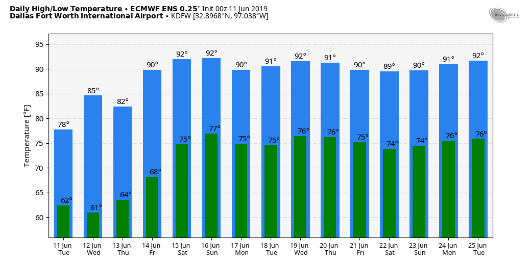 RAIN FREE DAY: With temperatures in the mid 80s this afternoon, we currently have no rain in the Metroplex, which marks day one of no rainfall, which may last for a few days. The sky will become somewhat cloudy tonight, with sunshine in full force by daybreak. REST OF THE WEEK: Drier air will continue to flow into the state from the north; each day will feature a mix of sun and clouds with highs in the mid to upper 80s. Rain chances will be minimal to none each day. Another surge of drier air will bring seasonal temperatures but lower humidity values to the region by Friday. Most places across North-Central Texas will wind up in the mid to upper 60s early morning. THE WEEKEND: Saturday will be nice and dry with seasonal temperatures and mostly sunny skies. The day should be hot with highs in the low 90s. Then on Sunday, moisture levels will rise, and we will mention the chance of scattered showers and thunderstorms with highs in the low 90s. The best chance of showers and storms Sunday will come during the morning and afternoon hours. NEXT WEEK: For now, it looks like routine early summer weather for North Texas featuring a mix of sun and clouds with daily chances of "isolated showers" during the morning to afternoon hours. Highs will be in the 90-95 degree range. See the Texas Weather Discussion Video for more details. 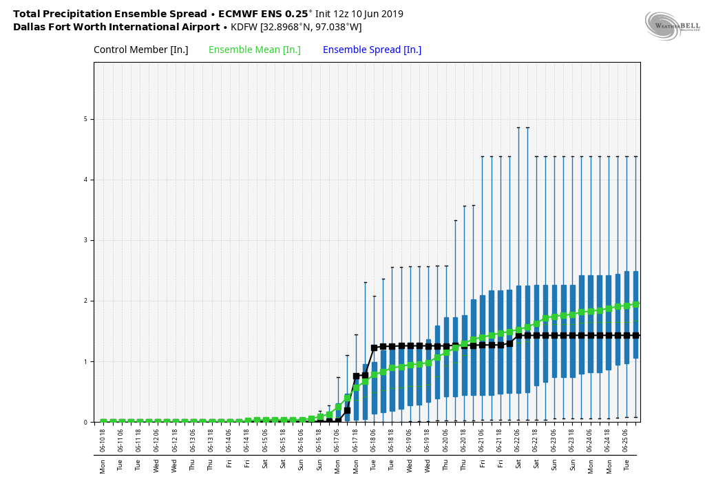 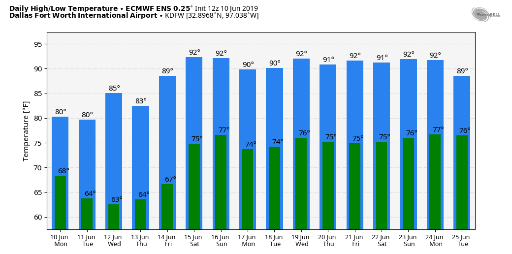 TROPICS: Wrapping up the first ten days of the 2019 Atlantic Hurricane Season, all is quiet in the Atlantic Basin, and tropical cyclone formation is not expected for at least the next ten days.
STILL NOT DONE WITH RAIN YET: We have only some showers in the northern part of the DFW metroplex this morning; we had an earlier batch of rain earlier this morning for our southern counties. We will be occasionally wet through Friday with rain at times along with a few thunderstorms. A few strong storms are possible over parts of North Texas today; SPC has placed a "marginal risk" (level 1 of 5) of severe storms over all of North Texas today. 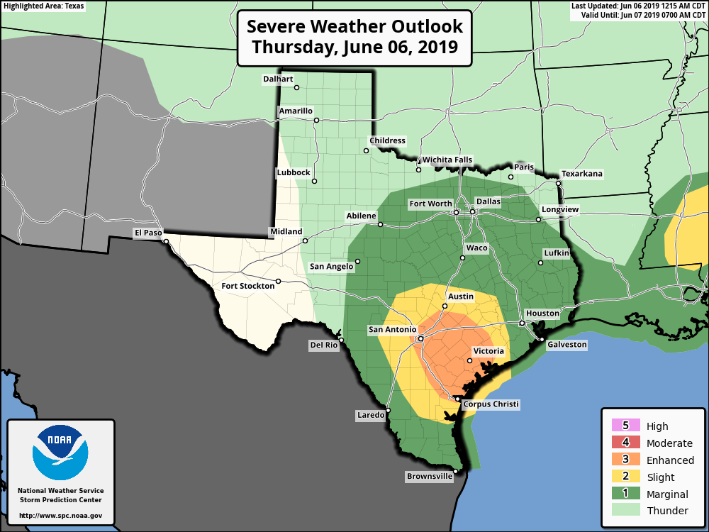 A few of the storms in our region could produce some hail at times later this afternoon and evening, but the highest threat of severe storms lies in the South Texas near San Antonio. Most communities will be in the upper 80s with a mix of sun and clouds. THE WEEKEND: We warm exponentially during the weekend featuring typical summer-like weather here in Texas; mix of sun and clouds, hot, and humid conditions with highs in the mid 90s this time, just a couple degrees above our average high. NEXT WEEK: Next week will feature drier weather than normal with mostly sunny skies everyday with highs in the upper 80s/low 90s. Expect at least a shower or two occasionally. See the Texas Weather Discussion Video for more details. 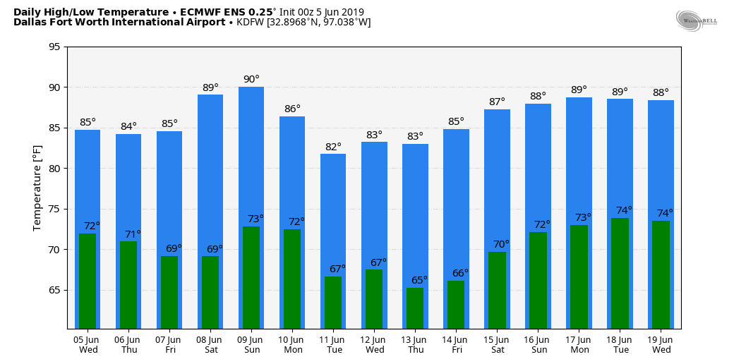 ANOTHER DRY DAY: Similar to yesterday, today will be another (mostly) dry day for the region. The sky will feature a mix of sun and clouds with a high in the low 90s in most areas. MORE RAIN MIDWEEK: Clouds will begin to increase across the state tonight into tomorrow morning, and we will subsequently introduce the chance of scattered showers and thunderstorms. We will continue to mention this pattern through Thursday with a mostly cloudy sky and occasional showers and thunderstorms, especially for our southernmost and easternmost counties in our region. No organized severe weather is expected, and heat levels will drop by a few degrees with highs in the mid to upper 80s. THE WEEKEND: We will mention unseasonably warm conditions following a tropical low with mostly sunny skies and only a few clouds. Highs will be in the mid 90s this time around, and moisture levels will come down a tad. NEXT WEEK: Showers and stomrs still remain possible on Monday and Tuesday, but should eventually thin out by midweek. Highs will be in the 90s Monday and Tuesday, and then close to 85 on Wednesday and Thursday. See the Texas Weather Discussion Video for more details. 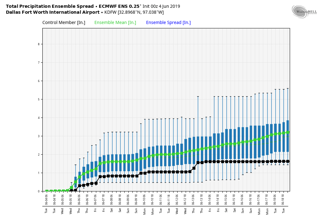 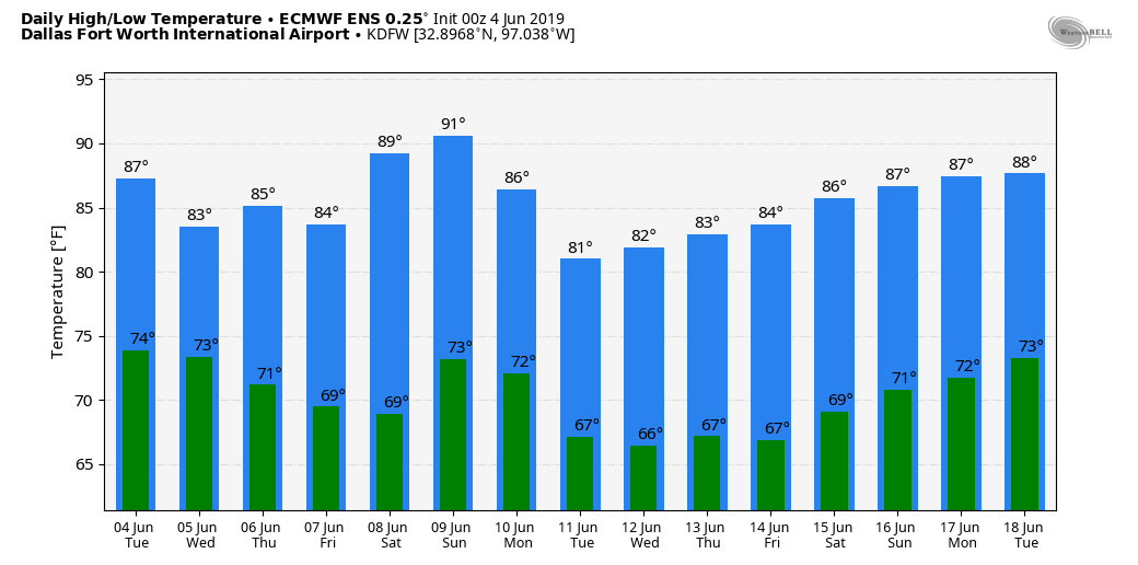 2019 HURRICANE SEASON: The first day of the 2019 Atlantic Hurricane Season was June 1st, which will run until November 30th. Long-term averages for the number of named storms, hurricanes, and major hurricanes are 12, 6, and 3, respectively. The 2019 Atlantic Hurricane Season names are Barry, Chantal, Dorian, Erin, Fernand, Gabrielle, Humberto, Imelda, Jerry, Karen, Lorenzo, Melissa, Nestor, Olga, Pablo, Rebekah, Sebastien, Tanya, Van, and Wendy. The disturbance in the Southwest Gulf of Mexico has a 50 percent chance of developing into a tropical depression or storm over the next 48 hours before moving into Mexico. One way or another, moisture from this low will move north through the Texas coast into the southeast US over the next 3-5 days, enhancing the rain coverage across South, Central, and East Texas, as well as the adjacent states. The rest of the Atlantic Basin is quiet. 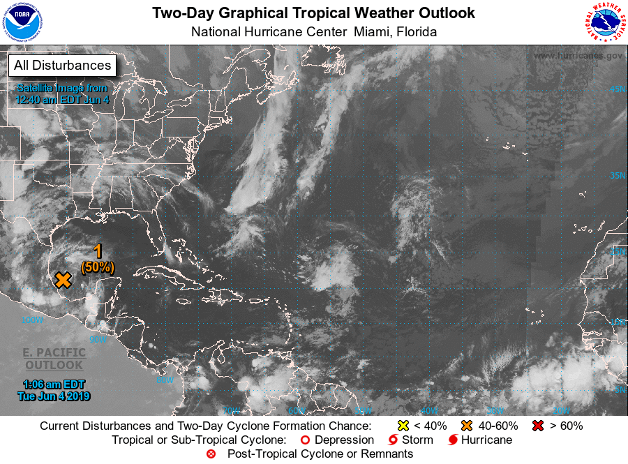 |
Archives
April 2024
Categories |
 RSS Feed