
|
As you might recall, last week I called for some prolonged heavy rain events and a wet pattern to last us into June. And, as you are probably well aware, it has been very dry and warm the past 3 days in DFW. So, in summary, I was wrong. However, so too were the models, as the ULL came through way faster and hammered Central Texas with severe weather and allowed the ridging to form, giving us a plethora of hot and mostly cloudless days to work with for the end of May. So, what does this mean for North Texas? 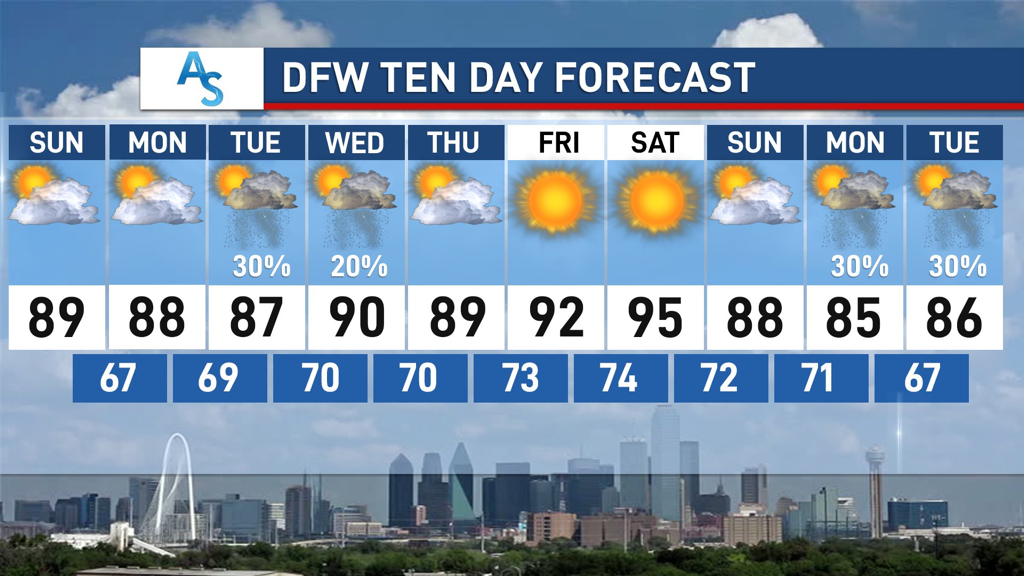 EARLY NEXT WEEK: A fairly uneventful start to the week will bring us plenty of sunshine for Sunday and Monday. While many places in Texas, especially the hill country, have considerable chances for rain and thunderstorms, we will stay dry in DFW. Temperatures could wander into the low 90s, but I expect them to follow our 10-Day Forecast pretty closely. The upper level ridge forming will make conditions extremely unfavorable for any sort of break in the pattern. However, there is a chance that an inverse trough (troughs usually go from North to South) brings moisture from the gulf by midweek, so there is a possibility for some low chances for rain on Tuesday and Wednesday that become increasingly higher the more southeast you go. However, since this ridge is quite strong (a classic omega blocking pattern taking shape), any rain will be minimal at best as it would have to traverse through adverse conditions to reach us. END OF WEEK: The inactive pattern will continue as we see average to slightly above temperatures for our transition into summer. In addition, we will be lucky to see very low, if any, chances for rain through Saturday. While this is lame for the meteorologists of the world, it’s very exciting for the general public. Since we have been dealing with a very complex and active pattern for most of May, this break in weather should allow for plenty of outdoor activities like running, biking, and other socially distant ways to enjoy the outdoors. Heat may become an issue by the end of the week, but we will more than likely stay within double digit temperatures for the foreseeable future.  UNCERTAIN FUTURE:
While the “boring” pattern persists through May and into early June, by next weekend all could possibly change. Many models are showing the possibility of Texas’s first tropical storm threat and, while it is entirely too far out to know if it will happen, it provides some uncertainty with what kind of weather DFW could be experiencing. An Upper Level Low is expected to form over Mexico and potentially spin off northward into the Gulf of Mexico. Early forecasting seems to indicate that shear will be relatively high over the Gulf, limiting the favorability for tropical development, but the ULL could turn into something tropical despite this. However, the block over the U.S. is likely going to still exist by next weekend, with the persistent ridge also making conditions unfavorable. It’s likely that DFW won’t be affected, but it could become a big rain producer for much of Coastal Texas and, if the path of the low moves due North, could provide some storms for us as well, if timing goes well enough for it. It’s extremely early and extremely volatile to forecast, as there are so many different variables that play into these results, so I will refrain from making any comments on what I think will happen. That being said, it’s important to stay weather aware and keep up to date with what’s happening. A good way to do this is to read Donovan’s daily weather blogs, in order to see what’s happening in the immediate future. Stay safe, stay hydrated, and stay weather aware! -Colin Welty RADAR CHECK: Strong to severe storms have developed in the Big Country this afternoon and are continuing to move to the southeast this evening. Some of these storms are severe with 60 mph winds and up to half-dollar sized hail, with flooding being a possibility with those that experience torrential downpours. The SPC maintains a low-end "marginal risk" of severe thunderstorms for much of the southern half of the North Texas region through the evening hours. The heavier storms could produce small hail and gusty winds. 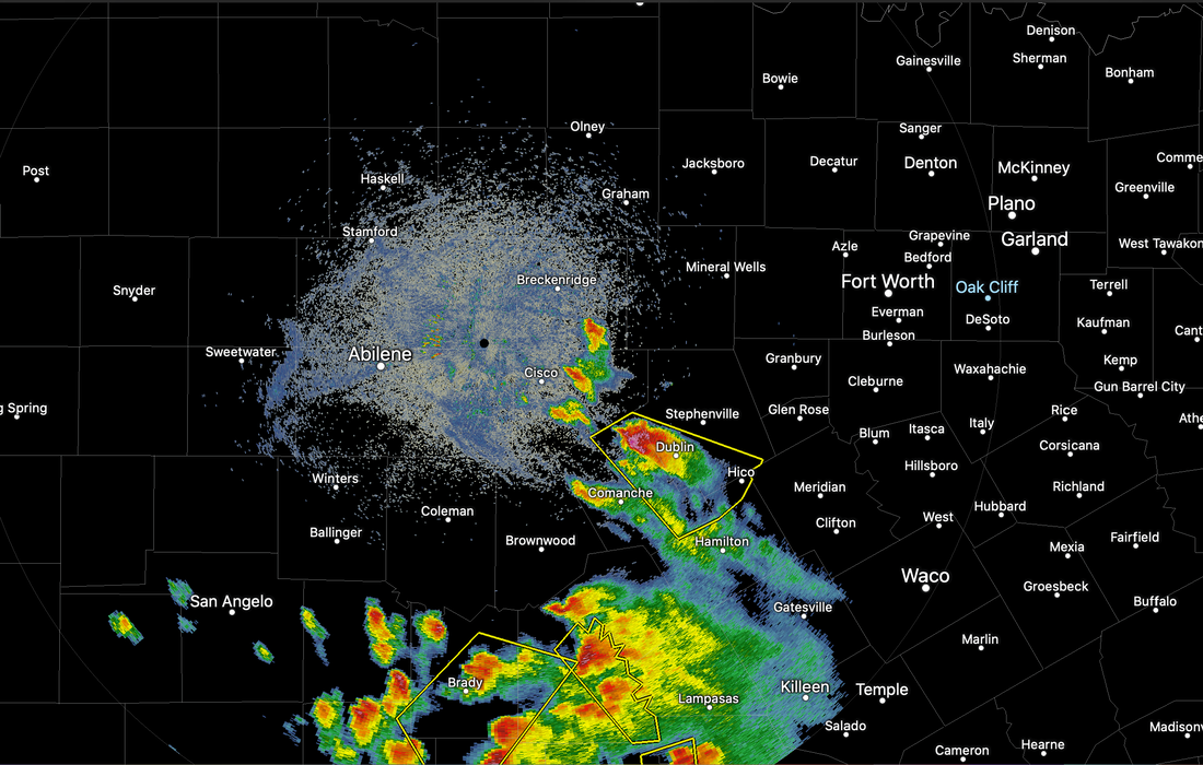 Temperatures remain mostly on average with readings mostly in the mid to upper 80s. The average high for Dallas/Fort-Worth on May 27 is 84. The upper low will continue to move slowly eastward, and we expect mostly dry conditions tomorrow, followed by completely dry weather by Friday. An isolated storm or two is possible on Thursday. We expect highs in the mid 80s tomorrow and Friday, with a good supply of sunshine. THE WEEKEND: Unusually dry air drops into the state over the weekend. Look for sunny days, fair nights, with a tad lower humidity levels. We will continue with highs around 85-87 Saturday and Sunday... many places will see lows in the low 60s Saturday morning. Very average to the end of May here in North Texas. NEXT WEEK: The weather looks very dry next week with a warming trend. Afternoon highs will reach the low to mid 90s by the end of the week. Showers and storms will be very limited in number, if any. 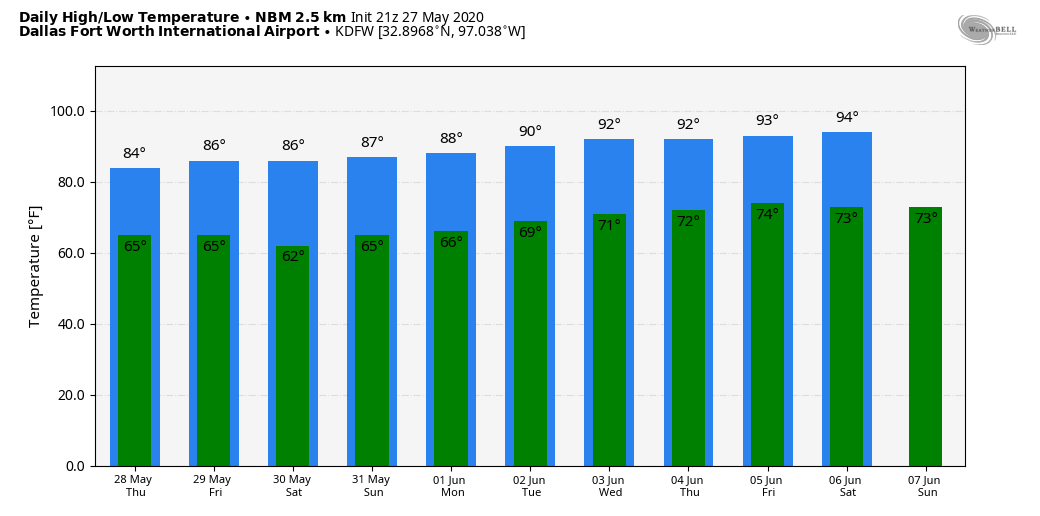 TROPICS: Tropical Storm Bertha formed quickly early this morning, just off the South Carolina coast. It is now inland, moving northward producing heavy rain as a tropical depression. The rest of the Atlantic Basin is quiet. The official start of the 2020 Atlantic Hurricane Season is June 1.
Look for the next weather discussion and blog update by noon tomorrow. Donovan Neal Owner - ApexStorm GRADUAL CLEARING: An upper low in East Texas will slowly drift away from us in coming days, gradually diminishing the chances of showers and storms for the next couple of days. This evening, we have a mix of sun and clouds in many locations, and temperatures are only in the low to mid 70s across much of the region. The average high for Dallas/Fort-Worth on May 26 is 86 degrees. Any isolated showers we see could linger on into the overnight hours. 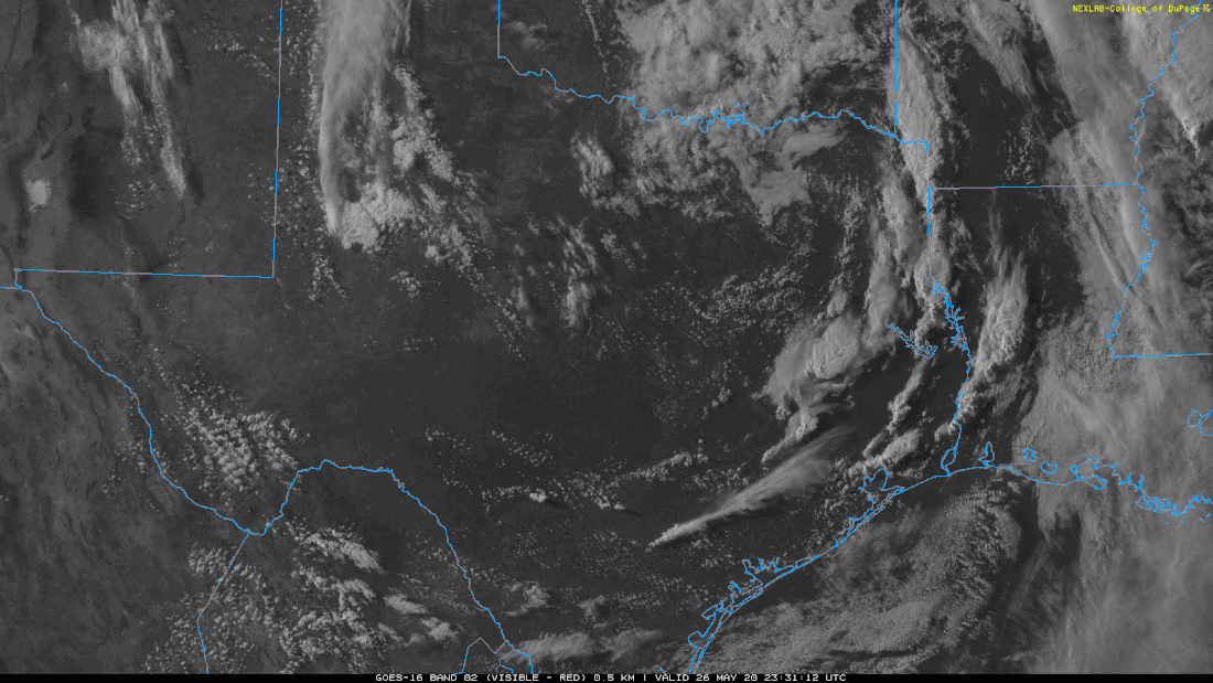 We will continue to forecast periods of scattered showers and thunderstorms during the afternoon and evening hours through Friday as the upper low continues to move out of here. The rain will not be continuous or widespread, and we will, of course, see periods of sunshine throughout. The overall pattern remains unsettled, and it is likely that the spots that do get wet will pick up an additional 0.15 inches of rain. If sufficient instability can develop, we have the potential for a few severe thunderstorms tomorrow afternoon and evening. The SPC has a low end "marginal risk" (level 1/5) of severe storms defined for the southern end of the North Texas region, with a higher severe risk further south toward Austin and San Antonio. 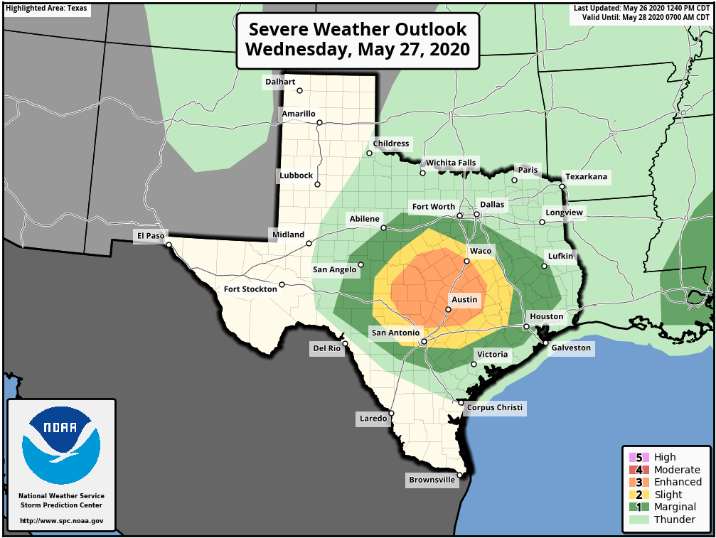 Where stronger storms develop, hail and strong wind gusts will be possible. THE WEEKEND: A very dry airmass for the end of May drops in here Friday, keeping us dry for a long time. The days will be mostly sunny with a tad lower humidity values, and after morning lows in the mid 60s, highs will be in the mid 80s, about average for late May. NEXT WEEK: Dry weather continues for most of the week with slowly increasing heat and humidity levels. We will likely reach the lower 90s by Wednesday. 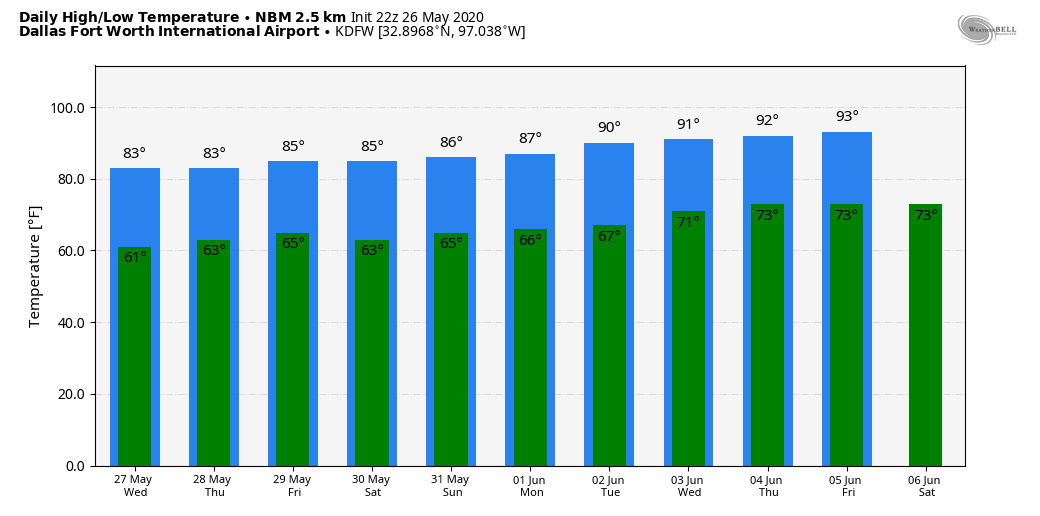 TROPICS: Showers and storms located over the northwestern Bahamas, extreme northeastern Florida, near Atlantic waters are in conjunction with an elongated surface trough interacting with an upper-level disturbance. Despite a weak surface low forming within the trough near Orlando, little, if any, further development of the system is expected as a result of land interaction, strong shear, and an abundance of dry air in the mid-levels.
Development or not, heavy rain could cause flooding over portions of the Carolinas tonight and Wednesday. Gusty winds could produce rough marine conditions and life-threatening surf and rip currents along the northeastern Florida, Georgia, and the Carolina coasts through tomorrow. Look for the next blog update here by 7:00 PM tomorrow. Donovan Neal Owner - ApexStorm RAINY MEMORIAL DAY: It has been very wet today with most of the Metroplex and North Texas region receiving rain at some point in the day. The general consensus has received an inch of rain over the past 24 hours, with many isolated spots of three inches or greater. The sky is mostly cloudy, and temperatures are in the 67-91 degree range this late afternoon. Rain will continue to move to the north with time. 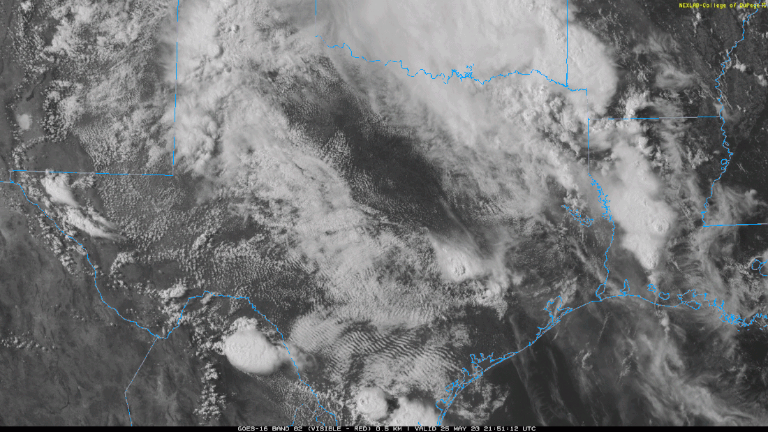 TUESDAY THROUGH THURSDAY: The upper-level trough in our state will begin to weaken and gradually move to the east, towards the Deep South. This will bring a noticeable decrease in the amount of showers and storms to the region during the mid-week period. Look for occasional showers and thunderstorms through Thursday. Highs will warm to the upper 70s to low 80s due to the lack of rain-cooled air. Rain distribution will not be even, but many communities will likely see an additional quarter of an inch of rain before the weekend. FRIDAY AND THE WEEKEND: The weather will trend drier by the weekend as an unusually dry airmass builds across the south-central US. Friday, Saturday, and Sunday are looking very pleasant with mostly sunny skies, lower humidity levels, and continued cool nights. Highs will be in the 80-85 degree range, and lows will mostly be in the upper 60s. NEXT WEEK: The first half of the week will continue to feature a dry airmass. Scattered storms might return to the forecast by the end of the week. 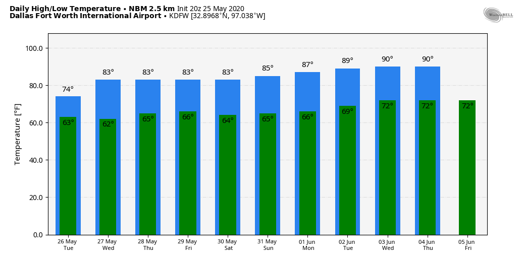 ON THIS DAY IN 2008: A rare, large, and destructive EF5 tornado created a 43-mile long path across Butler and Black Hawk counties in Iowa. This tornado killed eight people, injured dozens and caused several millions of dollars in damage. The tornado was nearly three-quarters of a mile wide as it moved through the southern end of Parkersburg. A third of the town was affected by devastating damage with nearly 200 homes destroyed. This storm produced the first EF5 tornado in Iowa since June 13, 1976 and only the third EF5 tornado to occur in the United States in the past ten years.
Look for the next North Texas Weather blog update by 5:30 PM tomorrow... Donovan Neal Owner-ApexStorm After a relatively dry and warm Saturday, clusters of scattered showers and storms returned to the metroplex today, bringing our tentative May rainfall up to 4.21 inches at DFW, despite local areas seeing even more rain. However, looking forward through the next week, the story will be more of the same as rain continues to play a factor every single day. Throughout the last week, and through the weekend, mesoscale convective systems (which I will refer to as MCS) plagued North Texas with spotty, scattered cells dropping plenty of rain for some and missing others entirely. The prevalence of multiple daily MCS will become prevalent throughout the week ahead, making it an extremely complicated setup for all forecasters as some places in Texas may see up to 5 inches of rain while others barely see a drop.  SEVERE SETUP OVERNIGHT: The first wave of scattered storms will develop this afternoon for much of Texas, with the possibility of hail for some. As the storms developed around DFW, they could be accompanied by up to golf ball sized hail and gusty winds caused by significant downdrafts. In addition, storms are likely to move into DFW overnight from the west, which could intercept the slow moving MCS that is around North Texas now. The squall line will be weakening as it enters the metroplex, but it is still plausible that some areas receive hail or straight-line winds. EARLY NEXT WEEK: Monday and Tuesday will continue to see multiple MCS move throughout the metroplex, with it being difficult to know who exactly will and won’t receive rain. The shortwave from the Rockies that moved in over the weekend, combined with a weakness found in the gulf, means that our rain profile will transition from severe storms to more of a tropical-like rain pattern, akin to places like Orlando. Clouds and rain will keep temperatures in the high 70s, but high dew points indicate that flash flooding will be extremely possible for areas that receive high amounts of rainfall, especially with the high amounts of continuous rain and high precip action rates that could happen early next week. Most of Texas will see heavy rain but scattered thunderstorms are still possible. That being said, the severe risk is considerably lower for the early part of next week than has been with previous events. All of this is the early shift to an eventual wet pattern that could be in place over Texas for weeks to come.  MID-WEEK VORTEX:
As the rest of the week progresses, a slow-moving ULL vortex will make its way over DFW by mid week, exacerbating the continuous rainfall conditions by sitting over parts of North Texas from late Tuesday through Friday. Similar to ULL events of the past (such as the one that brought a record 12 inches of snow to DFW in February of 2010!) indicate that the threat of floods will continue to increase throughout the week as high levels of sustained precipitation will impact weakened areas and potentially cause flash flooding. However, this combined ULL and MCS event is still a few days out, so being able to anticipate what areas will receive the most amount of rain is impossible at this time. While it’s likely that all parts of NTX could receive well over 2 inches of rain over the next 5 days, it’s not improbable that some areas receive rain every day while others only see rain one day. However, continue to prepare as if it will affect you—flooding is extremely dangerous and if you live in low-lying areas or around weak dams/smaller streams, pay extremely close attention to the weather as the week develops, as it will become apparent quickly whether or not the flood risk is greater or less than it appears to be right now. Throughout this whole event, temperatures are to remain in 70s mostly, as although highs are forecasted to be in the 80s, the prevalence of rain that is forecasted and the dew points indicate that temperatures will likely be suppressed by the rain. In summary, rain will be here to stay for this week and 2-5 inches of rain is extremely likely for most everyone. LOOKING FORWARD: The wet pattern continues! Confidence is increasing that we are nowhere near done with this wet pattern, and it could persist for weeks. There is an excerpt from the FWD AFD that I think best sums up how things are looking for the end of May and early June. “The rainfall will further strengthen the troughing aloft, which will in turn lead to more rain events.” As we get these prolonged, heavy rain events, it will, by default, delay a lot of ridging that brings us a lot of our summertime, dry heat. It’s looking more and more likely that we will continue to dodge triple digit weather in favor of wet conditions. Stay safe, stay dry, and stay weather aware! -Colin Welty |
Archives
April 2024
Categories |
 RSS Feed