
|
As you might recall, last week I called for some prolonged heavy rain events and a wet pattern to last us into June. And, as you are probably well aware, it has been very dry and warm the past 3 days in DFW. So, in summary, I was wrong. However, so too were the models, as the ULL came through way faster and hammered Central Texas with severe weather and allowed the ridging to form, giving us a plethora of hot and mostly cloudless days to work with for the end of May. So, what does this mean for North Texas? 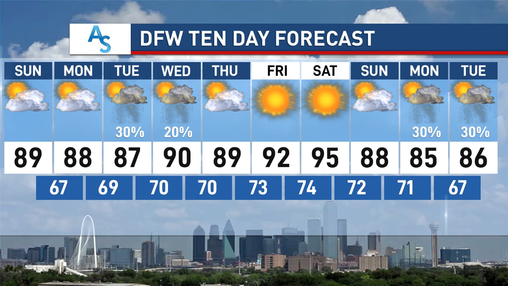 EARLY NEXT WEEK: A fairly uneventful start to the week will bring us plenty of sunshine for Sunday and Monday. While many places in Texas, especially the hill country, have considerable chances for rain and thunderstorms, we will stay dry in DFW. Temperatures could wander into the low 90s, but I expect them to follow our 10-Day Forecast pretty closely. The upper level ridge forming will make conditions extremely unfavorable for any sort of break in the pattern. However, there is a chance that an inverse trough (troughs usually go from North to South) brings moisture from the gulf by midweek, so there is a possibility for some low chances for rain on Tuesday and Wednesday that become increasingly higher the more southeast you go. However, since this ridge is quite strong (a classic omega blocking pattern taking shape), any rain will be minimal at best as it would have to traverse through adverse conditions to reach us. END OF WEEK: The inactive pattern will continue as we see average to slightly above temperatures for our transition into summer. In addition, we will be lucky to see very low, if any, chances for rain through Saturday. While this is lame for the meteorologists of the world, it’s very exciting for the general public. Since we have been dealing with a very complex and active pattern for most of May, this break in weather should allow for plenty of outdoor activities like running, biking, and other socially distant ways to enjoy the outdoors. Heat may become an issue by the end of the week, but we will more than likely stay within double digit temperatures for the foreseeable future.  UNCERTAIN FUTURE:
While the “boring” pattern persists through May and into early June, by next weekend all could possibly change. Many models are showing the possibility of Texas’s first tropical storm threat and, while it is entirely too far out to know if it will happen, it provides some uncertainty with what kind of weather DFW could be experiencing. An Upper Level Low is expected to form over Mexico and potentially spin off northward into the Gulf of Mexico. Early forecasting seems to indicate that shear will be relatively high over the Gulf, limiting the favorability for tropical development, but the ULL could turn into something tropical despite this. However, the block over the U.S. is likely going to still exist by next weekend, with the persistent ridge also making conditions unfavorable. It’s likely that DFW won’t be affected, but it could become a big rain producer for much of Coastal Texas and, if the path of the low moves due North, could provide some storms for us as well, if timing goes well enough for it. It’s extremely early and extremely volatile to forecast, as there are so many different variables that play into these results, so I will refrain from making any comments on what I think will happen. That being said, it’s important to stay weather aware and keep up to date with what’s happening. A good way to do this is to read Donovan’s daily weather blogs, in order to see what’s happening in the immediate future. Stay safe, stay hydrated, and stay weather aware! -Colin Welty |
Archives
March 2023
Categories |
 RSS Feed
